Tag: Harris Corporation

  • L3Harris Technologies merger completed

    L3Harris Technologies merger completed

    The Harris-supplied navigation payload before integration into the second GPS III SV. (Photo: Harris)
    The Harris-supplied navigation payload before integration into the second GPS III SV. (Photo: Harris)

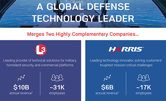
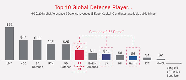
    L3Harris Technologies announced the successful completion of the all-stock merger between Harris Corporation and L3 Technologies on June 29. Headquartered in Melbourne, Florida, L3Harris becomes the sixth largest defense company in the U.S., and a top 10 defense company worldwide, with approximately $17 billion in revenue and 50,000 employees, including 20,000 engineers and scientists.

    Both companies have long been dominant presences in the U.S. GPS industry: Harris as a provider of the GPS satellite navigation payloads and geospatial intelligence software products, and L3 as a provider of military GPS user equipment and guided munitions. Both companies supply a wide range of other geospatially-related products as well.

    L3Harris has organized its operating businesses into four segments to best meet customers’ mission requirements and leverage the combined company’s broad technical capabilities:

    • Integrated Mission Systems — headquartered in Palm Bay, Florida, with approximately $4.9 billion in revenue. Includes intelligence, surveillance and reconnaissance; advanced electro optical and infrared solutions; and maritime power and navigation
    • Space and Airborne Systems — headquartered in Palm Bay, Florida, with approximately $4.0 billion in revenue. Includes space payloads, sensors and full-mission solutions; classified intelligence and cyber defense; avionics; and electronic warfare
    • Communication Systems — headquartered in Rochester, New York, with approximately $3.8 billion in revenue. Includes tactical communications; broadband communications; night vision; and public safety
    • Aviation Systems — headquartered in Arlington, Texas, with approximately $3.8 billion in revenue. Includes defense aviation products; security, detection and other commercial aviation products; air traffic management; and commercial and military pilot training

    Shares of Harris common stock, which traded on the NYSE under the ticker symbol “HRS,” began trading on July 2 under the ticker symbol “LHX.” L3 Technologies shares ceased trading upon market close on June 28 and have converted into 1.3 L3Harris shares for each L3 share.

    The merger comes at approximately the same time that two other leading GPS companies, Raytheon and United Technologies, itself a merger including the former Rockwell Collins, now Collins Aerospace, also merged.

  • Harris and Grand Sky partner on UAS BVLOS super corridor

    Harris and Grand Sky partner on UAS BVLOS super corridor

    Photo: IStock.com/valio 84sl, via FAA
    Photo: iStock.com/valio 84sl, via FAA

    Grand Sky Business and Aviation Park and Harris Corp. have joined forces to enable the country’s first and largest unmanned aerial system (UAS) airspace to support beyond visual line of sight (BVLOS) flight operations and UAS Traffic Management (UTM) research.

    Stretching up to 100 miles, this BVLOS “super corridor” is the most technologically sophisticated UAS airspace supported by multiple and redundant systems for cooperative and non-cooperative surveillance.

    These surveillance capabilities make possible a wide range of UAS BVLOS applications in precision farming, oil and gas, infrastructure inspection, public safety, package deliveries, and others.

    “Customers of Grand Sky will have access to a truly unique UAS operational capability, in addition to better facilities, comprehensive airspace surveillance, and wide operational areas,” Grand Sky Development Co. President Thomas Swoyer Jr., said. “We all benefit from efficient and safe BVLOS flight operations and a larger corridor with proven FAA collaboration and flight authorizations.”

    The surveillance system combines data feeds from a network of advanced sensors and towers. Two long-range primary radars located at Grand Forks Air Force Base and at Hillsboro, North Dakota, provide detection of non-cooperative aircraft.

    The Federal Aviation Administration (FAA) secondary radars and ADS-B network in the region, as well as local Harris ADS-B Xtend sensors, add additional layers of visibility for cooperative aircrafts in the airspace.

    Aviation-grade displays help pilots and electronic observers monitor the airspace environment over the BVLOS corridor and safely steer UAS from approaching manned aircraft.

    The combination of best practices in aviation safety management, proven technologies and experience with BVLOS regulatory approvals will make it easy for users of the airspace to advance UAS technology commercialization and routine, efficient flight operations.

    UAS operators can work with Grand Sky and Harris to develop, test, and refine a variety of complex BVLOS concepts of operations and secure waivers from the FAA for large-scale use.

    A full range of UAS operations can be supported for all types and sizes of unmanned aerial vehicles along the BVLOS corridor including a variety of airspace classes and execution of diverse defense, civil and commercial applications.

    “This is another first for Grand Sky and North Dakota in leading the UAS Industry,” Harris Vice President and General Manager of Commercial UAS Solutions George Kirov said. “The size and complexity of the airspace opened to UAS BVLOS operations is unmatched in the UAS industry. The sophistication of the Harris BVLOS system at Grand Sky is also unprecedented — linking Harris’ most advanced suite of surveillance and detect-and-avoid services with a variety of surveillance assets that, together, ensure the highest level of UAS aviation safety.”

    This partnership lays the foundation for larger and more capable surveillance corridors to enable UAS “highways” across the state of North Dakota and in support of expanding the variety of commercial UAS operations across the United States.

  • Going beyond the newest generation of GPS

    Going beyond the newest generation of GPS

    U.S. positioning, navigation and timing (PNT) capabilities are vitally important to millions of civilians, as well as U.S. and allied militaries.

    The third Navigation Technology Satellite will go beyond GPS III —­ whose capabilities, mark you, are not yet online — to investigate new experimental antennas, flexible and secure signals, increased automation and use of commercial ground assets.

    By Joe Rolli, Harris Corporation

    Space and Intelligence Segment. (Photo: Harris Corporation)
    Joe Rolli, Director of Business Development,
    Space and Intelligence Segment. (Photo: Harris Corporation)

    Over the past decade, military leadership and national strategists have shared their concerns about U.S. dependence on GPS for everything from financial transactions to commercial transportation scheduling to precision weapon system guidance.

    The new generation of Air Force GPS satellites, which began launching in late 2018, marks a significant step toward improving GPS services with three times greater accuracy and up to eight times improved anti-jamming capabilities over the previous GPS satellite block.

    Now the Air Force Research Laboratory and the Space and Missile Systems Center are focusing the Department of Defense’s first experimental Navigation Technology Satellite (NTS) in more than 40 years: on initiatives that will demonstrate new tactics, techniques, and procedures to improve PNT resiliency and counter threats to GPS.

    As a unique satellite that flies outside of the GPS constellation, NTS-3 will host experiments with impact across the PNT user spectrum — military, civil, academic and commercial. It will explore innovations in atomic clocks, antennas, reprogrammable digital waveform detectors, signals and other technologies.

    Harris, the satellite prime contractor for NTS-3, is approaching these mission innovations from the standpoints of responsiveness and resiliency as well as technology advancement. For example, the design will support the simultaneous broadcast of dual-frequency, regional high power, and Earth coverage signals. An agile waveform platform will demonstrate the ability to rapidly develop and deploy new signal waveforms with total flexibility throughout the satellite life cycle. These innovations will allow operation in multiple contested environments, a key to achieving resiliency that can combat electronic jamming, spoofing and more.

    Another strategy is the design of a modular NTS-3 payload that can be reprogrammed in space. Based on open, industry standards and interfaces, the payload will be scalable and can be hosted on diverse platforms and in varied orbits with minimal changes.

    When NTS-3 launches for its planned one-year experimental campaign — anticipated to begin in 2022 — it will be the latest in a series of experimental spacecraft that have blazed the trail for the extraordinary technological advances that led to the GPS system we enjoy today

  • Harris receives GPS III Follow-On payload contract

    Harris receives GPS III Follow-On payload contract

    Harris Corporation has received a $243 million contract from Lockheed Martin to provide fully digital navigation signals for the first two GPS III Follow-On (GPS IIIF) satellites — to deliver stronger signals, with greater operational flexibility.

    Harris’ GPS IIIF fully-digital Mission Data Unit (MDU), the heart of the satellite’s navigation payload which generates the GPS signals, will provide more powerful signals, assure flawless clock operations for GPS users, and add flexibility to adapt to advances in GPS technology, as well as future changes in mission needs.

    It will provide improved capabilities over Harris’ 70-percent-digital MDU used for GPS III Space Vehicles 01-10 (GPS III SV01-10).

    The new MDU also offers the Air Force a smooth transition to its GPS OCX ground control segment. Harris will seamlessly port its digital signal design, minimizing both integration risks and associated costs.

    In September 2018, the U.S. Air Force selected Lockheed Martin, with Harris as its navigation signal partner, to build up to 22 GPS IIIF satellites, with a total estimated contract value up to $7.2 billion.

    The Air Force expects the first GPS IIIF satellite, SV11, to be available for launch in 2026.

    Launched aboard GPS III SV01 in December 2018, Harris’ first GPS III navigation payload began broadcasting navigation signals on January 8. While testing of the first-of-its-kind satellite continues, the payload has performed beyond expectations.

    Harris has provided navigation technology for every U.S. GPS satellite ever launched, enabling the reliable GPS signal that millions of people — including U.S. soldiers — and billions of dollars in commerce depend on every day.

  • Air Force selects Harris Corp. as prime contractor for PNT satellite

    Air Force selects Harris Corp. as prime contractor for PNT satellite

    Satellite NTS-3 above Earth. (Illustration: Lt. Jacob Lutz, AFRL Space Vehicles Directorate)
    Satellite NTS-3 above Earth. (Illustration: Lt. Jacob Lutz, AFRL Space Vehicles Directorate)

    Harris Corporation has been selected as the prime contractor to build Navigation Technology Satellite-3, the next-generation experimental positioning, navigation and timing (PNT) spacecraft. The satellite, called NTS-3, is expected to launch in 2022, with one year of experimental operations.

    The Air Force Research Laboratory and the Space and Missile Systems Center selected Harris on Dec. 20, 2018, and announced it on Jan. 17.

    PNT Testbed

    As a unique testbed in geosynchronous orbit, NTS-3 will integrate several advanced technologies to demonstrate resiliency and new concepts of operation to include experimental antennas, flexible and secure signals, increased automation, and use of commercial ground assets.

    Technologies matured and knowledge gained from NTS-3 are expected to transition to future generations of GPS and augmentation layers for national PNT capabilities.

    Satellite NTS-3 closeup. (Illustration: Lt. Jacob Lutz, AFRL Space Vehicles Directorate)
    Satellite NTS-3 closeup. (Illustration: Lt. Jacob Lutz, AFRL Space Vehicles Directorate)

    “The National Defense Strategy tells us we must evolve our nation’s Position, Navigation, and Timing capabilities to be more resilient,” said AFRL Space Vehicles Director Col. Eric Felt. “NTS-3 is all about resiliency, and I am incredibly excited about the resiliency experiments our SMC, AFRL, and Harris team will be able to conduct with NTS-3’s innovative and flexible hardware, software, and waveforms.”

    Agile Waveform Platform

    In support of NTS-3, Harris plans to develop the Agile Waveform Platform, a digital signal generator that can be reprogrammed on-orbit, enabling operators to quickly develop and deploy new signals to meet rapidly-evolving needs on the battlefield.

    Additionally, Harris’ electronically steerable phase-array antenna will support simultaneous broadcast of multiple waveforms in both Earth-coverage and spot-beam configurations.

    NTS-3 will use Northrop Grumman Innovation System’s ESPAStar bus, building on AFRL’s EAGLE spacecraft that launched in April 2018.

    The NTS-3 Space Experiment

    Navigation Technology Satellite – 3 (NTS-3) was selected as the Space Vehicle Directorate’s next major integrated space experiment in 2015, and it represents AFRL’s first PNT flight experiment to prototype a more resilient PNT multi-layer architecture in accordance with the Space Enterprise Vision (SEV) and the Space Warfighting Construct (SWC).

    History of the program: NTS-1, 2 and 3. (Illustration: Lt. Jacob Lutz, AFRL Space Vehicles Directorate)
    Satellites NTS-1, 2 and 3. (Illustration: Lt. Jacob Lutz, AFRL Space Vehicles Directorate)

    NTS-3 builds on a heritage of Department of Defense (DoD) satellite navigation (SATNAV) success that began in the 1970s with the predecessors of the modern GPS constellation. NTS-1 was developed by the Naval Research Laboratory (NRL) and launched in 1974 with two rubidium-vapor frequency standards that advanced the timing and navigation precision demonstrated by the earlier TIMATION satellites.

    NTS-2 launched in 1977 as the first NAVSTAR GPS Phase I satellite, and demonstrated cesium frequency standards and a worldwide network for data acquisition. There has been no major DoD SATNAV developmental program for experimentation since then, until NTS-3.

    In 2017, AFRL restructured NTS-3 to emphasize mission objectives to demonstrate disaggregated, resilient PNT in a multi-layer space architecture, as outlined by the SEV and the SWC. NTS-3 will provide space qualification for core technologies such as on-orbit digital signal reprogrammability and solid-state amplifiers. In addition to new signals, onboard experiments include improvements to timing accuracy and integrity, including ensembling to improve long- and short-term stability. NTS-3 will demonstrate key tactics, techniques and procedures (TTPs) for multi-layer PNT through all three segments of the SATNAV system: space, control, and user.

    Ground Control

    Braxton Technologies was selected in June 2017 to handle NTS-3 SATNAV ground control, while demonstrating and maturing innovative and affordable ground-based command and control capabilities to ensure resilient PNT in contested and denied environments.

    Braxton experts also will demonstrate satellite ground-control technologies to inform future GPS ground-control systems. They will use the Multi-Mission Space Operations Center (MMSOC) open architecture standard, as well as the Air Force Satellite Control Network (AFSCN) for primary direct and secure communications with the future NTS-3 space payload.

    Satellite NTS-3 in space. (Illustration: Lt. Jacob Lutz, AFRL Space Vehicles Directorate)
    Satellite NTS-3 in space. (Illustration: Lt. Jacob Lutz, AFRL Space Vehicles Directorate)

    Ground control segment (GCS) objectives include commanding of multiple antennas to form high-gain regional beams in conjunction with traditional Earth coverage beams, and processing the subsequent impact on phase center bias and pattern variation.

    The GCS will also incorporate commercial antennas for TT&C and experiment with automation of common functions to reduce the level of manual control that GPS requires. GCS development will emphasize cyber security and compatibility with Enterprise Ground Services (EGS).

    Collaborators Wanted

    AFRL/RV is seeking collaboration from industry, government agencies, and universities in developing experimental concepts and participating in the flight experiment.

  • GPS World 2018 Leadership Awards overview

    GPS World 2018 Leadership Awards overview

    The 2018 GPS World Leadership Awards, presented in September, recognized significant recent achievement in Satellites, Signals, Services and Products. The Awards Dinner and Ceremony was sponsored by Harris Corporation, Rockwell Collins and Spirent Federal Systems.

    Check out a photo slideshow and videos from the event below, as well as speeches from each of the award winners.

    Satellites Leadership Award

    Giuliano Gatti | Space Segment Procurement Manager, European Space Agency

    Gatti received the award for his contribution to setting up the Galileo constellation from GIOVE-A and -B precursors through all Galileo operational satellites: Soyuz and Ariane 5 launches, a total of 26 Galileo satellites deployed in 7 years.

    Javier Benedicto, head of the Galileo Programme and Navigation-related Activities, European Space Agency, accepted the award and delivered these remarks on behalf of Gatti.

    Check out his speech here.

    Signals Leadership Award

    Logan Scott | Principal, LS Consulting

    Scott is the inventor of an asymmetric navigation security paradigm for civil GPS signals that avoids the need for secure key storage in civil receivers and allows for widespread adoption in applications without physical security capabilities.

    Check out his speech here.

    Services Leadership Award

    John Raquet | Director, Autonomy and Navigation Technology Center (ANT), U.S. Air Force Institute of Technology

    Raquet’s team has developed PNT sensors and systems utilizing GPS, GNSS, inertial, vision, lidar, magnetic field, pseudolites, radar, terrain mapping, signals of opportunity, star trackers, radio ranging, 3D audio, X-ray pulsars, clocks, and more.

    Check out his speech here.

    Products Leadership Award

    Andrew Simsky, Wim De Wilde, Jean-Marie Sleewaegen and Tom Willems | Navigation Algorithms Software Engineer, System Designer, System Architect, and Senior Researcher, Septentrio

    The Septentrio team received this award for developing the versatile PolaRx5 receivers, enabling many Earth-observing applications including worldwide ionosphere monitoring.

    Sleewaegen offers an acceptance speech on behalf of the team here.

    Photos

    Videos

    Click the symbol in the top left hand corner to choose the video you’d like to view.

    Words from our sponsors

    Satellites. “We have seen our military and professional users looking to greater flexibility in their use of GNSS, as new capabilities and constellations come on line. But with that flexibility, a retention of assurance and where possible, mitigation of threats. For this reason Rockwell Collins and QinetiQ signed an agreement to produce a new family of high-assurance, multi-constellation GNSS receivers for professional and military use.

    “This new family of receivers, complementary to the current encrypted family of Rockwell Collins receivers in service across the globe, allows the customer to select level of capability and protection based upon their operational, political or even financial needs. The new MICRO family of GNSS receivers will offer a multi-constellation open service (MCOS) GNSS capability, which will initially provide two receivers; the Q40-MicroPNT will address dismounted low-dynamics requirements, and the Q40-MicroSTRIKE will be a gun-hard, high-dynamics receiver.”
    —Phil Froom, Rockwell Collins

    Signals. “For over thirty years, we’ve overcome challenges and delivered GPS payloads that provide a technology the world uses every day. We’ve gotten to the point where we can honestly say, almost nothing works without GPS. The challenge that I see [for the future] is to overcome the politics: Where do governments of GNSS draw the line between doing what’s right for a PNT solution for the common good of humanity globally versus addressing your national security and protecting your own country? Truth is, because of politics, year after year our government has been forced to start the fiscal year with a continuing resolution because our politicians can’t approve a budget.”
    —Joe Rolli, Harris Corporation

    Services. “We’ve been manufacturing GPS simulators for the past 30 years. This year we launch a new product, SimMNSA. We’re currently in the final test phase of this new M-code option and we’ll be delivering to several authorized customers by the end of the year. We also offer products that simulate all other GNSS signals, plus a variety of other sensors.”
    —Ellen Hall, Spirent Federal

  • Logan Scott accepts the 2018 Signals Leadership Award

    Logan Scott of LS Consulting received the 2018 Signals Award. Joe Rolli from Harris Corporation was on hand during the GPS World Leadership Dinner and Awards ceremony to present the award.

  • Defense companies Harris and L3 Technologies to merge

    Defense companies Harris and L3 Technologies to merge

    Harris Corporation and L3 Technologies Inc. have agreed to combine in an all-stock merger of equals to create a global defense technology leader focused on developing differentiated and mission-critical solutions for customers around the world.

    The combined company, L3 Harris Technologies, will be the sixth largest defense company in the U.S. and a top 10 defense company globally, with approximately 48,000 employees and customers in more than 100 countries.

    For 2018, the combined company is expected to generate net revenue of approximately $16 billion.

    Image: from Fact Sheet by Harris and L3 Techologies
    Image: from Fact Sheet by Harris and L3 Technologies

    According to the press release, increased scale will enable the combined company to be more cost competitive, expand capabilities to provide end-to-end solutions across multiple domains of air, sea, land, space and cyber, enhance leadership in RF and spectrum technologies and establish a leading platform-agnostic supplier and integrator.

    L3 Harris Technologies will be headquartered in Melbourne, Florida, and led by a team that reflects the strengths and capabilities of both companies and will share equally in the integration process, the companies said.

    With a combined workforce of 22,500 engineers and scientists, the combined company plans to accelerate investment in select technologies to expand leadership in key strategic domains including national security.

    Image: from Fact Sheet by Harris and L3 Techologies
    Image: from Fact Sheet by Harris and L3 Technologies

    Company Backgrounds

    Harris Corporation is a solves customers’ mission-critical challenges by providing solutions that connect, inform and protect. Harris supports government and commercial customers in more than 100 countries and has approximately $6 billion in annual revenue. The company is organized into three business segments: Communication Systems, Electronic Systems and Space and Intelligence Systems.

    L3 Technologies is a provider of global ISR, communications and electronic systems for military, homeland security and commercial aviation customers. With headquarters in New York City and approximately 31,000 employees worldwide, L3 Technologies develops advanced defense technologies and commercial solutions in pilot training, aviation security, night vision and EO/IR, weapons, maritime systems and space. The company reported 2017 sales of $9.6 billion.

    CEO Statements and Leadership

    “This transaction extends our position as a premier global defense technology company that unlocks additional growth opportunities and generates value for our customers, employees and shareholders,” said Harris chairman, president and CEO William M. Brown. “Combining our complementary franchises and extensive technology portfolios will enable us to accelerate innovation to better serve our customers, deliver significant operating synergies and produce strong free cash flow, which we will deploy to drive shareholder value. Integration planning is already underway, and from our extensive experience with integration, we are confident in our ability to realize $500 million of annual gross cost synergies and $3 billion of free cash flow by year 3.”

    L3 Chairman, President and Chief Executive Officer, Christopher E. Kubasik said, “This merger creates greater benefits and growth opportunities than either company could have achieved alone. The companies were on similar growth trajectories and this combination accelerates the journey to becoming a more agile, integrated and innovative non-traditional 6th Prime focused on investing in important, next-generation technologies. L3 Harris Technologies will possess a wealth of technologies and a talented and engaged workforce. By unleashing this potential, we will strengthen our core franchises, expand into new and adjacent markets and enhance our global presence.”

    The combined company’s board of directors will have 12 members, consisting of six directors from each company. William M. Brown will serve as chairman and chief executive officer, and Christopher E. Kubasik will serve as vice chairman, president and chief operating officer for the first two years following the closing of the transaction. For the third year, Brown will transition to executive chairman and Kubasik to chief executive officer, after which Kubasik will become chairman and chief executive officer.

    Additional senior leadership positions for L3 Harris Technologies will be determined at a later date.

    Shareholder Information

    Under the terms of the merger agreement, which was unanimously approved by the boards of directors of both companies, L3 shareholders will receive a fixed exchange ratio of 1.30 shares of Harris common stock for each share of L3 common stock, consistent with the 60-trading day average exchange ratio of the two companies.

    Upon completion of the merger, Harris shareholders will own approximately 54 percent and L3 shareholders will own approximately 46 percent of the combined company on a fully diluted basis.

    The merger is expected to close in mid-calendar year 2019, subject to satisfaction of customary closing conditions, including receipt of regulatory approvals and approval by the shareholders of each company.


  • Harris showcases GPS navigation satellite capabilities at ION GNSS+ 2018

    Harris Corporation’s Jason Hendrix discusses the company’s capabilities for GPS navigation satellites at ION GNSS+ 2018, which took place Sept. 24-28 in Miami.
     
     
    (Background image: iStock.com/imaginima)

  • Harris wins three 10-year NGA geospatial data contracts

    Harris wins three 10-year NGA geospatial data contracts

    Earth's western hemisphere, 2002. (Photo: NASA)
    Earth’s western hemisphere, 2002. (Photo: NASA)

    Harris Corporation has been awarded three multi-award indefinite delivery/indefinite quantity (IDIQ) contracts with ceilings totaling $1.5 billion to provide the National Geospatial-Intelligence Agency (NGA) with geospatial data services for up to 10 years.

    Harris will create, manage and disseminate high-quality geospatial-intelligence (GEOINT) information for use by the U.S. intelligence community and military worldwide under contracts that cover all three areas of NGA’s JANUS program — geography, imagery and elevation.

    The JANUS program will contribute to and maintain comprehensive, geospatially accurate databases of the world that can be accessed quickly as intelligence, operational and crisis needs arise.

    Harris will use its predictive analytics technology to continuously evaluate the health of NGA databases and to guide the acquisition, creation and integration of all forms of geospatial data. Harris’ cloud-based tools will validate and correct the data — pinpointing locations that require updates.

    “Winning JANUS continues our long-standing legacy of providing high-quality, responsive GEOINT and analytics to the intelligence and military communities,” said Bill Gattle, president, Harris Space and Intelligence Systems. “Our analytics technology provides NGA with fit-for-purpose data, reduced production costs and cloud-based access to geospatial products and content.”

    Harris is investing in new technologies that improve the speed and accuracy of providing GEOINT products. The company has partnered with the NGA for almost 20 years to provide automated geospatial data processing, data management, and geospatial systems design and development. Harris provides high resolution geospatial data content and products under NGA’s Foundation GEOINT Content Management program, and previously supported the Global Geospatial-Intelligence program.

    Hexagon US Federal Also Contracted

    The NGA also has selected Hexagon US Federal as a prime contractor on two multiple award, indefinite delivery/indefinite quantity contracts for amounts totaling $1.17 billion for the JANUS Geography and JANUS Elevation contracts.

    JANUS Geography. Hexagon’s tasks for the JANUS Geography program will support the creation, conflation, integration and enrichment of Foundation GEOINT data used to produce a comprehensive and seamless dataset for NGA partners and customers.

    The creation of this dataset will ensure more accurate and readily available geospatial data for military and intelligence operations as well as disaster relief missions saving time and lives.

    JANUS Elevation. As a prime contractor on the JANUS Elevation contract, Hexagon will support NGA’s Office of Geomatics with maintenance to an existing worldwide library of digital elevation models. The effort includes products generated, modified or assessed by the office that are a digital representation of the terrain surface of the Earth.

  • Harris showcases PrecisionPass solution at Xponential 2018

    Harris showcases PrecisionPass solution at Xponential 2018

    Rebecca Lasica, director of enterprise platforms and partners at Harris Geospatial Solutions, offers a rundown on the company’s PrecisionPass solution at Xponential 2018. According to the company, PrecisionPass enables UAV pilots to quickly determine in the field if a data collection meets the required criteria or if it needs to be collected again.

  • Harris Corporation delivers fifth GPS III satellite navigation payload

    Harris Corporation delivers fifth GPS III satellite navigation payload

    Harris Corporation has provided Lockheed Martin with its fifth of 10 advanced navigation payloads contracted for the U.S. Air Force GPS III satellite program.

    The GPS III navigation payload features a Mission Data Unit (MDU) with a 70-percent digital design that links atomic clocks, radiation-hardened computers and powerful transmitters — enabling signals three times more accurate than those on current GPS satellites, the company said.

    The payload also boosts satellite signal power, increases jamming resistance by eight times and helps extend the satellite’s lifespan.

    Lockheed Martin successfully integrated the navigation payload into the fifth GPS III space vehicle (GPS III SV05). Harris is committed to delivering three more payloads by the first quarter of calendar year 2019 for GPS III SVs 06-08.

    Four navigation payloads have already been fully integrated on GPS III SV01-SV04. In September 2017, the Air Force declared the first GPS III satellite Available for Launch (AFL) with launch expected later in 2018.

    In December 2017, GPS III SV02 completed rigorous thermal vacuum testing and is expected to be declared AFL this summer. GPS III SV03 and SV04 are expected to undergo environmental testing this year.

    In November 2017, Harris announced that it completed development of an even more-powerful, fully digital MDU for the Air Force’s GPS III Follow On (GPS IIIF) program. The new GPS IIIF payload design will further enhance the satellite’s capabilities and performance for the Air Force.

    Harris’ expertise in creating and sending GPS signals extends back to the mid-1970s — providing navigation technology for every U.S. GPS satellite ever launched. While the Air Force originally developed GPS for warfighters, millions of people around the world and billions of dollars of commerce now depend on the accurate, reliable signal created and sent by Harris navigation technology.