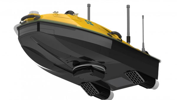
SatLab has introduced the HydroBoat 1200MB, a compact uncrewed surface vehicle (USV) system engineered for 3D hydrographic surveying in inland and nearshore waters. The system integrates SatLab’s autonomous vessel platform with the HydroBeam M2 multibeam echosounder, providing a portable solution intended to streamline data collection in shallow or confined environments.
The HydroBoat 1200MB is developed as a fully integrated unit, combining navigation, sonar data acquisition, real-time visualization and data management. According to the company, it is designed to assist small teams in conducting geospatial reconnaissance and hydrographic assessments with minimal setup and reduced operational complexity.
SatLab reports that the system supports a seamless workflow, from survey planning through to the delivery of final results. The vessel features an integrated inertial navigation system that delivers roll, pitch and yaw measurements without requiring field calibration. Its real-time data visualization capabilities allow users to view high-resolution 3D point clouds, bathymetric profiles and sidescan imagery across multiple devices, which allows for immediate quality control and decision-making in the field.
The HydroBoat 1200MB incorporates SatLab’s proprietary sound speed profile inversion technology, which enables real-time sound velocity correction without the need for separate sound velocity profilers. The system is designed for operational efficiency, with deployment possible in under five minutes and control managed through an Android-based interface.
Equipped with a multibeam configuration offering 512 beams and a swath coverage of 30 to 150 degrees, the HydroBoat 1200MB is intended to allow users to survey larger areas compared to singlebeam alternatives. According to SatLab, this configuration can result in up to a 7.5-fold increase in survey efficiency and potential cost reductions of up to 50%, due to the elimination of auxiliary equipment and simplified field operations.
The HydroBoat 1200MB can be used in a variety of applications, including river and reservoir surveys, bank mapping, structural inspections, sediment transport monitoring and infrastructure assessment. It is designed to meet data quality standards set by the International Hydrographic Organization, the Canadian Hydrographic Service and the U.S. Army Corps of Engineers.
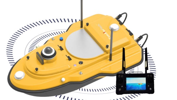
ComNav Technology has released the SV600 unmanned surface vessel (USV) for hydrographic surveying. This remote-controlled vessel incorporates adaptive water-flow straight-line and hovering technology, enhancing efficiency and ease of operation.
A key feature of the SV600 is its dual-moon pool design, which allows for simultaneous deployment of various surveying equipment. This includes Acoustic Doppler current profilers, single-beam echo sounders, side-scan sonar, pipeline detectors and miniaturized multi-beam echo sounders.
The vessel’s design prioritizes versatility and quick transitions between tasks. Its rapid installation feature facilitates seamless switching between different measurement modes, streamlining the surveying process, according to ComNav.
For centuries before sonar, lidar and unmanned surface vehicles (USVs), sailors would measure depths by throwing a line overboard with a lead weight at the end — called a leadline — and record its length to the seafloor. Mapping large areas of the seafloor, therefore, required thousands of these measurements.
However, even after extensive measurement efforts, the acquired data was often inaccurate or incomplete, which forced navigators and surveyors to estimate the seafloor’s bathymetry until remote sensing was introduced in the 1970s.
Since then, the growing need for increasingly accurate and rapidly available data has led to a worldwide effort to develop sensors and alternative techniques for measuring depths.
In the ongoing Florida Seafloor Mapping Initiative (FSMI), the Florida Department of Environmental Protection tasked Woolpert Geospatial Program with acquiring bathymetric survey data using lidar technologies to produce a comprehensive, publicly available, high-resolution seafloor surface model of Florida’s coastal waters by 2026.
Similar initiatives across the globe have kick-started innovations in underwater data collection and interpretation. In this feature, SBG Systems, CHC Navigation (CHCNAV) and Advanced Navigation describe how they used modern hydrographic surveying to aid defense departments, produce 3D topographic maps, and analyze the depth of The Great Blue Hole in Belize.
Exploring challenging waters
SBG Systems
Advancements in hydrographic surveys can lead to the exploration of depths previously unknown. The Great Blue Hole, located off the coast of Belize, is the largest marine sinkhole in the world, with a diameter of 300 m and a depth of 125 m. This major scuba hotspot is part of the Belize Barrier Reef Reserve System and a UNESCO World Heritage Site.
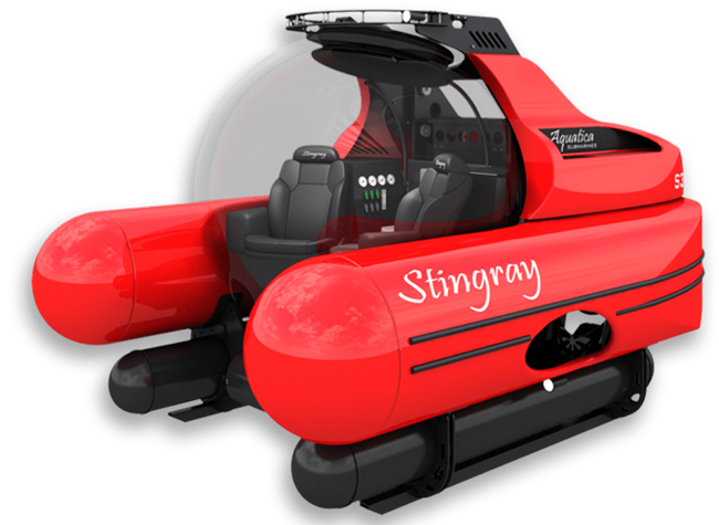
Aquatica Submarines conducted an expedition survey of the Blue Hole. For two weeks, a team of scientists, explorers, and filmmakers collected survey data and captured photos and videos of this geological wonder. It is the first time in history that an expedition of this scale was attempted at the Blue Hole.
The challenge: Finding submersibles to equip with sonar
The expedition team chose two submarines to carry out the survey: its Stingray 500 and the Roatan Institute of Deepsea Exploration’s IDABEL. Both vessels can carry up to three persons for a maximum of 12 hours.
Norwegian technology group Kongsberg’s dual-axis sonar technology was used to create a 3D representation of the sinkhole. The surface and submarine-mounted sonar equipment were also equipped with SBG Systems’ Ellipse miniature inertial navigation system (INS).
The Ellipse was used to mark the Blue Hole perimeter and scientists then processed the recorded data using MS1000 processing software.
Additional steps and results: Analyzing 3D sonar maps
A key outcome of the expedition is the creation of a complete 3D sonar map of the Blue Hole using point-cloud data collected by Kongsberg’s dual-axis sonar to create a 3D map of the site. The sonar was pole-mounted on the survey vessel with the GPS receiver and motion reference unit directly over the scanner’s head.
Sonar expert Mark Atherton from Kongsberg’s Canadian subsidiary, Kongsberg Mesotech, was a key member of the science-based sonar and data collection team. Atherton operated the sonars aboard the Research Vessel Brooks McCall, contributing to an invaluable high-resolution map of the entire sinkhole.
“By understanding the geological history and geometric structure at the Blue Hole, we can contribute new data to the global scientific community studying sinkholes and cenotes,” Atherton said.
The team was able to conduct more than 20 dives into the large sinkhole, taking videos and 3D images during each trip. They also completed a two-hour live broadcast featured on The Discovery Channel.
“What [the Great Blue Hole] tells us is that sea level rise is not [always] a gradual process,” said Erika Bergman, Aquatica’s chief pilot and oceanographer. “We carefully measured the terraces and layers built up in the hole and we can see that sea level rise can happen dramatically.”
Producing 3D hydrodynamic models
CHC Navigation
Flood control structures — such as dikes, dams, spurs, drainage channels, and floodways — are designed to protect coastal and riverine areas of cities and farms and, above all, the people who live there.
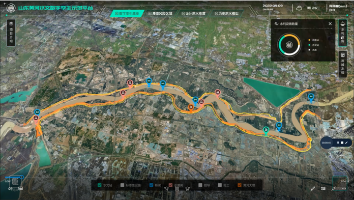
To prevent flooding in low-lying regions and support national ecological protection and development strategies in the Yellow River Basin in China, the Ministry of Water Resources launched the “Digital Twin Yellow River Construction Plan (2022-2025)” project. The Chinese Bureau of Hydrology and Water Resources was tasked with building a digital twin flood model based on part of the country’s Yellow River, targeting the 28-km section of the river basin.
The challenge: Building and designing a digital twin flood model
The first step was to acquire 3D data underwater, on land, and from the air. CHC Navigation (CHCNAV) provided its Apache 6 and Apache 4 USVs to collect underwater data using multi-beam and single-beam echo sounders. The AlphaUni lidar system mounted on the BB4 UAV was used to gather the land data. Finally, the team obtained aerial data using an oblique photographic system from CHCNAV mounted on a UAV.
As a result, researchers obtained large-scale remote sensing images, laser point clouds, terrain data, oblique photography, CAD drawings, and BIM models.
The simulation and analysis of the historical flood events on the third party software; based on the data collected by CHCNAV’s USV and UAV. (Image: CHCNAV)
CoPre software, a 3D laser scanning pre-processing software that can process captured raw data, including POS trajectories, lidar data, and RGB images, was used for the Tilt and DOM modeling.
CoProcess software, designed for reality capture post-processing tasks and DEM/DTM generation, generated high-precision DEM models, a 3D representation of a ground surface created from elevation data, with a point cloud density of more than 50 points/m2 for the areas above and below the water.
Additional steps
The remotely operated vehicles and generated models obtained site data such as climate records, flood maps, flow records, hydrologic summaries, groundwater level records, water quality, and resource data to use as the basis of the analysis.
The team also used historical flood information during the scoping phase to develop a conceptual model of the flood mechanisms. Based on the actual flood records, a third-party flood simulation platform was used to produce the entire flood process for the different years.
The real-time flood extrapolation was processed on the third-party software, which simulated steady and unsteady flow patterns using hydrodynamic modeling algorithms.
“Advancements in bathymetric surveying, incorporating cutting-edge technologies such as UAVs with lidar, USVs with echo sounders, and high-precision positioning systems, have transformed the creation of digital twin models for water bodies, particularly the Yellow River in China,” said Taxiya Wang, Business Development Manager of Marine Survey at CHC Navigation. “This bathymetric surveying effort has laid the foundation for hydraulic models, flood maps, and customized applications, emphasizing the importance of up-to-date, high-quality data in watershed engineering and construction projects.”
The result
Based on the developed digital flood model, the next step for the digital watershed twin project is to collaborate with technical staff, experts, and users to create customized applications for watershed engineering and construction. The project is ongoing and will end in 2025.
Surveying wet gaps
Advanced Navigation
Defense departments are continuously looking to improve the safety of military personnel and equipment in conflict regions. With this aim, the UK Defense Science and Technology Laboratory (DSTL) launched its “Map the Gap” competition. It invited engineering firms to design and build an unmanned surface vessel (USV) capable of quickly, reliably, and safely surveying wet gaps — including rivers, streams, canals, and waterways — without putting engineers and other personnel at risk. Commanders can then view the survey data to determine the safest crossing points for troops and equipment.
DSTL relied on Advanced Navigation’s Spatial FOG Dual fiber optic gyroscope to conduct the hydrographic surveying project.
The challenge: Building a USV to assist defense forces
Challenges in the project included measuring water depths and flow rates, crossing lengths, river-bed topography, and riverbank heights, as well as shape profiling and assessing ground load handling capabilities. The vehicles also had to be either remotely operated or fully autonomous and deliver the collected data in a way that could be easily interpreted for quick decision-making.
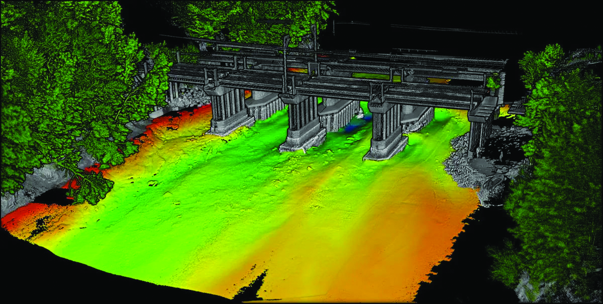
The survey required multiple sensor technologies for simultaneous above- and below-water 3D surveys. For above-water use, dual lidar sensors produce high-resolution point clouds of the surrounding environment. For below-water mapping, a sensor suite consisting of a multibeam sonar, an Acoustic Doppler Current Profiler/Doppler Velocity Log (ADCP/DVL), and a cone penetrometer were used to measure current and water flow as well as to test substrate density.
Ultrabeam Hydrographic won the DSTL competition. Its team integrated multiple sensors into a single housing and selected the four-wheeled Axolotl vehicle for the second phase of the project.
Additional steps
An example of the highly detailed single-3D survey output from the Axolotl, showing features both above and below the water. (Image: Advanced Navigation)
The team was in search of a GNSS/INS device capable of dead-reckoning and maintaining accurate heading for extended periods of time, which led them to Advanced Navigation’s Spatial FOG Dual GNSS/INS.
Ultrabeam Hydrographic had previously been using a MEMS-based solution that could maintain a suitably accurate heading without GNSS for up to approximately 60 seconds. However, tests with the Spatial FOG Dual showed that it could maintain an accurate heading for more than 15 minutes.
“The MEMS can hold onto heading for maybe 30 seconds to a minute, accurately. After that, it’s not reliable,” Gabriel Walton, Ultrabeam Hydrographic’s technical director said. “We have used the Spatial FOG Dual in certain circumstances where we went 10 to 15 minutes without GNSS. I do believe it will go on for longer.”
The team integrated the Advanced Navigation solution into their survey management and mission control software. This allowed the Spatial FOG Dual to be used for survey purposes and to provide motion data to the robot’s artificial intelligence (AI) for autonomous mission control and object detection and avoidance.
The result
“Map the Gap” Phase 2 demonstrated that the Axolotl’s mechanical design, sensor suite integration, extensive use of AI for autonomous mission control, decision-making and precise navigation can serve as a significant advancement for bathymetric surveying.
Since “Map the Gap,” Ultrabeam Hydrographic has deployed the Axolotl on commercial waterway survey missions, such as surveying bridge sites and attaining a clear understanding of riverbed and water conditions.
To improve the efficiency of their hydrographic surveying services and expand them, Coastal Geomatics evaluated multiple USV, choosing the CHC Apache 4. (Image: Coastal Geomatics)
Time (and costs) saved using unmanned surface vessels (USV) over conventional methods for hydrography can be dramatic — especially in autonomous mode. Numerous firms, large and small, have discovered how modest investments in such craft can completely revolutionize their hydrographic operations. One such firm is the family owned and operated Coastal Geomatics in North Carolina.
“With conventional methods, it used to take us four weeks with a three- or four-person crew to do the bathymetry for 26 canals that we do every two years for the City of Holden Beach,” Chris Stanley, owner and manager of Coastal Geomatics, said. “Now, with our Apache we do this over four days of high tide; about four to five hours per day.”
Stanley had been surveying in the local area for more than 30 years and had partnered in several local firms. In 2020, he decided to start his own firm, together with his two adult sons Alan and Ian: Coastal Geomatics was born.
“We do a lot of boundary work, and topographic surveys as there is a lot of construction going on in the area,” Alan said. “We also do flood insurance work, FEMA elevation certificates, and hydrographic work — we are on the coast.” Holden Beach is on one of North Carolina’s barrier islands, separated from the mainland by the Intercoastal Waterway. Coastal Geomatics has standing contracts to do hydro work for FEMA beach erosion annually, and the biennial canal surveys for the city.
The move to a USV for hydrographic surveys made a lot of sense, however a past bad experience with the technology prompted Stanley to be extra diligent in choosing a boat. At one firm for which the elder Stanley had worked in the past, they had acquired a USV that he said was essentially “a jet ski, with a mix of components cobbled together.” He added that they had never really gotten it to work right, and it now sits idle in a storage unit.
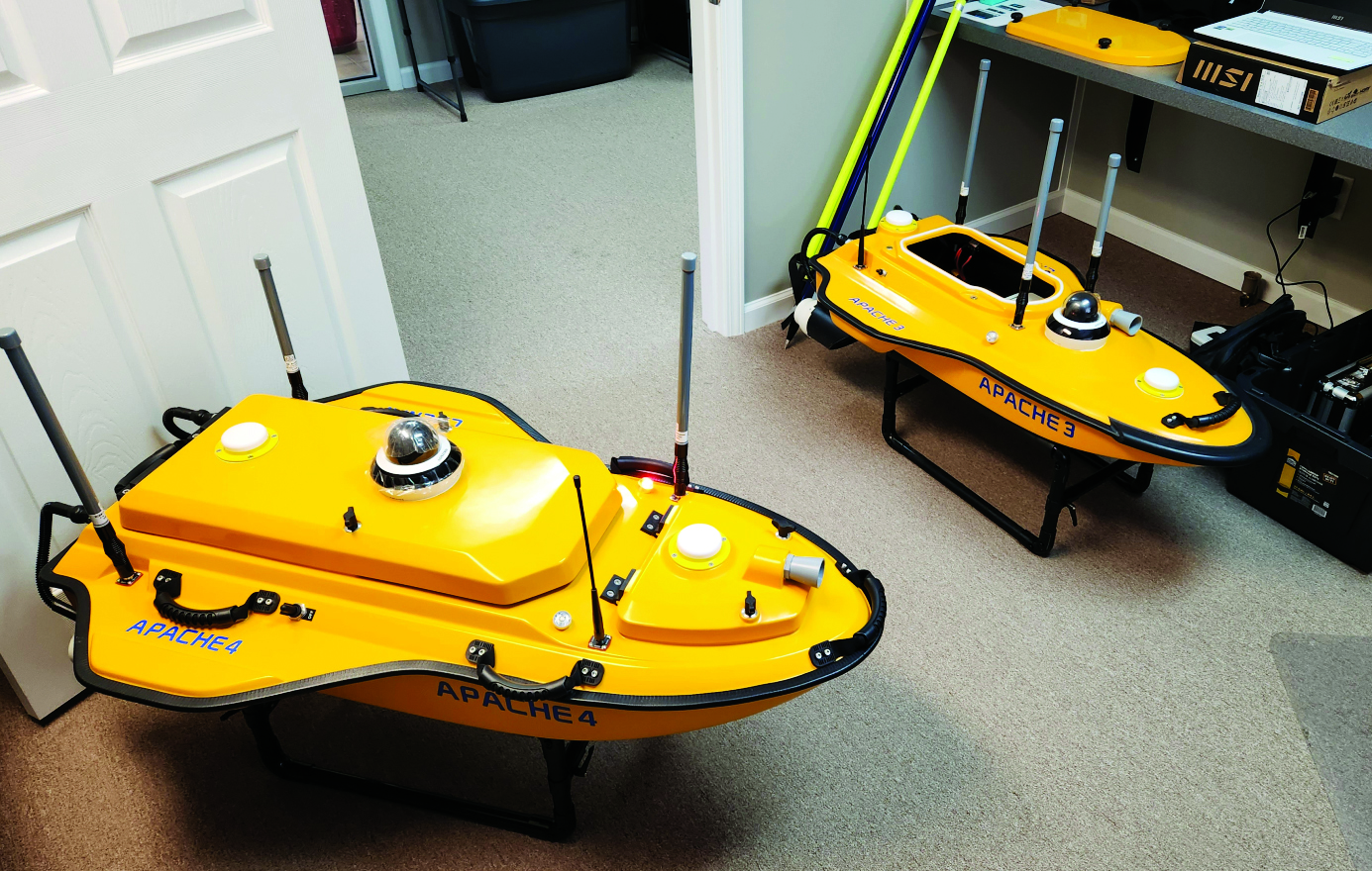
The Stanleys did some research on the current state of small USV, noting that some still seem like “contraptions” and decided instead to test out three models from CHC Navigation: the Apache 3, 4, and 6. They had considered the tri-hulled Apache 6 for some offshore work they sometimes do, however, they chose the Apache 4 for now. It has a dual GNSS antennas for position and heading that is tightly coupled with an IMU for uninterrupted positions, a single beam echo sounder, and a 360° camera. It has a sensor well that can accommodate most of the popular models of acoustic doppler current profilers (ADCP), though Coastal Geomatics is not presently using an ADCP. It can be run fully autonomously for missions defined in the AutoPlanner software, or remotely piloted — Coastal Geomatics needed both options. They noted how the boat is compact, easy to operate, and all components are well integrated with watertight seals.
For open water areas of their contracted surveys, they put the USV in full autonomous mode, where they say it is quite efficient. However, there are specific tasks where a remote pilot needs to take over.
The canals surveyed for the city to inform dredging operations are about 100 feet wide and each house has a floating dock. There is a 20- to 30-foot strip between the docks. The old method, Ian explained, was to put one of the crew in a small flat bottomed Jon boat, with a crew member on each side of the canal, often with a fourth using a total station. Points across the canal from bulkhead to bulkhead were taken with a long prism pole, handing the pole off to the crew member on the other side after each crossing. The dynamics of which residents’ boats might be at the docks on any given day made full autonomy for that phase of the surveys impractical.
Coastal Geomatics’ solution was to employ a peddle-powered kayak, guiding the Apache remotely. The flexibility of their new craft has enabled the firm to execute multiple types of surveys and expand their hydrographic services more efficiently.
Fugro has completed a hydrographic survey to determine a safe channel through the Star Reef Passage in Papua New Guinea.
Fugro worked with the National Maritime Safety Authority (NMSA) and with funding from the Asia Development Bank (ADB) on the survey, which will be used to update nautical charting and improve coastal zone management.
The project is a key initiative contributing to Papua New Guinea’s sustainable economic development.
Fugro used its LADS HD+ Airborne Lidar Bathymetry (ALB) system, which was deployed with a team of surveyors from both the NMSA and Fugro working in collaboration.
Fugro’s ALB system meets International Hydrographic Organization (IHO) standards with the data now set to be used to update nautical charts. The data was collected safely and with minimal environmental impact on the sensitive reef environment or local marine activity.
Through this Maritime and Waterways Safety Project, Fugro has successfully worked with the NMSA and ADB to help deliver both hydrographic data and training of NMSA staff.
The project is designed to improve the safety and efficiency of international and national shipping in coastal areas and waterways of Papua New Guinea by improving maritime safety information infrastructure and practices and capacity. Safer maritime activities that improve trade and tourism, as well as information to help manage the environment, will bring direct benefit to PNG’s coastal communities.
Shom, the French national hydrographic and oceanographic office, selected SBG Systems’ inertial navigation systems to renew its fleet.
The office chose the Navsight Apogee inertial navigation systems (INS) for its speedboats and survey vessels for both shallow and deep-water real-time bathymetric surveys and Qinertia PPK software for post-processing tasks.
As a public institution, Shom (Service hydrographique et océanographique de la marine) has three major objectives: national hydrography and cartography, defense support in hydro-oceanographic fields, and support in maritime geospatial products and services for public policies on the sea and the coast.
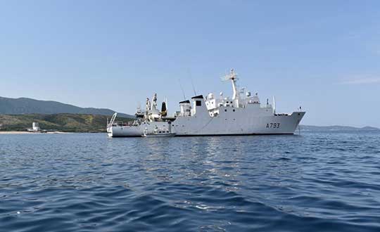
Shom’s fleet is based in Brest. It is composed of eleven boats, including seven speedboats, and three 59-meter long BH2 survey vessels. They operate on shallow and deep water in France, Africa, the Indian Ocean and in the Caribbean Sea. Shom also uses a fleet based in New Caledonia composed of two boats, one speedboat and a buoy-laying vessel used part of the time for hydrographic surveys.
French agency Shom’s survey vessel. (Photo: Shom)
Renewing the fleet. When it came to renewing the fleet’s INS, Shom looked at INS complying with standards set by the International Hydrographic Organization (IHO) for bathymetric surveys, with a focus on roll and heave that have the biggest impact on the multibeam echo-sounder data compensation.
After having conducted several tests in their official test zone where each element’s location is strictly and precisely known, Shom selected SBG Systems for replacement of its INS.
Shom first acquired a Navsight Ekinox (0.02° roll) for shallow-water survey in New Caledonia, and then decided to outfit the fleet in Brest with the Apogee (0.008° roll).
“The BH2 is highly versatile; it fits both deep and shallow water requirements. Having a homogenized fleet of sensors for speedboats and the BH2 is easier to maintain,” said Rémi Labonde, who is in charge of positioning and hydrographic equipment at Shom.
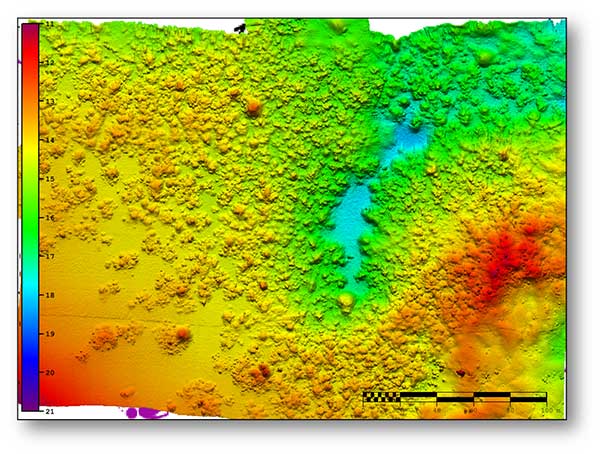
A seafloor survey conducted by Shom. (Image: Shom)
Navsight Apogee INS
Designed for hydrographers, the Navsight Apogee is composed of a GNSS receiver and a processing unit enabling real-time fusion of inertial and navigation data.
Navsight provides connections to external equipment such as echo sounders and computers. With its titanium enclosure, the Apogee sensor can be installed in the floodable engine compartment, close to the multibeam echo sounder.
Navsight marine solution. (Photo: SBG Systems)
Navsight Apogee is a high-performance cost-effective inertial navigation system based on state-of-the-art micro-electrical mechanical (MEMS) technology, and therefore requires no annual maintenance. The SBG solution includes free unlimited firmware updates and technical support.
Once connected through Ethernet, the Navsight web interface guides the installation. For example, a 3D view of the boat shows the entered parameters so that the user can check the installation in real-time.
The embedded filter also controls and validates lever arms and antenna alignment during this procedure, which can be a plus if the Shom needs to calibrate a new system abroad. “We are big fans of SBG’s web interface. It is modern, extremely clear, and easy to use; it really makes a difference in our team’s work,” Labonde said.
Qinertia post-processing software. Navsight Apogee INS accepts real-time corrections from real-time kinematic (RTK) or precise point positioning (PPP).
In its daily surveys, Shom uses PPP positioning, which doesn’t require installation compared to RTK. It also allows offshore surveying, or even near shore when no RTK correction is available.
SBG Systems’ in-house post-processing software Qinertia fixes data issues due to communication cut-outs. The onboard team checks the data and corrects it with Qinertia if needed.
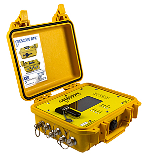
The NovAtel OEM6 GNSS receiver card used in the CEESCOPE echo sounder has been replaced with NovAtel’s latest low-power, high-performance OEM729 receiver.
With 555 channels, the new GNSS option brings a vast increase in available channels for future-proofing, improved interference rejection and better performance in challenging environments, the company said.
The TerraStar L-Band support remains.
The OEM729-equipped CEESCOPE is available with a built-in UHF radio modem and direct Ethernet connectivity to the GNSS receiver for NTRIP cell-phone real-time kinematic corrections.
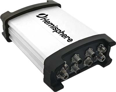
Hemisphere GNSS has introduced the Vector V1000 GNSS receiver for precision marine applications. The V1000 provides high-accuracy heading, position, pitch, roll and heave data.
The company made the announcement at the Oceanology International conference being held this week in London, U.K.
The V1000 supports multi-frequency GPS, GLONASS, BeiDou, Galileo, QZSS and IRNSS (with future firmware upgrade and activation) for simultaneous satellite tracking. The receiver is powered by Hemisphere’s Athena real-time kinematic (RTK) engine and is Atlas L-band capable.
The new V1000 is designed for professional marine applications, such as hydrographic and bathymetric surveys, dredging, oil platform positioning, buoys and other applications that demand the highest level 3D positioning accuracies. Based on Hemisphere’s Eclipse Vector technology, the V1000 uses the most accurate differential corrections including RTK and Atlas L-band.
The V1000 is Hemisphere’s flagship receiver, with an integrated display, that can be conveniently installed near the operator. The two antennas can be installed at user-specified separation, providing valuable flexibility in terms of install locations and desired heading accuracy.
The V1000 has heading accuracy of better than 0.01 degree when using a 10-meter antenna separation. With CAN, serial, Bluetooth, Wi-Fi and Ethernet support and flexible installation, the all-new rugged enclosure gives the V1000 the advantage of working reliably in harsh environments, the company said.
Fugro has been awarded six contracts by the National Maritime Safety Authority (NMSA) of Papua New Guinea. The hydrographic survey packages are expected to contribute to capacity development in the country, which has more than 5,000 kilometers of coastline.
The surveys will be conducted using a combination of Fugro’s Airborne Lidar Bathymetry (ALB) and multi-beam echo sounder (MBES) sensors, and a seamless dataset will be delivered to the NMSA.
“As a pioneer of ALB development, Fugro has a solid track record in applying this advanced technology for mapping shallow water environments safely and cost- effectively,” said Paul Seaton, Fugro’s regional business development manager for Asia Pacific.
The surveys in deeper waters will be performed by vessel, and Fugro will also conduct a comprehensive tides campaign throughout the survey area.
The contracts are part of the Asian Development Bank-funded Maritime Waterways Safety Project that aims to improve the safety and efficiency of the country’s international and national shipping in coastal areas and waterways. By improving the maritime environment and making coastal shipping safer, the project will facilitate travel, trade and tourism for rural communities.
Fugro has also begun a hydrographic survey encompassing an area of Norwegian waters of 15,000 square kilometers. The contract was awarded by the Norwegian Hydrographic Service and has a value of 34.5 million NOK (approximately €3.8 million).
The survey is part of the MAREANO program, for which Fugro has successfully completed a number of surveys since 2006. The Norwegian program maps depth and topography, sediment composition, contaminants, biotopes and habitats. It takes place in the Barents Sea with various areas located above the 78th parallel and typical water depths ranging from 80 to 3,500 meters.
Fugro’s laser airborne depth sounder (LADS) technology is being deployed in New Zealand to assist in relief efforts following the damaging 7.9 magnitude earthquake near Christchurch on Nov. 14.
At the request of the New Zealand Government, the Royal Australian Navy LADS flight is to conduct a rapid hydrographic survey of the seafloor in the coastal margins of the north east coast of the South Island.
“We will fly over the area and collect hydrographic survey data, which will reveal what has happened below the waterline, and identify any shifts in the ocean floor which mariners need to be aware of,” explained Flight Lieutenant Commander Susanna Hung, who is serving as the mission’s commanding officer.
The navy’s airborne lidar bathymetry (ALB) system has been developed by Fugro for safe, high speed and cost effective surveys of shallow coastal areas. Under a long-term contract to the RAN, Fugro provides the LADS technology, a de Havilland Dash 8-202 aircraft and support services.
Fugro’s LADS technology is being deployed following the Nov. 14 New Zealand earthquake.
The airborne survey equipment is operated by navy personnel from the main cabin of the aircraft to rapidly collect high resolution data of the seafloor. Fugro’s system incorporates sophisticated sensors that utilize a high-powered laser, innovative scanner and receiver optics technology.
The survey tool complements traditional hydrographic survey methods (such as hull-mounted multibeam echo sounders) to support nautical charting and coastal zone management applications in the nearshore/shallow water environment. The speed of deployment and safe operating capability make it an ideal solution to confirm the safety of navigation and locate new hazards such as is now required in the earthquake affected area.
“The New Zealand deployment by RAN LADS is an excellent example of how our innovative technology can assist in the safety of navigation and management of the marine environment,” said Paul Seaton, Fugro’s regional business development manager.
Fugro has been awarded a supply arrangement by the Canadian Hydrographic Service (CHS) to provide vessel-based hydrographic survey services. Under the contract, CHS will procure hydrographic surveys as needed, anywhere in Canada, to enhance its capacity for data acquisition and processing in support of its nautical charting program.
Hydrographic survey data from ports, harbors, nearshore and offshore regions will be acquired and processed using Fugro’s vessels, equipment and personnel. The resulting data will be used by CHS to update its nautical charts.
The supply arrangement, together with a supply arrangement for airborne lidar bathymetry (ALB) awarded in 2013, will enable Fugro to support Canada in its plans to implement an integrated multi-platform methodology to hydrographic surveying anywhere in Canada, including the Arctic region.
Fugro provides International Hydrographic Organization (IHO) compliant survey services to numerous governments throughout the world.
SBG Systems has released the Apogee-M and the Apogee-U, two inertial sensors, to complete the Apogee product line.
The Apogee-M is a motion reference unit (MRU), and the Apogee-U is an inertial navigation system (INS). Both are made of titanium with a depth rating of 200 meters.
Apogee Series is an accurate INS based on robust micro-electro-mechanical systems (MEMS) technology. One year after the successful release of Apogee surface sensors (IP68 enclosure), SBG Systems completes the product line with the two inertial sensors, which have titanium subsea enclosures (200-meter depth rating).
Accuracy. Apogee integrates the latest generation of MEMS sensors to reach a high degree of precision — 0.008 degrees in roll and pitch in real-time — while delivering a robust and accurate heading from the continuous fusion of GNSS and IMU data. Made of titanium, Apogee-M and Apogee-U are designed to mount close to the sonar head for hydrographic tasks from shallow to deep water.
Heave computation. The Apogee provides a real-time heave accurate to 5 centimeters, which automatically detects the wave frequency and constantly adjusts to it. When wave frequency is erratic or in case of long period swell, the delayed heave feature can save the day by allowing survey in rough conditions. This algorithm allows a more extensive calculation, resulting in a heave accurate to 2 cm displayed in real-time with a short delay.
Connects to survey-grade GNSS receivers. Apogee sensors can be paired with any type of survey-grade GNSS receiver or with the one offered by SBG Systems. The SplitBox GNSS integrates the latest tri-frequency GNSS receiver to offer several positioning features such as RTK, Marinestar, OmniSTAR, Veripos and TerraStar corrections.
Configuration is acomplished throughout the intuitive, embedded web interface where all parameters can be quickly displayed and adjusted. The new 3D View helps the user check the mechanical installation, especially sensor and antennas position, alignments and lever arms. The user can then connect the Apogee to the main hydrographic software such as Hypack, QINSy or Teledyne PDS2000, thanks to available drivers.
The MEMS technology is renowned for being highly robust and low-maintenance, while the subsea enclosure is made in titanium. SBG SYSTEMS continuously make its systems evolve with new firmware upgrades that are available during the whole life of the product without extra cost.