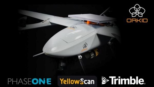
Drone-maker Orkid has unveiled a new variant of its Orkid 260 drone that incorporates four technologies to improve aerial data-capture technology.
According to the company, the Orkid 260VTOL represents a leap forward in the integration of advanced sensing and communication technologies, setting a new benchmark for multi-mission drone capability across commercial and industrial applications. The company said it is the “first vertical take-off and landing (VTOL) drone to bring all four of the most advanced aerial data capture technologies together — onboard, fully integrated, and operating simultaneously.”
The system combines lidar (YellowScan Surveyor Ultra), photogrammetry (Phase One P5 camera), GNSS/IMU (Trimble Applanix APX-RTX), and Starlink satellite communications integration in a single platform.
Built on a 100% electric, NDAA-compliant architecture, the aircraft delivers an estimated 1.5 hours of flight endurance with a range of up to 75 miles. Designed for mapping, surveying, utilities, oil and gas, defense, and critical infrastructure inspection, the new model expands the operational scope for high-precision, long-range missions.
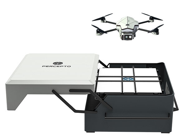
Percepto Air Mobile drone with base. (Photo: Percepto)
Percepto, an Israel-based company specializing in autonomous inspection with industrial robotics, has launched its 2022 Autonomous Inspection & Monitoring (AIM) platform and Air Mobile drone.
Recently listed in TIME magazine’s 100 Best Inventions of 2021, Percepto offers an end-to-end solution powered by artificial intelligence (AI) to collate and streamline all visual data for accurate actionable insights.
Percepto AIM 2022 has a new Insight Manager to deliver AI-powered packaged solutions for sector-specific use cases, such as solar, mining, energy, oil and gas and other industries. The company drew on tens of thousands of hours collected by autonomous robot missions at industrial facilities to create it.
Percepto’s AI change-detection framework offers unified visual data and critical business insights for each of the sector-specific solutions. AIM 2022 can be integrated with autonomous drones and robots as well as other visual data collectors, now including DJI drones, and fixed cameras.
Reports and insights are automatically generated based on the combined visual data. Disseminated to relevant stakeholders on any mobile device, issues and faults are geotagged and displayed on a map, enabling effective action before escalating into more serious problems.
Percepto also introduced its new Percepto Air portfolio to support the enhanced platform, which will address the diverse needs and increasing demands of various markets.
Percepto Air Max. The next generation of Percepto Sparrow, the Percepto Air Max is a field-proven solution that operates in the largest mining, oil and gas, and energy companies on six continents. It has a top-grade, versatile payload for specific use cases. Designed to inspect and map complex industrial environments where the highest accuracy and durability are critical, Air Max also has an optical gas imaging (OGI) camera.
Percepto Air Mobile. This option is a more compact and lighter weight model for smaller sites or organizations taking their first steps with a drone-in-the-box program, or larger sites that need greater deployment flexibility. It is designed for linear inspections, such as pipelines and power lines, and can monitor short-term projects across multiple sites, such as construction sites.
Percepto Air Max and Air Mobile drones are stored permanently onsite within their respective Percepto Bases. The Air Mobile’s base is light and easy to relocate while maintaining high levels of durability. These encasements are designed for infrequent maintenance and protection against extreme environmental phenomena, such as hurricanes. Percepto’s drones are safe and regulation ready, and ensure all operational aspects meet corporate standards.
“Percepto AIM 2022 and the new Percepto Air line of drones, together with the most advanced change detection solution, alert and prevent failures and downtime within diverse use cases across many industries,” said Percepto CEO Dor Abuhasira. “Percepto AIM provides the most advanced and comprehensive enterprise inspection software that offers a complete data workflow — from capture to insight. With Percepto Air Max and Percepto Air Mobile, companies have a range of options to choose from depending on the size of their facilities and the flexibility needed to deploy drones.”
“The real power of Percepto’s system is how data collection and analytics are integrated for a holistic view from both a technical and management perspective,” said Tim Shanfelt, director of Operations Transformation, Koch Ag & Energy. “Our workers are connected to high-level information that helps them make the right decisions while keeping them safe and free to pursue higher value activities. Our goal is to eliminate hazardous, wasteful, and mundane tasks from our operators’ day. For example, instead of an employee climbing an icy ladder in the winter, a robot or drone can perform the same task while still obtaining accurate measurements. We see Percepto playing a significant role in helping make our facilities more safe, secure, efficient, and profitable.”
Hitec Commercial Drone Services expects to provide training, precision aerial missions and comprehensive data collection to a variety of industries, including
agriculture, construction, excavation, mining and aggregates, oil and gas, engineering and surveying, public safety and many other vertical sectors. Hitec maintains a fleet of unmanned vehicles. It offers proprietary mission-control software and data and photogrammetry collection techniques with its comprehensive unmanned aviation experience.
The new division’s field services director is Jim Bonnardel, an innovative entrepreneur with a history steeped in unmanned flight. Bonnardel established his own successful business in 1982, providing aerial services to business-to-business entities. His inventive nature and extensive flying prowess led him to become a certified and insured UAS service pilot and instructor.
Bonnardel has logged more than 1,750 precision mapping missions, inspected 2,000 utility structures, and flown more than 2,500 commercial and residential property shoots, as well as dozens of missions for creative projects involving both television and music videos.
He is also an instructor at Grossmont College in El Cajon, California. He has provided 850 hours of commercial instruction, as well as 550 hours of instructional field training and vetting for utility inspection crews. As a result of his training experience, Jim has issued 150 sUAS Utility Training Certificates.
Japan-based Terra Drone’s newest branch, Terra Drone Australia, will focus on the mining, oil and gas, power and forestry sectors.
Terra Drone Corporation, an industrial drone services provider headquartered in Tokyo, has finalized its expansion into the Australian market after completing an equity investment in Australian firm C4D Intel Pty Ltd. As part of the deal, C4D Intel will immediately rebrand to Terra Drone Australia.
The move by Terra Drone is the latest of the company’s investments into drone technology businesses across the globe and demonstrates the Japanese company’s commitment to the Australian market. The terms of the transaction were not disclosed.
Founded in 2016, C4D Intel provides surveying, inspection and 3D modeling services to a diverse client base across mining, oil and gas, power and forestry industries in Western Australia.
The company specializes in large-scale unmanned aerial surveys, confined space infrastructure inspections, high-altitude inspections, bridge and pipeline inspections, and asset 3D modeling.
As Terra Drone Australia, the company will be able to leverage the additional growth capital to expand its service offering to include unmanned airborne lidar, bring innovative Terra Group technologies to Australia, and expand its operations to the East coast of Australia, Terra Drone stated in a press release.
The Australian drone service provider’s existing clients include mining companies Rio Tinto and Fortescue Metals Group, and large utilities such as ATCO Gas Australia and Synergy.
“We are delighted to join the No.1 industrial drone services company in the world, Terra Drone. When the world’s fastest-growing drone business chooses to expand to Australia, and selects our business to invest in, it speaks volumes about the opportunities available here and the vision we have for the company,” C4D Intel Operations Manager Will Wishart said.
“There are many advantages of being a part of a global organization and this next phase of growth makes for very exciting times. We have already leveraged Terra Drone’s international network to bring new technology to Australia and look forward to accelerating this as we expand our operations across the Australian continent.”
Terra Drone Corporation CEO Toru Tokushige added, “The establishment of Terra Drone Australia is another milestone for our international expansion strategy. Australia bears a strategic significance in our growth plans. Having a local presence in the region allows us to be close to our customers and strengthen our support to them.”
Later this month, Terra Drone Australia will bring innovative drone technology from The Netherlands to Australia for proof-of-concept trials for global mining company Rio Tinto. The Terra UT Drone from Terra Inspectioneering will allow Terra Drone Australia to offer ultrasonic thickness testing of steel in hard to reach places, such as bin walls which are subject to wear.
Planet’s Deven Desai explains how Planet uses satellite imagery to uncover data for the oil and gas industry, as well as for road detection, at the 2019 Esri User Conference in San Diego.
Topcon releases upgrade of MAGNET software suite with new features and organization.
Topcon Positioning Group released the newest edition of its suite of software solutions — MAGNET 5.1. The upgrade is packed with new features, modules and support, as well as a reconfiguration of the Office portfolio designed for simplicity.
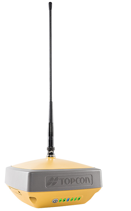
The HiPerVR GNSS receiver. (Photo: Topcon)
New updates to MAGNET Field include support for the new HiPer VR GNSS receiver, a piping and trenching module with new capabilities specifically for the oil and gas segment, as well as the ability to orient and scale a PDF directly on a field controller and set it as a background image.
“The new piping and trenching module greatly improves the COGO, mapping, and exchange functions for in-field oil and gas pipeline design and construction,” said Jason Hallett, vice president of global software business development at Topcon. “Simplified workflows deliver an alignment, profile, and cross-section set for loading into 3DMC for pipe trench excavation. Additionally, customers can now import a PDF drawing as a background image in MAGNET Field. Simply set the insertion point and then rotate and scale by selecting points or lines,” said Hallett.
New additions to MAGNET Office include a reconfiguration of the portfolio, designed for simplicity, integrated workflows and better service plans. The service plans and subscriptions for MAGNET Office now include MAGNET Enterprise, license check-in and check-out, direct email support and an eLearning fundamentals course.
Additionally, the E-commerce user-experience has been greatly improved with a new webstore. Direct email user support is currently offered at this web address.
“The newly optimized product portfolio allows customers to easily select the appropriate Office software product best for their common project demands. The new office structure includes five main products named: project, construction, site, survey and layout, which are consolidated packages of the various MAGNET software services for ease of use and bundling.
“MAGNET Site, MAGNET Construction, and MAGNET Project now include all of the Viasys VDC Modeler and Explorer functionality for infrastructure BIM modeling and visualization, and MAGNET Project adds even more power by including the DynaRoad mass-haul modules Plan, Schedule and Control,” said Hallett.
Additionally, MAGNET Enterprise now offers concurrent login to MAGNET Field, Enterprise and Office with a single set of login credentials.
SkyX Systems Corporation has successfully completed an unmanned data-collection flight of 100 kilometers (km), one of the longest journeys in its class.
The firm flew its SkyOne unmanned aerial system (UAS) on an autonomous data mission over more than 100 km of gas pipeline in Mexico. The robotic flight was programmed and monitored remotely from the company’s Greater Toronto Area SkyCenter mission control, with a support crew of engineers on the ground in Mexico.
Using high-resolution imagery, the longest of multiple flights identified more than 200 potentially significant anomalies along the remote pipeline, ranging from unauthorized buildings and cultivation, to a fissure possibly caused by seismic activity.
More than $38 billion is spent annually monitoring oil and gas pipelines using less efficient means. The SkyX System flight gathered data in a little more than an hour that would have taken a person well over a week. It identified more than 200 georeferenced anomalies the customer was unaware existed, pinpointing precise coordinates for rapid investigation and remediation.
The SkyX System consists of a vertical takeoff and landing (VTOL) drone, the SkyCenter control room, which allows for real-time and secure mission monitoring from remote locations, as well as the company’s proprietary SkyBoxes that enable SkyOne to recharge and continue long-range missions without having to return to home, a factor that limits many drones.
Using the system, a client doesn’t need a trained pilot to operate a remote-control unit — the entire mission is programmed and carried out autonomously, from takeoff to landing. Plus, the VTOL drone eliminates the need for runways, launchers or capture devices.
Pergam gas sensor aboard the Microdrones md4-1000 UAV.
The professional aerial methane detector mdTector1000 CH4 from Microdrones makes it easy to detect methane gas via a fully integrated aerial package for professionals responsible for methane gas infrastructure.
The mdTector1000 CH4 has a Pergam gas sensor, mounted and integrated with the Microdrones md4-1000 UAV. In real time, users can see aerial shots of detection with the laser sensor, the company said. The carbon-fiber built UAV goes into dangerous areas unsuitable for workers.
The mdTector1000 CH4 can be used for natural gas line surveys, tank inspections, gas well testing, plant safety and landfill emission monitoring.
The mdCockpit Android App allows users to maintain visualization in flight. A special mdTector app allows users to visualize and present all post-flight data on one map.
OnTerra Systems has introduced a new version of its MapSavvy aerial imagery service and a corresponding new website, www.MapSavvy.com.
MapSavvy is an affordable Web Map Service providing OGC-compliant images for anyone who needs aerial images in the course of their work or research.
The new version of MapSavvy offers users access to two versions of Bing Maps aerial imagery: original Bing Maps imagery and the recently updated aerial imagery updates introduced in 2017.
Typical users of MapSavvy are GIS and CAD professionals from business, research, or government organizations that need to use aerial imagery as part of projects, presentations, reports, or visual analysis of trends.
Examples of MapSavvy users include:
Architects and developers: Architects and developers use MapSavvy in GIS and CAD applications to obtain aerial imagery of construction sites to incorporate into projects, proposals and presentations that show where new buildings or structures would be located in the context of an existing built environment.
Research teams: Research teams use MapSavvy in GIS and CAD applications to access aerial imagery that will be incorporated into research reports, or to be able to spot trends by visually depicting information on top of an aerial image. MapSavvy is used for wildlife tracking, hydrology, environmental programs and a host of research activities.
Public safety: Law enforcement teams use MapSavvy to access base map where crimes are occurring, either to spot trends or to help solve a specific criminal case.
City planning: City planners use MapSavvy to see base map aerial views of cities, municipalities and unincorporated areas as part of their process of planning city infrastructure and new developments.
Oil and gas: Oil and gas companies use MapSavvy in GIS and CAD applications to view aerial imagery to plan for pipeline facilities placement.
The new MapSavvy aerial imagery service offers the flexibility of access to original Bing Maps imagery as well as the new updated aerial imagery introduced in 2017. The original Bing Maps imagery offers the highest resolution. The newly updated Bing Maps imagery offers the most up-to-date imagery of developed areas that have undergone changes to streets and buildings, or wild land areas that have seen changes due to geological shifts or wildfires.
“By offering MapSavvy users access to the original Bing Maps imagery and the new updated imagery, users get the best of both worlds,” said Steve Milroy, OnTerra Systems president. “This new version of MapSavvy lets users access original Bing Maps imagery if their application requires high-resolution images, or access recently updated Bing maps imagery if they require the most up-to-date images showing changes to cityscapes or wild lands.”
Honeywell has launched its first commercial unmanned aerial vehicle (UAV) inspection service — the Honeywell InView inspection service — to help industrial customers improve critical structure inspections while helping increase employees’ safety from many of the risks associated with these often-dangerous working conditions.
Intel Falcon 8+ octocopter drone.
The Honeywell InView inspection service will combine the proven performance of the Intel Falcon 8+ UAV system and Honeywell’s expertise in the aerospace and industrial industries with data-driven software customized to the needs of the utility, energy, infrastructure, and oil and gas industries, the company said.
The Honeywell InView inspection service package, which includes the components of the UAV, pilot app and customizable web portal, helps customers organize and create standards around their routine and crisis-response inspections.
For example, the Honeywell InView inspection service can help utility customers create routine inspections of transmission and distribution systems that generate data that can be stored, searched and accessed from in the office and out in the field on demand.
“This collaboration combines Intel’s advanced commercial Intel Falcon 8+ UAV system with Honeywell’s leadership in aerospace safety and connectivity to deliver solutions that deliver reliable, efficient and actionable information to utility and industrial customers,” said Carl Esposito, president, Electronic Solutions, Honeywell Aerospace. “Through our extensive industrial experience, our customers will also gain access to Honeywell’s customized software and data solutions that will help them log, analyze, and eventually predict or prevent outages and structural failures, while protecting the men and women called upon to complete these crucial but high-risk jobs.”
“We are incredibly pleased to collaborate with Honeywell on this exciting new business opportunity,” said Anil Nanduri, general manager for Intel’s UAV business group. “The safety, flight precision and robust performance of the Intel Falcon 8+ system are a perfect fit for the Honeywell InView inspection service and will allow its customers to inspect, collect and analyze valuable data in a whole new way.”
With Honeywell’s InView inspection service, customers tap into Honeywell’s experience across vertical segments such as utilities, aerospace, connected building management, and oil and gas technologies.
In collaboration with Intel, Honeywell will utilize the intelligence and experiences of its diverse set of businesses to give customers a comprehensive solution and experience unrivaled in the marketplace.
“Technology, along with the Internet of Things, is enabling utilities around the world to modernize the management of their energy grids,” said Nitin S. Kulkarni, president, Smart Energy, Honeywell Home and Building Technologies. ” Honeywell brings together the technology that allows utilities to transform how energy is consumed in homes and buildings with software-based systems that help safely and efficiently manage complex industrial facilities and utility grids. Honeywell also has more than 100 years of experience providing dependable products and services to a variety of industries, of which Honeywell InView inspection service is the latest entry.”
Inspection Service goals
Keeping workers safe. According to the U.S. Department of Labor, utility line workers have one of the top 10 most dangerous jobs in the United States, with 21.5 annual fatalities from high-voltage lines for every 100,000 workers.
By using the inspection service, utility companies can send a UAV to perform routine inspections of substations, transmission towers and power lines while keeping boots on the ground and workers safe.
For utilities, using a UAV for inspections offers safer and more cost-effective means than existing methods using helicopters, cherry pickers, ladders and walking inspections.
Improving efficiency. Historically, inspections are siloed by organization and by individuals within organizations. Honeywell’s InView inspection service aims to create standardized inspections where customers can create operational efficiencies in the office and out in the field.
Data capture and analysis. UAVs are being touted for their data-gathering capabilities, but without analytics, more data is simply more data. Honeywell’s service can synthesize vast quantities of data to identify only what is needed and actionable, translating workers’ tacit knowledge into valuable information that provides actionable insights for business.
Connected Freight
Honeywell and Intel also recently collaborated to create a Connected Freight platform that gives shippers and logistics companies the unprecedented ability to monitor shipments of high value and perishable goods, helping prevent costly damage and loss.
The new Honeywell InView inspection service continues the work these two companies are doing to help various industries use connected devices to be more efficient and safer, and harness data in new and meaningful ways.
TCarta Marine, a global provider of marine geospatial products, will unveil two new offshore data offerings at the 2017 Esri Petroleum GIS Conference in Houston — the Gulf of Mexico Marine Basemap Plus service and 2-meter Satellite Derived Bathymetry dataset.
The Marine Basemap Plus is a streaming data service that delivers up-to-date value-added marine layers directly into Esri ArcGIS on a subscription basis.
The 2-meter Bathymetry product is an off-the-shelf shallow water, coastal zone bathymetric dataset derived from high-resolution satellite imagery.
Both products will be demonstrated by TCarta Marine in booth #403 at the Esri Petroleum Conference being held April 12-13, in Houston’s George R. Brown Convention Center.
“The Marine Basemap service covering the entire Gulf of Mexico is available now,” said TCarta Marine President Kyle Goodrich. “Datasets for additional marine regions around the world will be added this year with the North Sea available this summer.”
The streaming data service was developed with the oil and gas industry in mind, allowing customers to choose from two subscription tiers for the Gulf of Mexico. The GoM Marine Basemap is a tiled map service intended to provide users with an informative and aesthetically pleasing backdrop streamed into the desktop GIS environment. The Basemap is a scale-dependent display of a stylized bathymetry image with labeled contour lines and marine feature names
The Marine Basemap Plus incorporates best-available resolution bathymetry grids, contour lines and other valuable data for modeling, analysis and derivative work. The entire gulf is covered at 90-meter resolution while many areas have been mapped at 30-meters, with higher resolution data to be added.
“Marine Basemap Plus will appeal to oil and gas companies of all sizes because the streaming data is extremely affordable and updated constantly through the subscription process,” said Goodrich. “The GIS manager at an energy company will never have to worry about obtaining the most recent or highest quality offshore data because it will be downloaded automatically.”
The Gulf of Mexico Marine Basemap Plus also includes information enhanced from authoritative sources such as the National Oceanic and Atmospheric Association (NOAA), National Ocean Service, Department of Energy and Bureau of Energy Management. The five main value-added layers relate to:
Navigation – Seafloor elevation data including dredged channels and shipping lanes
Geology – Natural features and seismic anomalies
Lease Blocks – Active leases, well, and pipeline information
Habitat – Reefs, grasses, corals and other marine ecosystems
Shoreline – Vector derived from lidar and satellite imagery
Also making its U.S. debut at the Esri Petroleum show will be the 2-meter Satellite Derived Bathymetry offering developed by TCarta Marine, DHI and DigitalGlobe with funding from the European Space Agency. This is an off-the-shelf version of a custom product introduced in 2011 by Proteus Geo, which merged with TCarta Marine this year. It will eventually be a global marine dataset.
To create this product, accurate seafloor depths are extracted by DHI using a primary production technique before TCarta Marine ensures that all data undergoes a rigorous quality control procedure. All depths are derived from eight-band multispectral imagery captured by DigitalGlobe’s high-resolution WorldView satellites, the commercial imaging constellation.
“This process derives bathymetric measurements at 2-meter resolution to an average depth of 20 meters in the near-shore coastal zone, where environmental conditions allow,” Goodrich said. “The 2-meter product will be sold by the square kilometer, which means clients only pay for the data they need, making this a very cost-effective product.”
The off-the-shelf 2-meter product covering the Arabian Gulf is available for purchase now, with the Red Sea planned for completion by later this year. By mid-2017, TCarta Marine will make the 2-meter products available for instant searching, purchasing and downloading through an online portal called Bathymetrics.
The Gulf of Mexico Marine Basemap Plus and 2-meter Bathymetric products can be ordered through [email protected].
LandWorks Inc., a developer of innovative land management solutions, has improved its Web AutoMapper online service that translates land legal descriptions into GIS-ready map polygons.
The updated Web AutoMapper features a new interface that is easier to use, including a job detail webpage that lets users review and edit polygons before purchase. Clients can now have their property polygons mapped against USLandGrid’s national land base, with the option of buying land grid townships containing the mapped property.
“These changes make the Web AutoMapper even easier and more cost effective to use,” said LandWorks President Jerry Bramwell. “Anyone with a need to create land maps can do so in just a few minutes at minimal cost.”
For about 20 percent of the cost of manual mapping, Web AutoMapper has simplified land records mapping in the oil and gas, renewable energy, mining, banking, utility, pipeline, state/local government, telecommunications, transportation, water and real estate sectors. The cost to map a legal parcel description with Web AutoMapper is $2 per polygon with the USLandGrid offered at $7 per PLSS Township.
“The USLandGrid data provides the tie between a legal description and the geography of that parcel of land,” said USLandGrid Vice President of Sales Anthony Ford. “Producing polygons this way allows you to get your land positions on a map for critical analysis using the GIS.”
“LandWorks selected USLandGrid for inclusion in Web AutoMapper because it is the best basemap available for any industry or profession to use in mapping property legal descriptions,” said Bramwell. “An important benefit of the USLandGrid is that its data layers are continuously updated as more accurate survey data becomes available.”
LandWorks first introduced Web AutoMapper in 2013 as an inexpensive, fast and easy method of processing many types of standard property descriptions and converting them into digital map polygons. Legal descriptions that would take days or weeks to map manually can be processed in minutes with this online software-as-a-service application.
A customer simply logs onto Web AutoMapper and creates an account. The user then submits an Excel spreadsheet containing one or hundreds of legal descriptions in Jeffersonian Township/Range or Texas Survey/Abstract formats. Within seconds, Web AutoMapper provides an onscreen report detailing which polygons can be generated, which cannot, and shows an overview of the mapped polygons aligned to the USLandGrid.
If the customer decides to proceed, a credit card is provided. For customers who don’t already own the Grid, they have the option of buying it by the township along with their mapped polygons.
Web AutoMapper generates a zip file of the purchased polygons and USLandGrid townships either in Esri shapefile or file geodatabase format in NAD 83 or 27 for direct download into Esri ArcGIS software as well as other popular mapping systems, such as IHS Petra, IHS Kingdom and LMKR GeoGraphix.
As a cloud-based application, Web AutoMapper brings the full power of the standalone LandWorks AutoMapper software to every level of digital map user via the Internet. Introduced in 2002, the onsite AutoMapper package is purchased by an organization and sits behind their firewall as a production-grade GIS mapping tool. The software is used extensively by organizations that own or lease many land rights and must keep their property records up to date, such as local governments, energy companies and natural resource management entities.