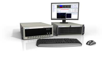
Spirent Communications, now part of Keysight Technologies, announced PNT Xe, a GNSS simulation platform designed to expand high-performance GNSS testing across the development lifecycle. The platform aims to reduce barriers to positioning, navigation and timing testing by offering simulation capabilities in what the company describes as an economical, multipurpose platform.
The company said PNT Xe addresses challenges manufacturers face in validating GNSS performance during accelerated development schedules. The platform’s hardware supports testing from early prototypes through production line verification for commercial and military applications.
“Until now, many organizations have been forced to use unreliable, inconsistent simulators or utilize ‘live sky’ signals as a way of conducting production testing,” said Peter Terry-Brown, divisional CEO of Spirent’s positioning business. He said PNT Xe makes the company’s simulation technology available for workstations, engineers and project phases.
Terry-Brown said the platform allows developers, integrators, design verification teams and production line testers to use consistent test methodology without compromising results validity. Many leading GNSS chipsets and modules are developed using Spirent’s simulators, he said.
The compact PNT Xe can be rack or desk mounted and features an interface designed to accelerate scenario creation. The platform can operate in lab or field environments and withstand variations in temperature and vibration while maintaining performance, according to the company. It supports all GNSS constellations and frequencies and includes AES M-Code access and a removable system disk for secure testing environments.
Rob VanBrunt, CEO of Spirent Federal Systems, called PNT Xe “a game-changer for defense customers.” He said the platform’s ease of use will help deploy new PNT technology faster, allowing software engineers to test code changes at their desks. Authorized GPS M-Code users can conduct unclassified military signal testing using AES M-Code without relying solely on secure labs, he said.
Marie Hattar, chief marketing officer at Keysight Technologies, said accurate, high-performance simulation becomes critical as positioning and timing technologies become foundational to 6G, defense systems and autonomous vehicles. PNT Xe makes that capability available to more innovators to validate performance, reliability and resilience at every development stage, she said.
Built on Spirent’s 40 years of expertise, PNT Xe is designed for development and production environments including low-altitude drones, vehicles, space applications, automotive, defense, and consumer devices.
[SPONSORED CONTENT] As developers look beyond GNSS alone to address increasingly complex positioning challenges, PNT X brings together signals including L-band, S-band, and alternative navigation signals, as well as industry-first Regional Military Protection (RMP) support, into one innovative, compact, and flexible system.
PNT X brings together the broadest set of features and capabilities needed to protect future systems. These include the patented I/Q spatial awareness capability, an enhanced controlled reception pattern antenna (CRPA) testing interface, the highest available continuous dynamic range for jamming evaluation, and a standard update rate of 2 kHz for hardware-in-the-loop (HIL) and high-dynamics vehicle testing. Along with a host of other groundbreaking enhancements, these make PNT X the world’s most advanced test solution for NAVWAR robustness. Most importantly, it can do all this with simulation integrity delivering trusted results.
When Boston Light — an 89 ft-high, white lighthouse on Little Brewster Island in Boston’s outer harbor — opened in September 1716, it was the first one in the Thirteen Colonies. Sally Snowman, who has been its keeper for most of the past two decades, is the last official lighthouse keeper in the United States. Contemplating the horrible trips across the Atlantic on merchants’ galleons, when many gale-tossed passengers despaired of ever setting foot on land again, she recently commented: “Imagine what they felt when they spotted the light.” See Dorothy Wickenden’s article “Last Watch” in the November 6, issue of my favorite magazine, The New Yorker. Of the roughly 850 lighthouses currently in the United States, Wickenden reported, only about half serve as active aids to navigation and the U.S. Coast Guard has automated all of them. “The rest,” Wickenden wrote, “have been made obsolete by GPS.” Yet, she pointed out, even hardheaded ship captains and pilots say that “lighthouses still have a place.”
When Snowman retires at the end of this month, it will mark the end of an era that lasted more than three centuries. This month also marks the 50th anniversary of the approval of Navstar GPS (as it was originally called) by the Defense Systems Acquisition Review Council (DSARC) of the U.S. Department of Defense. Three months earlier, at the meeting now remembered as Lonely Halls (see my editorial in the September issue), Brad Parkinson and his team had made the key decisions about the system’s architecture, including the number of satellites, their orbits, and what kinds of signals to use.
In this month’s issue, we revisit how, after initial opposition, the U.S. armed forces adopted GPS; how the civilian/commercial GPS (now GNSS) industry was born; and how surveyors reacted to this disruptive new technology.
To answer the first question, I asked Gaylord Green, who was on Parkinson’s team and later led the GPS Joint Program Office, to write his recollections on the subject. I also interviewed Marty Faga, whose long and distinguished career included four years as both Director, National Reconnaissance Office and Assistant Secretary for Space, U.S. Air Force. Faga passed away on October 19. To answer the second question, I turned to Charlie Trimble, who in 1978 co-founded the company named after him and was its CEO until 1998. To answer the third question, I chose Dave Zilkoski, who earned a master’s degree in geodetic science in 1979, the year after the first GPS satellite was deployed, while working for the National Geodetic Survey, of which he was later the director for about three years. Many readers of this magazine also know Zilkoski as the regular contributor to one of our four digital newsletters, Survey Scene.
Advanced industrial societies are increasingly reliant on the fantastic capabilities of global navigation satellite systems (GNSS) — GPS, GLONASS, BeiDou and Galileo — and, therefore, increasingly vulnerable to their weaknesses. From providing our position on a map on our smartphone to timing financial transactions, cell phone base stations, and the internet; from steering tractors in the field to guiding first responders; from giving surveyors sub-centimeter accuracy to monitoring continental drift; from providing navigation to ship captains and airplane pilots, to enabling automated control of earth moving machinery, GNSS have become a critical infrastructure. Yet their well-known vulnerabilities — such as jamming, spoofing, multipath and occultation — continue to fuel the development of complementary sources of positioning, navigation and timing (PNT) data, especially for new and rapidly expanding user segments such as autonomous vehicles.
In a January 2021 report, the U.S. Department of Transportation pointed out that “suitable and mature technologies are available to owners and operators of critical infrastructure to access complementary PNT services as a backup to GPS.”1
Several new PNT systems are being developed and deployed that are partially or entirely independent of the four existing GNSS constellations. This cover story focuses on the following companies, products and services:
Safran Federal Systems (formerly Orolia Defense & Security) makes the VersaPNT, which fuses every available PNT source — including GNSS, inertial, and vision-based sensors and odometry. I spoke with Garrett Payne, Navigation Engineer.
Xona Space Systems is developing a PNT constellation consisting of 300 low-Earth orbit (LEO) satellites. It expects its service, called PULSAR, to provide all the services that legacy GNSS provide and more. I spoke with Jaime Jaramillo, Director of Commercial Services.
Spirent Federal Systems and Spirent Communications are helping Xona develop its system by providing simulation and testing. I spoke to Paul Crampton, Senior Solutions Architect, Spirent Federal Systems as well as Jan Ackermann, Director, Product Line Management and Adam Price, Vice President – PNT Simulation at Spirent Communications.
Satelles has developed Satellite Time and Location (STL), a PNT system that piggybacks on the Iridium low-Earth orbit (LEO) satellites. It can be used as a standalone solution where GNSS signals will not reach, such as indoors, or are otherwise unavailable. I spoke with Dr. Michael O’Connor, CEO.
Locata has developed an alternative PNT (A-PNT) system that is completely independent from GNSS and is based on a network of local ground‐based transmitters called LocataLites. I spoke with Nunzio Gambale, founder, chairman, and CEO.
Due to the limited space available in print, this article only uses a small portion of these interviews. For full transcripts of them (totaling more than 10,000 words) click here.
1 Andrew Hansen et al., Complementary PNT and GPS Backup Technologies Demonstration Report, prepared for the Office of the Assistant Secretary for Research and Technology, Department of Transportation, January 2021, p. 195.
Locata dish antenna pointed to the European Union’s Joint Research Center in Ispra, Italy, 44 km away, just under the setting sun. The Yagi antenna above is pointed to a cell tower in Como and used to connect the system for remote control and data logging. (Image: Locata)
Complementary PNT
“Traditionally, augmentation to GNSS has been done through inertial navigation systems (INS),” Price said. “More recently, ground- and space-based augmentation systems have increased in usage. However, both technologies depend on the absolute positioning information provided by GNSS. They do not represent a true alternative PNT.”
To facilitate the development of advanced and autonomous applications, Price suggested incorporating terrestrial sources of PNT as well as ones based on LEO, medium-Earth orbit (MEO) and geostationary equatorial orbit (GEO) satellites. This, he added, would also keep costs from becoming prohibitive. “LEO brings many benefits in comparison to MEO in just about every industry to which it can be applied,” Jaramillo said.
While mass reliance on GNSS facilitates access to GNSS data and makes devices that use it increasingly cost-effective, over-reliance on a single sensor is risky, Austin pointed out.
“That’s where complementary PNT comes in: if you can put your eggs in other baskets, so you have that resilience or redundancy, then you can continue your operation — be it survey, automotive or industrial — even if GNSS falls or is intermittently unavailable or unavailable for a long time,” Austin said.
It has been said that “the only replacement for GNSS is another GNSS.” Inertial navigation, dead reckoning, lidar, and referencing local infrastructure that, in turn, has been globally referenced using GNSS, enable mobile platforms to maintain relative positioning during GNSS outages. However, absolute positioning will continue to require GNSS. “If you claim to be breaking free from GNSS you’re really saying, ‘I can navigate in this building, but I don’t know where this building is,’” Austin said.
GNSS-INS Integration
GNSS and INS have always been natural allies because they complement each other. The recent completion of the BeiDou and Galileo constellations, which has greatly increased the number of satellites in view, has made the requirement for six satellites at any one time for real-time kinematic (RTK) “a much more reasonable proposition,” Austin said. Coupled with the drop in the price of inertial measurement units (IMU), this has made it possible to “make a more cost-effective IMU than ever or spend the same and get a much better sensor than you ever could before,” he said. “Your period between the GNSS updates is also less noisy and you have less random walk and more stability.”
It used to be that the performance of an accelerometer might far outweigh that of a gyroscope, resulting in excellent velocity but poor heading. “Now,” Austin said, “we can pick a much more complementary combination of sensors and manufacture and calibrate an IMU ourselves while using off-the-shelf gyroscopes and accelerometers. That allows us to make an IMU that is effectively not bottlenecked in any one major area.”
Autonomous vehicles require decimeter accuracy to keep to their lane, while their absolute position is irrelevant to that task. It is, however, essential for map navigation and to know about infrastructure such as traffic signs and stoplights that may not be in a vehicle’s line of sight.
“That’s where the global georeferencing comes in and where GNSS remains critical,” Austin said. “One of the key things we’re examining is GNSS-denied navigation: how we can improve our inertial navigation system via other aiding sources and what other aiding sensors can complement the IMU or inertial measurement unit to give you good navigation in all environments. Use GNSS when it’s good, don’t rely on it when it’s bad or completely absent.”
Nowadays, car makers are increasingly moving their research and development tests from indoor, controlled environments to open roads. Therefore, “they are looking for a technology that allows them to keep doing those tests that they did on the proving ground, but in real world scenarios,” Austin said. “So, they rely on the INS data to be accurate all the time. In autonomy and survey, on the other hand, the INS is used actively to feed another sensor to either georeference or, in the case of autonomy, actively navigate the vehicle. So, that data being accurate is critical because an autonomous vehicle without accurate navigation cannot move effectively and would have to revert to manual operation.”
Image: Xona Space Systems
New vs. Old
Complementary PNT systems differ from legacy GNSS along several variables. One is coverage. For example, Satelles and Xona will provide global coverage, while Versa PNT and Locata are local. Another is encryption. Unlike GPS, which encrypts only its military SAASM/M-code signal, Xona’s PULSAR system will encrypt all its signals, Jaramillo said. “For autonomous applications, security is very important. If you’re riding in an autonomous car, you certainly don’t want somebody to be able to spoof the GNSS signal and veer it off course.”
Additionally, the design of Xona’s constellation includes a combination of polar and inclined orbits, which will greatly improve coverage in the polar regions compared to current GNSS coverage. This is particularly important as climate change makes the arctic more accessible. “The idea of having a LEO-based constellation is to take advantage of what can be done in LEO for GNSS,” Jaramillo said. “If you want the most resilient time and position, you need to use a combination of everything.”
Based on its architecture, Jaramillo said, Xona will provide better timing accuracy than GNSS does today. “Our satellites are designed to use GPS and Galileo signals, as well as inputs from ground stations, for timing reference and will share their time amongst themselves. We will average all these timing inputs and build a clock ensemble on the satellites. That enables much higher accuracies than just having a few single inputs.”
Satelles’ STL service can either substitute for GNSS where the latter is unavailable or supplement it where it is available. When used as a supplement, “the goal is having a solution that is resilient to an outage, interference, jamming, spoofing, those sorts of things,” O’Connor said. “In that case, the receiver card that might be provided by one of our partner companies would have both GNSS and STL capabilities and would take the best of both worlds.” Depending on the product configuration, its locational accuracy is generally in the 10- to 20-meter range, O’Connor said.
Orolia Defense & Security’s Versa PNT “is an all-in-one PNT solution that provides positioning, navigation, and very accurate timing,” Payne said. “Every type of sensor that you’re using for PNT has its strengths and weaknesses. That’s why we have a very accurate navigation filter solution that dynamically evaluates the sensor inputs.” In GNSS-degraded environments, the Versa’s software alerts users that GNSS signals are not reliable, automatically filters out those measurements, and navigates on the basis of the other sensors, such as an IMU, a speedometer, an odometer, or a camera.
Locata’s system is completely independent of GNSS because it does not require atomic clocks. At its heart is the company’s TimeLoc technology, which generates network synchronization of less than a nanosecond, Gambale said. “TimeLoc,” Locata literature states, “synchronizes the co-located signals with other LocataLites as the signals are slewed until the single difference range between it and the other LocataLites is the geometric range. This internal correction process is accurate to millimeter level.” Applications of this system include indoor positioning for consumer devices such as mobile phones, industrial machine automation for warehousing and logistics, positioning first responders within buildings, and military applications in GPS-jammed environments.
Constellations and Timelines
How long will it take to develop and/or complete these complementary PNT systems?
Xona is a start-up, and its timeline will depend on its success with investors.“We have basically locked down our signal and system architecture. Now, it’s a matter of building out the ground segment and launching satellites,” Jaramillo said.
Xona’s current target is to launch its first satellites into operation by the beginning of 2025 and to achieve full operational capability by 2027. The company will roll out PULSAR in phases. “In our first phase, we’re going to offer timing services and GNSS augmentation that only require one satellite in view,” Jaramillo said. “Then, as we roll out to phase two, we’ll be able to start to offer positioning services in mid-latitudes with multiple satellites in view. Phase three will include high-performance PNT and enhancements globally.”
Satelles’ STL is already on Iridium’s 66 active satellites, which are all relatively new, having been launched between 2016 and 2018, and cover the entire globe constantly. STL’s signal and capability are flexible, O’Connor said.
Orolia Defense & Security is now evaluating UWB computer technology from different vendors and integrating it in the Versa’s software. “We will probably begin performing full field tests in the first quarter of 2024,” Payne said.
Locata’s mission, Gambale said, “is to deliver technology advances which enable complete, independent sovereign control over PNT for companies, critical infrastructure systems, and in the future – entire nations. It’s designed for the many entities and nations which do not have – and can never afford – their own constellations”.
“Our business model,” Gambale added, “is based on enabling others – from companies through to nations – to develop their systems and products based upon our core technology developments. We do not dictate how our technology will be deployed. Locata’s technology can be available to any suitably qualified partner, to fashion our core developments for their own use.”
The Launch of a Falcon 9 rocket carrying Xona satellites. (Image: Xona Space Systems)
Business Model
It is challenging for any new commercial entrant in the PNT field to challenge a free global service, such as GPS. While all these new services are the opposite of GPS, which is a gift from U.S. taxpayers to the world, their business models vary somewhat.
“We are targeting both mass market applications and high-performance ones,” Jaramillo said. “For the mass market applications, our business model includes a lifetime fee: a customer pays a fee one time, and the service works for the life of the device. For higher performance applications that have more capabilities associated with them, there will be different tiers, each with different services.”
These will include an integrity service that will verify that the signal has a certain level of performance thresholds, for use in critical applications. “If it drops below certain performance thresholds,” Jaramillo said, “we will flag that to the device so that it knows that, even though it is receiving a signal, it should not continue to use it due to signal degradation.”
Receivers and Chipsets
Predictably, these new ventures have spawned a web of alliances.
The success of both Xona and Satelles will hinge in part on the availability of receivers for their signals. To manufacture them, Xona is “in discussions with just about every tier one manufacturer out there,” Jaramillo said. “We have a strong relationship with Hexagon | NovAtel. They have been supportive of us for a long time now and are very advanced in their development and support for our signals.” Additionally, Xona designed its signals “so that most receivers can support them with just a firmware upgrade.”
Satelles is also working with partners, including Adtran (through their Oscilloquartz product line), Jackson Labs (now VIAVI Solutions), and Orolia (now Safran Trusted 4D). “Companies like that provide the solutions that are favored by critical infrastructure providers today,” O’Connor said. “They ultimately integrate our STL capability into their solutions. They can use our reference designs or create their own custom designs based on our reference designs.”
Satelles uses a different process to take measurements of the STL satellite signals than legacy GNSS. “It’s not a single chip that’s measuring both satellites, it’s ultimately two chips that are making those measurements,” O’Connor explained. “Then, we leave it to our partners to determine how to perform the position calculation and the integration of those signals. It can be integrated loosely or tightly.”
Markets and Applications
The target markets and applications for these new PNT services also vary.
The markets in which Satelles has the highest adoption rates are data centers, stock exchanges and 5G networks, said O’Connor. He pointed out that 5G networks need about five to 10 times more nodes to cover a geographic area than 4G networks.
“GNSS has been used for years to time 4G networks, but most 5G network sites — such as femtocells and picocells — are indoors or in places where GNSS is challenged. We deliver that timing service indoors, outdoors, everywhere.” Generally, an STL-only solution is best suited for timing, O’Connor said. “It will do timing at about 100 ns, depending on what kind of oscillator is being used and the exact configuration of the product.”
Orolia provides precise position, timing, and situational awareness for different applications. “Our systems can be used for ground, air and sea-based applications,” Payne said. “At Orolia Defense and Security we market to the U.S. government, defense organizations and contractors.” Beyond those arenas, however, its systems can be used “anywhere accurate position and/or timing is needed.”
Versa PNT. (Image: Safran Federal Systems)
The Role of Simulation
Simulation plays an important role in the development of new PNT systems. “Before the Xona constellation or any other emerging constellation has deployed any satellites, simulation is the only way for any potential end-user or receiver OEM to assess its benefits,” Ackermann said. “Before you can do live sky testing, a key part of enabling investment decisions — both for the end users as well as the receiver manufacturers, and everybody else — is to establish the benefits of an additional signal through simulation.”
Then, new receivers must be validated to ensure they perform as intended. “The best way to do that is with a simulator,” Jaramillo said. “Spirent works with two levels of customers: first, the receiver manufacturers, then all the application vendors that use those receivers.”
Spirent Communications did that for Xona’s system using its new SimXona simulator. “First, we did in-depth validation ourselves,” Ackermann said. “Then, we worked in a close partnership with Xona for them to certify that against their own developments. So, we followed a proven development approach. It’s just that, in this case, the signal comes out of a LEO.” Spirent Communications’ sister company Spirent Federal Systems also provided support to Xona, said Crampton.
Validation and Adoption
The European Commission’s Joint Research Centre in Ispra, Italy, recently conducted an eight-month test campaign to assess the performance of alternative PNT (A-PNT) demonstration platforms, including Satelles and Locata. According to the final report, released in March 2023, the demonstrations “showcased precise and robust timing and positioning services, in indoor and outdoor environments. [T]ime transfer technologies over different means were demonstrated, including over the air (OTA), fiber, and wired channels. The results … showed that all A-PNT platforms under evaluation demonstrated performances in compliance with the requirements set.”
Satelles has also been working with the U.S. National Institute of Standards and Technology (NIST) to evaluate its system. “They have subjected STL to rigorous third-party, hands-off technology evaluations,” O’Connor said. “They confirmed the timing accuracy specifications to UTC and validated the operational characteristics of STL, such as the resilience in the absence of GNSS, the ability to receive the signal indoors, and having global availability.”
The industry is now focused on adoption. “All the providers of these capabilities ultimately need adoption in industry to remain active and viable,” O’Connor said.
With the recent completion of two new GNSS constellations, the growth in the number and variety of augmentation services, and the development and deployment of complementary PNT products and services, the geospatial industry is at an inflection point.
An exclusive interview with Jaime Jaramillo, Director of Commercial Services, Xona Space Systems. For more exclusive interviews from this cover story, click here.
Space X Launch. (Image: Xona Space Systems)
It has been said that “the only alternative to a GNSS is another GNSS”. Your website’s homepage claims that Xona will be “the next generation of GNSS.” Will it provide all the positioning navigation and timing services that the four existing GNSS provide?
JJ: The answer at a high level is “Yes, it will provide all the services that legacy GNSS provides and more.” Xona is developing a dedicated constellation of PNT satellites in Low Earth Orbit — this allows us to provide PNT signals and service with significant improvements to precision, protection, and power compared to what’s available today. Xona’s service, called PULSAR, is designed to meet a variety of commercial and modern applications that have been seeking performance improvements.
So, the short answer to my question is, “Yes. All of that, and then some.”
JJ: Yes, absolutely. Traditional GNSS constellations provide tremendous value to the world today, though we’ve seen market demand signals for even higher performance PNT and that we intend to deliver on.
How many satellites and orbital planes will the full constellation have?
JJ: The target is approximately 300 satellites. That will include several spares. There will be a diverse set of orbital planes and a combination of polar and inclined orbits.
When all the satellites are up, their locations and broadcast frequencies will be public, right? They will have to be disclosed to various regulatory bodies.
JJ: You hit it on the head. Because we’re in the process of going through regulatory approvals for the full constellation, we can’t talk a lot about our frequencies and a lot of the specifics publicly though this will change over time.
Roughly, when do you expect to achieve initial operational capability (IOC)? And when you expect to achieve full operational capability (FOC)?
Image: Xona Space Systems
JJ: As you can imagine, it is expensive to put up all 300 satellites — we’ll have a three-phase roll-out approach. Our target is to launch our next satellites at the end of 2024. In our first phase, we’re going to offer services beginning in North America and Europe that only require one satellite in view — for timing services and GNSS enhancements. IOC will be achieved in 2025. Then, as we roll out to phase two with more satellites in view, we’ll be able to start to offer positioning services in mid-latitudes. As we move to phase three, the service will provide even higher-performance PNT globally, and the services’ ability to operate independently from GNSS. We also designed the constellation with polar orbits to provide much better coverage in the polar regions which will be an improvement over what GNSS provides today.
With climate change and more traffic through the Arctic, that’s going to become more important.
JJ: Exactly. When we talk to potential customers today, that question comes up.
When do you expect to complete your constellation?
JJ: Our target for full operational capability is 2027.
So, two or three years to fill out the constellation.
JJ: We have basically locked down our signal and system architecture. Now, it’s a matter of building out the ground segment and launching satellites on schedule. There are several factors at play here, but those are the targets that we have today.
Speaking of launch, who will launch your satellites?
JJ: That decision will depend on the satellite manufacturers with which we proceed. But the demo satellite that we have in space was launched last year in May on a SpaceX Falcon 9 rocket.
What is your business model? Will you have different tiers of service? Will your rate structure enable mass adoption?
JJ: We are targeting both mass market applications and high-performance ones. LEO brings many benefits in comparison to MEO in just about every industry to which it can be applied. Our business model supports industries that prefer a lifetime fee, as well as ones that prefer recurring subscriptions. We’ve also designed PULSAR with different performance tiers to support a wide variety of customer needs.
What would be the differentiators between the different tiers?
JJ: The PULSAR base service will include timing and positioning from Xona satellites. We have some in-band capabilities to broadcast additional services, such as GNSS enhancements, enhanced security features, and signal/service integrity. The integrity service will verify that the signal has a certain level of performance thresholds. Critical applications that need certain levels of performance will be able to receive the signal. If it drops below certain performance thresholds, we will flag that to the device so that it knows that, even though it is receiving a signal, it should not continue to use it due to signal degradation.
With legacy GNSS, satellites in MEO broadcast signals to receivers. There’s no need for two-way communication and, anyway, transmitting to the satellites would require too much power. With LEO satellites, however, you need a lot less power from the ground to talk to the satellites. Would two-way communication benefit certain applications?
JJ: The initial service will not have two-way capabilities. However, we are leaving room in the signal and hardware designs to potentially offer that in the future.
Image: Xona Space Systems
Your business model is the exact opposite of the gift from U.S. taxpayers to the world that is GPS.
JJ: Agreed that GPS is one of the greatest gifts US taxpayers have given to the world. While similar in function, GPS and Xona have different mission sets. As a commercial company, we have a mandate to listen to the commercial world’s needs and address them in a cost-effective manner. The world is evolving much faster than current GNSS can improve. This forces commercial industries to design around satnav limitations and use other navigation technologies that may not be as scalable or cost-effective.
Who will build the receivers? Do you expect that “if you build it, they will come”?
JJ: Xona has established relationships with many of the receiver manufacturers out there. What’s publicly announced is that we have a strong relationship with Hexagon | NovAtel. They have been supportive of us for a long time now and are very advanced in their development and support for our signals. Some interesting announcements were made at JNC, with additional simulator and receiver manufacturer partners, with more to come. It’s going to be very exciting.
I assume that, at least for a transitional period of several years, we’re talking about adding Xona to the traditional GNSS on the receivers — just like, many years ago, we went from GPS-only to GPS and GLONASS, and then, more recently, to multifrequency receivers that use all the satellites in view. Would there be any reason, at some point, to have Xona-only receivers?
Image: Xona Space Systems
JJ: We have designed our signals to make it as easy as possible for receiver manufacturers to support them. We designed the signal so that most receivers can support them with just with a firmware upgrade. Many receiver manufacturers ask the same question that you just asked. For certain applications, maybe Xona PULSAR-only makes sense or maybe it’s just GPS and Xona or GPS and some other constellation and Xona. There are initiatives looking at all these scenarios but most of them today are GNSS plus Xona as a complement.
It’s interesting what you said about firmware as opposed to needing new hardware.
JJ: Correct. Given that we’re a startup we want to facilitate that as much as possible. For some of the advanced features — for example, enhanced signal security — the receiver needs more horsepower. So, it depends on the receiver. Some very optimized ASIC types of receivers may not have the horsepower for this.
Of course, that horsepower is increasing anyway…
JJ: Exactly. And there are other techniques, right? For example, some IoT receiver manufacturers are offloading a lot of the processing power to the cloud. So, the device is designed to have some sort of network connection. Then, if it needs to do heavy processing, it can do that in the cloud. That can be done in different ways. For future applications, some receiver manufacturers are looking to potentially add this capability to next generation receivers.
Of course, the cloud introduces some lag…
JJ: Right. It depends on the application. If it’s an IoT device or an asset tracker, maybe it’s not mission-critical. It just depends on the application.
What markets or applications are you targeting first?
JJ: Timing is a big area of focus for us for initial applications. The precision agriculture, construction, and surveying markets are on the cutting edge of GNSS technology and are seeking improvements to their existing capabilities as well. We’re in discussions with players in high-volume markets that see a lot of potential even in the initial PULSAR phases as well.
Will the timing you provide be good enough for cell phone base stations? For television broadcasts? For financial transactions?
Image: Xona Space Systems
JJ: Our patented system architecture will provide better timing accuracy than what GNSS provides today. One of its key pieces is that our satellites are designed to use GNSS signals, inputs from ground stations, and from other Xona satellites via cross-links for timing reference. Satellite clock and ephemeris will be updated very frequently which enables much higher accuracies.
That raises a critical question, especially in the context of complementary PNT: will your satellites have their own atomic clocks or will they rely entirely on GNSS? If the latter, any problem with GNSS would also affect your system.
JJ: This was one of the key points that we kept in mind when we architected the constellation. Each Xona satellite uses timing inputs from a variety of sources (GNSS, ground, and other Xona satellites). If GNSS degrades or is removed entirely, the PULSAR service can continue to operate in this GNSS-independent mode indefinitely. In this scenario, the PULSAR service performance will degrade a bit since the number of quality timing inputs are reduced but can still meet about the same level of performance that GPS provides today.
The devil’s in the details. What kind of frequency standard will be on the satellites? How fast will their time degrade? How long will it remain sufficiently accurate for certain applications?
JJ: I know where you’re going because I come from the timing industry. Since we’re a commercial company, one of the goals of the constellation design was to keep the cost of the satellites themselves as low as possible, so that we can deploy them at a low cost. We will leverage the very high-quality atomic clocks in GNSS satellites and ground stations in which governments have already invested. The type of clock that we use costs much less to keep the satellite cost down. The way to discipline these clocks properly is by updating them on a more frequent basis than traditional atomic clocks. This is done through the many inputs from GNSS, adjacent satellites, and the ground.
If GPS goes down entirely, we’ll have bigger problems. Your system would continue to work and, even if degraded, will be a lot better than nothing. Your architecture, however, leaves room for people to say that we also need ground-based systems.
JJ: That’s a really good point. The idea of having another LEO-based constellation is to take advantage of what can be done in LEO for GNSS. It’s not intended to replace ground-based systems or alternative systems. If you want the most resilient time and position, you need to use a combination of everything. GNSS alone will not give you the best combination. We always like to say that we’re complementing GNSS.
An exclusive interview with Paul Crampton, Senior Solutions Architect, Spirent Federal and Jan Ackermann, Director, Product Line Management, Spirent Communications. For more exclusive interviews from this cover story, click here.
Jan, what is the role of simulation in building a new GNSS with a very different constellation and very different orbits than existing ones?
J.A.: Before the Xona constellation or any other emerging constellation has deployed any satellites, simulation is the only way for any potential end-user or receiver OEM to assess its benefits. Before you can do live sky testing, a key part of enabling investment decisions — both for the end users as well as the receiver manufacturers, and everybody else — is to establish the benefits of an additional signal through simulation. Once it’s all up there and running, there are still benefits to simulation, but then there’s an alternative. Right now, there really isn’t an alternative to simulation.
With existing GNSS, you can record the live sky signals and compare them with the simulated ones. It’s a different challenge when it’s all in the lab or on paper.
JA: Yes, but it is not an entirely novel one, at least to us at Spirent. We went through it with other constellations and signals -for example with the early days of Galileo. It’s often the case that ICDs or services are published before there is a live-sky signal with which to compare them. So, we do have mechanisms in terms of first generating it from first principle, putting out the RF, running tests with that RF, and then seeing that what we put out is actually what we expect based on our inputs and the ICD. Obviously, we always work off the ICD, which is essentially our master. Then, a lot of work needs to happen to turn what’s written in the ICD into an actual full RF signal, overlay motion, and all those things. So, we have a well-established qualification mechanism to make sure that whole chain works for signals when we don’t have a real-world constellation.
Another very important check is when you work with some of the leading receiver manufacturers who have done their own implementation and you bring the two things together and see if they marry up. Then there’s always a bit of interesting conversation happening when things don’t line up, but we have a lot of experience in resolving that. So, there’s the internal (mathematical) validation of things — which we do internally, before we bring something to market — and then there is validation with partners, be they the constellation developer or a receiver manufacturer – or both.
JJ: Then, one step further from the receiver manufacturers, what we call the OEMs, want to validate that the receiver is doing what it’s supposed to do. The best way to do that is with a simulator. You can try to get a live sky signal, but it can be difficult. You must get on a roof. It may not have an optimal environment for that. The best way to prove that in a controlled environment is with a simulator. Spirent works with two levels of customers: first, the receiver manufacturers, then all the application vendors or OEMs that use those receivers.
JA: What we’ve done with the SimXona product recently follows very closely along those lines. First, we did validation ourselves. Then, we worked in a close partnership with Xona for them to certify that against some of their own developments. So, we follow that same proven development approach. It’s just that, in this case, the signal comes out of a LEO.
What is the division of labor here between Spirent Communications and Spirent Federal? In particular, which device comes into play with Xona?
PC: Spirent Federal has provided support to Xona but the equipment is the COTS equipment provided from the UK by Spirent Communications.
JA: This Xona product does not currently implement any restricted technology only accessible through Spirent Federal. That is very much the case, especially for the aspects of secure GPS, for which we have the proxy company, Spirent Federal. However, the SimXona product is a development through Spirent Communications, albeit heavily aided by Spirent Federal, from a technical perspective and others, but there are no Spirent-Federal-specific restricted elements to SimXona or the current Xona offering.
PC: If we ever had to go into a U.S. government facility to demonstrate SimXona or to sell it to them, that would be Spirent Federal that would be involved.
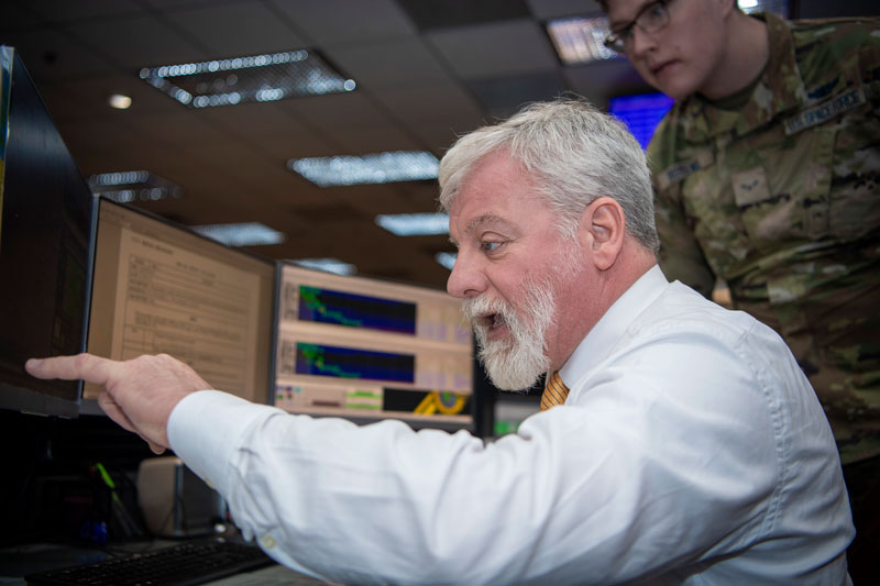
On the operations floor of the GPS Master Control Station at Schriever Space Force Base in Colorado, Luccio looks at feeds from a worldwide network of monitor stations and ground antennas. (Image: U.S. Space Force photo by Dennis Rogers)
The young operators on duty at the GPS Master Control Station, at Schriever Space Force Base in Colorado, receive feeds from a worldwide network of monitor stations and ground antennas, monitor the GPS satellites, and send them commands as needed. This month’s cover story features excerpts of an interview with their commander, Lt. Col. Robert O. Wray, about the training and duties of his team members, the challenges they face, and what brought him to his current assignment.
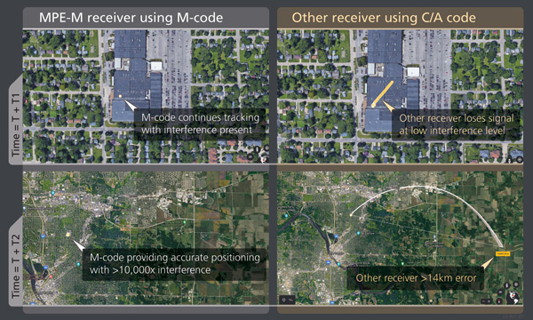
BAE Systems has produced more than one and a half million military GPS receivers. The company is transitioning receiver designs to use the modernized military code (M-code) signal for added resiliency in RF-challenged environments. We asked Luke Bishop, director and product line engineering lead for the company’s Navigation & Sensor Systems, a few questions.
BAE Systems’ MPE-M provides the benefit of M-Code operation in a challenged RF environment. Image: BAE Systems
Why transition to M-code?
There are three key reasons for users to transition to M-code as supported by Military GPS User Equipment (MGUE). First, MGUE provide U.S. forces and our allies with enhanced PNT capabilities while improving resistance to threats, such as accidental and intentional jamming. Compared to the current P(Y)-code signal specs, M-code signals are stronger. Second, MGUE provides improved resistance to spoofing. Third, MGUE is field programmable, enabling updates to accommodate future enhancements to the GPS enterprise, such as regional military protection (RMP).
Which user equipment is transitioning to M-code?
Successful MGUE Inc 1 prototype development is being leveraged into a full portfolio of weapons, ground and aviation/maritime M-code GPS receivers. Our first production M-code receiver, MPE-M, achieved production deliveries in CY2021, with more than 1,000 delivered. Additional M-code GPS form factors are under development.
We are also underway with the Foreign Military Sales (FMS) M-code program with MPE-M.
How is the transition to M-code proceeding?
As indicated by the January 2021 GAO report (GAO-21-145), M-code-capable user equipment is in the initial stages of Department of Defense (DOD) fielding for select weapon systems. Also noted by the GAO report, the DOD has conducted bulk purchases of the Increment 1 ASICs [application-specific integrated circuits] to ensure that “sufficient supplies of [them] are on hand for future integration into M-code card …based on estimated need through 2028.” We are at the beginning of M-code (MGUE). Time and the market will tell what ultimately happens.
Which of your receivers operate with an anti-jam (AJ) antenna?
BAE Systems’ receivers support both stand-alone AJ and integrated AJ. Receivers with integrated AJ include the NavFire-M, NavStorm-M and SABR-M receivers supporting high-dynamic weapons applications. Receivers directly supporting external AJ via a digital beamforming interface include the MPE-M and AMR. Our external AJ DIGAR offering provides exceptional performance for many stakeholders.
Do you use advanced signal simulation equipment?
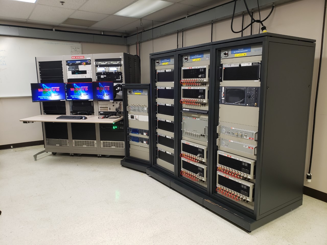
We integrate Spirent Federal and other signal simulators in both our test and development environments, where modeled RF signals are coordinated with other sensor measurements and host vehicle messages for high-fidelity hardware-in-the-loop test cases. Our engineers create hundreds of test cases and scripted test procedures to exercise our products under all required conditions. These simulations allow us to run thousands of trials to qualify and validate performance of our products in extreme scenarios.
BAE Systems’ hardware-in-the-loop simulation environments build upon Spirent Federal signal generators to test products under extreme dynamic and threat environments. (Photo: Spirent Federal)
Spirent Federal announced a new positioning, navigation and timing (PNT) test capability commonly referred to as programmable power — or flex power — available at no additional cost to qualified customers under support. The new capability allows the user to apply flex power configurations to existing scenarios.
Flex power is the reallocation of transmit power among individual signals in GPS satellites, providing a countermeasure against GPS jamming. Spirent simulators fully support programmable power for M-code, Y-code and C/A (coarse acquisition) code.
“From the time that we ascertained the need for flex power simulation, to the delivery of a completed easy-to-use utility, was a very short time,” said Ellen Hall, president and CEO of Spirent Federal. “It is this kind of responsiveness that we strive for here at Spirent Federal, so we can pass along the benefits to our customers.”
Flex power is available on the Spirent GSS9000 GPS / GNSS constellation simulator.
Simulator vendors explain their evolution in response to changes in GNSS/PNT, comment on technical challenges they face, and outline principal markets.
GNSS receivers — which were never as simple as FM radio receivers or garage door remote controls — are becoming increasingly complex. The causes for this include continuing efforts to:
reduce their size, weight, and power (SWAP)
utilize new signals from up to four GNSS constellations
integrate them with other sensors, such as inertial measurement units (IMUs), cameras, and lidars
take advantage of a growing number of public and private, global, regional, and local correction services
meet the requirements of booming new markets, such as autonomous vehicles
mitigate the threats posed by the proliferation of unintentional and intentional RF interference, the latter better known as jamming, and by spoofing.
In short, receiver manufacturers must constantly adapt to a GNSS/PNT landscape that is, as one of the respondents to this Q&A put it, “ever evolving.”
In turn, the growing complexity of GNSS receivers requires increasingly sophisticated simulators to test receivers and their integrations in controlled conditions before field testing and deployment. Increasingly, this is achieved by replacing with software what was once done in hardware. Simulation remains a vital, though often underappreciated, segment of our industry.
On the following pages, five simulator vendors briefly explain their evolution in response to changes in GNSS/PNT, comment on the principal technical challenges they face, and outline their principal markets.
Spirent Federal Systems’ GSS6450 RF record and playback GNSS simulator is portable, for testing automotive applications in the field. (Photo: Spirent Federal)
Lisa Perdue Product Line Director, Simulation Orolia
OROLIA
How has your approach to simulation changed over the years and in response to what changes in GNSS/PNT?
We have transitioned away from the GNSS simulator approach of using fixed, allocated hardware that we used in our early simulators to the more modern software-defined approach we use today. Given the ever-evolving PNT landscape, it is difficult to design hardware that will support all future GNSS and PNT simulation needs. Instead, we focus on the development of the Skydel software platform, which can then be used with the supported COTS hardware or turnkey system to generate the necessary signals. This gives us the benefit of maximum scalability and flexibility while being truly future proof.
The software-defined approach also allows us to offer Skydel in new and exciting ways. We aim to make PNT simulation accessible to everyone and we can do that through subscription and cloud-based simulation services.
What are currently the greatest technical challenges to GNSS/PNT simulation?
Today GNSS is only a part of the PNT picture. GNSS receivers are often tightly integrated with other sensors and many times the GNSS receiver cannot be isolated to test it on its own. Other sensors must also be stimulated or simulated and included as part of testing. Correction services are becoming more common, but many are proprietary with no public specification. With no common standards available, it can be technically challenging to create a one-size-fits-all test solution.
We tackle these challenges through our plug-in feature. The plug-in architecture allows you to expand the capabilities of Skydel by adding your own features or complex integration with other systems. It allows you to exchange information with the Skydel Engine and even integrates it into the Skydel UI. With our open-source SDK, which includes example plug-ins, you can create your data outputs synchronized to the GNSS simulation, such as IMU or correction services data.
In what markets and applications are your simulators used? Are they used only in labs or also in the field?
At Orolia, we say ‘Skydel Everywhere.’ Skydel is used in applications ranging from military encrypted receiver testing (SAASM, M-Code, PRS) to commercial applications supporting any of the GNSS signals available.
Skydel is used in systems that are found in labs, but you can also find Skydel at an individual engineer’s desk, or even home offices. In the field, Skydel has provided simulation and threat generation capability to authorized test ranges and field test events.
The broadsim software-defined GNSS is powered by Orolia’s Skydel GNSS simulator engine. (Photo: Orolia)
RACELOGIC
Julian Thomas Managing Director Racelogic
How has your approach to simulation changed over the years and in response to what changes in GNSS/PNT?
Over the years, GNSS technology has changed significantly but our approach of identifying a need and creating a solution hasn’t changed since we launched our first LabSat GNSS simulator. We created LabSat because we needed a cost-effective, accurate and easy to use record and replay simulator that we could use for product development and production line testing for our VBOX Automotive and VBOX Motorsport technologies. This need could not be met by any other simulator manufacturer, so we developed our own solution, which in turn became LabSat. Although our approach has not changed, the needs of users, including our own engineers, have, so we continue to develop and improve LabSat to meet these needs.
With the increasing number of satellite launches in market segments such as communication and navigation, the number of requests for testing space-qualified receivers has increased dramatically. To test these kinds of scenarios, we have been making some major upgrades to simulate rocket launches and Earth orbit trajectories that require very different characteristics from land-based simulation.
As the number of constellations and signals has expanded very rapidly, the number of simultaneous signals that need to be simulated has put a far greater requirement on the computing power needed to render them. We have been working very hard on optimizing our routines to make the most of the new breed of high-performance multi-core processors. The result has been a big decrease in the time taken to create a scenario, and an increase in the number of signals that can be simulated in real-time.
What are currently the greatest technical challenges to GNSS/PNT simulation?
The biggest challenge is in simulating a large number of constellations and signals in real-time without using dedicated, expensive hardware to create them. The good news is that with the latest Intel Xeon processors boasting up to 40 cores and 80 threads, a much larger number of signals can now be created in real-time using off-the-shelf PC components.
In what markets and applications are your simulators used? Are they used only in labs or also in the field?
With the global pandemic causing national lockdowns, many engineers switched to working from home. Our largest growth in the simulator market has therefore been due to providing these engineers with a small, low cost, easy to use simulator that they can have on their desks at home, allowing them to continue to develop GNSS applications without having to go into the office. The markets these engineers work within are as varied as the markets that use GNSS technology.
We have also seen a big increase in the use of our simulators to test mass produced satellites used in providing global internet coverage. These satellites are being produced in large volumes, and the need for a low cost, reliable testing method on the production line has driven strong growth in this area.
Our simulators are often used in the field to gather data for in-lab testing, as small size and battery life are very important factors in this environment.
SPIRENT FEDERAL SYSTEMS
Phillip Bonilla Senior Systems Engineer
How has your approach to simulation changed over the years and in response to what changes in GNSS/PNT?
Spirent has provided highly accurate simulation solutions since the early phases of GPS availability, starting with defined hardware for each signal type. As the GNSS landscape has grown, Spirent has worked closely with leading developers, adding key flexibility and functionality to adapt and provide a growing product portfolio. By adopting a robustly defined system architecture, and employing signal-agnostic hardware, Spirent simulators can generate any of the available constellations and frequencies, with no more than a few clicks of a mouse.
While broadening the support for the increasing number of constellations has been a focus, so too has the necessity to provide users with high numbers of available channels and auxiliary simulation needs. To complement GNSS simulation, significant effort is being devoted to resilient application testing, providing users with flexible solutions for introducing jamming and spoofing to the test environment. Our agnostic hardware supports signal generation using software defined radio (SDR), including interference sources and user-defined IQ signal data. As customer demands have grown, alternative RF and PNT sensors have been—and continue to be—incorporated, allowing users an expanded and comprehensive test environment.
The new spirent simulator generates alternative RF navigation signals concurrently with GNSS signals. (Photo: Spirent Federal)
What are currently the greatest technical challenges to GNSS/PNT simulation?
Today, nearly all industries rely on GNSS or other PNT sources to some extent. With such varied and widespread use, laboratory testing is critical, and maintaining the highest levels of accuracy, reliability and robustness remains one of the greatest challenges. For modern hardware-in-the-loop configurations, simulation systems must be able to keep latency consistent to enable powerful post-processing of results. With this challenge in mind, we at Spirent design and manufacture our own hardware, ensuring precision and ultra-low latency.
Another significant test challenge posed by modern applications is the growth in vehicle speed and maneuverability. Creating a truly realistic test environment for supersonic and even hypersonic vehicles with high rates of spin and jerk places huge demands on a simulator. Spirent recently has introduced the industry’s first 2 kHz update rate, enabling the most accurate trajectories for the most mobile technologies.
Lastly, positioning engines are becoming more complex. In addition to GNSS and inertial, vision systems and a range of other sensors and signals-of-opportunity are providing developers greater opportunity for precision and robustness. Therefore, a core part of Spirent’s mission statement is delivering test equipment that is designed to be integrated into wider test benches and ensuring that equipment is always orders of magnitude more accurate than any device under test.
In what markets and applications are your simulators used? Are they used only in labs or also in the field?
Spirent simulators are used in all phases of the product life cycle across nearly all applications. Receiver manufacturers use our solutions beginning with initial research and development, throughout product development, and well into production and field testing. Along with the ability to use Spirent’s simulators for live range testing, Spirent’s GSS6450 record and playback system enables users to record the real world in high dynamic detail for repeatable lab testing.
JACKSON LABS
Gregor Said Jackson President and CTO
How has your approach to simulation changed over the years and in response to what changes in GNSS/PNT?
Initially, we saw a large demand for GPS-only solutions. We are shipping units into this market and it is growing more than 30% year over year for us. Recently, customers are looking to also supporting other constellations. There is an emerging market for LEO simulation capability. Many LEO constellations are becoming reality, such as OneWeb, Kuiper, Starlink, Iridium, Xona, and others, and customers are more frequently asking if we can support these types of signals in our simulators. Demand also is arising for additional base-band signals to accommodate the RF signals, such as synchronized raw IMU data and other observables. Jamming and spoofing signals also are being requested and reproducing these as faithfully as possible is a big challenge for synthesized simulation. Lastly, we see demand rising for mil-type secure applications, such as M-Code, PRS (Galileo) and P(Y) code SAASM of course. The complexity of future simulators will rise in lockstep with the complexity of the RF spectrum coming to us from space.
What are currently the greatest technical challenges to GNSS/PNT simulation?
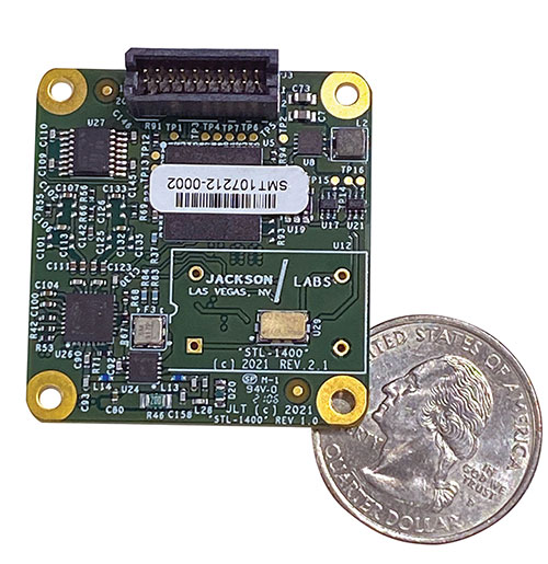
The STL-1400 positioning and timing receiver is designed for battery-operated low SWaP-C applications. (Photo: Jackson Labs)
A faithful reproduction of the real live-sky RF signals would rank high on this list. There are almost an unlimited number of out-of-band and in-band benign and adversary RF signals on a typical GNSS antenna these days, and more recently the sun has been acting up with solar flare activity that can disrupt GNSS signals. As GNSS receivers mature and become capable of tracking four, five or more carrier frequencies and constellations at once it becomes increasingly challenging to supply these types of signals from a simulator, and at a reasonable price-point. Sometimes, a wideband recording and playback system can do a better job at reproducing live-sky signals, however these systems are limited to playing back the same exact mission over and over again of course, and thus are not very flexible.
In what markets and applications are your simulators used? Are they used only in labs or also in the field?
Our simulators are built for two different applications: the first is a traditional type of GPS signal simulation where a Windows application allows a user to set up static or dynamic scenarios, allows them to upload NMEA playback files, create jamming or spoofing signals, and generally tweak the RF signal in many ways, such as modifying power levels and antenna patterns and even creating space vehicle failures in real time. Our customers range from car, aircraft, and avionics manufacturers, to R&D labs, to the government and academia.
Our simulators also are used for a hardware-in-the-loop application that we call transcoding. It allows glueless retrofitting of existing GPS equipment with any and all the emerging PNT solutions such as LEO positioning and timing, celestial navigation, INS/IMU, CSAC holdover, and concurrent/multi-frequency GNSS using a 1×1-in. transcoder module. Our transcoders fly on Air Force aircraft, are used to retrofit telecom equipment, and allow deep-indoors and underground GPS reception. Transcoders created an entirely new market for simulators.
SYNTONY GNSS
Sylvain Daubas GNSS Simulators R&D Teams
How has your approach to simulation changed over the years and in response to what changes in GNSS/PNT?
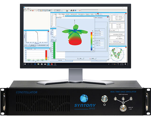
Manufacturers of GNSS receivers are targeting more precision and availability, especially in urban areas, which require acquiring more signals from more constellations and greater effort to minimize multipath errors. This confirms that an SDR design for signal generation is decisive to keep systems cost-efficient, as it directly benefits from Moore’s law. For instance, our new RTGS4-12 configuration is about four times more powerful (240 channels) than our previous standard configuration, for a similar budget level.
Regarding precision and RF quality, our simulators benefit from the same RF cards as Echo, our high-fidelity record and playback equipment, with a state-of-the-art RF front end: three channels at a 100 MHz sampling rate and a 16 bit IQ. The capacity to simulate protected signals is also crucial: with PRN Link, Constellator is ready for any present or future signal with encrypted spreading codes.
What are currently the greatest technical challenges to GNSS/PNT simulation?
Building a CRPA simulator is not an easy task, as this requires extreme levels of phase and time synchronization between several RF outputs, typically four, seven or more. This can be done in two ways: with a dedicated new RF board running with a single synthesizer for all channels or using the classical one, to which one should add a complex calibration mechanism. SYNTONY has made the tough choice, investing more at first in a mono-synthesizer version. However, this will benefit our customers, for which the usage will be simplified and it will save them a lot of time by shortening the calibration phase. This version already is available for sale.
On another note, it is a significant challenge to keep our product and its interfaces user friendly while also enabling our clients to configure each of the more than 500 parameters available (at the last count). We also keep in mind that new signals may appear, from LEO constellations for instance, answering to new needs such as autonomous driving. Constellator is HW ready for them, only requiring a software update.
In what markets and applications are your simulators used? Are they used only in labs or also in the field?
Constellator currently is mainly used in laboratories, in many market segments. Because it was initially built in partnership with spacecraft manufacturers, it benefits from the high standards of performance of space industries and includes several advanced space-dedicated features.
On top of the typical usage inside the labs, two other SYNTONY simulator products that are directly derived from Constellator are used in the field:
ECHO Recorder & Playback is used to record the GNSS environment with ultra-high fidelity: today @ 100Mhz, and before the end of 2021 even up to @ 200Mhz. ECHO has been used by our customers in cars, trains and often in aircraft test flights. Another usage of ECHO is to detect and record scintillation phenomena, as we will soon do in Brazil.
SubWAVE (GNSS coverage extension for underground places) allows indoor positioning with precision, directly compatible with standard GPS receivers, which can be crucial for safety or operational reasons. We have installed SubWAVE inside subways stations and tunnels (for example, in Stockholm, Paris and New York), in road tunnels (soon in France, in the “Tunnel du Mont Blanc”), in an underground bus terminal (also in Stockholm), in underground train stations (in Switzerland), and before the end of 2021 also in an underground mine (in Finland).
Spirent Federal Systems, a provider of PNT/GNSS test equipment, announced plans to fully validate the inertial interface between Spirent GNSS simulators and both Northrop Grumman legacy and modernized inertial systems under the EGI‐M program.
For years, Spirent Federal has developed inertial interface test tools in collaboration with Northrop Grumman that yield repeatable, accurate results.
Northrop Grumman’s embedded GPS/inertial navigation system (INS)‐modernization, or EGI‐M, program is developing airborne navigation capabilities with a government‐owned open architecture. The fully modernized system integrates new M‐code capable GPS receivers, provides interoperability with civil controlled air space, and implements a new resilient time capability.
“Spirent Federal has long supported testing of the Northrop Grumman family of interfaces,” said Jeff Martin, Vice President of Sales for Spirent Federal, “and our customers have always obtained precise, reliable results. Spirent Federal strives to keep abreast of the newest technology to be ready to meet the needs of industry, and this collaborative effort that includes the EGI‐M program is yet another example. Spirent is an important part of Northrop Grumman’s test solutions and this validation project acknowledges that importance.”
Spirent Federal has been providing tools for testing inertial systems for more than two decades. Available SimINERTIAL interfaces comprise various EGIs and IMUs from manufacturers of inertial sensors, including Northrop Grumman (formerly Litton), Honeywell and Atlantic Inertial Systems, as well as standardized interfaces such as STANAG.
Testing the full operational performance of GPS/inertial systems usually requires expensive and time‐consuming field testing on a moving vehicle. Spirent’s SimINERTIAL system emulates inertial sensor outputs while concurrently simulating GPS RF signals, enabling controlled, repeatable testing of EGIs and reducing the need for field trials.
Among the enhancements, a doubling of the update rate means the GSS9000 series now offers the ability to recreate operations more precisely and realistically, reducing uncertainty in positioning, navigation and timing (PNT) testing.
The latest developments provide the GSS9000 series with the ability to run simulations at a software and hardware update rate of up to 2 kHz, improving accuracy of the simulated trajectory without compromising performance. This is of particular benefit to high-dynamics applications, such as space missions and hypersonic vehicles. The increased update rate also delivers lower latency for hardware-in-the-loop (HIL) testing, further reinforcing the GSS9000’s position as the industry’s most accurate and realistic test instrument.
“Our dedicated hardware and powerful software solutions are built specifically with PNT test in mind — to improve accuracy, increase flexibility and provide high-performing systems to meet customer needs,” said Adam Price, Spirent director of PNT simulation. “These latest enhancements to the GSS9000 continue to raise the bar for highly flexible and scalable solutions that enable our customers to stay ahead of their competition.”
Other enhancements to the GSS9000 Series include:
Extended Scenario Duration. In a simulation environment, where control and repeatability are key for a realistic representation of the mission, reducing the number of user inputs is essential. The new update will extend the available scenario duration to 65 days, using the same initial conditions for the simulation throughout the duration of testing to deliver uninterrupted high-performance simulation for longer.
Enhanced Embedded Interference Capabilities. To provide greater power and flexibility in interference testing, Spirent has improved support for interference testing on wide spectrum signals, increased bandwidth resolution and repetition rates, and added variable bandwidth control on additive white Gaussian noise (AWGN).
“Spirent’s leadership in GNSS testing comes from the combination of our unrivalled heritage and deep understanding of the PNT market, alongside our continuing commitment to improving test capabilities for customers,” said Ricardo Verdeguer Moreno, product line manager for high-end applications. “By working closely with customers, we are able to better understand the challenges they face, and these latest enhancements to the GSS9000 series demonstrate how we are continuing to help customers reduce uncertainty by providing more accurate operations, without impacting system performance.”
The enhancements to the Spirent GSS9000 series will be available to new and existing customers at the beginning of the second quarter of this year. For more information, visit the GSS9000 Series product page. U.S. government and prime contractors should contact Spirent Federal for details.