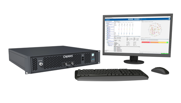
Spirent Communications, now part of Keysight Technologies, has launched SimXTRACT, a GNSS test tool that bridges the gap between field and laboratory.
SimXTRACT enables signals captured in field environments to be comprehensively decomposed into individual, discrete signals and applied to lab simulation for realism at every stage of the development test cycle.
“By combining real-world insights with lab-based control and repeatability, our customers will no longer have to compromise on how they test in this fast-moving technology area,” said Peter Terry-Brown, divisional CEO of Spirent’s Positioning business. “SimXTRACT ensures customers get the best of both worlds, with enhanced realism delivering more accurate results, quicker issue resolution, and faster time to market.”
Developers usually rely on either RF record-and-playback or lab simulation for testing and validation of PNT systems and devices. While both methods play important roles in product development, neither is able to combine the richness of the real world with the control needed for tasks such as research and development, receiver integration, or regression testing.
The introduction of SimXTRACT brings the advantages of both field and lab test methods together by taking real signals captured in field environments and accurately breaking them apart to create realistic simulator drive data for use in Spirent simulators.
Using signals and scenarios captured in the field by Spirent record-and-playback devices, SimXTRACT performs complex signal decomposition, breaking down each received signal into discrete line-of-sight and multipath ray paths, along with metadata such as Doppler offset, code error, power level, and angle of arrival (AoA).
This decomposed environment is then automatically converted into fully controllable simulation scenarios for Spirent GNSS simulators, reducing time spent in the field, cutting the cost and complexity of scenario capture and generation, and enabling repeatable, high-fidelity testing.
Combined with the option for developers to analyze and understand signal recordings, as well as search for and recreate specific conditions in order to focus testing, SimXTRACT will help accelerate development workflows for sectors that include automotive, chipset, consumer devices, defense, critical infrastructure and more.
“In today’s high-precision PNT ecosystem, SimXTRACT redefines how you can develop, test and debug PNT-enabled systems,” said Terry-Brown. “You can now bring the real-world environment into every stage of your product realization process, saving you time and money, while also improving product quality.”
Project establishes innovative test framework to help UK operators, providers and suppliers adopt best practice and benchmark success
Spirent Communications, now part of Keysight Technologies, has partnered with the European Space Agency (ESA) to lead an initiative aimed at increasing the resilience of positioning, navigation and timing (PNT) systems used in critical national infrastructure. Under the initiative, Spirent and partners will deliver a comprehensive test framework to drive measurable resilience in PNT systems for users, operators and providers of critical infrastructure in the United Kingdom.
Supported by Element 2 of ESA’s Navigation Innovation and Support Program (NAVISP), the initiative is designed to raise awareness and improve resilient PNT test and assessment by providing a pathway to assess, validate and rate PNT equipment and services used in critical national infrastructure. The 2023 UK government report The Economic Impact on the UK of a Disruption to GNSS estimates a seven-day GNSS outage could cost the UK economy £7.6 billion. Critical infrastructure is heavily dependent on satellite-based PNT systems and data.
“For years, organizations have been wrestling with a fundamental challenge: they know PNT resilience matters, but they do not have a clear way to measure it or benchmark their progress,” explained Mark Holbrow, vice president of Engineering and Product Development at Spirent Positioning. “This new initiative changes that by building the tools and frameworks that let critical national infrastructure operators quantify resilience, track it, and improve it over time, and we’re proud that ESA has entrusted Spirent to lead this exciting three-year project.”
The Resiliency in Critical National Infrastructure will support the UK government’s resilient PNT strategy by enabling access to rigorous, quantitative test evidence and operational insights that help evaluate and validate PNT systems across essential sectors. It will comprise three core components:
Spirent PNT Alliance brings together companies, academic research partners, and PNT professional and government bodies to identify, develop and cater resilience services for critical infrastructure. It will include the Royal Institute of Navigation and other strategic partners to complement their activities and help build a resilient PNT ecosystem in the UK by commercializing best practices and connecting infrastructure operators with new technologies and test approaches.
PNT Shopfront showcases solutions that aid the adoption of resilient PNT and help to assure regulatory compliance for critical PNT dependencies.
PNT Resiliency Health Check will enable independent appraisal of GNSS equipment capability against general performance, resilience and security criteria. Annual health check assessments will help organizations understand their dependencies, identify vulnerabilities, and track improvements over time, with a technical framework that scores resilience against standard benchmarks to create a pathway toward industry-wide test methodologies.
“Intentional and malicious disruptions to GNSS are now a daily occurrence, and are pervasive in the aviation and maritime sector,” said Ramsey Faragher, director of the institute. “The Royal Institute of Navigation is focused on raising awareness to these issues and in promoting the needs for improved resilience against such disruptions, especially within Critical National Infrastructure. Our Best Practice Guidelines emphasize the criticality of thorough testing in order to verify resilience and to help protect against both existing and future attack vectors. The UK is well placed to take a lead in this area, and well placed to inspire other nations to follow suit. We are really pleased to see initiatives like these from our corporate partners, and we look forward to supporting them.”
Spirent Communications, now part of Keysight Technologies, announced PNT Xe, a GNSS simulation platform designed to expand high-performance GNSS testing across the development lifecycle. The platform aims to reduce barriers to positioning, navigation and timing testing by offering simulation capabilities in what the company describes as an economical, multipurpose platform.
The company said PNT Xe addresses challenges manufacturers face in validating GNSS performance during accelerated development schedules. The platform’s hardware supports testing from early prototypes through production line verification for commercial and military applications.
“Until now, many organizations have been forced to use unreliable, inconsistent simulators or utilize ‘live sky’ signals as a way of conducting production testing,” said Peter Terry-Brown, divisional CEO of Spirent’s positioning business. He said PNT Xe makes the company’s simulation technology available for workstations, engineers and project phases.
Terry-Brown said the platform allows developers, integrators, design verification teams and production line testers to use consistent test methodology without compromising results validity. Many leading GNSS chipsets and modules are developed using Spirent’s simulators, he said.
The compact PNT Xe can be rack or desk mounted and features an interface designed to accelerate scenario creation. The platform can operate in lab or field environments and withstand variations in temperature and vibration while maintaining performance, according to the company. It supports all GNSS constellations and frequencies and includes AES M-Code access and a removable system disk for secure testing environments.
Rob VanBrunt, CEO of Spirent Federal Systems, called PNT Xe “a game-changer for defense customers.” He said the platform’s ease of use will help deploy new PNT technology faster, allowing software engineers to test code changes at their desks. Authorized GPS M-Code users can conduct unclassified military signal testing using AES M-Code without relying solely on secure labs, he said.
Marie Hattar, chief marketing officer at Keysight Technologies, said accurate, high-performance simulation becomes critical as positioning and timing technologies become foundational to 6G, defense systems and autonomous vehicles. PNT Xe makes that capability available to more innovators to validate performance, reliability and resilience at every development stage, she said.
Built on Spirent’s 40 years of expertise, PNT Xe is designed for development and production environments including low-altitude drones, vehicles, space applications, automotive, defense, and consumer devices.
The Japan Aerospace Exploration Agency (JAXA) has selected Spirent Communications to supply its lunar positioning, navigation and timing (PNT) simulation solution. The solution will support JAXA’s lunar exploration efforts and aid in developing essential navigation infrastructure for future moon missions.
Spirent’s PNT X solution allows JAXA to simulate lunar PNT services in a controlled laboratory setting before their deployment on the moon. This capability is critical for testing and validating navigation equipment for lunar missions in accordance with the emerging LunaNet specifications, which include adaptable S-band frequency solutions. The system also ensures scalability for future space exploration.
Using the PNT X system, JAXA can experiment with novel S-band signals and evaluate the performance of receivers that rely on standalone S-band Lunar PNT signals or a combination of Lunar PNT and Earth-based L-band GNSS infrastructure. The simulation of these signal combinations demands high levels of precision, which Spirent’s specialized architecture is designed to meet.
This collaboration builds on a longstanding relationship between Spirent and JAXA. In 2011, JAXA utilized Spirent’s simulation technology to verify the performance of early Quasi-Zenith Satellite System (QZSS) receivers. Since then, Spirent simulators have supported multiple advancements in QZSS.
Spirent’s lunar PNT simulation solution seeks to present new opportunities for space agencies developing lunar constellations, satellite and receiver developers and organizations planning lunar missions or seeking to establish additional PNT infrastructure on the moon.
The Spirent PNT X. (Photo: Spirent Federal Systems)
Developers and manufacturers of GNSS receivers have always needed to simulate the signals from GNSS satellites to test receivers in their labs and in the field. Now, as the vital role of GNSS for critical infrastructure and the growing threat of radiofrequency attacks are increasingly recognized, simulators must keep up. In particular, they must enable users to test a variety of new positioning, navigation and timing (PNT)signals from satellites in low-Earth orbit (LEO) and geostationary orbit (GEO), as well as realistically simulate sophisticated jamming and spoofing attacks.
In this cover story on simulators, we discuss these challenges with experts at four simulator manufacturers:
John Clark, Vice President, Engineering, CAST Navigation
Lisa Perdue, Product Line Director, Safran Federal Systems
Jan Ackermann, Director Product Line Management, Spirent Communications, and Paul Crampton, Senior Solutions Architect, Spirent Federal Systems
Avag Tsaturyan, Systems Engineer, M3 Systems.
How are the missions/applications of simulators changing?
Clark: Our customers have been requesting larger simulation systems that can support GNSS and inertial navigation systems (INS) on multiple vehicles simultaneously. Each vehicle is required to support a phased-array (CRPA) antenna sub-system, multiple INS interfaces and signal interference capabilities. This is a change from earlier times when our customers required smaller systems with less capability.
Perdue: We see a growing focus on testing NAVWAR scenarios and assessing receiver performance against diverse threats. The increasing complexity of receivers with multiple constellations and frequencies demands more advanced simulation capabilities. We provide comprehensive PNT simulators that support hybrid scenarios, in which simulated signals and threats are combined with live signals and sensors, creating a dynamic and realistic testing environment.
Crampton:For many years, simulators have been used to prove the capability of receivers and the systems into which the receivers are integrated. Testing ensures that receivers can perform as expected, including performance in boundary cases, which are tricky to recreate in live-sky conditions.
Over time, threats to navigation and timing performance began to dominate the schedules of test labs. Ensuring reliable performance in suboptimal operating environments is critical to receiver users. The workload of test labs has increased to the point where test automation has become necessary, not only in terms of increased efficiency but also just to keep pace with rapidly evolving threat profiles.
So, one of the main changes we are seeing is the need to speed up the innovation cycle with simplified, automated testing while maintaining test fidelity and robustness. Spirent simulators are enabling testing to “shift left,” to start testing earlier in the development cycle with digital twins — software-only models of receivers and devices — to shorten the time spent on R&D.
Ackermann: Increasing efficiency, flexibility and realism have been critical drivers in the simulator industry for many years and will continue to drive us forward at an ever-increasing pace. Precision and robustness requirements demand more signals and sensor fusion, which need to be supported by simulators. Greater realism and flexibility means that more representative testing can be done in the lab, saving time and money.
On the other hand, while lab testing has grown ever more realistic, there are times where in-field verification is required — simulators have had to become more flexible to address this “augmented reality” test environment and optimize field testing. Simulators are being used on ranges to enhance testing, using combinations of real and simulated signals — including resiliency tests that incorporate live-sky signals.
Are new markets for simulators emerging?
Clark: Yes, as the world evolves and circumstances change, the ability to validate proper operations of GNSS and GNSS/INS navigation systems under less-than-optimal conditions has become challenging. The use of simulators can greatly enhance your understanding of the behavior of a navigation system, thus allowing for more reliable navigation error planning and mitigation when these errors do occur. This has become a much more important area of concern as the automated navigation and integrated navigation markets mature.
Perdue: Yes, new markets are emerging in areas such as autonomous vehicles, UAV swarms, urban air mobility and space exploration, including lunar missions. Additionally, the growing focus on cybersecurity and electronic warfare has increased the demand for simulators that can replicate complex cyberattack scenarios and electronic threats.
Ackermann: New markets for simulators are constantly emerging. As PNT impacts more and more areas of our lives, the geographic and technological spread of simulator requirements continues to expand. Even in existing segments we see new market needs. In automotive, for instance, the emergence of a wide range of safety-critical functions such as intelligent speed assist (ISA) and eCall drive new simulation needs.
From the emergence of the LEO market to the development of LEO PNT constellations, these markets appear and evolve at a rapid pace. Spirent simulators can be used to generate novel and established signals from LEO PNT constellations with ultra-realistic orbital models for complex rotational effects and satellite parameters. The emerging focus on lunar missions from space agencies around the world means new test environments, more stringent requirements, and the potential for new signals outside of L-band, at S-band and beyond.
Crampton:Increasing the realism of testing continues to open new opportunities for simulator use. Spirent provides an all-in-one alternative PNT solution for ultra-realistic LEO modeling, inertial emulation, L and S-band signals, etc. — to be fused and tested in unison.
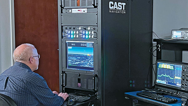
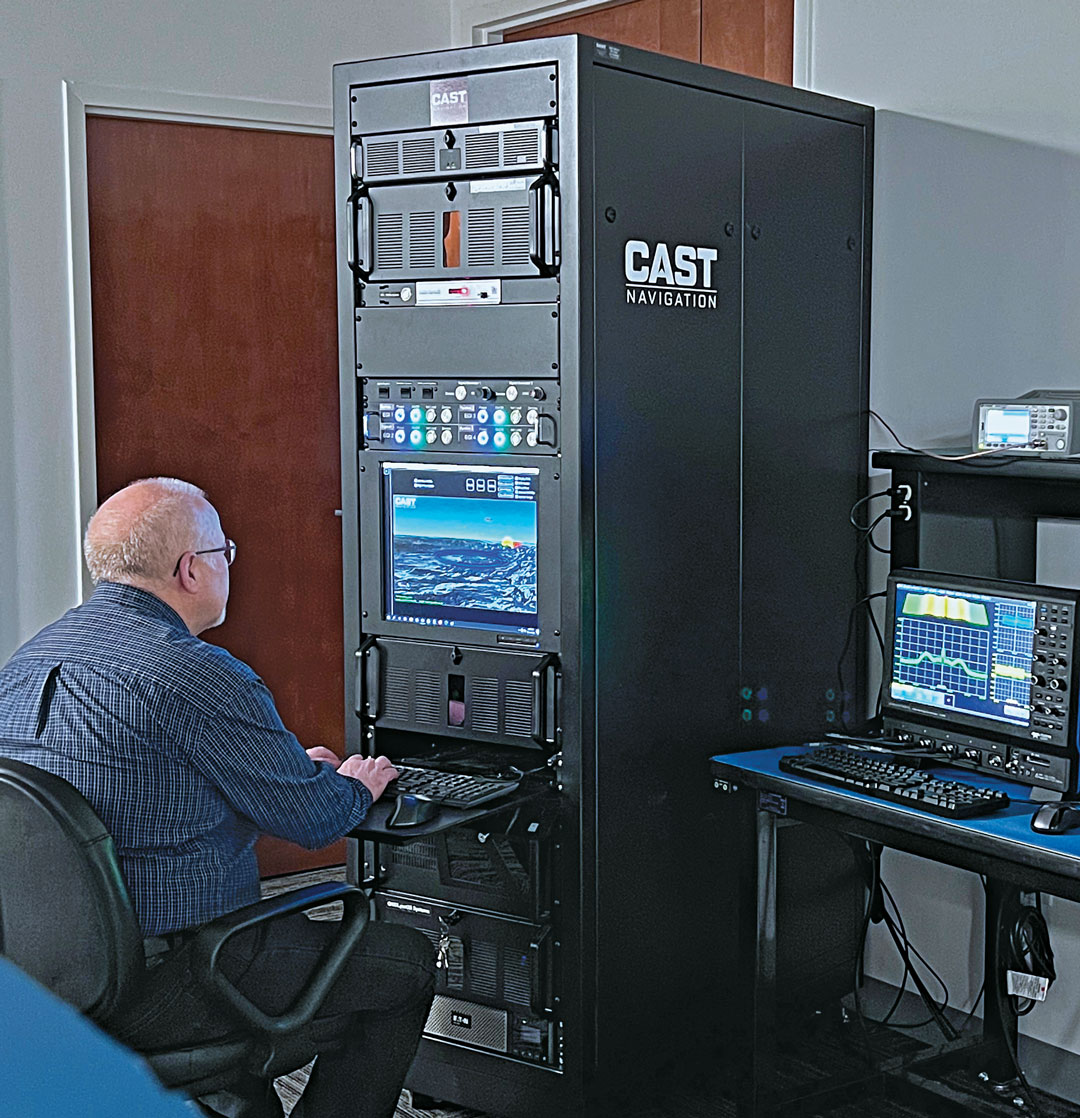
Senior Software Engineer Neil O’Brien utilizing a CAST-8000 GNSS Simulator to analyze CRPA trajectory data. (Photo: CAST Navigation)
Are simulator requirements changing?
Clark: In the past our customers were focused on the simulation of a single element of GNSS signals and a single INS output interface for the testing of vehicles that only supported single element antenna (FRPA) and a single INS capability. Our customers are now requiring simulator systems that produce multiple elements of phase-coherent GNSS signals that are commensurate with multiple INS interface outputs to drive navigation systems that can utilize a phased-array multiple-element antenna sub-system (CRPA) and multiple INS sources simultaneously.
Perdue: Yes, simulator requirements are always evolving. High signal counts are essential due to the increase in LEO constellations, and there’s a need to replicate multiple threats to create realistic environments. Built-in automation is crucial for managing these complex scenarios. The ability to add custom signals and constellations is necessary for experimenting with new technologies. Our software-defined architecture allows for quick integration of new signals, ensuring flexibility and responsiveness to changing needs. Innovations such as a radio utilizing the RFSoC to provide a high number of multi-frequency outputs from a single system and the BroadSim Duo, which offers dual-frequency capabilities in a compact form factor, demonstrate our approach to meeting these evolving requirements.
Ackermann: As new markets and use cases emerge, the simulator requirements evolve. The growing prevalence of NAVWAR threats, such as GNSS jamming and spoofing, and the range of systems these attacks are impacting is enhancing the criticality of lab testing.
Whether seeking to gain battlefield advantage or to secure civil operations (aviation, for instance), the ability to generate a wide range of NAVWAR attack vectors in complex scenarios is needed like never before. New waveforms must be incorporated quickly and realistically, while defensive technologies such as CRPAs must be exercised with a higher level of precision.
Crampton: Due to the demand for flexible attack vectors and the expanding range of available signals, simulators need to be capable of generating authentic RF environments from novel, user-defined waveforms. A time-saving method has been developed using prerecorded I/Q files. Spirent’s sixth-generation solution, PNT X, accepts raw I/Q data, analyzes the environment and the dynamic movement between receiver and transmitters, and automatically applies the correct motion effects to the generated RF signal. The simulated signal now has real-world dynamics without the need for manual inputs from the user. Realism made simple! Additionally, multiple I/Q-defined transmitters can be seamlessly integrated with native 3D terrain-modeling capabilities to create rich RF environments with multipath and obscuration.
A continuous, dynamic range is required to better replicate high-power jamming threats for controlled reception pattern antenna (CRPA) testing. With PNT X, high-power jammers can be simulated from the moment they become part of the noise floor to when a vehicle, such as an aircraft using a CRPA, passes by it. This continuous range enables CRPA developers to characterize null-steering ability with greater precision than previously possible.
Ackermann: As previously mentioned, there is also a growing need for integration and automation. Systems need to work in concert, and testing needs to happen quickly and efficiently to stay ahead of markets and threats. To this end, the ability to automate and to control remotely, and the ability to integrate seamlessly with other simulation and control systems, are core requirements for modern labs. Spirent is simplifying and automating testing with support for multiple industry-standard frameworks.
In established markets, safety requirements on devices under test drive simulator needs. For instance, functional safety requirements for automotive applications demand the ability to simulate threats and events, while the fidelity requirement of the simulation is elevated to assure conformance.
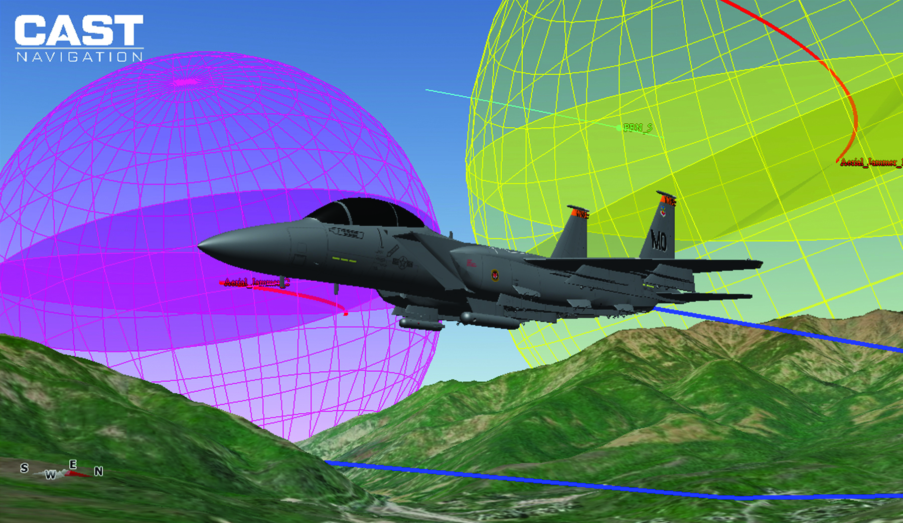
3D view of an aircraft flying a simulation. (Photo: CAST Navigation)
What mix of signals do you support?
Clark: GPS L1/L2/L5, L1C, L2C, C/A, SBAS, P, Y, SAASM, M-Code AES and MNSA, Glonass and BeiDou
Perdue: We support a wide array of signals, including GPS, GLONASS, Galileo, BeiDou, and regional systems such as QZSS and IRNSS. Additionally, we incorporate alternative navigation signals, such as those from Xona, and support inertial navigation and timing signals. Our software-defined architecture enables us to handle high signal counts and allows for extensive customization, ensuring we can simulate any required signal environment. This flexibility ensures we meet the diverse needs of various industries and applications, from aviation and maritime to autonomous vehicles and defense.
Ackermann:Spirent supports all open service GNSS signals and classified GPS testing — including M-Code Regional Military Protection — as well as PRS (through prs[ware] and our partnership with Fraunhofer IIS) on our simulation platforms.
In addition:
Regional systems (e.g., NavIC or QZSS)
S-band frequency signals
Custom non-ICD signals
LEO PNT (Xona Space System’s PULSAR and others)
A broad range of interference waveforms, including CW, FM, PM, wideband AWGN, chirp, matched spectrum, etc.
Generation of RF from I/Q data injection in L-band and S-band frequencies
Correction/augmentation
Inertial sensor emulation
Furthermore, the ability to geolocate custom RF beacons either in a range of orbits or in terrestrial locations adds huge signal flexibility.
What are the key challenges you face?
Clark: As our customers’ needs grow and evolve, some of our key challenges have been the ability to continue to evolve our product utilizing cutting-edge technology while still maintaining backwards compatibility with our older technologies. Efforts like this give our customers peace of mind when making a system purchase and enable them to take full advantage of prior purchases when requirements change and system enhancements are necessary.
Perdue: A key challenge is creating complex simulation environments that require specialized expertise. Customers often lack the knowledge to design these environments effectively. Ensuring simulation accuracy and cybersecurity are significant concerns, especially as new threats emerge alongside new technologies developed to combat existing threats. Translating performance requirements into practical specifications and meeting stringent industry standards adds another layer of complexity. We address these challenges through continuous updates and close collaboration with our customers to ensure our solutions meet their evolving needs.
Ackermann: For 40 years, we have faced a challenge that, to some degree, is being addressed. Namely, PNT is not widely standardized and therefore test requirements are highly diverse. The scale of Spirent and the empowering flexibility of our systems enables us to overcome this, but it remains challenging.
The current geopolitical situation also presents challenges, as the number of threats and the potential for negative events demand ever-increasing sophistication in testing. That’s why we built PNT X with high-power jamming and spoofing capability for greater realism and accurate test results.
Crampton: The complexity of next-gen positioning engines means that our systems have to integrate and interact with other systems, built by other companies with other protocols and specifications. Spirent maintains the precision and stability our customers expect from us while incorporating an open and controllable architecture for easier plug-and-play in complex hardware-in-the-loop environments.
M3 SYSTEMS
Please introduce your company.
Tsaturyan: We represent the Mistral Group, which includes three distinct companies: M3 Systems France, M3 Systems Belgium and Boreal. M3 Systems France teams provide GNSS simulation and test and measurements solutions and radionavigation and signal processing expertise. M3 Systems Belgium teams are experts in air traffic management (ATM) studies. Boreal teams offer beyond-line-of-sight missions for maritime surveillance, Earth observation, and scientific experiments with the BOREAL long-range unmanned aircraft. Each company extends its scope to the challenges of GNSS and UTM with an integrated approach.
What are your key markets? What challenges are you addressing?
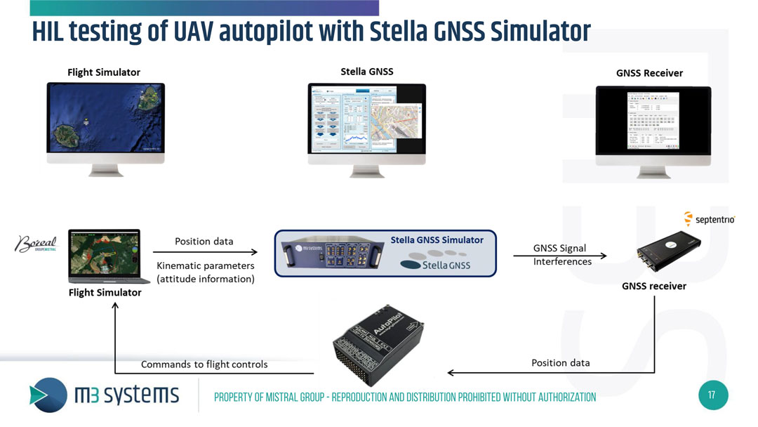
Our customers are from different industries: we work with space agencies — such as France’s Centre National d’Études Spatiales (CNES) and the European Space Agency (ESA) — private R&D labs and automotive companies and railways. We propose GNSS simulation products such as the Stella GNSS simulator, which allows users to simulate a vehicle in a realistic environment and in real time for low latency. Our simulator is designed to reproduce the sky with high precision. The GNSS signal passes through different layers, each one of which has a different effect. First, there can be an error in the satellite clock, then there can be a delay as the signal passes through the atmosphere, then, on the ground, there is a risk of a spoofing or jamming attack and, in urban areas, multipath from buildings.
What signals does your simulator support?
Our GNSS simulator is multiconstellation and multi-frequency. It supports all the available GNSS signals and frequencies. Users can simulate multiple antennas and multiple trajectories, custom atmosphere and multipath effects. We offer several built-in models of multipath. Users also can use their own multipath models and even integrate it with an SE-NAV multipath simulation tool. We also have several built-in jamming signals that users can apply and spoof the real signal coming from the antenna or spoof the simulated signal. Our setup now also supports Galileo’s Open Service Navigation Message Authentication (OSNMA). Our Stella GNSS simulation software can run on three different products designed for specific needs: the Stella GNSS Simulator Base (based on NI’s USRP kit), the Stella GNSS Simulator Suite (based on our bundle), and the Stella GNSS Simulator Advanced (based on NI’s VST). Our VST-based solution is optimized for tests that require high performance in terms of calibration — such as simulating a CRPA antenna, where the channels need to be very tightly synchronized.
Photo: M3 Systems
What does your Stella Suite do?
The Stella GNSS Simulator offers up to two independent RF simulations, enabling simultaneous simulation and the jamming/spoofing or the simulation of multiple antennas and trajectories.
Our simulator suite is basically an all-in-one device that allows users to plug in a receiver. This single device enablesusers to simulate jamming, spoofing, multiple antennas or multiple trajectories.
When did you launch this product?
We released it and demonstrated it during Emerson NI’s “NI Connect” event. They have an annual event in May in Austin, to which they invite all their partners and customers. This year, we were invited there to present our new simulator. We brought a HIL test setup to demonstrate the new configuration of our GNSS simulator: a closed-loop test of a drone autopilot system. When kinematic parameters from the flight simulator are simulated, the trajectory is sent to the Stella GNSS simulator, which then generates the GNSS RF signal and interference to assess the receiver’s performance. The receiver then passes its positioning data to the autopilot, which sends the commands to the flight control unit in the flight simulator. It’s one of the use cases, because to fully test the receiver, in addition to the nominal situation, it is also necessary to introduce some errors — such as interference, jamming, spoofing or meaconing.
What are some other use cases for this simulator?
Another use case is the test of Advanced Driver Assistance Systems (ADAS) in a 3D simulation environment. Basically, it is designed to test any unit that includes the GNSS positioning and to test the receiver’s robustness in case of jamming, spoofing, or meaconing.
Is this all done in the lab or can you put your box in a vehicle?
With this setup, it’s all done in the lab, but we also offer solutions to record the real signals from a UAV or a ground vehicle.
Are the challenges changing? Is the market changing?
Now, a GNSS simulator is no longer sufficient. Testing the receiver’s robustness against various types of attacks, particularly jamming, requires diverse methods. Consequently, there is an emerging need for simulating jamming mitigation antennas, such as Controlled Reception Pattern Antennas (CRPA).
A roundup of recent products in the GNSS and inertial positioning industry from the July 2024 issue of GPS World magazine.
MAPPING
Mobile Mapping System With integrated inertial labs INS/lidar
The Meridian mobile mapping system integrates the Mosaic X camera with Inertial Labs inertial navigation system (INS) and lidar to improve mapping accuracy.
The Meridian system offers panoramas with a 74 MP native resolution and 13.5 K resolution using precisely synchronized camera modules. The design minimizes image overlap to offer clearer and more consistent panoramas. The integrated INS system has a vertical accuracy of 2 cm to 3 cm and a precision of 2 cm to 4 cm.
It features seamless, out-of-the-box operations with fully integrated and calibrated components. The Meridian system is designed for ease of use and requires only minutes of training. In addition, it features a rugged design to ensure performance in challenging environments.
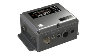
The Geo-APNT serves applications requiring precise navigation data and an accurate time reference. The Geo-APNT combines a versatile GPS master clock with an INS to
offer assured positioning, navigation and timing (PNT) under all circumstances, including temporary loss of GPS signal. It minimizes size, weight and power (SWaP) due to the integration of positioning and timing that are typically achieved by two independent subsystems.
It can be easily integrated into existing systems and supports RTK and PPK positioning and offers support for MEMS, fiber optic gyro and ring laser gyro inertial measurement units (IMUs). The system also includes GPS antenna and cables.
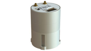
This line of tactical-grade IMUs is engineered to address the evolving needs of unmanned applications and 2 space-based operations.
The IMUs include Iconyx, a high-performance HRG-based IMU that significantly outperforms legacy technologies, the company says. It offers improved accuracy and reliability for demanding navigation needs. It also features a small tactical IMU (STIM) ideal for applications requiring lower size, weight and power (SWaP).
The company is upgrading its Geonyx inertial navigation system (INS), which is based on HRG technology, to incorporate M-Code capability. The fully integrated solution can perform in GPS- denied or spoofing environments, offering reliable navigation in challenging environments.
GPS-Aided INS For land, marine and aerial applications
The INS-FI, a GPS-INS, is designed for enhanced performance and reliability across various platforms including land, marine and aerial applications.
The INS-FI is built with tactical-grade fiber optic gyroscope (FOG) technology and an IP67 rating, indicating its robustness and resistance to electromagnetic and environmental interference. This system integrates an IMU that combines fiber optic gyroscopes and MEMS accelerometers, along with an all-constellations GNSS receiver supporting multiple bands.
It offers horizontal and vertical positioning with approximately 0.1% error of distance traveled for land applications and a drift of five nautical miles per hour for aerospace applications without GNSS signal. INS-FI is fully compatible with Inertial Labs’ Air Data Computer (ADC), visual inertial navigation systems (VINS) and a stand-alone magnetic compass (SAMC).
INS-FI incorporates sensor fusion filter technology, navigation and guidance algorithms and calibration software to ensure optimal performance and reliability. The system aims to provide precise horizontal and vertical positions, velocity, and absolute orientation (heading, pitch and roll) for any mounted device, maintaining high accuracy for both stationary and dynamic applications.
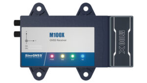
The M100X GNSS receiver is built with the Quantum-III SoC Chip, designed to provide full-constellation and multi-frequency capabilities, specifically engineered for high-accuracy vehicular positioning and heading.
The M100X features GNSS/INS integrated technology to provide real-time high- precision positioning, velocity and heading data, even in challenging environments.
The receiver provides accurate positioning and heading information across various applications, including autonomous mining trucks, intelligent ports, mapping and autonomous buses. It is designed to safeguard vehicles as they pass through areas with poor signal reception, even in obstructed environments such as urban canyons, city overpasses, underground garages, tunnels and parks.
The M100X has a data update rate of up to 100Hz, allowing it to perform well in
very dynamic environments, such as vehicles traveling at high speeds. This rapid update capability enables continuous and real-time tracking of vehicle positions for reliable computation and instant updating of navigation information. It also facilitates quick responses to changes in vehicle dynamics during travel. These features are essential for maintaining seamless operation in high- speed environments and ensuring high levels of safety and performance.
Constructed with aluminum alloy and rated IP67 for water and dust resistance, the receiver is built to withstand harsh operational environments. It also features a shock-resistant design, capable of surviving a drop from 1 m without damage. It can connect to 4G, LAN, Bluetooth and multiple I/O ports for seamless integration with various systems and networks.
The M100X can be used with the Navigation Master software, an Android app for quick device configuration and effective remote management. Using Bluetooth connectivity, users can configure their M100X devices for optimal performance. Additionally, its cloud platform, NaviCloud, offers instant access to projects and data from any location.
Spirent has implemented Xona Space Systems’ PULSAR production signals for seamless integration into the existing SimXona product line. The PULSAR X1 production signal implementation has passed Xona certification and the PULSAR X5 signal verification process is currently underway. It is expected to pass certification during the summer of 2024. Spirent is now accepting orders for SimXona with production signals capability.
Xona is developing PULSAR, a high-performance PNT service built on a backbone of low-Earth orbit (LEO) small satellites. Xona’s smallsat signals will improve PNT resilience and accuracy by augmenting GNSS while operating with an independent navigation and timing system architecture. Xona is fully funded to launch its production class satellite, the In-Orbit Validation mission, in 2025.
Spirent is the leading provider of PNT test solutions and recently launched a sixth-generation simulation system, PNT X. Designed for navigation warfare (NAVWAR) testing, PNT X is an all-in-one solution with native implementation of SimXona.
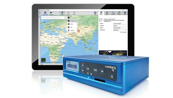
The LabSat 4 GNSS simulator is designed to meet the demands of modern GNSS signal testing. It is equipped with three radio frequency channels, each of which can be configured with up to 12-bit I&Q quantization and a bandwidth of up to 60 MHz. This allows users to precisely control recording parameters and optimize file sizes based on their specific testing requirements. Additionally, synchronized record and replay of external data sources such as CAN, CAN-FD, RS232 and digital event capture are designed to further enhance complex test scenarios.
Users can save custom record settings for efficient setup and repeatability. Additionally, a user-friendly, web-based interface allows for easy configuration and management of the simulation environment.
LabSat 4 offers file management capabilities with 7.6 TB internal storage and robust data transfer options via Gigabit Ethernet and USB 3.0. This technology accommodates the high- volume data needs of modern GNSS testing without sacrificing speed or performance.
It is small, portable and cost-effective, making it suitable for use both in the field and in the laboratory. LabSat 4 is fully compatible with SatGen Simulation Software, which allows users to create GNSS RF I&Q scenario files based on custom trajectories. This integration enables the simulation of scenarios involving multi-stop routes, time zone transitions, leap seconds and more, using any specified time, date and location.
BroadSim Duo is a dual-frequency GNSS simulator designed specifically for testing military receivers in an unclassified environment.
BriadSim Duo integrates dual-frequency capabilities within a single compact GPS military signal testing unit. The simulator has dual-frequency capability, which is essential for testing P-Code and AES-M-Code. It features a new software-defined radio in an M.2 form factor, offering robust and reliable performance. It also seamlessly integrates with the Skydel simulation environment for improved versatility and functionality.
Adtran has released two optical cesium atomic clocks, the OSA 3300 Super High-Performance (OSA 3300 SHP) and the OSA 3350 Super Enhanced Primary Reference Clock+ (OSA 3350 SePRC+). The devices use optical pumping technology to meet evolving demands across applications from scientific research to critical PNT infrastructure.
The OSA 3300 SHP offers stability and accuracy, making it a valuable tool for metrology institutes and scientific research facilities. The OSA 3350 SePRC+ is specifically designed to enhance holdover capabilities for PNT services.
It maintains 100 days of 100-nanosecond precision, providing continuous and accurate timing even in environments where GNSS is compromised or unavailable. This makes it a crucial
component for ensuring the integrity of mission-critical networks and supporting vital infrastructure and defense operations with reliable backup timing.
The Zenith60 Pro GNSS smart antenna is designed for surveyors and construction professionals. It is a real-time kinematics (RTK) rover that features calibrated free tilt compensation to measure otherwise inaccessible points. The antenna is suited for harsh climates, urban areas, dense canopy coverage or other challenging terrains.
This multi-constellation, multi-frequency GNSS receiver features a GNSS board with more than 800 channels and IP68 protection against dust and water. It also connects with GeoMax total stations and X-PAD field software to create an efficient and flexible workflow.
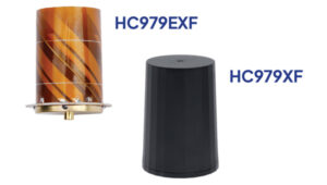
The HC979XF antenna is designed to provide optimal support for the entire GNSS band, including GPS/QZSS L1/L2/L5 (QZSS L6), GLONASS G1/G2/G3, Galileo E1/E5a/b/E6, BeiDou B1/B2a/b/B3, NavIC L5 and L-Band corrections services.
The key new feature of the HC979XF and HC979EXF antennas is the support for Galileo’s Global High Accuracy Service (HAS) and QZSS’s regional Centimeter Level Augmentation Service (CLAS). Both correction services are broadcast in the E6/L6 band (1258- 1300 MHz).
The radio frequency spectrum has become congested worldwide due to the activation of many new LTE bands. Their signals or harmonic frequencies can affect GNSS antennas and receivers.
In North America, the planned Ligado service, which will broadcast in the frequency range of 1526 to 1536 MHz, can affect GNSS antennas that receive space-based L-band correction service signals (1539 – 1559 MHz). New LTE signals in Europe [Band 32 (1452 – 1496 MHz)] and Japan [Bands 11 and 21 (1476 – 1511 MHz)] have also affected GNSS signals. Calian’s XF models are designed to mitigate the effects of these new signals.
The Calian HC979XF housed helical antenna weighs 42 g and is enclosed in a military-grade IP69K plastic enclosure. The embedded HC979EXF helical antenna weighs 8 g. It is easily mounted with an optional embedded helical mounting ring, which traps the outer edge of the antenna circuit board to the host circuit board or any flat surface. An MCX connector is installed in the base of the antenna.
WingtraCLOUD software is designed to simplify data collection and streamline the onboarding of surveyors and pilots.
WingtraCLOUD offers a user-friendly flight planning experience, plus time-saving features including site-based file organization, advanced 3D planning, coordinate system by sites and improved connectivity via cloud syncing in a single environment.
It aims to simplify and streamline site setup and team collaboration. WingtraCLOUD’s features accelerate planning and introduce anew level of transparency among stakeholders with enhanced wireless functionality. Users can now provide insights to regional and global site managers across projects.
WingtraCLOUD allows users to maximize Wingtra aerial data and services, offering UAV program scaling and business advantages across a variety of industries.
FLYC-300 is designed 2 for advanced applications in UAVs, unmanned ground vehicles (UGVs) and autonomous mobile robots. Weighing 297 g, the FLYC-300 features a low size,
weight and power (SWaP) form factor and delivers 100 TOPS AI performance. It supports autonomous navigation, object detection, real-time inference, and SLAM capabilities.
The FLYC-300 is suitable for industries such as inspection, logistics, rescue operations, security, agriculture and environmental monitoring. It supports a variety of sensors and cameras, accommodating RGB, infrared, hyperspectral, HDR and high-resolution cameras. It can seamlessly integrate with flight controllers, vehicles or robots.
The computer can operate with a wide voltage input range from 4S to 14S battery packs or 12 V to 60 V DC input via the XT30 DC-IN connector, making it versatile for different unmanned systems. It also supports 5G or 4G modules for real-time transmission of images, videos and data. The computer is available in two configurations, with or without an enclosure, to meet varying application needs.
The VTOL hangar drone combines the JOUAV JOS-C800 hangar with its new VTOL fixed-wing UAV, CW-15V.
This “drone-in-a-box” solution isdesigned to offer amore efficient and versatile solution for businesses looking to optimize their routine operations through automated aerial technology.
The JOS-C800 hangar system is composed of an automated hangar, a newly developed VTOL fixed-wing drone CW-15V, and the Jocloud management platform. This system enables complete management and monitoring of automated aerial missions through cloud-based remote operations.
Its key features include autonomous takeoff and landing, intelligent flight planning, automatic charging, data management, intelligent data analysis and report generation, enabling fully automated drone operations without the need for on-site personnel.
The JOS-C800 uses AI and AR algorithm integration to classify and identify potential hazards in the collected data, supporting the display and management of these hazards on Jocloud, and generating detailed hazard classification reports. The upgraded algorithms allow for real-time stitching and comparison of video data comparative analysis to identify new or changed hazards.
It supports multi-UAV, multi-hangar operations with staggered takeoffs, allowing for hop-and-fly operations. The CW-15V UAVs can be paired with various payloads such as gimbal cameras, lidar and oblique cameras.
INVOLI, a specialist in cooperative air traffic surveillance solutions, has partnered with MatrixSpace to create a comprehensive air traffic awareness solution through a unified platform.
The partnership combines INVOLI’s cooperative detection technology with MatrixSpace’s advanced non-cooperative detection capabilities, facilitated by miniaturized primary radar technology. This integration allows for complete surveillance of both airborne and ground-based traffic, significantly enhancing UAV detection, counter unmanned aircraft system (CUAS) capabilities and safety for beyond visual line of sight (BVLOS) operations.
The integrated solution is designed to be low in size, weight, power and cost (SWaP-C), and can be deployed quickly without the need for additional infrastructure or specialist training. This makes it suitable for a variety of applications, including surveillance of sensitive sites such as prisons and energy infrastructure, as well as supporting safe and efficient BVLOS UAV operations.
NavStorm-M is a gun-hardened integrated anti-jamming GPS receiver for artillery, bombs, missiles and unmanned systems.
It features a layered protection approach using beamforming, anti-spoofing, resiliency and software assurance. It is an assured positioning, navigation and timing (A-PNT) device featuring M-Code GPS technology. It offers GNSS protection of two bands (L1/E1+L2 or L1 + G1 or L1/E1 + L5) from up to three directions of jamming simultaneously.
NavStorm-M is designed to meet the tight size, weight, power and cost (SWaP-C) requirements of unmanned aircraft systems, loitering munitions, hypersonic platforms and other weapons — especially in gun-hardened applications. NavStorm-M offers precise GPS navigation as a stand-alone system or integrated with an INS.
GPSdome2 is a high-end anti-jamming and fully retrofit solution tailored for defending manned and unmanned ground vehicles and UAVs from jamming attacks. It can be integrated with various GNSS off-the-shelf receivers. Using up to four off-the-shelf active antennas, with dual-band protection — GPS L1+L2 or GPS L1+Glonass G1 — it protects from up to three jamming directions simultaneously in each band. With optional mil-spec compliance, it can serve smaller and lighter platforms.
Atlas is a Group II loitering munition with robust capabilities in air, land and sea tactical scenarios. With a flight duration of more than two hours and a striking distance comparable to larger Group III aircraft, Atlas delivers mission flexibility and performance.
Designed for high-impact scenarios, it supports a range of operations such as intelligence, surveillance, and reconnaissance (ISR)/detect, identify, locate and report (DILR), electronic warfare and direct-action engagements. The munition’s payload includes options for fragmentation or penetration effects, further enhanced by optional ISR capabilities.
Zoe M4 is a portable and foldable quadcopter platform designed to rapidly deploy an overwatch capability for military personnel and units. It is easy to transport and set up, making it ideal for security, ISR (intelligence, surveillance, and reconnaissance), and emergency response applications.
It is equipped with the NextVision Raptor X80, a military-grade EO/IR gimbal that offers stabilized daytime and night-time imagery with 80x zoom and thermal imaging in high resolution. The NDAA-compliant quadcopter features the same rugged capabilities as the base Acecore Zoe model, including a robust carbon fiber construction, an all-weather waterproof design and the ability to survive winds of up to 29 knots.
The Zoe M4 is paired with Acecore’s Signav Ultra ground control station (GCS), a lightweight handheld device based upon the Panasonic FZ-M1 tablet and rated to MIL-STD-810G. It can be factory-configured for compatibility with existing military networks or frequency bands between 1625 to 2510 MHz.
Spirent Communications recently introduced a new GNSS and PNT simulation system, the PNT X, which brings together L-band, S-band, and alternative navigation signals, as well as Regional Military Protection (RMP) support. I discussed the new product with Ricardo Verdeguer Moreno, lead product manager for the company’s positioning technologies business unit.
What is the PNT X and how does it enhance Spirent PNT test solutions?
PNT X is the sixth generation of our PNT simulation platforms. It builds on the software-defined architecture that we have on the GSS9000, addressing all the changes in the industry in the decade since we launched it. The core focuses for our development remained system performance, signal fidelity, solution scalability and configuration flexibility. There are also different features that further enhance the realism of our solutions. Additionally, with the future in mind, we have tried to enable testing using as many of the available signals of opportunity as possible, alongside GNSS and emulated inertial outputs.
What are the use cases that have driven these changes?
Some of the emerging use cases driving this need for change are demanding more signals and a wider variety of them. For instance, LEO-PNT in concert with GNSS — and particularly when you add in reflections for multipath — can demand a high density of independent signals.
In addition, many applications are beginning to look beyond L-band, not only for regional systems such as NavIC or KPS, but also for applications such as lunar PNT. That’s why we have made a seamless integration of S-band frequency upconverters into our system.
What are some other use cases?
First and possibly foremost is NAVWAR. Jamming and spoofing threats have been growing in prevalence and variety in recent years. With conflict and tensions around the world, and with the greater reliance on PNT from both defense and civil applications, the ability of developers to validate systems against threats in the lab needed to be enhanced. Several of the advances of PNT X have been designed to achieve this.
One of them, and one of the main changes in our offering, is that we are introducing 3D terrain modelling within the GUI. Previously, simulations using just the GSS9000 were 2D and did not enable users to bring realistic multipath and obscuration signatures into the test. With 3D terrain modelling, users can define the environment in which their vehicle or device is, or is moving through, and this environment will interact realistically with all signals present in the scenario. This can include GNSS, LEO PNT, novel ground-based and space-based PNT signals, jammers, spoofers and I/Q-defined transmitters.
If you imagine your receiver somewhere in a landscape or a city, and there are jamming beacons somewhere in your vicinity, these could impact the performance of your system. However, the performance of your system will also be impacted by the obscuration of GNSS signals, and of the jamming signals. So, it enables you to convert a pure or ideal GNSS simulation, in which you are considering all the signals that are around you, into a realistic one that only considers the ones that you would see in the real world. We want our users to be able to bring as much of their testing into the lab as possible, and this enhanced realism helps to achieve that.
Some of the testing we’ve done on this, in partnership with our customers, has yielded some very interesting results.
Tell me about your new solutions for I/Q-defined transmitters.
In the past few years, some customers have been dealing with special interference waveforms against which they want to harden their systems. They are starting to use I/Q data to generate those signals in our system without us getting directly involved. The problem is that the content you have in the I/Q file is what gets used to generate RF. Imagine that you have a receiver that is moving around the transmitter. The relative movement will cause some Doppler offsets, signal delays, and power level offsets. By using pre-recorded data, you lose all that information because you cannot consider the dynamics of the scenario.
Our solution to that problem is SimIQ spatial awareness. PNT X takes the I/Q, analyzes the scenario and the relative movement between both entities and then automatically applies the right effects to the signal. So, the RF that you get when you are testing your PNT system fully matches scenario dynamics.
Because of features like this, it would be fair to think of PNT X as a platform or a tool for developers and testers. When users want to break new ground — test against new threats or utilize new sources of PNT — they do not have to wait for us to implement those signals. They can define the raw waveform and PNT X will apply all our years of expertise to add realism to that waveform.
This has obvious applications in the NAVWAR domain, but it also helps to future-proof both the PNT X and our customers’ labs. As we start to look beyond GNSS for added robustness and resilience, and the continuity needed for autonomous platforms, PNT X users can iterate, evaluate, and make informed decisions far of the additional PNT sources coming into operation!
How does PNT X support testing for LEO PNT signals?
Thinking about alternative and complementary PNT, and even about new communications technologies in general, LEO is a key focus area. PNT X offers a toolset to enable both the creation of high-performance LEO constellations and the downstream testing of devices utilizing new LEO PNT signals.
We have built in highly realistic LEO orbits for modelling the constellation and for testing the devices using it. We’ve incorporated factors such as drag coefficients, mass, and cross-section area to deliver the most realistic solution available. For testing applications that can’t feasibly be field-tested, lesser solutions just aren’t viable. For instance, utilizing MEO models for LEO testing just bakes error into the test scenario before you even start.
In addition to modelling the orbits of the constellations, we are enabling the generation of novel LEO PNT signals. This includes the first and only Xona-certified ICD implementation for generating Xona Space Systems’ PULSAR signals, meaning chipset, receiver, and device developers can utilize the full LEO constellation, using the most precise representation of the real thing, years before it is at FOC.
We have also sought to enable the development of other PNT systems. PNT X enables the generation of novel PNT signals using two different methodologies. Users can either inject new signals via I/Q data files, or they can use our FLEX software feature to modify existing L-band and S-band signals. In this respect, as in many others, the PNT X represents a platform or a toolkit for developers. We’re offering the opportunity to use our established expertise and precision to push boundaries, and to do so in the most simple and user-friendly fashion. It’s a blend of realism and control that hasn’t existed before in PNT testing, and it can deliver key advantages to the user — in terms of time saved in the field, of being able to iterate and test rapidly and reliably, and of assessing and implementing new technologies ahead of the market.
There are several complementary PNT systems — not just in LEO but also ground-based. Which ones do you cover?
In addition to enhancing performance and realism, flexibility is a key goal for us. Take, for example, Locata. With the PNT X, if you have I/Q files of Locata signals, you could simply define ground transmitters in the scenario and assign the I/Q files to each of them. Then, we have the SimIQ spatial awareness feature, so that, no matter what the content of that I/Q is, even if it’s a “pure” waveform of Locata signals, you can start moving around and traveling with any sort of vehicle in our scenario and PNT X automatically applies the realism — all the different signal effects — that are happening because of that movement. It really simplifies testing. Furthermore, Locata signals are in the S-band, so we can natively generate them with our upconverters. Locata is simply a good example because it mixes all these features and capabilities. Because it’s a ground-based system as well, you can use terrain modeling to locate your transmitters and to understand how performance would be impacted by realistic multipath and obscuration effects.
GNSS — delivering up to millimeter accuracy from 20,200 km in space with a received signal of one tenth of one millionth of one billionth of a Watt — is, in Arthur C. Clarke’s famous definition, “indistinguishable from magic.” Yet, in addition to the inherent errors in the transmission, propagation, and reception of their signals, GNSS are increasingly challenged by jamming and spoofing attacks, especially in and near conflict zones.
For that reason, as any regular reader of this magazine knows, combating jamming and spoofing and building resilience in positioning, navigation, and timing (PNT) systems has been a constant theme of many of our articles and industry news items for years.
The U.S. National Space-Based Positioning, Navigation and Timing Advisory Board has been focusing on how to “protect, toughen and augment” GPS, with the third word referring both to enhancements to GPS and to the “provision and use of alternate sources of PNT that complement, back up, or replace (partly or entirely) use of GPS.”(*)
For this cover story, I discussed complementary sources of PNT with executives from four companies that design, produce, and/or operate them. They cover a wide range of complementary PNT technologies. Read the exclusive interviews below:
Iridium owns and operates a constellation of satellites in low-Earth orbit (LEO) and has global rights for L-band spectrum. This enables it to operate the Satellite Time and Location (STL) system developed by Satelles before it recently became part of Iridium. STL protects critical infrastructure by providing a timing signal that is independent of GNSS constellations and 1,000 times stronger than the GPS signal.
Spirent Communications’ latest simulation system brings together GNSS and a wide range of other PNT systems. It simulates L-band, S-band, alternative navigation signals, signals of opportunity and emulated inertial outputs. It focuses particularly on the new and emerging LEO constellations, including Xona Space Systems’ PULSAR signals, and enables users to inject new signals via I/Q data files.
SpacePNT has developed an FPGA-based hardware/software/firmware spaceborne GNSS receiver technology specifically targeting the fast-growing New Space satellite market. The company’s innovations include a precise orbit determination algorithm that can process signals from the Galileo High Accuracy Service and from geostationary orbit (GEO) satellites.
VIAVI Solutions has developed a system that aggregates signals of opportunity, as well as Iridium LEO and Inmarsat GEO sources; weighs and cross-verifies them; then converts the output to the legacy GPS L1 signal and feeds it to a GPS receiver. It can also aggregate a stand-alone cesium clock.
(*) From Dr. John Betz’s presentation on “Augmenting GPS for Critical Infrastructure” at the April 24, 2024, meeting of the PNT Advisory Board.
Researchers from the University of Texas at Austin have identified an Israeli air base as a large source of widespread GPS disruptions affecting civilian airline navigation in the Middle East, reported TheNew York Times.
The spoofing disruptions involve the transmission of manipulated GPS signals, which can cause airplane instruments to misread their location. Lead researchers Todd Humphreys and Zach Clements stated they are “highly confident” that Ein Shemer Airfield in northern Israel is the source of these attacks. The Israeli military declined TheNew York Times’request forcomment.
The research team utilized data emitted by the spoofer and picked up by satellites in low-Earth orbit (LEO) to determine its location. They then confirmed their calculations using ground data collected in Israel.
Spoofing, along with GPS jamming, has significantly increased over the past three years, especially near war zones such as Ukraine and Gaza. In these areas, militaries interfere with navigation signals to redirect aerial attacks.
The Middle East has emerged as a hotspot for GPS spoofing, with TheNew York Timesreporting that a separate analysis estimatesmore than50,000 flights have been affected in the region in 2024 alone. Researchers from SkAI Data Services and the Zurich University of Applied Sciences, analyzeding data from the OpenSky Network and, found that these attacks have led pilots to mistakenly believe they were above airports in Beirut or Cairo.
Swiss International Air Lines told TheNew York TimesNYTthat their flights are spoofed “almost every day over the Middle East.”
The issue extends beyond the region, with Estonia and other Baltic nations having blamed Russia for disrupting signals in their airspaces. Additionally, in April 2024, Finnair temporarily suspended flights to Tartu, Estonia, amid the rise of GPS jamming in the region affecting civilian air travel.
The attacks have not led to significant safety risks as pilots can use alternative navigation methods. However, they do raise concerns.
Jeremy Bennington, vice president of Spirent Communications, told TheNew York Times, “Losing GPS is not going to cause airplanes to fall out of the sky. But I also don’t want to deny the fact that we are removing layers of safety.”
The spoofing attacks may cause false alerts about planes being too close to the ground, leading to navigation confusion and possibly compromising flight safety.
As these disruptions continue to affect large areas far from active conflict zones, the aviation industry and international authorities are under increasing pressure to address this emerging threat to air travel security.
Spirent has released PNT X, a positioning, navigation and timing (PNT) simulation system. The platform is designed to meet the escalating demands of testing complex PNT systems, which are crucial in autonomy, safety, efficiency and precision.
PNT X integrates a variety of signal sources including L-band, S-band and alternative navigation signals, along with Regional Military Protection (RMP) support. The system allows for the concurrent operation of multiple signals from different sources, which enhances the flexibility and efficiency of PNT testing.
It is tailored for future mission-critical systems including patented I/Q spatial awareness capability, an upgraded interface for controlled reception pattern antenna (CRPA) testing — the highest available continuous dynamic range for assessing jamming impacts — and a standard update rate of 2 kHz suitable for hardware-in-the-loop (HIL) simulations and high-dynamics vehicle testing.
VIAVI Solutions will acquire Spirent Communications for $1.27 billion. According to VIAVI, the acquisition aims to boost its position as a premier provider for research labs, service providers, data centers and mission-critical infrastructures worldwide.
The merger aims to integrate VIAVI and Spirent’s complementary product portfolios and services and to offer a broad spectrum of solutions across various markets and applications.
This collaboration is expected to meet the demands of high-growth sectors such as cloud service providers, enterprise/IT networks, and emerging 5G and 6G technologies, as well as positioning, navigation and timing (PNT) verticals.
As a result of the acquisition, VIAVI aims to accelerate technology development and product innovation, particularly in areas such as artificial intelligence, machine learning, security, cloud-native architecture and automation. By using both companies’ joint engineering, research, and development expertise, VIAVI intends to foster innovation, enhance operational efficiency and generate substantial cost synergies.
The partnership is expected to yield annual run-rate cost synergies of up to $75 million within two years post-acquisition.
This acquisition aims to bolster VIAVI’s position as a global provider of test, assurance and security solutions. Moving forward, the focus will be on delivering high-performance, integrated solutions that ensure reliability, efficiency and security across critical network infrastructures and digital ecosystems, VIAVI said.
dSPACE and Spirent Communications have entered a technology partnership, to enhance the realism of real-time positioning scenarios in autonomous driving hardware-in-the-loop (AD-HIL) test systems. This collaboration aims to accelerate the development and deployment of autonomous driving technologies.
The partnership combines dSPACE’s AD-HIL systems with Spirent’s high-fidelity GSS7000 GNSS simulator. The integration allows developers to validate autonomous driving systems in critical location-based scenarios using real satellite signals. By offering a comprehensive, pre-integrated solution from a single source, the partnership aims to assure consistent performance and speed up the development process.
The precision and latency of GNSS-enabled systems are becoming increasingly vital, particularly in the context of higher levels of driving automation. To address these challenges, the GSS7000 simulator — which has high-fidelity radio frequency (RF) signal generation and low latency response — will work alongside dSPACE’s AD-HIL. Additionally, the partnership allows for the validation of jamming and spoofing scenarios as part of security-relevant functional tests for autonomous platforms. Additionally, Spirent’s SimHIL software interface is designed to provide effective communication between each partner’s systems.
The partnership aims to meet the growing demand for efficient and safe testing solutions for connected and autonomous vehicles, including at SAE Levels of Driving Automation at or beyond Level 3.