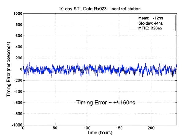
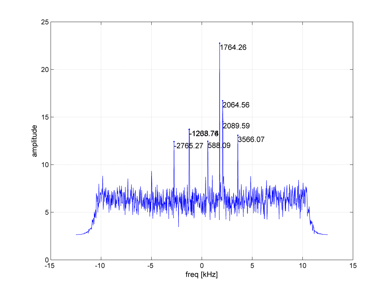
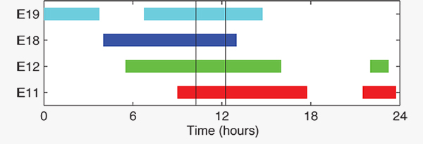
Results from new tests of the Satellite Time and Location (STL) service, using equipment configurations with a differential source and with a more accurate OCXO clock, show timing accuracy of 160 nanoseconds.
The STL service uses a signal from the low-Earth orbit (LEO) Iridium constellation.
In 2016, Satelles demonstrated sub-microsecond timing using a stand-alone TCXO-based receiver (see “Innovation: Navigation from LEO,” July 2017 GPS World).
New testing employed three different configurations of equipment, services and environment, including a Stanford Research Systems (SRS) rubidium vapor frequency reference, based on the PRS10 module, and a Satelles Evaluation Kit (EVK2) STL receiver, comprising a Maxim RF chip, Xylinx Spartan-3 FPGA, TI dual-core DSP chip, and internal OCXO (oven-controlled crystal oscillator) or external clock.
Parameters and equipment for the three tests are:
Optimal. Outdoor antenna, Rubidium clock powered on for months prior to data collection, receiver configured in static mode with a known location, and high-quality antenna.
Sub-optimal. Indoor antenna, Rubidium clock powered on six hours prior to data collection, receiver configured in static mode with an unknown location, and low-quality antenna.
Three independent receivers collecting data, receiver on-board OCXO, indoor antenna, receiver configured in static mode with an unknown location, low-quality antenna. Tests performed: 10 days with no local reference station running; 10 days with local reference station, 20-kilometers away from test receivers, providing timing corrections to STL ground segment.
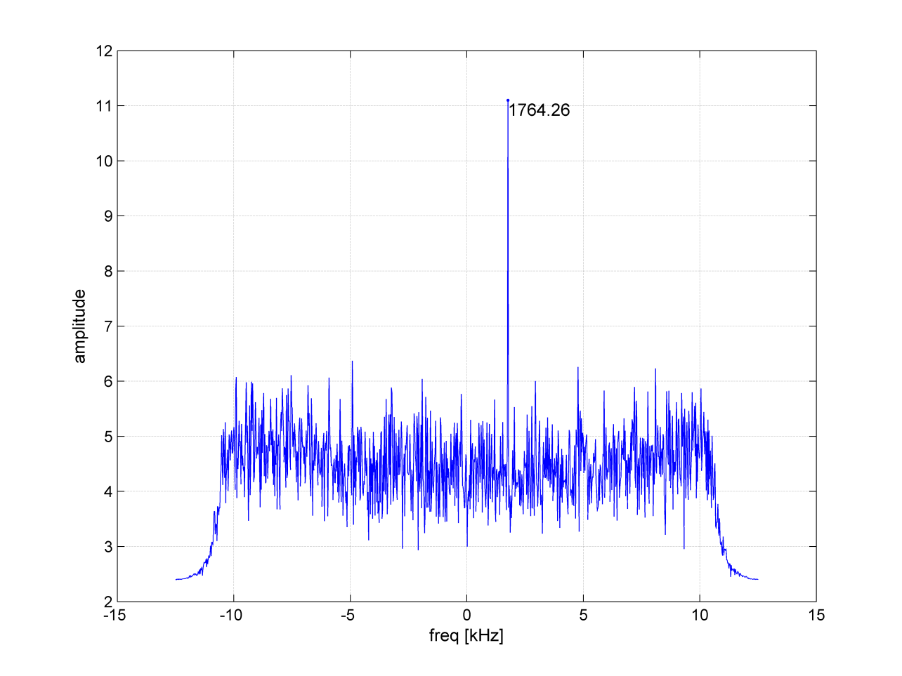
See Figure 1 for more extensive test results. Also see a previous article.
FIGURE 1. OCXO timing result with base station.
The 66-satellite Iridium LEO constellation transmits overlapping spot beams, which provide location-specific data that changes every few seconds.
Air Force Issues GPS III Follow-on Contract
The U.S. Air Force Space Command released its request for proposals to build 22 new GPS III satellites, called the GPS III Follow-On Phase 2 contract.
The contract will be awarded to a single bidder, and has an estimated dollar value of $10 billion including all options.
Phase 2 is planned as a single, predominantly fixed-price incentive-type contract awarded via full and open competition for production of 22 GPS III satellites. Deadline for proposals is April 16. Delivery of the first satellite is to be in 2026.
Phase 1 contracts awarded in May 2016 to Boeing, Northrop Grumman and Lockheed Martin (builder of the first 10 GPS III satellites) “determined that viable, low-risk, high-confidence sources exist to conduct a full and open competition for Phase 2, the production of 22 GPS III SVs [space vehicles] starting in the FY19 timeframe.”
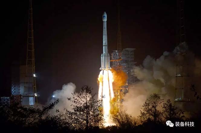
BeiDou’s Long March
On Feb. 12, BeiDou-3 28 and 29 were launched into medium-Earth orbits, following the launch of a pair of BeiDou satellites on Jan. 11. The satellites form part of a third phase of BeiDou deployment, taking BeiDou coverage from regional to covering the countries along the Belt and Road initiative by the end of 2018, and global by 2020.
China launched two BeiDou-3 navigation satellites into space on Jan. 12 as part of efforts to enable its BeiDou system to provide navigation and positioning services to countries along the Belt and Road by the end of 2018. The Belt and Road Initiative aims to create the world’s largest platform for economic cooperation, encompassing China, Southeast Asia, South Asia, Central and Western Asia, Middle East and Africa, and Central and Eastern Europe.
The twin satellites are coded MEO-7 and MEO-8, the 26th and 27th satellites in the BeiDou Navigation Satellite System. They are based on a newly developed dedicated satellite bus that features a phased-array antenna for navigation signals and a laser retro-reflector. They each weigh about one metric ton, and both have two deployable solar arrays; their design life is 12 years. This was the first BeiDou launch in 2018, which will see an intensive further launch schedule throughout the year.
In his December 2017 “Directions” article in GPS World, Changfeng Yang, chief BeiDou system architect, wrote that “Eighteen BD-3 MEO satellites and one BD-3 GEO satellite will be launched by around the end of 2018. Upon the deployment of those 19 satellites, BD-3 will possess the initial operational capability and serve the countries along the Belt and Road.”
This would bring the constellation to an initial operational capability before the end of this year. China targets completion of the fully operational global system in 2020.
More interference potential from another tower set
Satellite operator Iridium asked the Federal Communications Commission (FCC) in April 2017 to modify its license to add a new class of ground stations called Certus for expanded terrestrial, maritime and aeronautical operations.
Iridium’s 66-satellite constellation provides, in addition to mobile communications signals, the Satelles time and location service: microsecond timing accuracy and 20- to 50-meter unaided position accuracy worldwide (see the “Innovation” column, July 2017 GPS World).
GPSIA. The GPS Innovation Alliance (GPSIA) commented in September, “GPSIA seeks to ensure that radio navigation satellite service (RNSS) receivers operating in the 1559–1610 MHz band are adequately protected from out-of-band emissions (OOBE) generated from the new Certus mobile Earth station (MES) terminals that will operate on the second-generation Iridium satellite system.
“GPSIA and Iridium are actively engaged in constructive discussions regarding the adequacy of that protection, but no final resolution has yet been reached. [….]
“In the unlikely event that GPSIA is unable to reach an agreement with Iridium, it asks the commission to impose limitations on the operation of Certus terminal devices to protect GPS/RNSS operations in the 1559–1610 MHz band at a level equivalent to what terrestrial terminals in the same and other frequency ranges provide at –95 dBW/MHz.”
Hexagon. Hexagon, the parent company of GPS manufacturer NovAtel, commented on Jan. 8, “Certain statements in the modification application regarding output power and amount of terminals to be deployed cause great concern regarding the unimpeded operation of radio navigation satellite service (RNSS) receivers. The application does not include enough information to simulate the impact properly.
“Hexagon politely requests that the FCC will exercise the same due diligence [as] during previous modification applications close to the RNSS bands (for example docket 11-109) and establish a technical working group or a similar testing process that ensures unimpeded coexistence of the modified Iridium terminals with the established RNSS systems.”
Documents related to the case can be found here, on the FCC International Bureau website.
Galileo security center moves to Spain
The Galileo Security Monitoring Centre (GSMC) for the European Union’s Galileo satellite system will move from the United Kingdom to Madrid, Spain, as a result of Brexit.
The center, not yet fully operational, is expected to grow to a staff of as many as 30. It controls access to the satellite system and provides around-the-clock monitoring when the main security center near Paris is offline.
The GSMC is operated by the European GNSS Agency. It is one of a number of EU institutions leaving the UK as a result of the 2016 referendum vote.
Spain has another of the fundamental centers of the program, the Loyola de Palacio GNSS Service Center, also in Madrid.
Galileo satellites 9 and 10 are functioning perfectly, and the initial series of flight operations is continuing as part of the critical launch and early orbit phase, according to a European Space Agency Rocket Science blog by Daniel Scuka, senior editor for Spacecraft Operations at ESOC, ESA’s European Space Operations Centre, Darmstadt, Germany.
Galileo 9 and 10 lifted off together on Sept. 11 from Europe’s Spaceport in French Guiana atop a Soyuz launcher, bringing the total number of Galileo satellites in orbit to 10.
“The pair are being stepped through an intense series of check-outs, confirmations, mode changes, configurations and health verifications by the joint ESA/CNES mission team working around the clock at ESOC, Darmstadt, Germany,” according to the blog. “The team are now focusing on conducting a series of thruster burns designed to start the drift of the two satellites toward their target orbital positions.”
“Following the burns performed during the LEOP (launch and early orbit phase), the satellites will continue naturally drifting, ending up in their final desired operational orbits at about 23,222 km after another set of thruster burns, planned to achieve fine positioning in orbit, around the end of October,” said Liviu Stefanov, co-flight director from ESA.
With the excellent performance of the spacecraft and the ground teams, the LEOP is expected to wrap up soon.
All the Soyuz stages performed as planned during the September 11 launch, relieving anxieties tied to a faulty Soyuz launch in September of last year. The Fregat upper stage released the satellites into their target orbit close to 23,500 km altitude, around 3 hours and 48 minutes after liftoff.
“The deployment of Europe’s Galileo system is rapidly gathering pace,” said Jan Woerner, director general of the European Space Agency (ESA). “By steadily boosting the number of satellites in space, together with new stations on the ground across the world, Galileo will soon have a global reach. The day of Galileo’s full operational capability is approaching. It will be a great day for Europe.”
Two more Galileo satellites are scheduled for launch by end of this year. These satellites have completed testing at ESA’s ESTEC technical centre in Noordwijk, the Netherlands, with the next two satellites also undergoing their own test campaigns.
More Galileo satellites are being manufactured by OHB in Bremen, Germany, with navigation payloads coming from Surrey Satellite Technology Ltd in the UK, in turn utilizing elements sourced from all across Europe.
“Production of the satellites has attained a regular rhythm,” said Didier Faivre, ESA’s Director of Galileo and Navigation-related Activities. “At the same time, all Galileo testing performed up to now — including that of the ground segment — has been returning extremely positive results.
“And while the continuing deployment of Galileo remains our priority, along with exploitation of EGNOS — Europe’s already operational satellite navigation augmentation system — ESA is also looking farther ahead.
“With the European Commission, we are doing the technical work to ensure Galileo goes on forever — locking in continuity of Europe’s navigation services into the long term, to meet performance on a par with the other global satellite navigation systems.”
Next year Galileo deployment will be boosted by operation of a specially customized Ariane 5 launcher that can double, from two to four, the number of satellites that can be inserted into orbit with a single launch.
European SBAS Advances, Improves
After extensive ground and space testing, the SES-5 GEO satellite has entered into the European Geostationary Navigation Overlay Service (EGNOS) operational platform, broadcasting EGNOS Signal-In-Space (SIS). Replacing Inmarsat-4F2, SES-5 will ensure reliable EGNOS services until 2026, and will enable a range of performance improvements. In particular, EGNOS will offer even greater stability during periods of high ionospheric activity.
“SES-5 is the first step of the complete renewal of the EGNOS Space Segment, securing the EGNOS services for the next decade and the future transition to the dual-frequency multi-constellation services,” said Carlo des Dorides, European GNSS Agency executive director. “It will be completed by the introduction of the ASTRA-5B signals and the procurement of a new EGNOS payload which are both planned for 2016.”
SES-5, carrying EGNOS L1 and L5 band payloads, was launched in July 2012. The integration of a second EGNOS SBAS L1/L5 band payload on SES ASTRA-5B GEO satellite is currently ongoing. The introduction of the second SES GEO satellite for EGNOS is planned at the end of 2016.
GAO Report Spotlghts OCX Delays, Cost Increases
According to a report released by the U.S Government Accountability Office (GAO) on Sept. 9, titled “Actions Needed to Address Ground System Development Problems and User Equipment Production Readiness,” the Air Force has experienced significant difficulties developing the GPS next-generation operational control system (OCX). According to the report, completion of OCX will require $1.1 billion and four years more than planned to deliver OCX. The report Highlights section states, “The Air Force began OCX development in 2010,” and “accelerated OCX development in 2012 to meet optimistic GPS III satellite launch timeframes even as OCX development problems and costs grew, and then paused development in 2013 to address problems and resolve what it believed were root causes.
“However . . . OCX cost and schedule growth have persisted due in part to a high defect rate, which may result from systemic issues. Further, unrealistic cost and schedule estimates limit OSD visibility into and oversight over OCX progress. “ The full report may be read online.
During the course of development the Air Force made changes, updating the specifications for connections to other government systems and in the M-code signal requirements. Officials for Raytheon, the prime OCX contractor, estimated that, as a result of various modifications “nearly two-thirds of the requirements baseline as of [preliminary design review] had changed by mid-2012.” Subsequent software updates and modifications contributed to a high defect rate in the OCX software. “
If you have requirements change at the same time you’re developing the software, it’s more likely that you could have a higher amount of defects that you have to change after the fact,” said Matthew Gilligan, Raytheon’s vice president for navigation and environmental solutions.
China launched two BeiDou navigation satellites into medium Earth orbit on July 25.
China launched two BeiDou navigation satellites into medium Earth orbit on July 25.
The two new satellites, BeiDou-3 M1 and BeiDou-3 M2, are in orbital slots 1 and 6 of Plane 1 (or A Plane), respectively. The satellites are designated BDS M1-S and M2-S — the “S” may stand for “Test” (in Chinese: 试验 = Shiyan).
On Aug. 14, China stated one satellite was working autonomously and had set up a link with the other satellite, successfully testing the autonomous control technology of the Beidou constellation. The inter-satellite link realizes communication and distance measurement among satellites, bringing autonomous control of the system a step closer.
Autonomous navigation is the project’s key to global operation. It enables satellites to work independently, providing users with more accurate data, according to BeiDou design engineers.
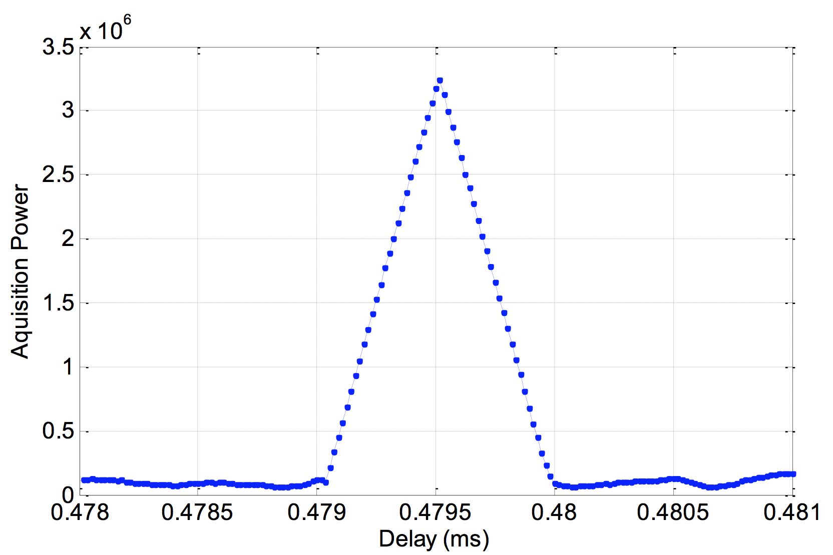
On Aug. 9, signals from the two new BeidDou satellites were received with a software-defined radio sampler operated at the European Commission’s Joint Research Centre in Ispra, Italy. The sampler is driven by orbit-prediction software that triggers a synchronized acquisition on both 1575.42 MHz and 1278.75 MHz using 1-bit complex samples at 60 megasamples per second (about 60 MHz total bandwidth). The two-line element sets for the orbits were obtained from the CelesTrak website, and predicted positions were computed using code developed following the Simplified General Perturbations Satellite Orbit Model 4 (SGP4) as documented in the U.S. Department of Defense Spacetrack Report No. 3.
To confirm the identity of the satellite being tracked using codeless tracking, we matched the measured Doppler frequency shift with the predicted one. The local oscillator clock drift was modeled using GPS L1 C/A-code signals and taken into account when matching the Doppler shift.
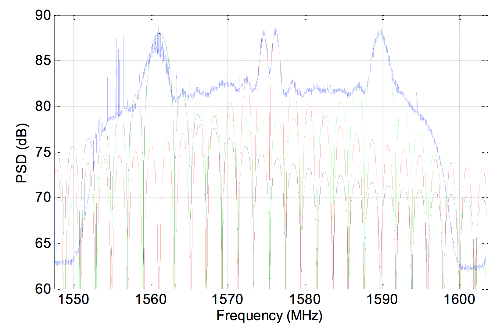
According to a presentation given at Stanford University’s 2014 PNT Symposium by Mingquan Lu and Zheng Yao from Tsinghua University, modernized BeiDou satellites broadcast an MBOC(6,1,1/11) [a multiplexing of BOC(6,1) and BOC(1,1) signals] and a BOC(14,2) signal on the L1 frequency. Neglecting the BOC(6,1) term, side lobes were brought to baseband and cross-correlated by our equipment. In Figure 1, the peak at 1756.41 MHz is BEIDOU-3 M2. This is also confirmed by cross-correlating the lobes of the BOC(14,2) signal, which is quite a unique feature of the new satellites (see Figure 2).
On Aug. 10, a 1.8-meter dish was pointed at the satellite, and a Tektronix RSA306 USB Real Time Spectrum Analyzer was used to sample the signal on L1 with 14-bit resolution at 112 megasamples per second. The resulting power spectrum is shown in Figure 3.
Figure 3. Power spectral density of BEIDOU-3 M2 on L1.
The spectrum shows very good overlap between the anticipated BOC(1,1) signal in red, BOC(14,2) in green and BPSK(2) in black. In fact, PRN33 correlates with the low side lobe suggesting that the satellite is also broadcasting a legacy signal on 1561.098 MHz (see Figure 4).
Figure 4. Cross-correlation of a BPSK(2) BeiDou code PRN33 on a 1561.098-MHz carrier.
Meanwhile, tracking by stations participating in the International GNSS Service Multi-GNSS Experiment has established that the second recently launched BeiDou Phase 3 MEO satellite is using PRN code 34, and that the first Phase 3 satellite, BeiDou I1-S launched on March 30, 2015, into an inclined geosynchronous orbit, is using PRN code 31.
In a late June filing with the Federal Communications Commission (FCC), Lightsquared asked the agency to reassign its spectrum licenses — which were at the root of a prolonged dispute in 2010 and 2011, and have never been fully utilized — to a new licensee that would be wholly owned by a new company, New LightSquared. This is part of LightSquared’s efforts to re-emerge from bankruptcy.
LightSquared wants to resume its own interference testing scheme, floated in 2011 after an independent, collaborative effort found ample LightSquared interference with GPS. The company has contracted with Roberson and Associates, a technology consulting firm, to develop its interference study.
LightSquared is being represented before the FCC by Reed Hundt, a former FCC chairman who served from 1993 to 1997.
LightSquared listed 28 different GPS receivers and related devices that it wants to test for interference with its terrestrial mobile broadband service. The devices include certified and non-certified aviation receivers and avionics equipment, general location, cell phones and 13 different high-precision clocks and receivers.
Hundt specificaly identifed three companies — Trimble, Garmin, and John Deere — that he wants to come forward and provide proprietary technical and business information “in confidence” to tester Roberson. In statements to the FCC, Hundt twice used the phrase “speak now or forever hold your peace.”
In March of this year, LightSquared obtained U.S. court permission to exit bankruptcy protection, which it entered in 2012. At that time, the FCC had concluded, after lengthy testing, hearings, charges and countercharges, that the wireless broadband service proposed by LightSquared would interfere with GPS signals and associated positioning, navigation, and timing.
New LightSquared reportedly has $1.25 billion in operating funds to help “make full use of its spectrum to provide existing and innovative services.”
In a recent trial involving the assets of the bankrupt company, the value of its spectrum bands was estimated at possibly $4.5 billion or higher.
GPS Industry Response. The GPS Innovation Alliance responded in early July to media reports on LightSquared’s position regarding the testing of the compatibility of terrestrial broadband and GPS.
Following is the GPS Innovation Alliance’s response:
“The GPS Innovation Alliance (GPSIA) supports a consensus-driven process, including all government and non-government stakeholders, to clearly identify and address remaining technical issues raised by LightSquared proposals to repurpose mobile satellite spectrum for terrestrial broadband use.
“The technical challenges posed by these proposals are formidable, as evidenced by the conclusions of multiple U.S. government entities. Specifically, the U.S. Departments of Defense and Transportation and the NTIA have all found in the last several years that LightSquared’s proposals have significant potential to interfere with GPS.
“Contrary to LightSquared’s recent suggestions, this is not simply a private matter between three GPS companies and LightSquared, but is important to all GPS users who rely on this critical technology every day. The Department of Transportation has sponsored an ongoing effort to assess adjacent band issues, and the GPS industry is actively engaged with the Federal Communications Commission (FCC), Department of Transportation (DOT) and other government stakeholders to drive consensus around next steps.
“While we welcome the participation of LightSquared consultants, any further analysis of the technical issues should be informed by input from all of the relevant stakeholders, rather than the one-off efforts of an interested party.”
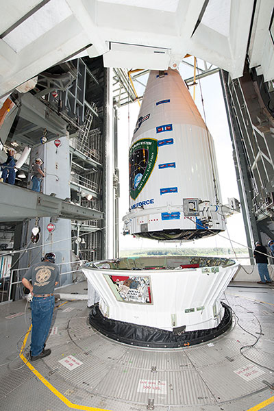
Tenth GPS Block II Follow-On Satellite Rises Above
This one’s in orbit now. Photo shows the nose cone containing GPS IIF-10 being lowered into position atop the launch vehicle, inside the rocket gantry at Cape Canaveral.
The tenth GPS IIF satellite lifted off from the Space Launch Complex (SLC)-41 at Cape Canaveral, Fla., on schedule at 11:36 local time (15:36 UTC) — at the start of a nineteen-minute window.
Later that same day, United Launch Alliance (ULA) officials declared the launch mission a success. The Centaur upper stage completed its second burn and released the GPS IIF-10 satellite into the navigation network to complete the launch of the Atlas 5 rocket.
This is the second of three GPS constellation replenishment flights planned in 2015. The first launch, of GPS IIF-9 using a Delta IV rocket, occurred on March 25. A third launch, of GPS IIF-11 using an Atlas rocket, is scheduled for Sept. 22. The launch of GPS IIF-12 is scheduled for Jan. 26, 2016.
The Boeing-built GPS IIF-10 is one of the next-generation GPS satellites, incorporating various improvements to provide greater accuracy, increased signals, and enhanced performance for users. GPS IIF-10 was the 70th spacecraft to be launched as part of the GPS constellation and the tenth in the Block IIF series that began launching in May 2010.
GPS IIF-10 marks the 55th Atlas V launch since the vehicle’s inaugural launch in 2002 and the 27th flight of the 401 configuration. Every operational GPS mission has launched on a United Launch Alliance or heritage rocket. While the government has certified ULA competitor SpaceX for GPS III launches, a SpaceX Falcon 9 rocket exploded June 29, two minutes after launch of an International Space Station resupply mission.
The Boeing-built GPS IIF satellites provide improved signals to support both the warfighter and the growing civilian needs of the global economy, the U.S. Air Force said in a statement. The GPS IIF satellites will provide improved accuracy through advanced atomic clocks, a longer design life than previous GPS satellites, and a new operational third civil signal (L5) that benefits commercial aviation and safety-of-life applications. It will also continue to deploy the modernized capabilities that began with the GPS IIR satellites, including a more robust military signal.
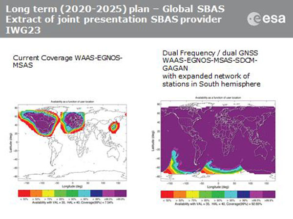
Current coverage (left) of WAAS, EGNOS and MSAS; long-term 2020–2025 (right) plan for dual-frequency, dual-GNSS WAAS-EGNOS-MSAS-SDCM-GAGAN.
SBAS Agree to Common Message
Aircraft navigation and safety will benefit from enhanced, reliable satellite navigation signals on a seamless basis across much of the world in the 2020–2025 timeframe. The 28th Satellite-based Augmentation Systems Interoperability Working Group (IWG) came to agreement on standardization of satellite-based augmentation systems (SBAS) in a meeting hosted by the European Space Agency in early April. The group planned a shift from reliance exclusively on GPS to a multi-constellation design employing Galileo, BeiDou and GLONASS after 2020.
The agreement centers around a message definition for a new secondary SBAS channel — to be known as L5, along with the current L1 — for second-generation SBAS systems, which will utilize dual-frequency multi-constellation signals, greatly increasing the accuracy of navigation systems available to airliners by largely eliminating ionospheric errors. Plans also call for an expanded network of stations in the Southern Hemisphere. The IWG document must now be accepted by the official international SBAS standardization bodies: the International Civil Aviation Organisation, the U.S. Radio Technical Commission for Aeronautics (RTCA) and the European Organisation for Civil Aviation Equipment.
The meeting also reported on the state of development of the other global SBAS systems. Along with the four operational systems — the U.S. WAAS, European EGNOS, Japan’s Multi-functional Satellite Augmentation System (MSAS) and India’s GAGAN (GPS and geo-augmented navigation system) — these comprise South Korea’s KASS, China’s Beidou SBAS, Russia’s System for Differential Corrections and Monitoring (SDCM) and the West African Agency for Aerial Navigation Safety in Africa and Madagascar (ASECNA) SBAS.
UAV Integration into Airspace
The Federal Aviation Administration (FAA) announced two new initiatives related to unmanned aircraft systems (UAS) at the Association for Unmanned Vehicle Systems International (AUVSI) Unmanned Systems 2015 conference in Atlanta, Ga., in early May.
FAA Administrator Michael Huertatold a large gathering of national journalists, “The unmanned aircraft industry is changing faster than any segment in the aircraft industry. A new project to harness that energy, the Pathfinder program, is partnering with three leading U.S. companies to expand unmanned aircraft operations in the United States.” The FAA is working with industry partners on three focus areas:
CNN will research visual line of sight (LOS) operations for newsgathering in urban areas. CNN will continue working with Georgia Tech University to improve newsgathering for all organizations.
PrecisionHawk will investigate agricultural operations for rural areas, flying outside LOS.
BNSF Railway, second-largest freight railroad network in North America, will undertake inspection of rail infrastructure, also beyond visual LOS.
Huerta said that the partners, collectively, “are trying to push the envelope, what can we accommodate safely and what can we learn from that.We’ll test a little, learn a little, then test some more. How do we see a staged implementation? To integrate unmanned aircraft, but to do it safely. We’re trying to push the edges of what we can allow, working with partners who have specific uses and resources.”
As to a timeframe to reach new UAV regulations, he replied, “I can’t comment a lot on the rule itself, but it’s fair to say that in the rulemaking comment process [closed on April 24], we received more than 4,500 comments. It’s too early to say how those comments will shape the final rulemaking.
“Assessment will be done in the coming months, perhaps by the end of the year, but that’s an aggressive timetable. That’s not accomplished in six months, nor should it take a million years.”
New Airbus EGNOS-Capable
The new Airbus A350 airliner, now entering service, comes fitted with EGNOS. The EGNOS system is being adopted by European airports to enable satellite-guided landing approaches. The A350’s Satellite Landing System allows pilots to perform precision-landing approaches guided by EGNOS or its U.S. equivalent, WAAS. The capability offers vertical landing guidance down to a minimum of 60 miles.
New Galileo Satellite on the Air
Monitoring by researchers at the German Aerospace Center (Deutsches Zentrum für Luft- und Raumfahrt, or DLR) indicates that one of the Galileo full-operational-capability (FOC) satellites launched on March 27 has begun transmitting standard L-band signals using pseudorandom-noise-code identifier 22.
The first E1 and E5 signals from GSAT0204, also known as FOC-FM4 and Galileo 8 and as NORAD object 40545, were received at an International GNSS Service Multi-GNSS Experiment tracking station in Windhoek, Namibia, at about 11:32 UTC May 21. The satellite’s signals were subsequently tracked by a station in Wettzell, Germany, and then by others.
The signals will be set unhealthy for use until satellite commissioning is completed.
News item courtesy of CANSPACE Listserv.
Euroship Gets eLoran as Backup
Container ship in port.
Ship management company EuroShip Services Ltd. has installed eLoran as a backup to GPS to ensure the safety of its vessels operating off the coast of the United Kingdom.
The trial installation may lead to implementation across the full fleet of16 vessels managed by Euroship, working routes in Northern Europe. The land-based radio navigation system is intended to seamlessly take over in the event of a GPS outage. EuroShip plans to simulate GPS outages to test eLoran provision of position, navigation and timing data automatically.
New GPS III RFP
The U.S. Air Force (USAF) has released a draft Request for Proposal for GPS III Launch Services, encompassing launch vehicle production, mission integration and launch operations.USAF reintroduces competition into the Evolved Expendable Launch Vehicle (EELV) program after more than a decade.
GPS III is the first of nine launches the Air Force intends to competebetween now and 2017, followed by 25 more from 2018 to 2022.
Planet Earth gained five new navigation satellites in late March, for four satellite systems.
GPS. The U.S. Air Force’s ninth GPS Block IIF satellite (GPS IIF-9) launched on March 25 from Cape Canaveral, Fla. The IIF-9 rode aboard a Delta IV rocket, the workhorse of the GPS fleet for successful launches. The satellite was declared operational on April 21.
“Many thought the Delta IV and GPS days were long gone, but the recent questions concerning reliable and proven launch vehicles have brought them back online, so to speak,” said GPS World Defense Editor Don Jewell. “The 20-year milestone for GPS space vehicles on orbit that occurred on April 27 translates to approximately 500 orbital years just for the IIR and IIF constellations alone. The IIAs may account for that many orbital hours as well.
“This is by far the most successful launch record ever put together by any nation or government. No other space-faring nation even comes close. The U.S. Air Force and all the players should be proud of all these records and more, plus we have one more GPS asset on orbit, providing GPS signals to the world and all they enable, courtesy of the USAF.”
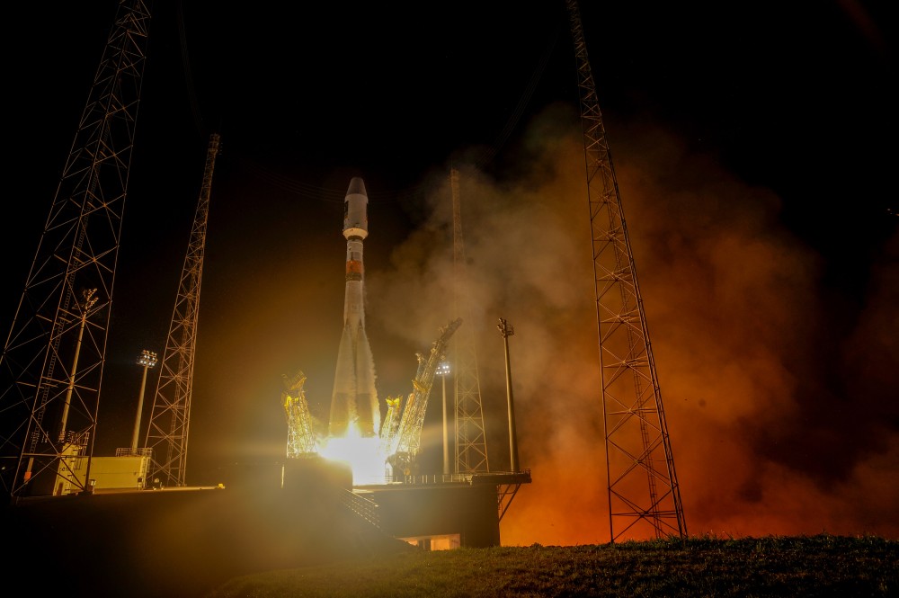
Galileo. Two days later, March 27, a duo of Galileo satellites was successfully launched from Europe’s Spaceport in French Guiana. The seventh and eighth Galileo satellites rode aboard a Soyuz ST-B rocket. Both are in their planned orbits.
IRNSS. The next day, March 28, the fourth satellite (IRNSS-1D) ofthe IRNSS satellite navigation constellation was launched onboard PSLV-C27, and reached its orbital slot April 9. The Polar Satellite Launch Vehicle blasted off from the Satish Dhawan Space Center on India’s east coast, in the 28th consecutive successful PSLV mission.
BeiDou. On March 30, China launched the first of a new generation of navigation satellites, BeiDou-3 M1, for its BeiDou constellation. BeiDou-3 M1 is the first of 17 next-generation Beidou navigation satellites. It will have a new navigation signal system with inter-satellite links and other tests to verify the satellite navigation system. The new series of satellites is expected to mark an advancement in the completion of Beidou Phase III several years ahead of schedule, by as soon as 2017 rather than 2020.
GLONASS. Not making the March launch cut, GLONASS kept its hat in the orbit ring, so to speak, by issuing some far-sighted predictions. Nicholas Testoyedov, CEO of Information Satellite Systems Reshetnev, said that the first GLONASS-K2 spacecraft will be launched into orbit in 2018. “New code division (CDMA) signals will be emitted, so it will provide more accurate positioning for users.”
The GLONASS budget for 2015 will be cut by more than 5 billion rubles, a drop of more than 10 percent. GLONASS is also suffering through an embezzlement scandal, related to construction of a new ground control center.
Galileo’s worldwide ground segment as of March 2013.
Galileo Ground Upgrade
On April 9, the European Space Agency announced completion of a full-scale hardware and software migration to version V2.0 of its global Ground Mission Segment providing all Galileo navigation messages. The Ground Mission Segment was turned off Jan. 26, allowing the migration to take place over the month of February. March was taken up with detailed checking by operations and system, concluding in a final check on March 31 to validate the successful migration.
“The upgrade has provided better overall performance and availability, along with improved robustness, security and operability,” explained Martin Hollreiser, overseeing mission segment development for ESA, with Thales Alenia Space France as prime contractor. “An overall 25 percent performance improvement is confirmed.
“Three new sensor stations, Kiruna, Ascension and Azores — used to monitor the satellite navigation signals — were added to the operations chain, as well as a new uplink station in Papeete, to uplink corrections incorporated in the navigation message to the satellites for broadcast to the users.”
The Ground Mission Segment at its core is determining the exact satellite orbits and synchronizing all the satellite and terrestrial elements of that clock: the relevant control center is linked to a global network of ground stations (sensor and uplink stations). The Galileo signals currently undergo technical testing, with early services for the public projected for 2016. “A further update is foreseen for the end of this year,” Hollreiser added, although this will occur with no interruption of services.
GPS Glitch Dates from 2011
On April 15, the U.S. Air Force GPS Directorate said data analysis shows that a technical error affecting some GPS IIF satellites first appeared in 2011. The error affects the way the ground control system builds and uploads messages transmitted by the satellites, but does not affect the accuracy of GPS signals. It involves the ground-based software used to index messages. “A GPS message indexing issue was recently identified that affects a limited number of active GPS IIF satellites, but does not degrade the accuracy of the GPS signal received by users around the globe. The result is an occasional broadcast not in accordance with U.S. technical specifications. ”
April marks the 20th anniversary of GPS FOC. U.S. Air Force Space Command declared Full Operational Capability (FOC) for the GPS constellation April 27, 1995, signifying the system met all requirements with 24 operational Block II/IIA satellites in their assigned orbital slots and providing both the military Precise Positioning Service (PPS) performance standard and the civil Standard Positioning Service (SPS) performance standard.
FOC was formally announced on July 17, 1995.
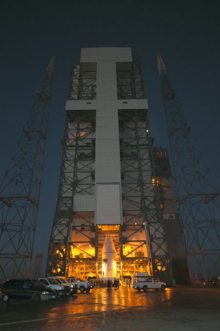
GPS IIF-9 Launch on March 25
As this magazine went to press on March 19, the U.S. Air Force’s ninth GPS Block IIF satellite (GPS IIF-9) was being readied for a March 25 launch [since successfully launched]. The satellite was encapsulated in the Delta IV rocket’s 4-meter-diameter nose cone at a processing facility, and moved to the launch pad at Space Launch Complex 37 for mating to its booster inside the mobile service tower.
Launch is scheduled for March 25 at 2:36 p.m. U.S. Eastern time from Space Launch Complex 37 at Cape Canaveral Air Force Station, Fla. GPS IIF-9 marks the 29th Delta IV launch and the 57th operational GPS satellite to launch on a ULA or heritage launch vehicle.
CNAV Performance Compares Favorably to Legacy Signals
A March 5 announcement concerning the new L2C and L5 GPS civil signals states: “CNAV Message Types 10, 11, 30 and 33 are currently transmitted on seven GPS IIR-M (L2C) and eight GPS IIF satellites (L2C and L5). A Modernized Navigation (MODNAV) Tool integrated with the GPS ground control software (Architecture Evolution Plan or AEP) is generating the CNAV data messages. Daily CNAV uploads began December 31, 2014, and the U.S. Air Force reports that signal performance of CNAV matches or slightly outperforms Legacy performance: average user range error (RMS URE) from 25 February – 3 March 2015 was 0.50 m for Legacy and 0.57 m for Modernized; best week for Modernized signals since the broadcast initiated April 2014 was 0.42 m for 6 – 13 January 2015.
“Users are reminded that these CNAV signals are ‘pre-operational’ and should be used with discretion until they become fully operational; the L5 message is currently set unhealthy,” concluded Rick Hamilton, CGSIC Executive Secretariat, USCG Navigation Center, in a status email to the Civil Global Positioning System Service Interface Committee (CGSIC).
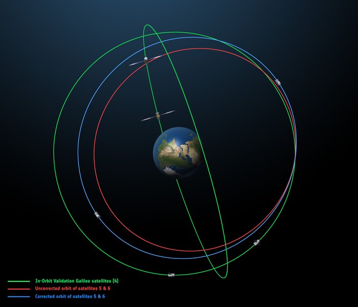
Galileo Six, Seven, Eight: Lay Them Straight
The original (in red) and corrected (in blue) orbits of the fifth and sixth Galileo satellites, along with that of the first four satellites (green).
On March 17, some stations participating in the International GNSS Service Multi-GNSS Experiment acquired E1 and E5a signals from Galileo 6 (FOC-FM2, GSAT0202). The satellite is using pseudorandom noise code E14.
This development follows the successful repositioning of the sixth Galileo satellite into a corrected orbit, which will now allow detailed testing to assess the performance of its navigation payload. A 20-meter-diameter antenna at the European Space Agency’s (ESA’s) Redu center in Belgium will study the strength and shape of the navigation signals at high resolution.
Launched with the fifth Galileo last August, its initial elongated orbit saw it traveling as high as 25,900 kilometers above Earth and down to a low point of 13,713 kilometers — confusing the Earth sensor used to point its navigation antennas at the ground.
A recovery plan was devised between ESA’s Galileo team, flight dynamics specialists at ESA’s ESOC operations centre and France’s CNES space agency, as well as satellite operator SpaceOpal and manufacturer OHB. This involved gradually raising the lowest point of the satellites’ orbits more than 3,500 km while also making them more circular.
The fifth Galileo entered its corrected orbit at the end of November 2014. Both its navigation and search-and-rescue payloads were switched on the following month to begin testing. Now the sixth satellite has reached the same orbit.
This latest salvage operation began in mid-January and concluded six weeks later, with 14 maneuvers performed in total. Its corrected position is effectively a mirror image of the fifth satellite’s, placing the pair on opposite sides of the planet. The exposure of the two to the harmful Van Allen Belt radiation has been greatly reduced, helping to ensure future reliability.
The corrected orbit means they will overfly the same location on the ground every 20 days. This compares with a standard Galileo repeat pattern of every 10 days, helping to synchronize their ground tracks with the rest of the constellation.
“I am very proud of what our teams at ESA and industry have achieved,” said Marco Falcone, head of the Galileo system office. “Our intention was to recover this mission from the very early days after the wrong orbit injection. This is what we are made for at ESA.”
The decision whether to use the two satellites for navigation and search-and-rescue purposes will be ultimately made by the European Commission, as the system owner, based on the in-orbit test results and the system’s ability to provide navigation data from the improved orbits.
March 27 Launch Date for Galileo Seven, Eight
The seventh and eighth Galileo satellites, set for launch together on March 27, were placed onto the Fregat upper stage of their Soyuz ST-B launcher in mid-March. [The satellites have been successfully launched.]
The Fregat stage will hold the satellites in place during their four-hour flight into orbit 22,300 kilometers above the Earth. Then, at the correct altitude, the two satellites are sprung away in opposing directions.
The Fregat upper stage was blamed for theAugust mis-delivery of Galileo satellites five and six. The root cause of the anomaly producing the wrong orbits was a shortcoming in the system thermal analysis performed during stage design, according to findings by an independent inquiry board.
The anomaly occurred during the flight of the launcher’s fourth stage, Fregat. It occurred about 35 minutes after liftoff, and was due to a temporary interruption of the joint hydrazine propellant supply to the Fregat thrusters. The interruption in the flow was caused by freezing of the hydrazine, resulting from the proximity of hydrazine and cold helium feed lines, these lines being connected by the same support structure, which acted as a thermal bridge. Ambiguities in the design documents allowed the installation of this type of thermal bridge between the two lines.
IRNSS Launch Scheduled for March 29
The launch of the fourth satellite for the Indian Regional Navigation Satellite System, previously scheduled for March 9, was postponed until March 29 at 13:00 UTC, due to the replacement of a faulty telemetry transmitter on the satellite. [The satellite has been successfully launched.]
IRNSS-1D will be fourth in the seven-spacecraft IRNSS constellation.
BeiDou, Too, in Late March
There are indications that the first satellite in the BeiDou Phase 3 expansion may be launched by the end of March [since successfully launched]. Apparently, a BeiDou satellite has been shipped to the Xichang launch site, and tracking ships have left port for the open ocean. Also, a philatelic first day cover for the launch (a common Chinese practice) has been issued with a March 2015 inscription. This is likely a launch of a medium Earth orbit (MEO)satellite.
Where It All Began for Galileo and EGNOS
The European Space Agency issued a press information notice on June 11, 1995 — in the same timeframe as the GPS FOC announcement noted on the previous page — titled “Europe’s Contribution to a Navigation Satellite System.”
“The European Commission, the European Space Agency (ESA), and the civil aviation organisation EUROCONTROL have agreed to cooperate on a joint programme).The European Satellite Navigation (ESN) Action Programme, elements of which are GNSS-1 [First Generation Global Navigation Satellite System] and GNSS-2, is planned to run for five years (from mid-1995 to mid-2000) with a budget of the order of 150 million euros.
“National aviation authorities and the parties involved in the action programme see Europe’s commitment to satellite navigation as being of strategic significance for the future.
“The main objective of the programme is to develop technologies that will ensure that data from the two existing Global Navigation Satellite Systems — the United States’ GPS and Russia’s GLONASS — which are both under military control, will also be available for civil use on a reliable basis and will provide the requisite precision.In parallel, studies will be conducted in order to make preparations for a second generation satellite-navigation and positioning system (GNSS-2), to be deployed as from 2005.
“In the first phase (GNSS-1), ESA’s contribution to the joint action programme will be EGNOS [European Geostationary Navigation Overlay Service].Satellites stationed in geostationary orbit at an altitude of about 36,000 km will relay to aircraft, shipping or road vehicles information that will enable the recipients to determine their actual positions with greater precision than is possible by using GPS/GLONASS data alone.Civil users of those systems receive artificially degraded data deviating by about 100 metres.EGNOS, will enable in particular, to increase the number of satellites that can be seen by a given user within the geostationary broadcast area.
“Around the period 2005–2008, after completing a trial period, the new system is due to be used as sole means.”
Galileo, Previously GNSS-2
“It is planned to develop GNSS-2 in the period between 2005 and 2020, building on experience acquired under GNSS-1.From the technical viewpoint, the second generation will be a considerable improvement on the first in terms of reliability, precision and availability.
“However, if Europe were to confine itself to developing the relevant technologies, its industry would have only a very slim chance of being involved in the construction of the satellites for the system or in the control and user segments for a second-generation civil system (GNSS-2). Given that U.S. and Russian firms are the current leaders in this area, it is necessary for strategic reasons for Europe to carry out a comprehensive development and demonstration programme as it must be able to prove it has the requisite capabilities before GNSS-2 becomes operational, which, in the experts’ opinion, will be from 2005.
“The time schedule foreseen for the different steps can be summarised as follows:
GNSS-1 mission analysis and definition studies: mid-1995 to mid-1996
European GNSS-1 pre-operational mission (task 1): to end 1997. Development of the geostationary network, following the Inmarsat III launch and first ranging demonstration phase
GNSS-1 (task 2): 1996 to end 1998. In parallel to the development of the network, the Ground Integrity Channel will be set up, followed by a second demonstration phase
GNSS-1 (task 3): 1997 to early 2000. Wide Area Differential service for precision approaches to be set up and tested
Introduction of GNSS-1 as sole means: 2000/2003.”
GPS World is indebted to Richard Langley’s CANSPACE archive of historical documents for this note of interest.
The United States Civil GPS Service Interface Committee (CGSIC) has issued a notice about a problem some receivers are having implementing the correct time. The U.S. Coast Guard Navigation Center has received reports of synchronization issues since the implementation of a leap second on Jan. 21. Users experiencing this problem should contact the receiver manufacturer for a firmware or software update. Here is the text of the CGSIC notice:
All CGSIC: 2015 GPS Future Leap Second Implementation
The GPS 50 bit-per-second navigation message transmitted by each GPS satellite (specifically Page 18, subframe 4) includes the parameters needed to relate GPS time to UTC (Coordinated Universal Time).That relationship is maintained through leap second implementation transitions by IS-GPS-200 compliant user equipment.For leap second transition, user equipment must utilize the notice regarding a scheduled future delta time due to leap seconds (ÄtLSF), together with the week number (WNLSF) and the day number (DN), at the end of which the leap second becomes effective.
On or about Jan. 21, 2015, those GPS navigation messages began to include futurevleap second data which indicates an increase in the leap second to become effective at the end of June 2015.IS-GPS-200 revision H, dated 24 Sep 2013 paragraph 20.3.3.5.2.4 Coordinated Universal Time (UTC), documents the appropriate algorithm details to ensure correct utilization of the parameters above (including all potential truncated week number transitions and variations in time of processing relative to satellite upload timing near the future leap second effectivity).
The data upload for the June 30 leap second, initiated with SVN48/PRN07 at 18:33:56z on Jan. 21, was correctly executed. However, there are several receivers brands/models that seem to be mishandling this information and applying the leap second now. This is creating a negative one-second offset in faulty receivers. The U.S. Coast Guard Navigation Center has reports of these receivers causing synchronization issues with radios, computer systems, and data logging equipment.
Users experiencing issues with GPS receivers that began on Jan. 21 should contact the receiver manufacturer to determine if the latest firmware or software patch can correct the issue.
The third and fourth Galileo Full Operational Capability (FOC) satellites are a confirmed “fit” for their Arianespace Soyuz launch March 27, having made initial contact with the mission’s dual-payload dispenser in French Guiana, according to Arianespace.
The fit check was completed over a two-day period inside the Spaceport’s S1A payload preparation building. The two satellites were installed separately, with the Flight Model #3 (FM3) spacecraft integrated on — and subsequently removed from — the dispenser on Feb. 9. Flight Model #4 (FM4) underwent the same process the following day.
The payload dispenser for Galileo was developed by RUAG Space Sweden for Arianespace, and carries one satellite on each side. It will deploy the spacecraft during the Soyuz launch by firing a pyrotechnic separation system to release them in opposite directions at the orbital insertion point.
Final integration on the dispenser will be performed during upcoming processing at the spaceport, and will be followed by the completed unit’s installation on Soyuz.
The March 27 mission — designated Flight VS11 in Arianespace’s numbering system — will be the company’s fourth launch carrying spacecraft for the Galileo constellation.
Air Force Orders Two More GPS III Satellites
The United States Air Force plans to order two more GPS III satellites from contractor Lockheed Martin. Lockheed Martin is under contract to build eight GPS III satellites, with the first planned to be launched in 2016. The contract includes options for up to four more satellites.
However, the Air Force plans to open up construction of subsequent GPS satellites for competitive bidding with GPS III space vehicle 11. The satellites are part of the Air Force’s $167.3 billion budget request for fiscal 2016, up from $152.8 billion provided by Congress for fiscal 2015.
The Air Force also intends to buy only one GPS satellite — from Lockheed Martin or a different contractor — in 2017 rather than the three included in the current budget blueprint.
Milena, or Galileo-FOC FM2, moves above the dangerous Van Allen Belt to rejoin Doresa, Galileo-FOC FM1, in a partially usable orbit. Photo: Galileo
By Tim Reynolds, GPS World European correspondent
Director General Jean-Jacques Dordain of the European Space Agency (ESA) announced Jan. 16 that the second errant full-operational capability (FOC) satellite, launched in August, had started its orbital change maneuver the previous day. He anticipated that the orbital change would be completed and the final orbit — “albeit somewhat lower in height than the one into which it was supposed to go” — achieved in “a few weeks.” He confirmed that both in-orbit FOCs work well, are fully operational, and provide excellent on-spec positioning data.
Two more FOC satellites are ready for launch, and a third has undergone thermal vacuum testing. Dordain said four will be available to launch soon, and he anticipated up to six FOCs being ready for launch in 2015 [word came at press time that all 2015 launches would be aboard the previously problematic Soyuz vehicle, and not on heretofore reliable Ariane]. The previous plan had called for four in 2015, but the total now includes two that were held back from a December 2014 launch. The actual schedule and launch vehicles are still under discussion, according to Dordain; the European Commission (EC) will make a decision at the end of January on this. He refused to comment on what ESA would recommend to EC on this front.
Read Tim Reynolds’ Brussels-based reporting the in EAGER quarterly enewsletter; free at gpsworld.com/subscribe.
The completion is a key milestone towards end-to-end capability to automatically transfer data between Raytheon’s OCX and Lockheed’s GPS III satellite. One more readiness exercise, five launch rehearsals, and a mission dress rehearsal are planned before launch of the first GPS III with OCX.
The exercise demonstrated mission planning and scheduling capabilities with the simulated Air Force Satellite Control Network (AFSCN) for the first time, including a replan scenario that would occur in the event of a launch slip.
The system also automatically generated antenna pointing angles for the simulated AFSCN — until now, manually generated. Exercise 4 introduced maneuver planning and reconstruction capabilities, as well as advanced planning and scheduling with AFSCN assets. Automation of these capabilities will allow GPS operators to optimize system performance rather than focus on routine operations.
Brigadier General Cooley
Colonel William Cooley, director of the GPS Directorate, has been nominated to the rank of brigadier general, United States Air Force. He wrote a December GPS World article on “What It Takes to Make a Gold Standard.”
Will Be Employable for Surveying, Precise Positioning, and Geodesy
By Peter Steigenberger and André Hauschild, German Aerospace Center (DLR) / German Space Operations Center
The first Full Operational Capability (FOC) Galileo satellite started transmitting L-band navigation signals on November 29, 2014. Based on data collected by a global network of GNSS tracking stations of the Cooperative Network for GNSS Observation (CONGO) and the Multi-GNSS Experiment (MGEX) of the International GNSS Service (IGS), we determined that an E1 signal with pseudorandom noise code (PRN) E18 was first tracked at the station LLAG (La Laguna, Tenerife, Canary Islands) at 06:08 UTC. A few moments later, the satellite’s transmissions were also tracked at other MGEX stations including the E5a, E5b, and E5 AltBOC signals. Based on the computed satellite visibility at various tracking stations, the satellite could be positively identified as GSAT0201, also known as Galileo FOC-FM1 or Galileo 5 with COSPAR ID 2014-050A and NORAD ID 40128.
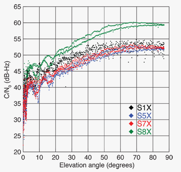
FIGURE 1 shows the carrier-to-noise-density ratio (C/N0) of the E18 signals tracked at the CONGO/MGEX station SIN1 (Singapore, using a Trimble NetR9 receiver with a Leica AR25.3 antenna). We selected the signals from this station for analysis due to an E18 pass occurring close to the zenith and covering almost the full range of elevation angles. The E5a and E5b signals (S5X and S7X RINEX identifiers) show very similar performance, whereas the C/N0 values of the E1 signal are 1–2 dB-Hz higher. The C/N0 values of the E5 AltBOC signal (S8X) reach 60 dB-Hz at high elevation angles, which is about 6 dB-Hz higher than the other signals.
Figure 1. Galileo E18 carrier-to-noise-density ratio for the CONGO/MGEX station SIN1 (Singapore).
The first pair of Galileo FOC spacecraft was launched on August 22 with a Soyuz launcher from the Guiana Space Centre, Kourou, French Guyana. Due to a malfunction of the Fregat upper stage, the satellites were injected into elliptical orbits with an inclination of about 49° instead of near circular orbits with 55° inclination. In November, the perigee of the first FOC satellite was raised by about 3,500 kilometers by a series of 11 maneuvers with a corresponding reduction in orbit eccentricity from 0.23 to 0.16.
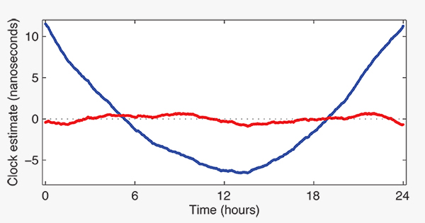
E18 has been included in the precise orbit and clock solutions of the MGEX analysis center at Technische Universität München (TUM) in Munich, Germany, since December 5. FIGURE 2 shows the detrended estimates of the active Galileo E18 clock for December 7. The presence of a pronounced quadratic term as well the large drift of 33.9 microseconds per day indicate that the active clock is a rubidium atomic frequency standard rather than a more precise passive hydrogen maser. The FOC satellites carry two of each kind of clock.
Figure 2. Galileo E18 clock estimates for December 7, 2014, with respect to the hydrogen maser at the Ottawa IGS station (NRC1) after removing an offset and drift (blue) or a second order polynomial (red).
The TUM orbit and clock product allows researchers to again compute dual-frequency positioning solutions using only Galileo observations, as the In-Orbit Validation satellite E20 has not transmitted an E5 signal since May, when a power anomaly left the satellite with the capability to only transmit an E1 signal. Furthermore, E20 currently does not transmit a navigation message.
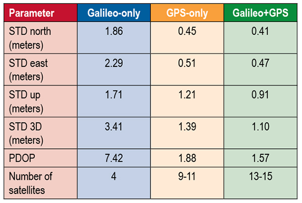
TABLE 1 shows the scatter of single-point positioning using pseudorange (code) observations from the MGEX station MAS1 (Maspalomas, Gran Canaria, Canary Islands) for a Galileo-only, a GPS-only, and a combined Galileo+GPS solution for December 6. At an elevation cut-off angle of 10°, four Galileo satellites were visible from 10:15 until 12:25 UTC (see FIGURE 3). The GPS-only solution covers the same time interval. The start time is not limited by the cut-off angle but an E18 transmission outage from 3:45–10:15 UTC.
TABLE 1. Single point positioning results for the MGEX station MAS1 (Maspalomas) for December 6, 2014.Figure 3. Galileo visibility at the MGEX station MAS1 (Maspalomas) on December 6, 2014. The time period considered in the single-point positioning is indicated by vertical lines.
We used an ionosphere-free linear combination of Galileo E1 and E5 AltBOC code observations and GPS L1 and L2 code observations with a 30-second sampling interval. As the Galileo-only solution suffered from position dilution of precision (PDOP) values of up to 830, a total of 32 epochs with PDOP values greater than 25 were excluded. The geometry of the remaining epochs is still pretty unfavorable. At a mean PDOP value of 7.4, the standalone position solution exhibits a 3D standard deviation (STD) error of 3.4 meters. Use of the Galileo satellites in a combined GPS+ Galileo solution improves the positioning performance. In particular, the height component benefits from the inclusion of the four Galileo satellites with a standard deviation improvement of 25 percent.
Despite the orbit injection error, the new Galileo FOC satellite has now been successfully activated and added to the Galileo constellation. Unfortunately, the current orbit is incompatible with the standard Galileo almanac format, which may cause restrictions for some commercial receiver types.
Nevertheless, the satellite can already be tracked by a wide range of geodetic receivers with existing firmware versions and it will, in fact, be possible to use the new satellite for diverse applications in surveying, precise positioning, and geodesy, as well as in general multi-GNSS studies. We now look forward to the activation of the second FOC satellite, which can be expected in early 2015 and will, for the first time, offer multi-frequency signals from a total of five Galileo satellites.
Sanctions Delay GLONASS-K2
According to Nikolai Testoyedov, the CEO of Information Satellite Systems Reshetnev, manufacturer of the GLONASS satellites, the company will now produce nine GLONASS-K1 satellites.
“For a smooth transition to a multi-functional group and due to issues with the very complex GLONASS-K2 satellites, we decided to continue with the GLONASS-K1 intermediate range of satellites, and we are preparing for the launch of nine units of this series,” he said.
He recalled the original plan was to launch two K1 satellites and then move to GLONASS-K2 satellites.
“In the beginning, really, we wanted after the two GLONASS-K1 satellites No. 11 and 12, to go for the launch of more advanced GLONASS-K2 devices. But, unfortunately, the plans had to be adjusted somewhat because of the sanctions restricting the delivery of radiation-resistant electronic components from the West. We have to put a hold on the in-depth development of technical and technological documentation and that delays us in terms of moving ahead by at least a year or two,”he said.
Reported by the Russian magazine Vestnik GLONASS, and relayed by Richard Langley’s CANSPACE listserv.
GNSS Mandates Would Violate Trade Agreements
A U.S. government representative stated at an international satnav forum that mandating use of specific GNSS services for applications such as air-traffic control, freight shipments, emergency calling, and road tolling could violate the terms of World Trade Organization (WTO) agreements that many nations, including all six GNSS providers, have signed.
Regional mandates already exist for GLONASS in Russia and BeiDou in China, and have been suggested and extensively discussed in Europe, as a way of stimulating the market adoption of Galileo receiver chipsets, thus recouping some of the massive public investment in the satnav system.
The presentation occurred during the Ninth Meeting of the International Committee on Global Navigation Satellite Systems (ICG), held Nov. 10–14, 2014, in Prague, Czech Republic.
Jason Kim, a senior policy analyst at the U.S. Department of Commerce, stated that the United States and the European Union already enjoy a productive dialog on GNSS trade issues under the 2004 U.S.-EU Agreement on GPS-Galileo Cooperation. In that agreement, both parties agreed to consult before establishing GNSS standards, certification requirements, regulations, mandates; affirmed their non-discriminatory approach with respect to GNSS trade; and established a working group to consider non-discrimination and other trade related issues.
Finally, the United States and the European Union recognized and reiterated in 2004 their commitments to WTO rules including those governing technical barriers to trade, specifically, that there would be no goods discrimination based on non-tariff measures such as regulations, standards, testing, or certification.
Kim made the remarks in the course of his presentation titled “GNSS Market Access.” He told GPS World that his presentation was directed less at the European Union, which has been conscientious of its WTO commitments, and more towards the rest of the ICG members, including non-provider nations that may be asked by GNSS providers to mandate specific systems.
“To promote adoption of their systems,” Kim stated, “GNSS providers are considering/implementing equipage mandates for various applications: aviation, motor-carrier and HAZMAT vehicle tracking, car accident reporting (eCall/ERA-GLONASS), and emergency phone calls (E112).
“The United States recommends technology-neutral, performance-based standards,” Kim continued, giving as example the U.S. E911 rules that specify a required positioning accuracy and then allow wireless carriers to choose the best technical solutions according to their lights.
The U.S. government presentation at ICG revealed particular concern that regulations under consideration could adversely affect the sales of U.S. GPS-enabled hardware in many industry sectors. All members of the WTO, including the six GNSS providers on the ICG, are bound to a range of trade agreements designed to promote open-market access, all cited in the Prague ICG presentation: the General Agreement on Tariffs and Trade (GATT), the Agreement on Technical Barriers to Trade (TBT), and the General Agreement on Trade in Services (GATS). The United States, Europe, Japan, and 12 others are also parties to the WTO Agreement on Government Procurement (GPA).
European Commission officials have publicly and recently stated that they are considering how to stimulate Galileo use, in particular through regulatory measures requiring that navigation equipment be installed on aircraft, automobiles, and other platforms.
“Requiring specific systems arbitrarily prevents or penalizes imports of goods having perfectly functional GNSS capability,” said Kim. “WTO members must comply with TBT obligations in setting technical regulations.”
He concluded his presentation by requesting that the ICG Providers’ Forum add GNSS market access to its future agenda for discussion, and consider developing a new principle on market access for future adoption.
Bridge of the Galatea, a GLA vessel that carries a eLoran receiver and conducted tests of the new system. Photo: GLA
Back-up to Vulnerable GPS Signals Required for Busy Shipping Lanes
The General Lighthouse Authorities (GLAs) of the UK and Ireland announced October 31 the initial operational capability of UK maritime eLoran. Seven differential reference stations now provide additional position, navigation, and timing (PNT) information via low-frequency pulses to ships fitted with eLoran receivers. The service will help ensure they can navigate safely in the event of GPS failure in one of the busiest shipping regions in the world, with expected annual traffic of 200,000 vessels by 2020.
Ships carry 95 percent of UK trade, accounting for its strongly expressed concerns regarding GPS vulnerability to jamming and spoofing, and the leadership role it has taken in eLoran research and testing. The UK is the first country in the world to deploy the technology along its coastline, thronged with both passenger and cargo services. Deployment involved replacing the existing radio receiver equipment in two prototype reference stations at Dover and Harwich, and the creation of five new reference stations in the Thames, Humber, Middlesbrough, and Firth of Forth and Aberdeen in Scotland, on the North Sea where oil-laden vessels come from deep-sea drilling rigs.
Entirely independent of GPS, eLoran can provide navigation information for vessels as well as the timing data necessary to maintain the power grid, cell phones, financial networks, and the Internet in the event of an outage. Unlike space-based navigation, eLoran signals can also reach inside buildings, underground, and underwater.
Captain Ian McNaught, deputy master of Trinity House, commented, “eLoran provides a signal around 1 million times more powerful than those from satellite signals, providing resilience from interference and attack. The achievement of initial operational capability for the system at Dover and along the east coast of the UK is a significant milestone, providing for improved safety aboard appropriately equipped vessels. The maritime industry would now benefit from the installation of eLoran receivers on more vessels to take advantage of improved navigational safety.”
“Telecoms, finance, energy, and other industries, which are subject to significant issues caused by the loss of timing signal provided by GPS, are recommended to take advantage of the enhanced reliability now available to address the over-dependence of key national infrastructure on vulnerable satellite systems,” McNaught said.
eLoran technology is based on longwave radio signals and is independent and complementary to GPS.
Several other nations are consulting with the UK GLAs on eLoran. South Korea wants to establish an eLoran alliance with the UK while it pursues its own rollout of differential eLoran reference stations and new eLoran transmitters based on the latest technology. In 2012, South Korea was the victim of a 16-day GPS jamming attack by North Korea.
Full operational capability covering all major UK ports is expected by 2019.
Galileo Roving High
The fifth Galileo navigation satellite, one of two left in the wrong orbit in August, made a series of November maneuvers as a prelude to its health being confirmed. The aim was to raise the lowest point of its orbit — its perigee — to reduce the radiation exposure from the Van Allen radiation belts surrounding Earth, as well as to put it into a more useful orbit for navigation purposes.
Should the two-week operation prove successful, the sixth Galileo satellite will follow the same route, according to the European Space Agency (ESA).
The Galileo pair, launched together on a Soyuz rocket on August 22, ended up in an elongated orbit traveling out to 25,900 kilometers (km) above Earth and back down to 13,713 km. The target orbit was a purely circular one at an altitude of 23,222 km. Also, the orbits are angled relative to the Equator less than originally planned.
The two satellites have only enough fuel to lift their altitude by about 4,000 km — insufficient to correct their orbits entirely. But the move will take the fifth satellite into a more circular orbit than before, with a higher perigee of 17,339 km.
“The new orbit will fly over the same location every 20 days,” said Daniel Navarro-Reyes, ESA Galileo mission analyst. “The standard Galileo repeat pattern is every 10 days, so achieving this will synchronize the ground track with the rest of the Galileo satellites.”
“In addition, from a user receiver point of view, the revised orbit will reduce the variation in signal levels, reduce the Doppler shift of the signal, and increase the satellite’s visibility,”Navarro-Reyes said. “For the satellite, reducing its radiation exposure in the Van Allen radiation belts will protect it from further exposure to charged particles. The orbit will also allow Galileo’s Earth Sensor to hold a stable direction for the satellite’s main antenna to point at Earth. Right now, when the satellite dips to its lowest point, Earth appears so large that the sensor is unusable. The satellite relies on gyroscopes alone, degrading its attitude precision.”
The recovery is being overseen from the Galileo Control Centre in Oberpfaffenhofen, Germany, with the assistance of ESA’s Space Operations Centre, ESOC, in Darmstadt, Germany. France’s CNES space agency is providing additional ground stations so that contact can be maintained with the satellite as needed, ESA said.
Welcome IIF-8
The U.S. Air Force launched the eighth GPS IIF satellite on October 29, aboard an Atlas V 401 rocket. With this new arrival on orbit, only four more Block IIF satellites remain to be placed aloft. Three are in storage awaiting launch, and one is in production.
The Boeing-built GPS IIF-8 (SVN-69/PRN-03) will replace SVN-51 in the E plane slot 1. SVN-51 will be re-phased from E1 to an auxiliary node at E7 somewhere around SVN-54 currently on station at E4, according to the Air Force Second Space Operations Squadron (2 SOPS).SVN-38/PRN-08 will be taken out of the operational constellation prior to SVN-69 payload initialization and sent to Launch, Anomaly Resolution and Disposal Operations (LADO).PRN-08 will be assigned initially to SVN-49 and set to test.
SVN-51 will remain in an auxiliary node once it completes its re-phase journey. The SVN-51 re-phase will take about six months after the initial burn occurs.