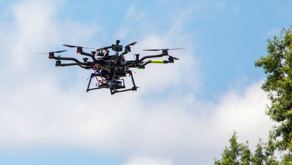
NASA researchers at Langley Research Center in Hampton, Virginia, have successfully flown multiple UAVs beyond visual line of sight (BVLOS) with no visual observer. The UAVs dodged one another and successfully maneuvered around obstacles before safely landing, the agency said. NASA conducted the tests to help researchers someday create autonomous, self-piloted helicopters that could carry passengers and cargo through busy aerospace.
Researchers used multiple Alta 8 UAVs loaded with software designed to enable autonomous flights. Although monitors observed the flights from a remote-control room at Langley, the UAVs successfully operated BVLOS.
NASA is also testing elements of autonomy using helicopters. They are designed to contribute towards the development of autonomous helicopters that can take off and land from “vertiports,” and transport passengers and cargo over both short and long distances.
The experiments are part of the agency’s Advanced Air Mobility Mission (AAM), which is designed to enable safe autonomous flight and integrate newly developed vehicles into the national airspace. The mission will “set the stage for a flourishing industry” of electric air taxis and UAVs by 2030, NASA says on its AAM website.
NASA will transfer the technology created during this project to the public to ensure industry manufacturers can access the software while designing their vehicles.
uAvionix has partnered with Civil Air Patrol (CAP) to deploy a DO-260B-compliant, dual-band Automatic Dependent Surveillance-Broadcast (ADS-B) receiver network to complement Federal Aviation Administration (FAA) sensor data with low-altitude aircraft positions in support of CAP’s radar analysis mission.
The ADS-B receiver technology — already in use in Virginia — is designed to shorten the accident-to-rescue time in the National Radar Analysis Team’s search and rescue efforts.
Through the leadership of CAP’s Virginia Wing, members throughout the state have assisted uAvionix in locating suitable receiver sites and supported the installation of small, low-weight FlightStation ADS-B receivers at various airports.
The dual-mode (1090 MHz and 978 MHz) FlightStations receive transponder data from aircraft, which is centrally received and transmitted to the radar team server at Maxwell Air Force Base, Alabama, where it’s combined with FAA sensor data.
The CAP team uses FAA data and advanced technologies in its search and rescue efforts. The team is activated by the Air Force Rescue Coordination Center when there is a report of a possible missing aircraft or crash. Once the team is activated, analysis and actionable data can be provided in minutes to an incident commander, instead of the days or hours required before the team’s creation.
The FlightLine roll-out consists of several ATC grade ADS-B receivers with overlapping coverage, allowing for validation of transmitted ADS-B data and pinpoint multilaterated positions. Traditional ADS-B and radar concentrate mostly on airports and higher altitudes in support of air traffic control.
Most other available data sources largely exclude coverage for 978Mhz transponders, typically used by general aviation aircraft. Virginia is the first state in the U.S. to have complete coverage down to 500 ft of altitude. The new ADS-B is rapidly expanding to other CAP wings across the U.S.
“The introduction of ADS-B has resulted in a significant improvement of general aviation safety,” said Christian Ramsey, managing director, uAvionix. “Expanding on the FAA coverage at lower altitude and for UAT [universal access transceiver] transponders typically carried by general aviation will further enhance the tools used in safety of life activities such as CAP’ ‘s emergency services mission.”
The radar analysis team is calling on all CAP Squadrons to volunteer to host and install additional receivers where additional coverage is needed. Young said his team will prioritize areas where existing coverage is weak.
For more information and to register your squadron for a FlightStation unit, click here.
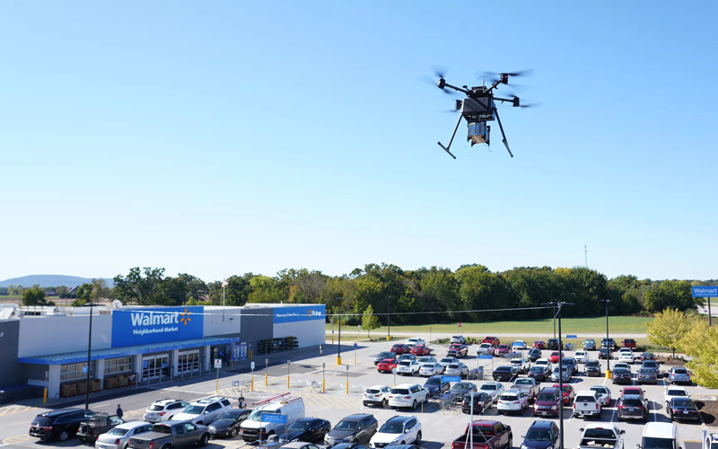
Two Walmart locations in Utah, one in Lindon and one in Herriman, are now providing UAV delivery for customers nearby. Walmart has UAV deliveries operated by DroneUp, Flytrex and Zipline at 36 stores in the United States.
For a $3.99 fee, customers within a mile of the stores can receive their groceries via UAVs. The two Walmart locations in Utah can deliver more than 120 times per day and each UAV can carry up to 10 pounds. The hubs for deliveries are in the parking lots of each Walmart location and are operated by Federal Aviation Administration-certified pilots.
Walmart is using UAV delivery in seven states, including Florida, Arizona, Texas, Utah, Virginia, North Carolina and Arkansas. The most common products delivered include ice cream, lemons, rotisserie chicken, Red Bull and paper towels, according to Walmart.
Walmart drone deliveries launched in October 2019 in Arkansas. In 2022, Walmart completed more than 6,000 deliveries across all 36 participating locations.
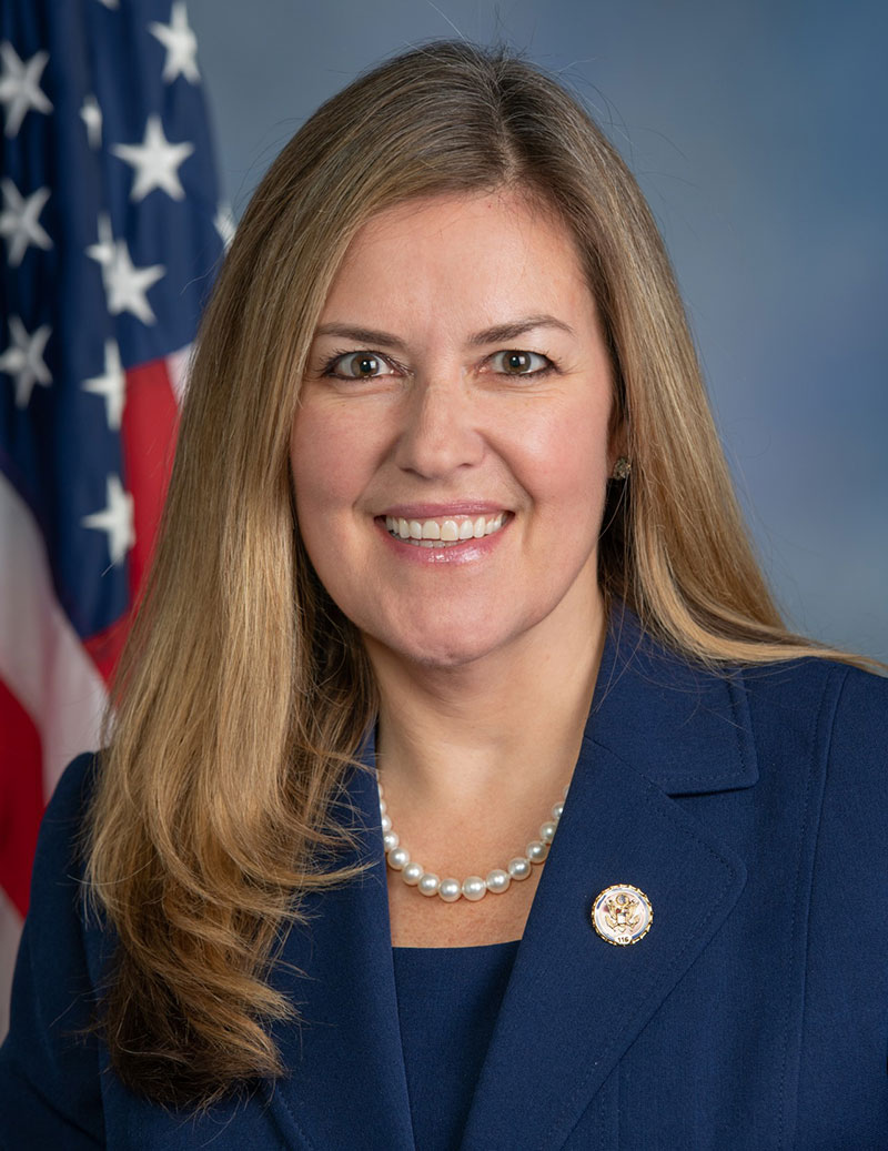
Reading her biography, you might not think that Jennifer Wexton, U.S. Representative for Virginia’s Tenth District, would be very connected to technology issues. As an attorney and government leader, she has spent a lot of time advocating for families, veterans and federal workers.
Yet she is also co-founder of the Congressional Task Force on Digital Citizenship and has become an advocate for protecting the nation’s vital positioning, navigation and timing (PNT) services.
“We all use GPS every day whether we know it or not, and we need to ensure it stays the gold standard for satellite navigation,” she said. “But as the National Security Council said last year, it has become a single point of failure for America. So much of our critical infrastructure depends on GPS, from the navigation apps on our phones to the military to our financial and energy sectors, and it is past time that we address its critical vulnerabilities and develop and implement reliable backup technologies.”
Wexton says that she has been aware of and concerned about the issue almost since the day she took her seat in Congress.
“I am a member of the House Appropriations subcommittee that oversees funding for the Department of Transportation, and civil GPS and PNT issues fall squarely in DOT’s jurisdiction,” she said. “In 2018, Congress passed a law requiring DOT to ensure we have a backup for GPS, and we updated that law earlier this year to ensure that all appropriate types of technologies are included in this effort. I don’t know how we can be comfortable with autonomous drones and self-driving cars if we don’t have technologies in place to support and back up GPS. They are certainly available.”
The fact that her district includes a huge swath of Virginia’s high-tech corridor has added to her knowledge of the problem and range of possible solutions. In addition to many big names in technology and government contracting, several smaller companies focusing on resilient PNT have offices in her district. These include Echo Ridge, Hellen Systems, Satelles and UrsaNav. All four participated in the Department of Transportation’s Complementary PNT and GPS Backup Technologies Demonstration.
Adding to her concern are increasing threats to GPS satellites and signals. At a recent hearing with DOT Secretary Pete Buttigieg, she mentioned Russia’s anti-satellite tests and ongoing GPS jamming in Ukraine as examples.
“And that might not even be the worst of it,” she later said. “We need to be cognizant of Chinese capabilities in cyber and in space. They have shown how they can physically grab one satellite with another and toss it out of orbit.”
At the hearing, she gently prodded Secretary Buttigieg about DOT’s progress toward protecting the nation.
“…in the FY-22 Omnibus we created a program which is housed at DOT and provided $15M to help develop the needed requirements and standards and conduct additional testing. […] How’s it going?”
Buttigieg temporized saying the department was working on the Congressional tasking in the appropriation with the funding available. That tasking focused on testing and developing standards as opposed to contracting for signals to begin making one or more alternatives to GPS widely available for adoption.
Funding for such an effort has been problematic since a 2018 law required DOT to establish a timing backup for GPS. Administrations have justified inaction by saying that Congress had not funded the effort. Yet hill staff report that for several years administration representatives vigorously opposed any funding at all during annual budget development negotiations. The $15M to establish the program within DOT this fiscal year, which Wexton supported, was the first time any allocation had been made.
Rep. Wexton is also a big supporter of GPS modernization. “GPS is the gold standard for satellite navigation and America’s gift to the world,” she said. “We have to continually modernize it to support both military and civil uses. That’s a no-brainer.”
She also sees deploying alternative timing and navigation systems a step to making GPS more secure. “Unlike the Russians and Chinese, we don’t have one or more systems widely deployed domestically if GPS is unavailable for some reason. This makes GPS satellites and signals prime targets for our adversaries, terrorists, and criminals. Having one or more alternatives will create redundancy and make GPS a much less attractive target.”
Providing one or more alternatives that could be widely adopted could be a relatively inexpensive proposition for the government, certainly when compared to the cost for GPS. More than $2 billion was appropriated for GPS operations and modernization this year. Industry sources estimate that contracts for the suite of alternative PNT sources described in the 2021 DOT report would cost a small percentage of that.
Dana A. Goward is President of the Resilient Navigation and Timing Foundation.
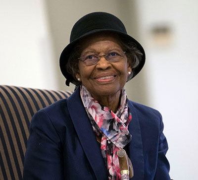
Trimble has established a scholarship program to honor Gladys West, a pioneer in mathematics, minority advancement and the advent of the Global Positioning System — one of the most widely used innovations throughout the world.
Gladys West. (Photo: Trimble)
Supported by the Trimble Foundation, a donor-advised fund, the Dr. West scholarship program will enable Virginia State University, North Carolina A&T State University and Florida International University to award a four-year scholarship to one student each year. These universities were carefully chosen to reflect Dr. West as a woman of color and science, and to align with two of the Trimble Foundation’s key support pillars: female education and empowerment and diversity, equity and inclusion.
Known today as the hidden figure who helped invent GPS, West knew from a young age that education would be the key to moving forward from her family farm in rural Virginia. A scholarship recipient herself, she earned a bachelor’s and master’s degree in mathematics.
She was offered a position in 1956 with Virginia’s Naval Proving Ground — now called the Naval Surface Warfare Center. Hired as a mathematician, she was one of only four African American employees at the time and only the second woman of color.
With her intelligence and computational skills recognized, she quickly climbed the ranks and became project manager for the Seasat radar altimetry project in the 1960s. Knowledge gained through that work enabled her to program an IBM computer to calculate an accurate geodetic Earth model — the detailed mathematical model of the shape of the Earth that is the essential building block for GPS.
That tenacity, talent and enterprising fortitude encapsulates the spirit of Trimble’s scholarship program designed to honor West’s contributions to science and the geospatial industry.
“It’s fitting to announce this special scholarship program following West’s 91st birthday,” said Rob Painter, Trimble CEO, “a woman who helped pave the path to GPS — the technology that was not only core for Trimble’s early business but provided the catalyst to create the geospatial industry. This path to innovation has given us the tools to not only navigate and model our world, but to transform work in our lives every day. Just as West viewed education as the pathway for the future, we are excited by the opportunity to support a new generation of stars to help them pursue their educational journey.”
“We must appreciate our past, learn in the present and prepare those behind us for the future,” West said. “We must encourage our youth to pursue a higher level education so that they will be equipped to change the world. We must be willing to use our talents and strengths to work for the betterment of the world.”
Virginia State University — West’s alma mater and a Historically Black College and University (HBCU) — will award the Dr. Gladys West “Constellation” Scholarship from Trimble to a student in the College of Engineering and Technology. The VSU scholarship is also being matched by an anonymous donor.
North Carolina A&T State University — a top-ranked public HBCU — will award the Dr. Gladys West HBCU Scholarship from Trimble to a student in the College of Engineering.
Florida International University — a minority-serving institution — will award the Dr. Gladys West Trimble Technology Lab Scholarship to a first-generation student in the College of Engineering & Computing. The scholarship is also being matched. FIU is the home to the recently established Trimble Technology Lab, which provides students hands-on access to Trimble technologies within the Moss Department of Construction Management.
Audi of America, the Virginia Department of Transportation (VDOT) and Qualcomm Technologies Inc. are planning for initial deployments of cellular vehicle-to-everything (C-V2X) communication on northern Virginia roadways.
C-V2X employs advanced wireless communications to enhance vehicle safety by using the same portion of the 5.9-GHz band that the Federal Communications Commission (FCC) has proposed to allocate for C-V2X.
In line with the Federal Department of Transportation’s announcement to establish a First Responder Safety Pilot Program, the organizations’ combined efforts are designed to focus on improving safety for construction workers and motorists.
The initial deployment is expected to take place on select roadways in Virginia beginning in the third quarter of this year.
C-V2X will be used to deliver work zone warnings on highways as well as signal timing information on approaches to signalized intersections on arterial roadways. In both cases, C-V2X communications can help deliver critical safety messages between vehicles and infrastructure with minimal latency, while less time-sensitive alerts are designed to be provided via C-V2X using the cellular network.
Photo: Audi
The initial deployments are aimed at expanding safety use cases in the connected vehicle safety spectrum established by the FCC, with the aim to curtail road hazards and fatalities. In a given year, traffic fatalities in the U.S. exceed 36,000 people.
The initial deployment is designed for connected-car systems designed to
boost safety around school buses,
warn motorists about dangerous road conditions,
alleviate congestion at traffic chokepoints and curbsides,
help improve the performance of automated vehicles that are nearing commercialization
The northern Virginia initial deployment involves two primary use cases:
Work zone warnings, which the organizations feel is an important use case on highways, featuring a Qualcomm 9150 C-V2X chipset solution via an in-vehicle display in Audi Q8 SUVs designed to deliver a graduated warning, with the last link being a low-latency, reliable warning to drivers of the workers’ physical presence.
On arterial roadways, the signal phase and timing (SpaT) from a traffic signal, will be transmitted with a Qualcomm 9150 C-V2X chipset solution to Audi Q8 SUVs. These vehicles have the Audi Traffic Light Information (TLI) service that can provide drivers a countdown to the green light. C-V2X from the traffic signal can also provide direct information to the Audi Q8, which will be used by the TLI system to fine-tune the countdown information of the signal phase and timing.
“VDOT has long supported research into the benefits of connected and automated vehicles, particularly those aspects that have the potential to significantly enhance safety,” said Virginia’s Director of Transportation Research and Innovation Cathy McGhee. “The inclusion of shorter-range, direct communication in the 5.9 GHz band using C-V2X is exciting, as it can allow us to evaluate this emerging communication option for essential and practical safety and mobility services, including saving the lives of maintenance and construction personnel in work zones.”
Photo: Audi
“We recognize the immediate value of the spectrum that the FCC proposed to allocate to C-V2X, and we endeavor to show our V2X equipped cars on real roads engaging in how transportation safety and mobility could be jump-started,” said Anupam Malhotra, Director, Connected Vehicle Services, Audi of America. “We are excited about our participation in this pilot deployment as it highlights the broad societal advantages that technology is now poised to deliver through the full 5.9 GHz V2X spectrum near term with far, far more to come as connected and automated vehicle fleets emerge over the next decade.”
Audi’s Traffic Light Information V2X services operate in 25 cities and nearly 10,000 intersections nationwide, including more than 1,700 intersections in the Washington D.C. metropolitan region.
“Qualcomm Technologies is excited to work with the VDOT, through its partner Virginia Tech and Audi to support the C-V2X use cases on the very same spectrum that the FCC has proposed to allocate for C-V2X. Qualcomm Technologies has long been a pioneer in the connected car with over 20 years of experience delivering in-vehicle telematic systems,” said Jim Misener, senior director, product management, Qualcomm Technologies, Inc. “With the advances in cellular communications now enabling us to also offer direct connectivity for safety services, traffic efficiency and emerging automated use cases, we are pleased to work closely with VDOT, Audi of America and Virginia Tech to showcase the commercial maturity and technological sophistication of C-V2X and to start the proliferation of the technology on U.S. roadways.”
The Virginia Tech Transportation Institute (VTTI) will develop the software and systems to support the primary use cases defined for the initial deployment. Following software development, the institute will then conduct a demonstration of C-V2X technology operating in these use cases.
C-V2X Features and Benefits
The C-V2X solution used in this initial deployment is based on third-generation partnership project (3GPP) Release 14 and Release 15 specifications. Direct communication of this solution uses 20 MHz from the 5.905 – 5.925 GHz ITS band, the same spectrum that the FCC has proposed allocating for C-V2X.
A more advanced mode of C-V2X has an evolution path to 5G using 3GPP Release 16 specifications.
Field test results issued by the 5G Automotive Association (5GAA) have proven C-V2X to be an efficient and effective radio access technology, showing that it significantly increases in range and reliability compared to other radio technologies.
C-V2X commercial products are now widely available in the form of multiple chip platforms, wireless modules, vehicular Onboard Units and infrastructure Roadside Units.
C-V2X encompasses both direct short-range communications that operate in the 5.9GHz ITS band and longer-range network communications delivered by mobile network operators; chipsets now offer both direct and network connectivity in the same solution concurrently, aiding in the adoption of the technology.
For more information about the Traffic Light Information technologies on Audi models in select markets, visit www.media.audiusa.com.
For Black History month in February, the Free-Lance Star of Fredericksburg, Virginia, profiled a woman few of us know about — Gladys West.
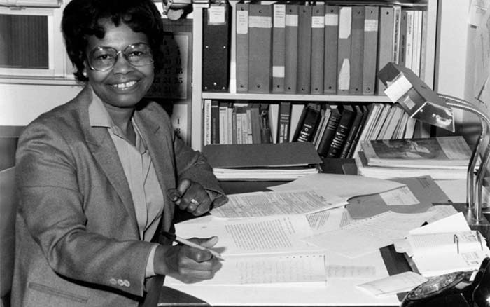
Capt. Godfrey Weekes, then-commanding officer at the Naval Surface Warfare Center Dahlgren Division, described to the newspaper the “integral role” played by West.
Gladys West’s work helped develop the Global Positioning System. (Photo: U.S. Navy)
“She rose through the ranks, worked on the satellite geodesy and contributed to the accuracy of GPS and the measurement of satellite data,” he said. “As Gladys West started her career as a mathematician at Dahlgren in 1956, she likely had no idea that her work would impact the world for decades to come.”
West collected data from the satellites, focusing on information that helped to determine their exact location as they transmitted from around the world. Data was entered into large-scale super computers that filled entire rooms, and she worked on computer software that processed geoid heights (precise surface elevations).
As a girl growing up in Dinwiddie County, Virginia, Gladys knew she didn’t want to work in the fields or a tobacco factory like her parents did.
“I was ecstatic,” she said of her career. “I was able to come from Dinwiddie County and be able to work with some of the greatest scientists working on these projects.”
Jim Colvard, technical director at NSWC Dahlgren from 1973 to 1980, knew West as a student in his graduate program and as a professional employee. “She was an excellent student and a respected and productive professional,” he wrote in an email. “Her competence, not her color, defined her.”
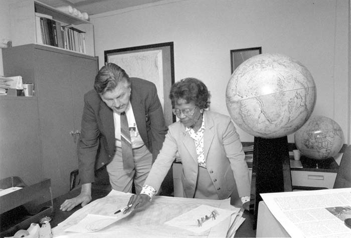
Gladys West, at Dahlgren with Sam Smith in 1985, looks over data from the Global Positioning System she helped develop. (Photo: U.S. Navy)
Drone experts will join with those from the medical field in a demonstration July 17 in Wise, Va. The event, “Let’s Fly Wisely,” aims to show how unmanned aerial systems (UAS) can alleviate the problem of health care access while creating economic opportunity for communities.
Many people in Virginia and across rural America are beyond reach of essential health services and basic supplies, ranging from bandages to medicine, according to event organizers. The drones will deliver essential medical supplies to an annual medical clinic held at the Wise County Fairgrounds every summer, organized by Remote Area Medical (RAM) USA and the Health Wagon.
At the clinic, thousands of medical specialists provide free eye, dental and health care services to people in urgent need, in what event organizers say is the largest free health care outreach in the nation.
The UAS used for the demonstration will be a completely autonomous rotorcraft, designed by Flirtey, capable of delivering small payloads of drugs and medical equipment to isolated areas, and a larger, fixed-wing aircraft operated by NASA Langley Research Center, capable of carrying up to 600 pounds of cargo.
The most urgent prescriptions will be provided from pharmacies located out of town, reports Startup Daily. To get the medicine to the community as soon as possible, the pharmacies will deliver them to their local airport, where they will be collected by NASA’s fixed-winged aircraft and flown to Lonesome Pine Airport. When the prescriptions arrive there, they will be loaded onto Flirtey drones and delivered to the Wise County Fairground. Flirtey drones are expected to deliver around 24 packages of prescription medication.
The FAA-approved research flights will put UAS technology to work for medical relief, to show how unmanned aircraft can help health professionals provide care more easily and efficiently, closing the gap between those who can offer medical help and those who need it most.
“In doing so, we will demonstrate the promise of a technology that offers a bright future for our youth — right here in Virginia, where Wise County is rapidly becoming a center for technology manufacturing and testing. We believe Let’s Fly Wisely is much more than a novel use of technology in healthcare. It is an example of the self-reliance, ingenuity and wherewithal of the American people and Virginians in particular,” organizers said.
The collaboration includes nonprofits, universities, corporations and government organizations, including Virginia Tech Institute of Critical Technology and Applied Sciences. The Federal Aviation Administration selected Virginia Tech in December 2013 as one of six national test programs to conduct research on integrating unmanned aircraft into the nation’s airspace.
Other partners include:
The Appalachian College of Pharmacy
Flirtey, Inc.
Health Wagon
The Mid-Atlantic Aviation Partnership
NASA Langley Research Center (pending approval of the Space Act agreement between NASA Langley Research Center and Virginia Tech)
Remote Area Medical
Rx Partnership
SEESPAN, Inc.
Wise County Economic Development
The video below shows how Australian start-up Flirtey delivers packages with its drones.