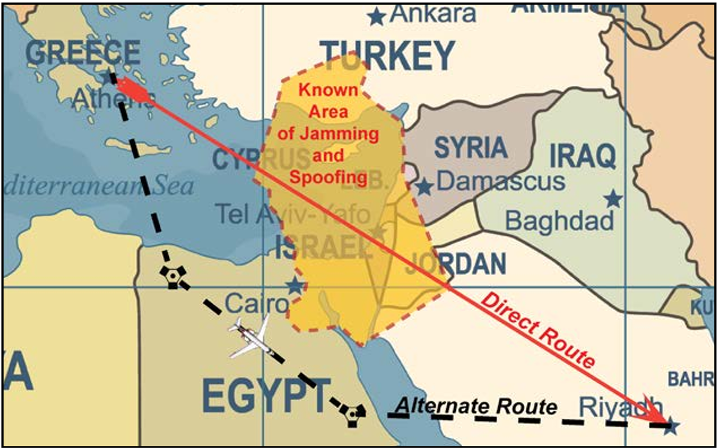
The U.S. Federal Aviation Administration (FAA) has updated its “GNSS Interference Resource Guide.” The FAA’s Flight Technologies and Procedures Division (AFS-400) developed the guide to provide operators and pilots with current information on GPS/GNSS jamming and spoofing. According to the guide, “As the threat of GNSS jamming and spoofing is constantly changing, the FAA will update this resource guide to provide the best guidance in the rapidly changing environments.”
UK scientists unite to uncover coastline mysteries
The research vessel Cefas Endeavour at dock in Lowestoft.(Credit: Cefas)
The UK Centre for Seabed Mapping (UK CSM) conducted a survey to explore and map the seabed along the United Kingdom’s southwest coastline. For four weeks, a team of 26 maritime scientists collected hydrographic, geological and environmental data. According to UK CSM, the survey represents an unprecedented level of collaboration within the maritime sector. The team aimed to collect and share high-quality marine data and make advances in how the seabed is mapped, understood and managed. The findings will support a wide range of applications including offshore energy and infrastructure, marine ecosystem science, safety at sea, marine policy, and defense.
Bangladesh at the top
Credit: MD Maruf Hassan/E+/Getty Images
In April, field teams for the Survey department under the Ministry of Defense conducted field work in the remote hill areas of Bangladesh to determine the highest peak. Surveyors used modern geodetic methods and advanced GNSS technology in the Bandarban district, and followed international standards to determine the height of the country’s highest peak above mean sea level (MSL) with centimeter-level accuracy, including latitude, longitude and elevation.
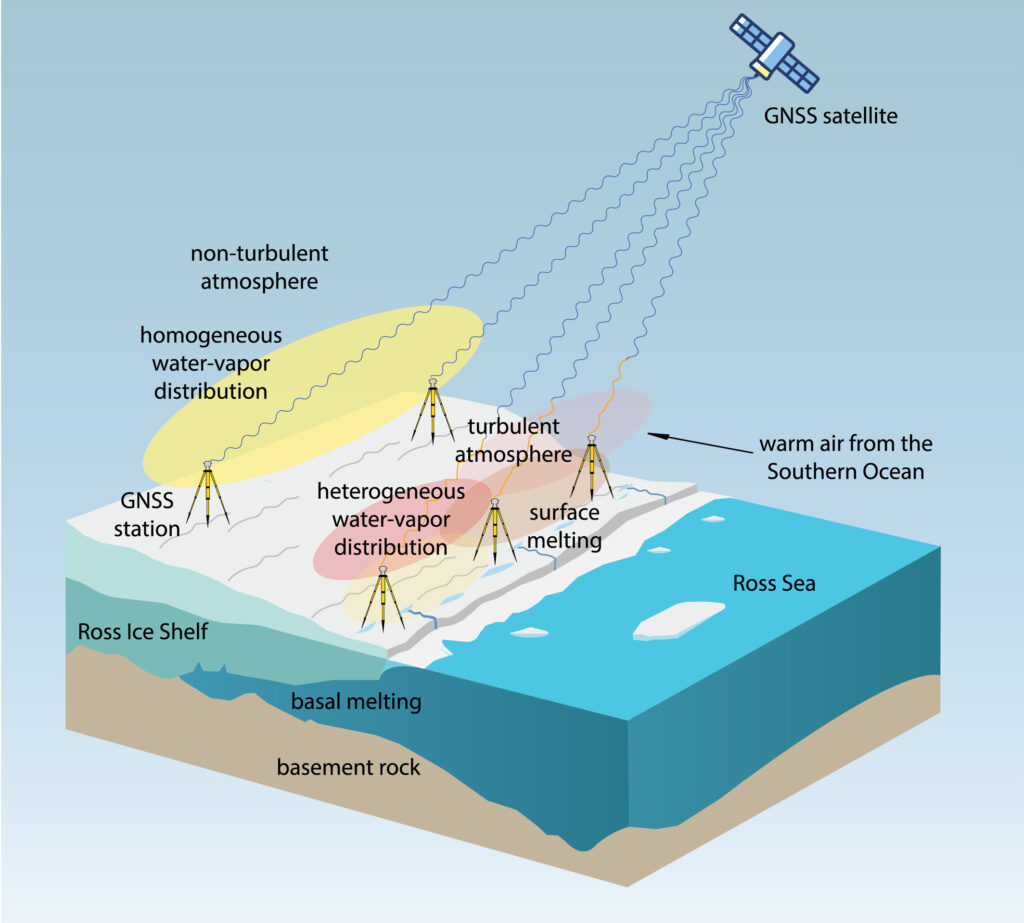
Turbulence shrinks Antartica’s Ross Ice Shelf
Sketch (not to scale) of GNSS sensitivity to atmospheric turbulence in Antarctica (Credit: MIT)
GNSS observations suggest a major melting event at Antarctica’s Ross Ice Shelf was linked to atmospheric turbulence. While the shelf typically melts underneath from warm ocean water, an unusual surface melting episode occurred in January 2016. Researchers from MIT Haystack Observatory used data from existing GNSS stations, with 13 stations installed on the shelf, to examine atmospheric turbulence. Wind, water vapor and temperature variations drawn in by warm and humid air caused the surface to melt, with turbulence four times greater than usual.
The U.S. commercial drone industry is at an inflection point. After years of incremental progress, the FAA’s landmark Part 108 Beyond Visual Line of Sight (BVLOS) rule is expected to take effect later this year, unlocking a new era of scaled commercial drone operations across delivery, infrastructure inspection, public safety, perimeter protection and beyond. It’s a pivotal moment for drone operators to get ahead of the most significant regulatory shift the commercial drone industry has seen.
Today, AirData UAV announced it is joining the Commercial Drone Alliance (CDA), bringing its operational platform into the industry’s broadest coalition for drone policy and progress. As a member of the CDA, AirData will actively contribute to the policies and standards that will define the next chapter of the U.S. drone economy through the CDA.
Part 108 introduces sweeping new operational requirements across pre-, during and post-flight documentation, personnel roles, risk-categorized operational areas, and mandatory continuous data reporting, and AirData’s platform is already built to meet them.
“We are at a critical moment for the drone economy,” said Lisa Ellman, Chief Executive Officer of the Commercial Drone Alliance. “As the industry moves toward broader BVLOS operations and frameworks like Part 108, access to scalable, reliable operational data such as that which AirData provides will help to safely unlock the full potential of the drone economy.”
Credit: AirData UAV
AirData’s platform delivers the tools operators will need to meet Part 108’s requirements, including: checklists, automated compliance documentation, flight logging across every mission, and fleet-wide analytics that give program managers visibility into operational risk. With more than 61 million flights across 450,000 pilots and 850,000 drones globally, AirData has been building the compliance infrastructure the industry now needs.
As the industry’s leading policy advocate, the CDA has been central to advancing the regulatory frameworks. The CDA is an independent non-profit organization led by key members of the commercialdrone industry. It works to educate policymakers and the public on the safe integration of drones into the national airspace and to advocate for policies that enable commercial drone operations.
“We have long served as the intelligence backbone for drone operations,” Eran Steiner, CEO and founder of AirData UAV. “We look forward to leveraging our data, insights, and experience to enable scalable, compliant, and mission-critical drone programs, particularly as frameworks like Part 108 unlock the next phase of scaled BVLOS operations in the United States.”
AirData’s platform gives public safety agencies, enterprise operators, and drone programs of every size the maintenance documentation, pilot currency tracking, asset management, checklist discipline, and operational data history that regulators will expect when Part 108 takes effect.
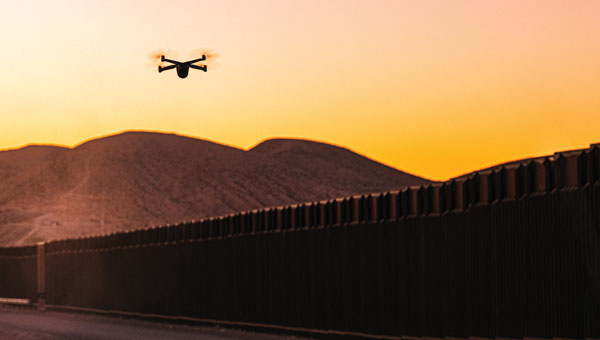
The U.S. Federal Aviation Administration (FAA) has issued a proposed rule that would allow specific categories of critical infrastructure sites to apply for restrictions on drone operations around their facilities.
The restrictions would be submitted and approved via a new FAA web portal. Approval will be based on safety or security criteria. Sixteen sectors would be eligible for restrictions including energy production, transportation systems, chemical facilities, water treatment plants, and defense industrial complexes.
The rule would establish two types of restrictions:
Standard Unmanned Aircraft Flight Restriction (UAFR): A general restriction that bars unmanned aircraft operations within a specific boundary, except for operators who have previously met rigorous safety and security standards.
Special Unmanned Aircraft Flight Restriction (UAF): A much more severe restriction that bars unmanned aircraft operations within a specific boundary for all operators unless they have the express prior approval from both the FAA and the sponsoring agency (for example, the Department of Homeland Security).
The restricted area would have clearly defined horizontal and vertical boundaries. Violators could face civil or criminal penalties.
The rule would also allow site operator to contact law enforcement if a drone flew in a restricted area, after which authorities can use Remote ID to locate the control station or operator. Pilots could face license suspensions, revocations, fines and criminal charges for entering these no fly zones.
Drone operators are encouraged to check B4UFLY for the latest breakdown on where pilots can and cannot fly.
Additional Information:
Restriction criteria includes impacts to aviation safety, protecting people and property on the ground, national security, or homeland security.
The full list of eligible site categories are:
Chemical
Commercial
Communications
Critical manufacturing
Dams
Defense industrial base
Emergency services
Energy
Financial services
Food and agriculture
Government services and facilities
Healthcare and public health
Information technology
Nuclear reactors, materials, and waste
Transportation systems
Water and wastewater
The comment period on the proposed rule will run until July 5, 2026.
The U.S. Federal Aviation Administration (FAA) has updated its GNSS Interference Resource Guide with updated information on GNSS vulnerabilities and general edits throughout.
The FAA’s Flight Technologies and Procedures Division (AFS-400) developed the guide to provide U.S. operators and pilots with the most current information regarding GPS and GNSS jamming and spoofing.
According to the guide’s introduction, “The impacts of safety hazards from GNSS interference rapidly spread over the past few years and is persistent. As the threat of GNSS jamming and spoofing is constantly changing, the FAA will update this resource guide to provide the best guidance in the rapidly changing environments.”
The U.S. Federal Aviation Administration (FAA) has warned all pilots to “exercise caution” when flying in the airspace over Venezuela “due to the worsening security situation and heightened military activity,” reports ABC News. Possible risks include GNSS jamming and spoofing.
The FAA message said the unspecified threats “could pose a potential risk to aircraft at all altitudes” as well planes taking off and landing in the country and even aircraft on the ground.
The warning comes as the Trump administration has ramped up pressure on Venezuelan President Nicolás Maduro. The Trump administration also has carried out a series of strikes on small boats in the Caribbean Sea and eastern Pacific Ocean that it accuses of ferrying drugs to the U.S., killing more than 80 people since the campaign began in early September.
The Ford aircraft carrier and several destroyers were just the latest addition to the largest U.S. force assembled in the Caribbean Sea near Venezuela in generations. The Trump administration does not see Maduro, who faces charges of narcoterrorism in the U.S., as the legitimate leader of the South American country.
To echo the Association for Uncrewed Vehicle Systems International’s (AUVSI) pleas to Congress, a prolonged government shutdown could impact recent efforts to establish stronger counter-UAS protection for sensitive establishments across the U.S. and forestall key Federal Aviation Administration (FAA) hiring plans to support safe drone integration into the U.S. National Airspace System.
Nothing is good about having roughly 750,000 people out of work and stalling their buying contributions to the American economy, not to mention that air traffic controllers, Border Patrol agents and other essential services are still working without pay. Hopefully common sense will prevail and the government will reopen soon.
Originally known as the Boeing Airpower Teaming System or “Loyal Wingman,” the Boeing Australia MQ-28A Collaborative Combat Aircraft has been rechristened. Developed jointly by Boeing and the Royal Australian Air Force, the MQ-28A was not entered in the U.S. CCA competition and has remained fully employed in Australia with its team. Now referred to as the “Ghost Bat” — a name inspired by a north Australian flying bat by the same name, which uses “multi-spectral sensors” to hunt and learn in packs together — the name is a fitting analogy for the anticipated role of the MQ-28A.
Ghost Bat taxies at RAAF base Woomera in Australia. (Credit: Beoing)
Flying since February 2021, the Ghost Bat has made significant steps toward operational readiness. Using AI-powered intelligence to perform autonomously, Ghost Bat has a replaceable nose section, each fitted with different sensor suites appropriate for different missions.
With eight vehicles now available for a comprehensive operational verification test, in June and four months ahead of schedule, Ghost Bat completed a series of flights at both Woomera and Tindal bases in northern Australia. Capabilities demonstrated included autonomous missions, multi-ship operations and teaming with an E-7A Wedgetail early warning aircraft — including data fusion between multiple MQ-28A Ghost Bat aircraft and the crewed Wedgetail. The aircraft has flown for 150 hours and has accomplished more than 20,000 hours of virtual and ground testing. Able to find, fix, track and target, MQ-28A has proven its capability to carry out essential pieces of the air combat role — remaining elements include engage and assess, which will involve carrying air-to-air missiles later in 2025.
This apparently brings the Boeing MQ-28A close to operational capability and ready for volume manufacturing. The eight aircraft have been built at an automated manufacturing facility in Melbourne, where two improved versions are currently being built that incorporate improvements developed through the testing phase, and a combined GPS/INS system will replace the commercial GPS on the aircraft. Ground has meanwhile been broken on a 100,000-square-foot high-volume manufacturing plant in the Wellcamp Aerospace and Defence Precinct in Queensland — expected to be complete within three years.
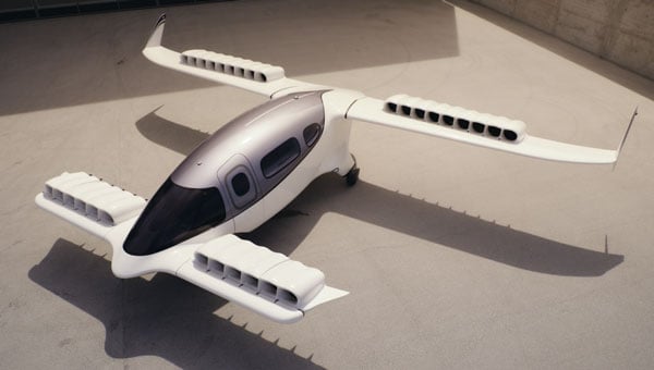
While electric vertical take-off and landing (eVTOL) air-taxis under development progress towards certification by FAA and other agencies, introductory trials are also underway and agreements for future collaboration are being made all over around the world. While major players such as airlines and manufacturers have invested heavily to provide the capital for eVTOL development and manufacturing, one such agreement appears to be in trouble.
Lilium jet eVTOL (Credit: Lilium)
Lilium, a jet eVTOL developer, and GlobeAir, an existing operator of an Austrian fixed-wing business aviation operation, signed a memorandum of understanding in September 2022. GlobeAir posted an article on its website that said it saw the agreement with Lilium as a step toward the “next generation of regional air mobility” and that it intended to buy 12 jet-powered Lilium eVTOL aircraft “to operate in Northern Italy and the French Riviera.” GlobeAir was also reported to have supported the inclusion of several potential key local suppliers to participate in the build of Lilium aircraft.
Lilium went bankrupt in October 2024, and its assets and intellectual property have been up for bids. Emerging briefly from bankruptcy protection, Lilium again ended up broke and on the auction block in February 2025. Vaeridion has already purchased Lilium’s battery facility, and Ambitious Air Mobility is close to a deal to acquire the rest.
The CEO of GlobeAir has now told the magazine Aviation Week in an interview that he expects the whole eVTOL adventure to fail, given the cost of not only vehicle development and construction but also the landing and charging infrastructure needed. Other hurdles include the level of test and verification and excessive levels of documentation — overall being “highly regulated, with low margins.” It’s an unfortunate, perhaps premature assessment from an existing fixed-wing operator who contracts out last-mile passenger transitions to third-party helicopter operators.
So, there is another mixed bag of going ons in the world of unmanned and derivative eVTOL aircraft – hopefully following the restoration of funding for the government, paused programs will be restored to extend counter UAS defenses across the U.S., Ghost Bat will complete its combat engage and assess phases and there will be much better news on the eVTOL front.
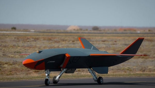
General Atomics Aeronautical Systems Inc. (GA-ASI) is in the news again, as it got its prototype version of the U.S. Air Force (USAF) Collaborative Combat Aircraft (CCA) into the air for the first time, with an anticipated lengthy flight test campaign to follow. This latest CCA iteration, refered to as the YFQ-42A CCA, was derived from an earlier jet-powered XQ-67A Off-Board Sensing Station, a platform that enabled the company to not only develop and build but also fly this latest aircraft in just one year.
GA-ASI CAA makes first flight Aug. 27, 2025. (Credit: GA-ASI)
The UAV features significant autonomous capabilities developed over nearly five years of training using the MQ-20 Avenger unmanned jet aircraft. The strategy of beginning with a company-developed baseline aircraft (Avenger), securing USAF support for an initial derivative and then for the YFQ-42A CCA, appears to be accelerating development of the Loyal Wingman concept toward USAF operational manned-unmanned airborne teaming.
Previously, in July, GA-ASI began preparations to enable friendly European countries to rapidly participate in the future CCA-capabilites by teaming with its German affiliate General Atomics Aerotec Systems GmbH (GA-ATS). The agreement appears to enable high-volume local manufacture of a European CCA, and press releases have implied that potential content is expected to be provided by other high-tech local suppliers.
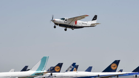
Following earlier reports that Reliable Robotics (RR) has been busy automating all phases of aircraft operations, including a Cessna Caravan cargo aircraft, USAF has awarded RR a $17.4 million contract to install a Reliable Autonomy System (RAS) in another Cessna. The resulting automated Cessna 208A Caravan is to be used in an estimated two-year program toward obtaining FAA certification that should enable flight within the U.S. National Airspace System (NAS). The system has been demonstrated — with a remote pilot in the loop — to be able to take an aircraft from startup on the ramp, through taxi, takeoff, en route flight, landing and taxi return to the ramp for unloading.
RR autonomous Cessna 208B takes off from Mojave Air and Space Port, California, on Aug. 8, 2024. (Credit: RR)
Cessna Caravans have been heavily used for cargo transport across the U.S. (and around the world) with a range of 1000 miles, carrying up to 1000 lb of cargo. The RR certification program is intended to allow these types of automated unmanned commercial and military operations on a regular basis throughout FAA controlled US airspace, alongside manned aircraft. Flying military unmanned aircraft in the NAS currently requires extremely highly-coordinated, continuous activity. The hope is that eventually it could become an easier more regular form of autonomous cargo/people air transport.
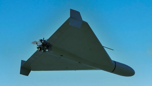
The cost of the continuing war in Ukraine may be affecting the Russian economy — a major drone manufacturer apparently is facing bankruptcy despite Russia currently using thousands of drones in attacks on Ukraine. The situation is difficult to understand, but this is an expensive war.
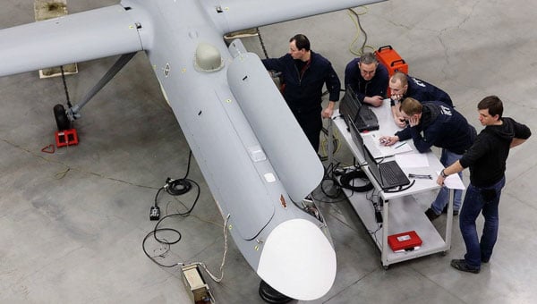
However it appears that, AO Kronshtadt, one of the major drone suppliers in Russia is also beset by civil lawsuits from several organizations to which it owes lots of rubles. Its Orion and an updated version Inokhodets drone are apparently somewhat similar to the US MQ-9 Reaper UAV.
AO Kronstadt employees assemble the Russian Orion UAV. (Credit: open source)
Russia has apparently converted the Orion/Inkhodets medium-altitude surveillance drone into a strike version, but with limited success. Nevertheless, Kronshtadt apparently has made some progress, selling an export version in Asia.
Meanwhile, Russia still is apparently producing up to 6,000 Shahed one-way drones per month by another manufacturer in the Alabuga Special Economic Zone at a unit cost of around $70,000. This is significantly lower than drones that were originally purchased from Iran at $370,000 each.
The U.S. Federal Government through its transport agencies apparently has the exclusive right to control drones, including bringing malicious UAVs down from the sky. Most people understand that the Federal Aviation Administration (FAA) regulates who flies what and where, but who is in charge of reducing and removing drone threats? It may have been difficult to understand during recent unauthorized overflights of military installations on the East Coast why someone didn’t shoot down the offending drones.
Now, a group of police agencies has approached members of Congress to ask for the right to “detect, track, identify and mitigate” the unlawful, negligent or malicious use of drones that threaten public safety. Citing a number of incidents — including drone incursions at airports and other incidents where unmanned aircraft have interfered with firefighting and disaster response, instances where law enforcement activities have been overflown and disrupted, and the practice of using drones to drop drugs, guns and mobile phones into prisons — the law enforcement group sees a need for permission to engage. With several major events scheduled across the U.S., it likely is time to support law enforcement with the appropriate powers needed to protect the public.
It is true that several bills are already pending before Congress to enable state, local, tribal and territorial law enforcement agencies to find, identify and possibly mitigate inappropriate drone activity, but the group is urging action now. And they clearly demonstrate the need to be able to stop drone activity when necessary — the federal government cannot cover the whole country all the time, so it makes more sense to adequately train law enforcement and to distribute authorized local mitigation activity whenever it is found to be necessary.
So a mixed bag this month — progress for the U.S. Collaborative Combat Aircraft initiative, more steps toward automation for air cargo transport, problems for one Russian drone supplier while others increase volume and the United States seeks options for better defense against them, and U.S. law enforcement seeks the capability to help mitigate drone incursions where they are not wanted — plenty of different angles to consider around unmanned aerial vehicles.
FAA regulations require drone enthusiasts and commercial operators to equip their unmanned aircraft with approved remote identification (RID) capability. Following the FAA’s deadline on March 24, 2024, each registered drone in U.S. airspace is required to transmit its location, operator information, altitude, velocity and registration code. This data can be utilized to identify the drone’s operator. Additionally, most drones will need to include a timestamp for data synchronization and an emergency status indicator if necessary.
As a concession to purely recreational drone flyers, the FAA allows local organizations to designate and register an area as a reserved location for drone flying — an FAA-recognized Identification Area (FRIA) — and drones flown only in such locations are exempt from the RID regulation. As of September 2023, manufacturers are required to only sell drones with RID capability, and owners of older drones can purchase RID devices to add to their equipment. Some come with an internal GPS, but others connect to existing onboard GNSS receivers.
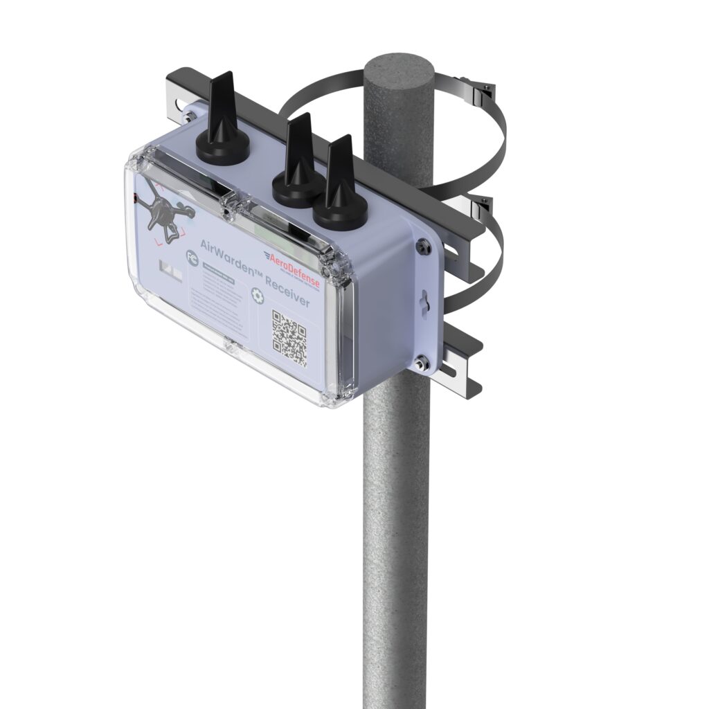
Given this RID-equipped population of drones, AeroDefense in Oceanport, New Jersey, has come up with an inexpensive way of locating legal drones and providing tracking information by providing an area monitoring system. Drone incursions into controlled airspace are not all malicious in nature— in fact, most have turned out to be accidental. So, a low-cost capability, such as the AirWarden Essential system, can be helpful to many facilities wishing to know what drones are in their airspace.
An AirWarden receiver mounted on a pole with a clear view of the sky above the monitored area can capture broadcast transmissions from drones flying overhead. the information is transmitted to a display system that highlights RID-equipped drones in the monitored area, showing not only the altitude and direction of the drones but also the operator’s identity and the location from which the drone was launched. The data can be downloaded to the internet, so facility personnel can also receive incursion warnings remotely, if they happen to be away from the facility. Otherwise, the system provides real-time alerts to your chosen display, along with a tracking history and the location of the launch point.
AeroDefense identifies several key locations for this system, including correctional facilities, venues such as stadiums and large outdoor gathering spots, airports, military bases, critical infrastructure such as power and water distribution centers, and industrial complexes.
What about non-RID drones, which can spy on technology, gather sensitive information, conduct reconnaissance of military facilities, smuggle contraband into correctional facilities, or even damage infrastructure? These drones can operate outside the law and evade FAA regulations. AirWarden indeed offers extensions that facilitate RF detection of both drone control and data transmissions, along with tracking the direction of drone movement. Combined with radar, the system becomes a robust detection solution for both RID and non-RID drones.
Mayman Aerospace in Long Beach, California, has developed a jet-powered vertical take-off and landing (VTOL) cargo drone. It needs only 10’ x 10’ to take off and land, and in flight, it is claimed to be able to reach 500mph (Mach 0.75) and operate at 20,000 ft.
Razor VTOL drone with vectoring jet-powered thrust. (Photo: Mayman)
The Razor VTOL features gimballed, jet-powered thrust for takeoff and landing and a high-speed sprint speed for fast deliveries on the battlefield. The initial application might be for the Department of Defense, but Mayman anticipates that other commercial applications already exist for rapid 50-lb cargo transit.
And Mayman describes other capabilities as including artificial GPS-denied navigation and autonomous control for reliability and accuracy in areas where signal jamming is present. The aircraft has an automatic abort/land capability in the event of catastrophic failure.
This new intelligent vehicle appears capable of various applications, including fast cargo transit, Intelligence, Surveillance, Target Acquisition and Reconnaissance (ISTAR), disaster recovery, serving as a low-cost maneuverable airborne target for pilot training and even functioning as an attack drone.
While recent sky-filled drone incursions have been highly reported and publicized, another means to help detect and locate their operators cannot come at a better time. The AirWarden system appears to have a lot of promise, notwithstanding that radar, RF and acoustic detection systems may also be required for “illegal” drones. Thrust-vectoring, cargo carrying and autonomy in a drone are not just a novel combination, these capabilities do appear to have a great deal of promise for both military and commercial operations.
The Federal Aviation Administration (FAA) has partnered with the Naval Air Warfare Center Aircraft Division (NAWCAD) to initiate steps toward approving Controlled Reception Pattern Antennas (CPRAs) for use in aircraft. This collaboration addresses GPS/GNSS jamming and spoofing threats, with the current focus on a Request for Information (RFI) to study anti-jamming and anti-spoofing technologies. The RFI, published on SAM.gov, aims to identify and evaluate vendors’ antenna technologies for potential integration into civilian aircraft.
CPRAs could significantly mitigate terrestrial-based GPS/GNSS jamming and spoofing, enhancing aviation safety by preserving situational awareness and reducing pilot workload during disruptions. The technology’s effectiveness in neutralizing ground-based threats positions it as a critical tool for maintaining reliable navigation systems.
RFI details and next steps
NAWCAD is leading the RFI process, which includes hosting industry days and establishing Cooperative Research and Development Agreements for testing hardware and evaluating performance. Responses to the RFI are due by May 26, 2025, at 5:00 PM EST, with questions accepted until April 25, 2025. Data from the RFI and subsequent testing will inform updated Minimum Operational Performance Standards for GPS/GNSS antennas and cockpit displays.
Dana Goward, president of the Resilient Navigation and Timing Foundation, noted that this is a great first step, but cautioned that widespread adoption of CPRAs in commercial aircraft will take a long time due to the lengthy FAA approval and certification processes, along with the significant financial investment and effort required to install CRPAs in airplanes.
Although CPRAs address terrestrial threats, space jamming continues to be a critical concern. Adversaries often outpace countermeasures, necessitating continuous innovation to keep up with advancing threats.
FAA safety alert highlights risks
The FAA issued Safety Alert for Operations (SAFO) 24002 on Jan. 1, 2024, to alert operators and manufacturers about the risks of GPS/GNSS disruptions. The alert emphasized the potential for increased pilot workload and safety risks due to situational awareness loss during jamming or spoofing incidents.
On Jan. 17, 2025, the State Department proposed removing CPRAs from the U.S. Munitions List (USML), shifting their regulation to the Commerce Department’s Export Administration Regulations (EAR). This change, effective Sept. 15, 2025, aligns CRPA export controls with other dual-use technologies, streamlining their adoption. A 60-day public comment period is open via regulations.gov.
It cannot be denied that people are seeing more objects flying in the night sky. It is suspected that these are unauthorized UAVs collecting information over U.S. and international military bases and, well, also over people looking up at the sky in their backyards at night. It is unlikely that these unidentified flying objects are causing much harm to the civilian population other than being a curiosity. However, it remains unclear what they might be doing over military installations.
In November and December 2024, numerous reports emerged of UAVs surveilling residential neighborhoods, restricted zones and critical infrastructure across the Northeast United States. This includes areas such as water storage facilities, transmission lines, railway installations, police departments — both local and federal — and military bases.
Military bases reporting UAV overflights included Wright-Patterson Air Force Base in Ohio, Picatinny Arsenal and Naval Weapons Station in New Jersey and Ramstein Air Base in Germany. In the UK, Royal Air Force (RAF) bases at Lakenheath, Mildenhall, Feltwell and Fairford in the South of England all reported unauthorized UAV overflight activity, which is somewhat concerning for nuclear weapons bases in Europe. Lakenheath appears to have scrambled F-15s to investigate one such UAV incursion.
Detecting and mitigating threats
In the United States, the increased intensity of UAV sightings has residents and Congress concerned, while various authorities claim that most of these incidents are harmless. A joint statement by the Department of Homeland Security, the Federal Bureau of Investigation, the Federal Aviation Authority (FAA) and the Department of Defense stated:
“Having closely examined the technical data and tips from concerned citizens, we assess that the sightings to date include a combination of lawful commercial drones, hobbyist drones, and law enforcement drones, as well as manned fixed-wing aircraft, helicopters, and stars mistakenly reported as drones. We have not identified anything anomalous and do not assess the activity to date to present a national security or public safety risk over the civilian airspace in New Jersey or other states in the Northeast.”
Nevertheless, these agencies reported, “Local commanders are actively engaged to ensure there are appropriate detection and mitigation measures in place.”
No other major announcements have followed these incidents, but it would seem logical that military bases have begun activating existing detection and defensive systems. Known countermeasures may include specialized radar, laser, optical, acoustic and radio frequency (RF) detection and defensive systems.
Radar always has been employed to detect airborne intruders, and the reflections from them appear on a display, which the ground user can then align with a range of potential defenses. However, UAVs are generally small, while conventional radar is designed to pick up hefty reflections from the surface of full-size commercial and military aircraft.
Photo: Robin Radar Systems
Robin Radar Systems
Robin Radar Systems in Holland has worked to refine radar that can detect small flying objects. Birds can cause havoc at airfields where aircraft take off and land at high rates, so detecting birds for airfield operators is one angle for which Robin Radar Systems has developed a reflection capability. A large bird and a UAV might be very similar in size. To differentiate the two, the company found a way to see a Doppler effect (speed differences) within a radar return, which indicates the spinning rotors of a UAV rather than flapping wings — a system they term micro-Doppler radar. This detection system works to find objects many miles away and at well-defined approach angles from the radar antenna. Therefore, these X-Band radars are mostly based at the places you want to protect, such as airfields. Some radars also can be packaged to be transportable, perhaps for military applications, where a temporary base needs to know if enemy attack UAVs might be on their way.
Other principal detection systems include “sniffing” RF frequencies to detect UAV control signals, but this has a shorter range than radar and does not easily determine distance or approach angle without several triangulating bases. Additionally, of course, UAVs without control signals cannot be detected with this particular RF technology. Optical systems using still/video/infrared (IR) cameras are good in daylight, but not so good in the dark. Acoustic systems use microphones or an array of microphones to listen for rotor sounds but have a shorter range (less than 1/3 of a mile).
Then, if you have suitable defensive capabilities, you could either take down an unwanted UAV by flying a counter-UAV to collide with and destroy it or by trapping it in a net. In a military situation, many UAVs have been shot down by various types and calibers of guns — and even by very expensive missiles. Electronic defenses include jamming guidance and/or control signals by transmitting signals that overcome and scramble the GNSS and/or control signal or by frying its electronics using high-power microwave transmissions or high-powered laser(s) — these last two systems are expensive and heavy, which makes them cumbersome.
Spoofing the on-board GNSS receiver by transmitting false satellite signals to steer the UAV away from its target recently has been used by Ukrainian forces to steer attack UAVs back into neighboring countries.
GNSS jamming is widely used, and there are numerous equipment suppliers; however, spoofing systems are less common due to their additional complexity and cost. Some RF systems can collect data from the opposing UAV and even detect where the operator might be located.
Of course, not all UAVs straying into restricted airspace come from operators with bad intentions — some might be “Sunday-driver” recreational UAV flyers who have allowed their UAVs to stray into the wrong area. This is another reason the FAA requires formal UAV operator training and certification for commercial operations, but this is not required for recreational UAV flyers.
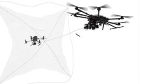
DroneHunter drone net capture system. (Photo: Fortem Technologies)
FAA regulations
The FAA regulations for UAVs are fairly easy to understand, and it would probably take an intentional effort to fly unauthorized into restricted airspace. Otherwise, stay at or below 400 ft, don’t exceed 100 mph, don’t go where you shouldn’t, file a flight plan — ask permission using the automated FAA LAANC online tool — but always stay within visual range of the UAV. Those are most of the basics. Additionally, to operate a UAV commercially, you must also register it with the FAA and install an electronic device to tell everyone in the surrounding airspace the drone’s registration number, which is traceable to the owner/operator. Never fly near clouds, comply with local rules when flying recreationally, and never, ever fly into restricted airspace, particularly around airports, without prior authorization.
These multiple reported UAV incursions violate FAA regulations, so it is reasonable to assume the operators are deliberately flying illegally. Recreational flying requires the operator to see the UAV at all times — so flying at night is not legal either, as the rules state not to fly an hour after sunset or an hour before sunrise. Operators in restricted airspace are committing a crime punishable by fines and/or years in prison. Yet they still fly, so are they nuisance operators who don’t care or is the activity criminally motivated or orchestrated offshore?
Utilizing UTM
Would the coming unmanned aircraft system traffic management (UTM) have been able to keep these intruders away? I am not sure, but UTM is designed to manage UAV traffic, so presumably, it could manage these UAVs to comply with traffic requirements. However, these intruders are already ignoring existing laws, so UTM may more readily enable the identification of rogue UAVs and operators. Recent tests at the FAA/NASA UTM test range in North Texas have drawn huge interest from Walmart and Amazon, as they push to get UAV package delivery working. Wing now delivers for Walmart using a production UTM system in Dallas and Fort Worth, Texas.
To wrap this up, amongst many recently reported unidentified flying objects, several have been identified as probable UAVs, and some of those over restricted areas could be detected and managed with existing technologies. FAA regulations ban flights in restricted airspace unless approved — i.e., working in coordination with those ground facilities. There are UTMs for UAVs already being used commercially, which could assist in managing all UAVs.
Unmanned Traffic Management (UTM) is an air traffic management system for UAVs and other unmanned air taxis or similar aircraft. In the United States, this is in airspace below 400 ft, avoiding other airborne traffic — including other UAVs — and informing authorities of your intended flight plan and how you execute it versus the posted plan.
Where are we on getting such a system? Well, there is an entire directory of nearly 80 UTM suppliers, mostly commercial outfits that offer UAV traffic control of some description for some application – typically like surveying a limited area for construction or maybe a related military application. Few companies possess “full function” UTM capabilities, along with extensive expertise and experience. Each commercial flight needs the approval of the FAA, so software packages include an FAA application to fly and feedback of authorization for the flight plan, as well as approval of operator certification and UAV type. There are complex packages from third-party sources, including NASA-developed UTM, as well as independent commercial systems.
So, how would that work across a major geographical area, such as the entire United States? The FAA and NASA have been working to establish how it could work, at least at a test site in Dallas, Texas.
First, the industry participants in this trial who wanted to operate in the same area had to accede to cooperate. Agreements were signed and means were established for data to flow between the participants, their drones and the FAA (the North Texas Shared Airspace Implementation). The limits of the area near Dallas/Fort Worth for the trial were established as the boundaries in which the parties would fly and, in this case, complete deliveries. The players are Walmart, Amazon, Wing, Manna and ANRA, with FAA and NASA watching carefully.
One of the principal actors in Air Traffic Management (ATM) is ANRA in Washington D.C., with offices in London, UK, and New Delhi, India. With more than 100 customers in 15 countries and more than 200 projects, their UTM/ATM systems are gaining wider experience in several different airspaces and differing traffic compositions. The system is evolving with wider applications as installations worldwide meet new requirements. AAM for eVTOL passenger-carrying aircraft provides mission planning, traffic deconfliction, vehicle tracking, constraints management, route authorization and vehicle registration. EVTOL aircraft will likely fly not only in and out of existing airports but also from new Vertiports specially built for short-hop eVTOL flights across cities. ANRA has already engineered a Vertiport Management System (VMS) to control unmanned and autonomous access to airports and Vertiports alike.
Another unrelated development in the world of UAVs is the phenomenon of high-altitude platform station (HAPS) UAVs and their ground infrastructure. Although flying at altitudes on the edge of space, it is likely special provisions would be required within its associated UTM system to keep track and warn other high-altitude flyers. Nevertheless, the highest-flying commercial aircraft would probably be at an altitude nearly 30,000 ft below HAPS remote Stratospheric perch.
Airbus Zephyr HAPS. (Photo: Aalto)
Airbus company Aalto Haps, based in Farnborough, UK, is now responsible for the manufacture, operation and commercialization of the Airbus Zephyr HAPS vehicle line. Designed to fly for months at a time, with wings covered in solar cells for power, Zephyr has established a world record of 64 days on station in the Stratosphere, and aalot has a target to fly for 200 days regularly.
So, what do you do with such a high-altitude, long-persistence platform? Well, it is like having your own satellite, which you can hang payloads on for tasks such as surveillance, disaster assessment and relief, border control, and numerous precision GNSS applications. With an apparent footprint of close to 3,000 square miles and an appropriate communications relay capability, you have a cell-phone tower in the sky. Perhaps even a partial equivalent to the Space-X Starlink space-based satellite communication service for provision of voice and internet, but seemingly far less infrastructure than the conventional 250 ground cell-towers needed for such an area.
Places starved of phone and internet service — such as Africa — could greatly benefit from flying their kite and gaining wide area coverage. To demonstrate how this capability would work, Aalto recently established a presence in Laikipia, Kenya, building an AALTOPORT ground facility and working with the Kenyan civil aviation authority to qualify Zephyr and its communications role for operations in Kenyan airspace. It is, of course, opportune that Kenya’s location on the equator provides access to one of the most sunny days available to power Zephyr at altitude. Laikipia County is also on a raised plateau, providing Zephyr with an altitude advantage for initial launch. Incidentally, Aalto flew Zephyr for 13 days over Kenya to prove the point.
With the facility in the UK able to build Zephyr-like UAVs every three months or so, Aalto aims to establish a number of hubs (such as the one in Kenya) around the world and operate a number of HAPS aircraft continuously, providing communications and all sorts of services commercially.
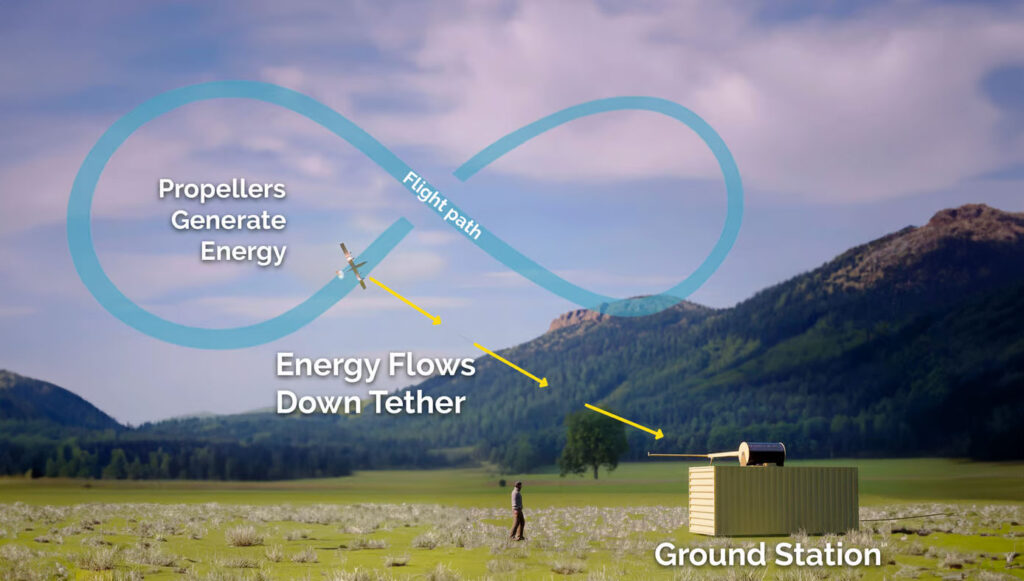
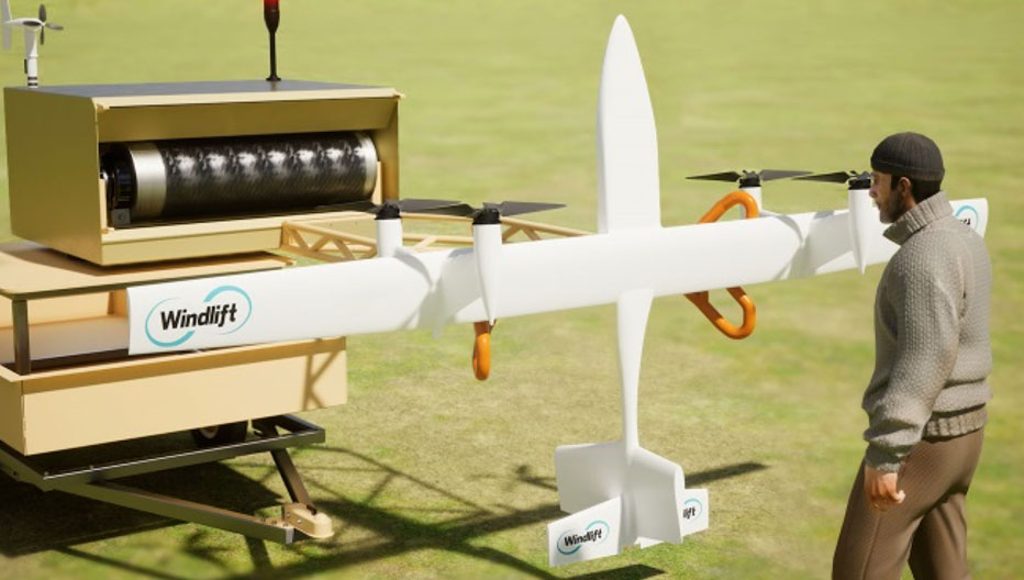
A new startup is investigating the concept of putting a tethered drone in the air with specially designed propellers driven by electric motors. This combination then turns into electricity generators for a particular flight pattern.
Windlift power generation cycle. (Photo Windlift)Transportable power generation. (Photo Windlift)
Initially focused on propeller design, Windlift was established in 2006 and is still based in Durham, North Carolina. Its approach is to use UAVs as a power source — flying repeatedly in a figure of eight, potential energy is converted to electricity in several non-powered phases of flight. The specially designed rotors turn to capture energy in those phases and their prop motors become generators of electric current, which is passed to the ground through the tether wire, to be ultimately supplied to the grid.
However, this setup could be portable, making it suitable for a small military or research team in the field needing power. This portability could be related to a $30 million contract Windlift has received from the U.S. Naval Research Laboratory, which is interested in technologies that the Navy and Marine Corp could use. Under the contract, the building and testing of a working prototype and demonstration to the Department of Defense is required. According to Windlift, this is a successful result of several earlier, smaller Small Business Innovation Research contracts to helped develop the necessary technological elements of today’s system.
Commercially, the UAV power generation approach appears to be extremely cost-effective versus the costs associated with today’s wind farms of huge wind turbines. Not only is the construction cost of each tower, its generator, and the huge blades very high, but the wear and tear of operations over time require expensive maintenance. Meanwhile, the UAV, while still in its infancy with lots of reliability and weatherproofing to be accomplished, has the potential to reduce power generation costs by up to 80%, Windlift said.
This month’s UAS news indicates how UTM is well along the path towards managing UAV integration into the National Airspace System, HAPS high-altitude aircraft may be back in the news as Aalto moves forward with commercialization plans, and yet another application for UAVs appears to involve a new potential approach for power generation. A pretty wide range of unmanned requirements and applications.
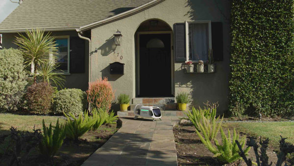
The Federal Aviation Administration (FAA) has authorized commercial UAV flights without visual observers in the Dallas-Fort Worth area, marking a significant milestone in U.S. aviation. This authorization has been granted to Zipline International and Wing Aviation, enabling them to conduct package delivery operations using UAVs while sharing airspace with conventional aircraft.
The UAVs remain separated from manned aircraft using unmanned aircraft system traffic management (UTM) technology, with rigorous FAA safety oversight. UTM services allow companies to share data and planned flight routes with other authorized airspace users, offering safe organization and management of UAV flights in shared airspace. All flights occur below 400 ft altitude and away from any crewed aircraft. The FAA expects initial flights using UTM services to begin in August 2024.
Typically, UAV operators must maintain visual line of sight with their aircraft. However, advancements in air traffic technology are paving the way for routine beyond visual line of sight (BVLOS) flights. This authorization is the first time the FAA has recognized a third party to safely manage drone-to-drone interactions, a significant step towards integrating UAVs into the National Airspace System.
The FAA is working on the Normalizing UAV BVLOS Notice of Proposed Rulemaking (NPRM), which aims to enable UAV operators to expand operations while maintaining high safety standards. The NPRM is expected to be released this year, following strong Congressional support in the recent FAA reauthorization.