Researchers at Delft University of Technology, Vrije Universiteit Amsterdam and VSL have developed an alternative positioning system that is more robust and accurate than GPS, especially in urban settings.
The aim of the project — SuperGPS — was to develop an alternative positioning system that makes use of the mobile telecommunication network instead of satellites and that has better accuracy than GPS.
The working prototype that demonstrated this new mobile network infrastructure achieved an accuracy of 10 centimeters.
The new technology is important for the implementation of a range of location-based applications, including automated vehicles, quantum communication and next-generation mobile communication systems.
Much of our vital infrastructure relies on GNSS. Yet systems that rely on satellites have limitations and vulnerabilities. For instance, their radio signals are weak when received on Earth, making accurate positioning no longer possible if the radio signals are reflected or blocked by buildings.
“We realized that with a few cutting-edge innovations, the telecommunication network could be transformed into a very accurate alternative positioning system that is independent of GPS,” said Jeroen Koelemeij of Vrije Universiteit Amsterdam. “We have succeeded and have successfully developed a system that can provide connectivity just like existing mobile and Wi-Fi networks do, as well as accurate positioning and time distribution like GPS.”
Illustration: TU Delft / Stephan Timmers
One innovation is to connect the mobile network to a very accurate atomic clock so that it can broadcast perfectly timed messages for positioning, just like GPS satellites do with the help of the atomic clocks they carry on board. These connections are made through the existing fiber-optic network.
“With these techniques, we can turn the network into a nationwide distributed atomic clock — with many new applications such as very accurate positioning through mobile networks,” said Erik Dierikx, VSL. “With the hybrid optical-wireless system that we have demonstrated now, in principle anyone can have wireless access to the national time produced at VSL. It basically forms an extremely accurate radio clock that is good to one billionth of a second.”
The system also employs radio signals with a bandwidth much larger than commonly used. “Buildings reflect radio signals, which can confuse navigation devices. The large bandwidth of our system helps sorting out these confusing signal reflections, and enables higher positioning accuracy,” explained Gerard Janssen of Delft University of Technology. “At the same time, bandwidth within the radio spectrum is scarce and therefore expensive. We circumvent this by using a number of related small bandwidth radio signals spread over a large virtual bandwidth. This has the advantage that only a small fraction of the virtual bandwidth is actually used and the signals can be very similar to those of mobile phones.”
The results of the peer-reviewed research have been published in Nature.
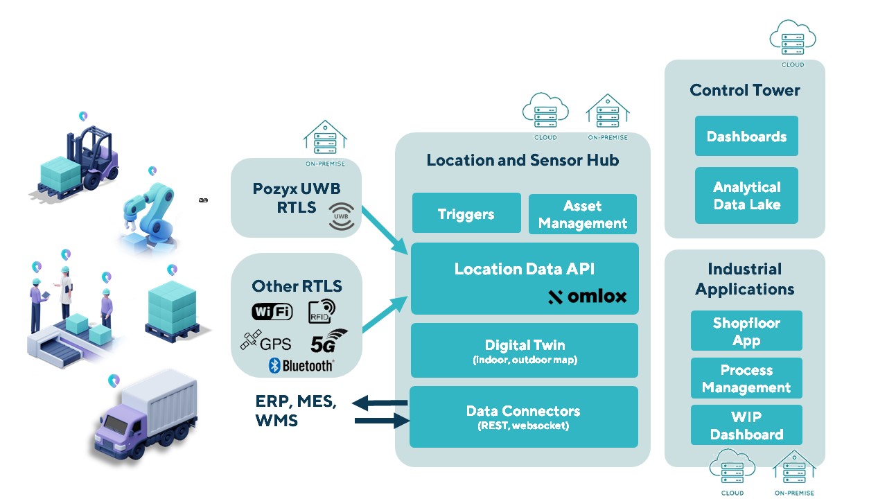
The Pozyx Platform is an asset tracking and identification solution for seamless indoor and outdoor tracking, based on the omlox hub and supporting multiple location technologies.
The omlox hub is an open standard for real-time location systems (RTLS) that combines location data from GPS, ultra-wideband, 5G, radio-frequency identification, Wi-Fi and Bluetooth.
The Pozyx Platform offers a seamless indoor/outdoor transition with zoom-in from a worldwide map to a detailed indoor map, showing highly accurate locations up to 10 cm. It is designed for smart manufacturing, providing a supply-chain solution that supports Industry 4.0.
It tracks and identifies any asset, providing real-time data to facilitate warehouse and inventory control, keep track of critical tools, and slash lost asset costs.
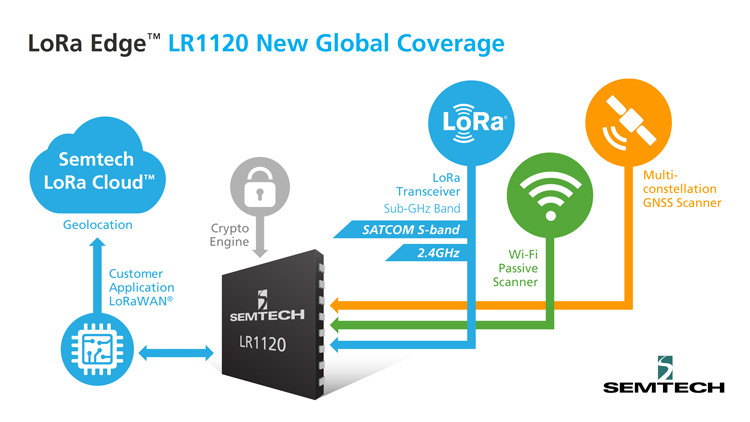
The new LoRa Edge LR1120 enables satellite-based networks and simplifies terrestrial network interoperability
Image: Semtech
Semtech Corp. has added multi-band capabilities to its LoRa Edge device-to-cloud geolocation platform.
The LoRa Edge LR1120 allows for direct satellite-connected internet of things (IoT) applications in supply-chain management and logistics with seamless low-power geolocation on a global scale, the company said.
“Semtech’s LoRa is targeting track and trace challenges faced by the logistics industry today with a geolocation IoT platform adapted to global transportation and mass-scale asset management,” said Marc Pégulu, vice president of IoT product marketing for Semtech’s Wireless and Sensing Products Group. “With the launch of multi-band LoRa support, coupled with LoRa Cloud services, it has never been easier to expand ubiquitous IoT connectivity and geolocation globally.”
With LoRa Edge LR1120, intercontinental logistics companies can leverage highly integrated, ultra-low-power trackers with enhanced interoperability, more versatile connectivity for a simpler operation, and global mobility across multiple regulatory regions, Semtech said. Additionally, the possibility to offer a low-power and low-cost sensor with satellite connectivity unlocks a multitude of use cases in infrastructure monitoring, agriculture and environmental monitoring that require deployment in remote areas, which tend to be capital intensive.
“Combining LoRa with small, relatively low-cost LEO satellites will change the game for LoRa and IoT,” said Christopher Taylor, director, RF & Wireless with Strategy Analytics. “Adding satellite communication capabilities in the S-band to LoRa can help replace aging SCADA monitoring and opens up new applications and markets, especially in remote regions. So far, LoRa has attracted the interest of several satellite companies including EchoStar and Lacuna.”
Key Features of LoRa Edge LR1120:
multi-band LoRa capability (sub-GHz, 2.4 GHz and licensed S-band for satellite) and multi-technology geolocation using GNSS for outdoor and Wi-Fi for indoor, as well as areas where satellite coverage is poor
LoRa Cloud geolocation solver, which transfers the location processing workload from the device to the cloud, making “deploy once” battery life possible
Infineon Technologies AG and Deeyook are collaborating on location solutions. Deeyook, a location-as-a-service (LaaS) company, has patented a tracking solution to determine indoor and outdoor locations of items, assets and employees.
The companies fused Deeyook’s ultra-precise algorithms into Infineon’s low-power AIROC Wi-Fi portfolio to enable an accurate, passive, ubiquitous and efficient location solution.
Deeyook specializes in wireless signal processing applicable to incumbent Wi-Fi/4G/5G modem firmware versions. The firmware extracts angles of wireless transmissions (direction finding, or DF), for commercial wireless tracking. Deeyook’s tracking capabilities are ultra-precise, providing location information within 10 cm/4 in, passively exploiting the install base of 1.7 billion wireless access points worldwide.
“There are many challenges when companies implement real-time location systems, primarily because tracking solutions, such as RFID, are not really ubiquitous. This is particularly acute with GPS, which has many shortcomings,” said Gideon Rottem, CEO and co-founder of Deeyook. “We created Deeyook to address these challenges — technology that is ubiquitous and can track things with the utmost precision indoors, outdoors and in bad weather. We are excited to work with Infineon because its AIROC Wi-Fi portfolio is reliable and power efficient.”
“Infineon’s mission is to make the world an easier, safer and greener place with our technologies through smart, connected devices,” said Sivaram Trikutam, senior director, IoT Compute and Wireless, Infineon Technologies. “These new IoT solutions support multiple location tracking technologies. Previously, Wi-Fi was not considered a viable option due to its power demands, while additionally, real-time locating system (RTLS) deployments required businesses to utilize custom solutions with costly infrastructure, engineering and labor-intensive installation.”
Harxon has introduced the HX-CUX005A to its family of helix antennas.
The HX-CUX005A is an embedded helix antenna designed for high-precision positioning. It offers superior satellite signal tracking, including GPS, GLONASS, Galileo and BeiDou as well as L-band correction service.
Upgraded with Wi-Fi and Bluetooth tunable (BT) for better integration, the HX-CUX005A is designed to be an all-in-one solution for surveying, unmanned aerial vehicles (UAVs), personnel and vehicle monitoring, and many more applications.
The powerful antenna has Harxon’s patented D-QHA technology and multi-point feeding technology. It is able to provide reliable and consistent signal tracking with centimeter-level accuracy by exhibiting a stable phase center, 2.5-dBi high gain with ultra-low signal loss, wide beam width and exceptional low-elevation satellite tracking.
In addition, the HX-CUX005A is optimized in circuit layout and equipped with robust pre-filtered low noise amplifier that guarantees excellent out-of-band rejection performance and strong multipath reduction capacity. In this way, unwanted electromagnetic interference is restrained for improved signal filtering over all GNSS frequency bands.
The integration of Wi-Fi and Bluetooth (2.4 GHz/5.8 GHz) provides 1-dBi gain (typical value) to enable easy connection and configuration for mobile device users. Its highly integrated design simplifies development process and reduces costs for device engineers, Harxon said.
Key Features of the HX-CUX005A
Comprehensive GNSS support: GPS, GLONASS, Galileo, BeiDou and L-band correction service
Centimeter phase-center repeatability, high gain at low elevation
Improved signal filtering and excellent multipath rejection
Weighs 10 grams in small form factor to facilitate integration
Integrated with Wi-Fi and Bluetooth tunable (2.4 GHz/5.8 GHz).
The solution delivers ultra-low power meter-accurate positioning both indoors and outdoors.
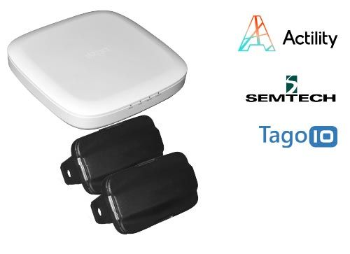
The kit allows solution providers and integrators to quickly evaluate this new technology and to experience how it reduces the cost and complexity of building a solution for locating and monitoring internet-0f-things (IoT) assets.
The LR1110 chipset, integrated to LoRa Edge, uses assisted GNSS (AGNSS) and Wi-Fi AP scanning, alongside standard LoRaWAN communications. It is bundled with Actility’s LoRaWAN network server (the ThingPark platform) and with the Tago.io application server.
ThingPark Enterprise delivers the data to Tago.io through a predefined interface. Tago.ai provides a mechanism for customers to route received location data to an actionable dashboard with the map location history, the data traffic history and other data.
The chipset has already been adapted by multiple companies such as Abeeway for its newest geolocation module.
Low-power geolocation
Semtech’s LR1110 is the first product in its new LoRa Edge platform — a highly versatile, low power, software-defined LoRa-based platform designed to enable a wide portfolio of applications for indoor and outdoor asset management.
Modular and configurable, the LR1110 can transition between outdoor and indoor activity automatically, using GPS satellite tracking for outdoor applications and Wi-Fi passive scanning for tracking indoor assets. It replaces the need to build different trackers for indoor or outdoor use or trackers that combine multiple location methods with a single chipset, reducing complexity and cost.
It contains the ultra-low power capabilities of a LoRa transceiver. This means that it can communicate over LoRaWAN and it can be used to acquire position coordinates either through GNSS or Wi-Fi signals. Instead of changing the batteries on asset trackers every three to six months with conventional Wi-Fi technology, LoRa Edge delivers low power consumption allowing battery lifetimes up to three years.
A crypto engine allows LoRaWAN keys to be stored inside the device for secure joining and communication. Modules can be securely activated from Semtech’s LoRa Cloud Device Activation Service.
Indoor location platform provides municipalities with emergency response and public safety solutions on existing Wi-Fi networks
InnerSpace, a Toronto-based company, is offering its Wi-Fi-based indoor location intelligence platform to support all levels of government. The platform analyzes patterns and movement in public spaces using existing Wi-Fi networks.
The platform is suitable for understanding the movement of people inside public spaces and can support emergency response strategies, social distancing programs and help smart cities implement effective security and public safety measures.
“In response to the global COVID-19 pandemic, we have accelerated the delivery of our public safety solution inFORCE,” said James Wu, CEO, InnerSpace. “Our platform processes RSSI [received signal strength indication] data in real time and returns the industry’s most accurate location data available today. By using public Wi-Fi access points, municipalities have a way to quickly roll out new solutions at city-wide scale.”
InnerSpace inFORCE was selected in a competitive process by the U.S. Department of Homeland Security, for its ability to use Wi-Fi to locate citizens and track emergency responders in an active shooter scenario.
The same platform can be used in a wide variety of emergency situations such as the current COVID-19 pandemic. In addition to the company’s tracking capabilities, it’s analytics dashboard gives public safety offices an unprecedented view into how people leverage public spaces.
“In times of emergency, it is reasonable to prioritize safety and public health to minimize the loss of human life,” said Cerys Goodall, president and COO, InnerSpace. “By providing municipalities with a system that can deliver line-of-sight into how people move in public spaces, we can inform response strategies, improve rescue efforts, and create an infrastructure to support better outcomes.”
InnerSpace inFORCE ingests RSSI data and returns accurate anonymous indoor locations. The information can be connected directly into emergency response communications systems, building management and security systems, or analyzed by InnerSpace to identify critical patterns and trends in people’s movements.
New modules enable entertainment, advanced connectivity features and next-generation artificial intelligence
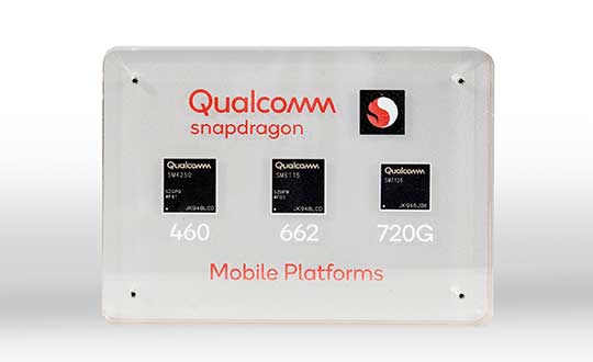
Qualcomm Technologies has launched three new mobile platforms — the Qualcomm Snapdragon 720G, 662 and 460 — to enable enhanced user experiences across connectivity, gaming and entertainment.
The new mobile platforms support dual-frequency (L1 and L5) GNSS to improve location positioning accuracy and robustness. The system-on-chip solutions also support the Indian NavIC (Navigation with Indian Constellation).
Seven constellations. For the first time supported on mobile, the Qualcomm Location Suite now supports up to seven satellite constellations concurrently, including the use of all of NavIC’s operating satellites for more accurate location performance, faster time-to-first-fix (TTFF) position acquisition, and improved robustness of location-based services.
“ISRO is satisfied with the efforts of Qualcomm Technologies Inc. towards incorporating NavIC and we urge OEMs to leverage it for future handset launches in India,” said K. Sivan, chairman, ISRO. “The availability of NavIC across multiple mobile platforms will help enhance the geolocation capabilities of smartphones in the region and bring the benefits of this indigenous solution to Indian consumers for their day-to-day use.”
The new modules also enable fast 4G connectivity speeds, deliver key Wi-Fi 6 features and integrated Bluetooth 5.1 with advanced audio via the Qualcomm FastConnect 6-series subsystems.
Artificial Intelligence. Designed to deliver new and improved AI user experiences across photography, voice assistants and virtually always-on scenarios for increased contextual awareness, the new platforms also feature the Qualcomm AI Engine and Qualcomm Sensing Hub.
“While we see a fast adoption of 5G across geographies globally, we do recognize the phenomenal boost that 4G has given towards enabling broadband connectivity for Indian consumers. 4G will continue to remain a focus area for Qualcomm Technologies for regions like India, where it will stay a key technology for connectivity,” said Rajen Vagadia, vice president and president, Qualcomm India Pvt. Ltd. “Our goal is to enable our partners to continue creating solutions that offer seamless connectivity access and exceptional mobile experiences, that consumers can count on.”
“Today’s smartphone users want fast, seamless connectivity, advanced features and long-lasting battery life,” said Kedar Kondap, vice president, product management, Qualcomm Technologies, Inc. “This expansion of our 4G lineup enables our partners to offer sophisticated solutions that meet global demand and enable a remarkable gaming experience across multiple tiers and price segments.”
Photo: Qualcomm
Snapdragon 720G
Snapdragon 720G reimagines extraordinary gaming and entertainment experiences with select Qualcomm Snapdragon Elite Gaming features, striking capture capabilities, and intelligent performance. Leveraging select Snapdragon Elite Gaming features from premium-tier mobile platforms, Snapdragon 720G delivers smooth HDR game play, dynamic color range and contrast, realistic and immersive in-game environments, and high-quality, synchronized sound with Qualcomm aptX Adaptive.
In addition to gaming, users will have a “home theater in their pocket” with HDR viewing and super-smooth video streaming with the Qualcomm Spectra 350L ISP, Qualcomm said. They can also capture 4K video or snap massive 192-megapixel photos.
Snapdragon 720G also features the latest fifth-generation Qualcomm AI Engine with the improved Qualcomm Hexagon Tensor Accelerator that will enable a host of new AI experiences for gaming, photography, voice assistants and virtually always-on contextual awareness.
The integrated Snapdragon X15 LTE modem supports 3-carrier aggregation, 4×4 MIMO on two carriers and 256-QAM modulation for fast download speeds up to 800 Mbps — allowing for quick app downloads and smooth video streaming and sharing.
In addition, Snapdragon 720G, with the FastConnect 6200 subsystem, virtually doubles Wi-Fi speed and range for online gaming and web browsing, compared to single antenna devices, while also delivering key Wi-Fi 6 features such as 8×8 sounding with multi-user MIMO for up to 2x improvement over competitive Wi-Fi 6 devices, Target Wake Time for up to 67% better power efficiency and the complete WPA3 security suite, as well as integrated Bluetooth 5.1 with advanced audio capabilities.
Finally, users will experience power savings and improved performance due to the Snapdragon 720G’s 8-nm process technology and upgraded CPU architecture.
Snapdragon 662
Snapdragon 662 brings astonishing camera and AI capabilities to the 6-series for the first time. It will feature the new Qualcomm Spectra 340T, which supports triple camera configurations and smooth switching between them — a first in the 6-series. A more robust ISP will enable support for photo capture in the HEIF file format for stunning image quality at half the file size.
The addition of the third-generation Qualcomm AI Engine with Hexagon Vector Extensions and the Qualcomm Spectra 340T will enable AI-based user experiences such as avatars, night photography, and face and voice authentication.
Snapdragon 662 also features the new Snapdragon X11 LTE modem with peak download speeds up to 390 Mbps thanks to 2-carrier aggregation, 2×2 MIMO and 256-QAM modulation, along with 150 Mbps peak uploads to support a snappy web browsing and social media experience.
Snapdragon 460
Snapdragon 460 boasts a gigantic leap in performance across the board in the 4-series, as well as significant boosts in connectivity, AI and camera improvements[1] for the next-generation of mass market smartphones. For the first time in the 4-series, Snapdragon 460 features performance CPU cores and an updated GPU architecture that translates into up to 70% and 60% increase in performance, respectively.
Overall system performance, meanwhile, delivers a 2x increase compared the previous generation. The Hexagon processor with Qualcomm Hexagon Vector eXtensions (HVX) is also introduced into the 4-series for the first time, thereby equipping it with a 3rd generation Qualcomm AI Engine and the Qualcomm Sensing Hub for new AI experiences for photography and voice assistance.
The Qualcomm Spectra 340 ISP is also among the many new additions to the 4-series, enabling the platform to capture stunning photographs and support for triple cameras. An integrated Snapdragon X11 LTE modem allows for download speeds up to 390 Mbps and uploads up to 150 Mbps.
To date, more than 85 commercial devices based on Snapdragon 7-series mobile platforms, more than 1600 commercial devices based on Snapdragon 6-series mobile platforms, and more than 2,500 commercial devices based on Snapdragon 4-series mobile platforms have been announced by global OEMs. Together, the 7-, 6- and 4-series amount to over 4,000 designs — an impressive feat for these segments.
Devices based on Snapdragon 720G are expected to be commercially available in Q1 2020 and devices based on Snapdragon 662 and 460 are expected to be commercially available by the end of 2020. For more information, please visit the product details pages for the Snapdragon 720G Mobile Platform, Snapdragon 662 Mobile Platform, and Snapdragon 460 Mobile Platform.
The U.S. Department of Transportation awarded contracts to 11 companies to demonstrate their technologies’ ability to act as a backup for GPS.
We wanted to know a bit more about what each of them were going to demonstrate, so we asked each for an explanation. Most provided just that, so much of what appears here is in their own words. A couple of companies sent us a whole lot more than 100 words and two did not respond. For those, we did our best with the materials they sent us and other publicly available materials.
Wi-Fi, Cellular, Ultra-Wideband
PhasorLab plans to demonstrate its Hyper Sync Net (HSN) technology as a backup to GPS-based PNT solutions. HSN is a self-organizing mobile mesh network capable of maintaining high-precision time (<<1 ns) and frequency (<<1 ppb) synchronization throughout the whole network as well as an instantaneous 3D locational map of the whole mesh network requiring as little as a single master reference node.
The HSN can be deployed either as a set of fixed reference nodes providing time and positioning references to other mobile UE clients, which is like a terrestrial version of GPS, or as a private ad-hoc mobile mesh network where all members are expected to be mobile.
Skyhook Technology’s system is powered by an immense database — created and maintained by Skyhook — that contains more than five billion geolocated access points and 200 million cell base station IDs, enabling it to accurately locate phones and devices worldwide. The user is not required to be connected to a Wi-Fi network for the system to work. The scan will simply detect Wi-Fi access points in the local area based on signals sent periodically (or on demand) according to the IEEE 802.11 specifications. Many devices will acquire information on as many as 100 access points in the surrounding area. Skyhook’s Wi-Fi positioning system (WPS) will compute an estimated end-user location based on each of the signal sources independently, and compute an optimal hybrid location estimate from all sources.
Fiber/Network
OPNT’s Global Terrestrial Timing Service (GTTS) provides GPS-independent timing-as-a-service over global fiber-based networks. Trading off cost versus service-level agreement (SLA)-backed accuracy, standard network connectivity offerings and bidirectional fibers are combined to meet application needs. As will be demonstrated with simulations of National Institute of Standards and Technology (NIST) and the two U.S. Naval Observatory (USNO) clocks, OPNT’s fully redundant solution receives its core Coordinated Universal Time (UTC) timing directly from the non-maskable interrupts (NMIs).
The demonstration will include sub-nanosecond stability with fault detection and glitchless recovery. Using the precision-timed fiber base, OPNT will also demonstrate precision monitoring of wireless signals with continuous, real-time corrections to keep the wireless transmissions and its local timing source in sync.
Seven Solutions’ core technology is called White Rabbit and was born at CERN. In this demonstration, Seven Solutions plans to showcase the performance of this technology, both on local and wide-area deployments, and explain the capabilities in terms of interoperability (integrating multiple synchronization technologies, i.e. IEEE 1588 PTP, NTP, PPS, 10-MHz clocks), scalability and resiliency. The goal is to provide a reference technology that can provide very stable time references over fiber in GPS-denied scenarios as a backup source or to complement other PNT solutions that need timing distribution at their core.
eLoran
Hellen Systems’ team said it is excited by its recent contract award to perform a GPS back-up demonstration for the Department of Transportation. Its team plans to demonstrate advanced eLoran technologies and offer resilient PNT services. Its next-generation solution will include a solid-state eLoran transmitter from Continental Electronics Corp. integrated with advanced timing and frequency products from Microsemi, a Microchip company. Hellen Systems also plans to deploy its proprietary receiver and reference systems developed by Microsemi.
Hellen Systems and program integrator L3Harris will manage the demonstration, with Booz Allen Hamilton providing technical and engineering leadership.
UrsaNav supplies eLoran, LFPhoenix and low-frequency technology for very wide-area, GPS-independent, PNT data and frequency services. UrsaNav was selected by the Volpe Center to demonstrate wide-area UTC time synchronization and distribution utilizing the former Loran site in Wildwood, New Jersey. UrsaNav will provide innovative new eLoran technology at the site in Wildwood to broadcast a UTC-synchronized eLoran signal. The demonstration will be conducted at one of the Volpe Center demonstration sites at Joint Base Cape Cod in Massachusetts or the Langley Research Center in Langley, Virginia. Either site can be utilized in the demonstration as eLoran signal transmissions from the Wildwood site can easily cover 700 miles or more.
Serco recently acquired Alion’s Naval Systems Business unit. This included a group working in New London, Connecticut, that has previously worked with and published on eLoran. While we did not get a response from Serco to our inquiry, eLoran is likely the technology the company will demonstrate.
Satellite
Globalstar-Echo Ridge’s system is based on Augmented Positioning System (APS) technology that uses ordinary signals from communications satellites (not special positioning/navigation signals, such as those from GPS satellites) to produce accurate position and timing information in compatible user devices. No new infrastructure is needed; Globalstar’s constellation of 24 low-Earth-orbit (LEO) satellites and Echo Ridge software and compatible devices at the user end provide the building blocks for the APS-based system. APS technology has been successfully demonstrated in diverse environments and incorporates multiple features to assure accurate PNT information under circumstances that can challenge or disable GPS/GNSS technology.
Satelles provides unique timing and location solutions delivered over the Iridium constellation of 66 LEO satellites. These timing and location signals are available anywhere on Earth without the need for local infrastructure, making the system perfect for complementing GPS and other location-based technologies.
Unlike standard GPS, these high-power signals can reach into many building structures. Most importantly, Satelles has customized the Iridium signal-in-space to provide a location-specific signature that can reliably prove (or authenticate) the location of a mobile device or other equipment, while being virtually impervious to spoofing and other attacks.
TRX Systems’ NEON Personnel Tracker provides ubiquitous 3D location, tracking and mapping. (Screenshot: TRX Systems)
Other
TRX Systems is the developer of NEON GPS-denied location solutions, delivering 3D location and mapping for dismount personnel where GPS is not available or is unreliable — including indoors, underground, in dense urban areas, and where GPS is found to be erroneous. NEON delivers ubiquitous, low-cost, GPS-denied location by using advanced sensor fusion, ranging and patented dynamic mapping algorithms that improve safety and situational awareness for military, public safety and industrial personnel.
NextNav’s Metropolitan Beacon System (MBS) is a 3GPP-compliant, terrestrial network of long-range broadcast beacons, transmitting a “GPS-like” signal in licensed spectrum in the sub-GHz range. The combination of an on-board atomic clock and the ability to self-synchronize allows the system to operate independent of GPS and provide full PNT services in its footprint. The ability to integrate the MBS signal in mass-market GPS and LTE chipsets can provide a seamless ability to provide full PNT services in the presence and absence of GPS. Because of its terrestrial nature, MBS is able to work indoors, in urban environments and outdoors; for barometer-equipped devices, MBS also enables floor-level altitude determination.
Volkswagen and NXP to Deliver Safety to European Roads with Rollout of Communicating Car Technology
NXP Semiconductors N.V., a provider of automotive semiconductors, has rolled out its RoadLINK V2X (vehicle to everything) communication solution in the new Volkswagen Golf.
The recently released eighth-generation Golf is the first volume European car model equipped with V2X, offering a major boost to the deployment of the technology on European roads and beyond.
Life-saving tech. The technology can prevent accidents by having cars communicate with each other, independent of car brands and without the support of cellular infrastructure.
“Road safety forms the core of VW’s commitment to its customers. As a high-volume manufacturer we aim to be a pioneer in this space,” said Johannes Neft, head of Vehicle Body Development for the Volkswagen brand. “The introduction of V2X, together with traffic infrastructure providers and other vehicle manufacturers, is a major milestone in this direction. Volkswagen includes this technology, which doesn’t involve any user fees, as a standard feature to accelerate V2X penetration in Europe.”
“Volkswagen has taken a bold step to seize the road safety initiative through the implementation of V2X,” said Torsten Lehman, senior vice president and general manager of Driver Assistance and Infotainment at NXP. “After proving our technology in more than one million test days globally, we are pleased that our RoadLINK technology, developed in cooperation with Cohda Wireless, was chosen to enable new levels of safety in Europe’s most popular car model, the new Golf.”
NXP and Volkswagen have closely collaborated for high reliability and performance, as well as for standardization of V2X communication that addresses cybersecurity and privacy protection.
V2X in Europe. Wi-Fi-based V2X is a mature technology that has been tested for more than 10 years. Today, 1,000 kilometers (km) of European roads are equipped with V2X technology based on Wi-Fi with 5,000 km planned through the end of 2019.
Its research and development, testing and standardization has occurred within a strong global ecosystem of suppliers and car manufacturers to ensure reliability in diverse road and traffic conditions.
Wi-Fi therefore forms the basis of the European standard that has been chosen for vehicle-to-vehicle and vehicle-to-infrastructure communication, according to NXP. An additional benefit is its availability independent of paid cellular services. Other developing cellular-based technologies can be added complementary to Wi-Fi-based V2X.
Migration to autonomous. V2X communication is set to become a critical part of advanced driving assistance systems (ADAS) and the migration to autonomous cars that communicate with each other and with traffic infrastructure.
The benefit of Wi-Fi-based V2X is its robust, low latency, real-time communication regardless of any car brands.
It enables awareness and communication between cars, road infrastructure like traffic lights or street signs, and other road users such as cyclists and pedestrians.
It is a technology that is collaborative, allowing it to “tap into” surrounding sensor data from mutually equipped cars to warn of hazards and prevent accidents.
V2X is a technology that complements other ADAS sensing technologies such as radar, lidar and cameras.
It helps vehicles to “see” more than a mile ahead and around corners to provide early warning of obstacles, hazards and road conditions.
It has the ability to “see” through objects, delivering more information than that obtained through line of sight only.
Its sensing capabilities are unaffected by poor weather conditions.
Skyhook is partnering with Rivetz to integrate Skyhook’s global mobile location services to enhance the Rivetz platform.
Skyhook is the operator of a worldwide independent location services platform. The company’s technology provides the foundation for mobile location services in the global market for connected devices.
Skyhook’s hybrid positioning system locates devices using observed radio signals — including GNSS, Wi-Fi and cellular — ensuring that all devices can be located in all environments.
By enabling Skyhook’s advanced location capabilities on the Rivetz Network of cybersecurity tools, Rivetz users can take advantage of location service protection in any signal environment, regardless of GPS availability.
Accurate and accessible device location services are a critical component of all end-to-end security solutions, particularly in regulated environments or other markets where trusted and verifiable location is a requirement.
“We are pleased to partner and collaborate with Rivetz, a trusted leader in decentralized mobile security,” said Kipp Jones, Chief Technology Evangelist of Skyhook. “We share the values that our products must be built on the pillars of trust and respect for individual privacy. We look forward to providing Skyhook’s industry-leading location services to the Rivetz Network.”
“We are proud to join forces with Skyhook to enable powerful location services to the Rivetz Network,” said Steven Sprague, co-founder and CEO of Rivetz. “A simple and safe security model is our greatest priority, and precise device location is a cornerstone of protecting our cybersecurity solutions.”
Rivetz’s security solutions hinge upon access to the Trusted Execution Environment (TEE), which is an isolated, measured computer environment separate from the operating system. By provisioning all digital transactions through the TEE, Rivetz assures that users’ private keys cannot be altered or stolen if the operating system were tampered with or infected by malware.
The device combines u-blox GNSS, 4G and Wi-Fi technology, eliminating the need to equip vehicles with a separate mobile Wi‑Fi hotspot.
According to the companies, the StartLink TrackerWi‑Fi is suitable for applications for connected cars, telematics, vehicle diagnostics, fleet management, vehicle security, usage-based insurance, and rental and leasing service companies.
The internet of things (IoT) and connected-car initiatives are providing rental car companies and transportation and logistics firms with tools to track vehicles, preemptively detect and diagnose disturbances from a distance, and monitor the behavior of their drivers in real time. ERM has more than 1.8 million vehicle fleet-tracking devices deployed on roads world-wide.
As onboard Wi‑Fi becomes increasingly widespread, many companies are fitting vehicles with Wi‑Fi hotspots to offer drivers and passengers internet access. With its integrated Wi‑Fi hotspot, ERM’s StarLink TrackerWi‑Fi lets users tap into the cellular 4G connectivity to transfer telematics data to the fleet manager. This makes it possible to send real-time telematics data to the driver’s smart device or onboard infotainment system, and it also reduces the number of SIM cards needed from one per device to one per vehicle.
Sourcing the GNSS tracking, cellular 4G LTE, and Wi‑Fi technology from u-blox played a key role in achieving the device’s fast time to market. By using u‑blox’s pre-tested positioning and communications modules with integrated software, the manufacturer was able to cut the time needed for production and development by several months.
“We saw an opportunity to provide more values to our customers by adding Wi‑Fi hot spot functionality to our StarLink Tracker, our leading telematics product, but knew that we had to be quick to stay ahead of the game,” said Kfir Lavi, senior vice president of ERM Advanced Telematics.
“Our partners are always at the top of our priorities, and we are working to adapt our offerings to the market demands and the changing needs of their customers. Working with u‑blox as the provider of the positioning and wireless communication technology helped us move from concept to commercialization in under six months and provide our partners with an advanced product in a short time,” Lavi said.
“This successful collaboration demonstrates that we have evolved from a provider of individual technologies, namely GNSS positioning, cellular 4G connectivity, or short range radio communication, to a provider of solutions that bundle these technologies,” said Thomas Seiler, CEO of u-blox. “We are seeing increased demand for such bundled solutions and are convinced that the close integration of our technology portfolio offers our customers the unique ability to jump-start even challenging projects on extremely short notice.”