Collins Aerospace announced that its miniature PLGR engine – M-code (MPE-M) receiver has received approval from the GPS Directorate. Collins Aerospace’s Mike Shepherd talks more about the approval at Xponential 2019, which took place April 29-May 2 in Chicago.
Tag: Xponential 2019
-
Exploring, once again, the brave new world of UAVs
Welcome to Part 2 of our coverage of the mammoth AUVSI Xponential 2019 show in Chicago, which drew 8,000 attendees, featured 300+ speakers on its technical program, and furnished a temporary home for more than 800 exhibitors. It was “Everything Unmanned” and a challenge to cover. Last month we looked primarily at new vehicles. This month’s column focuses on sensors, capabilities and apps aboard those and other airborne drones — and even an anti-drone drone!
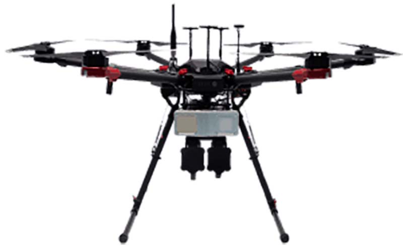
Sagetech: For UAVs to gain entry to the US National Airspace System (NAS) and to other controlled airspace all around the world, sense-and-avoid capability is paramount. Sagetech comes from the world of Mode-S transponders, with which the majority of piloted aircraft are equipped. These devices transmit aircraft identification and provide the moving IDs on air-traffic controller display monitors. In the military sector, Identification Friend or Foe (IFF) interrogator-transponders enable similarly equipped aircraft of NATO countries to determine which are friendly aircraft within their immediate airspace, and which are not.
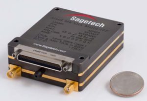
The MX12B Mode 5 IFF with FAA-certified civil modes. (Photo: Sagetech) Sagetech has just released a micro-mode 5 MX12B aviation transponder that enables small unmanned aircraft to interoperate within NATO airborne units. The transponders weigh around 10lb, so mil-spec UAVs operating in NATO airspace can now also carry this light-weight unit.
For civilian UAVs, GPS has been added to provide aircraft position outputs in Automatic Dependent Surveillance Broadcast (ADS–B) message format, allowing other aircraft and UAVs to receive a vehicle’s location. The Sagetech ADS-B transponder is small, certified to Federal Aviation Administration (FAA) standards (TSO C-166b) and is affordable. Boeing Scan-Eagle UAVs apparently already carry Sagetech transponder capability.
The tailBeacon ADS-B retrofit. (Photo: uAvionics) uAvionix: Another avionics supplier has brought out certified ADS-B capable transponders, but with a novel way to add the required capability to general aviation (GA) aircraft, typically smaller private planes. The FAA has mandated that all aircraft should be fitted with ADS-B capability by January 1, 2020 in order to fly within controlled airspace, so uAvionix has simplified ADS-B retrofit for older GA aircraft.
All aircraft have wingtip and/or rear-tail beacon lights; this update replaces their existing beacon with a light which also includes ADS-B capability when paired with the aircraft transponder.
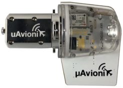
The FYXnav TSO CERTIFIED GPS navigation source. (Photo: uAvionics) uAvionix also supplies a couple of GPS sensors for external mounting on UAVs: the FYXnav sensor is FAA-certified to TSO-C199 Traffic Awareness Beacon System Class B.
Sensefly released a new inspection application for their eBeeX UAV, specifically designed for solar farms. With a dual thermal/video sensor for data collection and data processing using application-specific Raptor Maps software, Sensefly claims to reduce the inspection time required for a 150MW solar farm to around 1 day, a 300-times improvement on ground inspection using a hand-held thermographic sensor.
Provided an inspection operation could support five 70-minute eBee-X flights during one day, the UAV could over-fly up to 161 acres of solar panels at an altitude of 138ft, gathering anomalies during each flight. This adds up to 150MW of solar panels over the 5 flights. Sensefly claims this to be twice as fast as with multi-rotor dones. The Raptor Maps software then generates an inspection report identifying each anomaly, using the eBee X’s video and thermal imagery to identify, classify, and localize the detected problems.
The Fortem DroneHunter intercept drone. (Photo: Fortem) Fortem makes an anti-drone defense combining a radar detection system with a DroneHunter drone that attacks other UAVs, releasing an 80ft net to capture intruders. For those nefarious drones which are hardened against RF countermeasures, this system is also touted as capable of recovering the offending drone without damage, returning it to the operator in a net at the end of a tether. The DroneHunter flies autonomously on its intercept mission, carrying a compact radar system integrated with a ballistic net release system.
Septentrio continued promotion of its Mosaic chip-level GNSS at Xponential. The new chip uses the same proven core DSP with a new RF front-end and a new processor, working with more than 30 signals from the existing six GNSS constellations, and with L-band and satellite-based augmentation systems (SBAS).
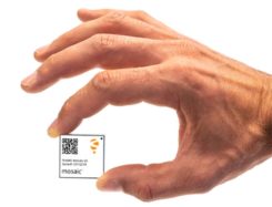
Septentrio’s Mosaic chip-level GNSS. (Photo: Septentrio) The chip appears to be aimed at the high-precision market, replacing the AsteRx-m2 board level receiver family.
The chip runs Septentrio RTK algorithms, is quite small (1.29 x 1.29 x 0.15 in), is designed for high-volume surface mount manufacture, and comes with a set of popular interfaces. The chip is sampling now, with production planned for later this year.
NovAtel is growing, opening new offices in the US and needing more local real-estate to fit its headquarters in Calgary, Canada. The company is now part of Hexagon Positioning Intelligence (Hexagon PI), a partial re-branding that includes VERIPOS correction services and recently purchased AutonomousStuff, specializing in ground vehicles. Each organization still operates individually through its own brands. On the NovAtel booth, existing products were presented through a number of new applications, including those of the growing mil-spec products group.
Summary. While AUVSI Xponential was over in early May, the companies who were there have not rested. All are developing new approaches for UAVs and unmanned ground vehicles, sensor systems for even wider applications than seen in Chicago, and all manner of other added capabilities. This business only gets bigger and more innovative.
-
uAvionix introduces truFYX GPS, transponder at Xponential 2019
uAvionix Chief Operating Officer Ryan Braun discusses the company’s truFYX GPS and transponder at Xponential 2019, which took place April 29-May 2 in Chicago.
-

XM2 drones play pivotal role in film industry
When it comes to producing film imagery, it’s all about perspective.
Picture this: You’re in a courtyard surrounded by four high-rise buildings, looking up. You’re tasked with flying a drone equipped with a movie camera between two of the buildings, and then up one of them.
It’s a challenge, but perspective is critical when it comes to filming technology-focused movies like Pacific Rim: Uprising.
High-resolution imagery has become a critical component for Hollywood film producers over the years, and drones have played a paramount role in offering unique viewpoints.
More importantly, drones allow users to capture imagery that humans alone can’t produce.
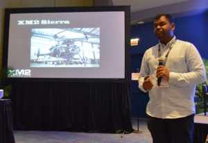
XM2’s Aaron Corera discusses the company’s drone imagery at Xponential 2019. (Photo: Allison Barwacz) XM2, an aerial cinematography and photography company based in Melbourne, Australia, uses drones to capture this compelling imagery. The company has worked on a number of big-name projects, including Pacific Rim: Uprising, Thor: Ragnarok, Aquaman, season two of Westworld, Pirates of the Caribbean: Dead Men Tell No Tales and Star Wars: Episode IX.
“Star Wars: Episode IX was certainly a big challenge,” said Aaron Corera, drone pilot and safety manager at XM2, at an education session at Xponential 2019. “It was a massive challenge logistically to get all of our equipment over there, and then in an environment where there’s very little infrastructure, essentially, to be able to do some high-pressure tasks. It’s just a matter of being well prepared, being switched on and working through a checklist to make sure every box is being ticked.”
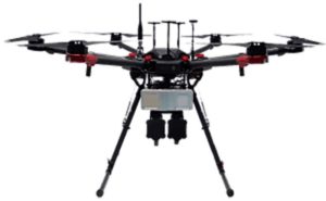
The company has manufactured a number of its own drones to meet the needs of its clients. One of its drones — the XM2 Sierra — is capable of carrying payloads up to 66 pounds.
“It is designed to be able to carry cameras that traditionally aren’t drone-based cameras,” Corera said. “That aircraft can carry the same cameras that are being used for the ground-based shooting, and that’s a big advantage. Having all platforms using the cameras saves them time in post-production.”
The company’s other house-manufactured drones include the Tango, Echo and Inspire Pro 2, which have been deployed over a number of the company’s projects.
The work didn’t come immediately, though. The 14-person staff at XM2 has only been working in the film industry for about seven years, Corera said.
“The work came in bits and pieces, and we gained momentum into it a little bit, then realized, ‘There’s a real opportunity here,’” he added.
One of the biggest challenges the company has had to face is unfamiliarity with the products and what XM2 can offer.
“I think one of the challenges includes familiarity, ultimately,” Corera said. “And that’s familiarity in the systems for the client and what it can and can’t do.”
Because a lot of people aren’t familiar with drones and the legal requirements to fly them, XM2 has had to find alternatives for client requests, as well as educate and ensure the safety of the people working around them.
“From the people management side of things, when we’re operating on a film set, it’s about coordination between the people that are involved in the shot itself and then the people that are managing the film set,” Corera said. “And then there will generally be on-set safety, as well. We’ll have a briefing in the morning, and explain what we’ve got planned for the day.
“When it comes to a specific shot, we take it upon ourselves to know exactly where everyone is, exactly what they’re doing and where they’re going. We make sure everyone knows what the plan is and what to do in case something goes wrong. It’s a combination of technical safety protocols and people safety protocols.”
Still, as technology evolves, the demand for high-resolution, drone imagery does, too. It’s all about perspective and, more importantly, capturing imagery from a viewpoint otherwise unseen.
-

Honeywell emphasizes ruggedized feature of IMU at Xponential 2019

Photo: HoneyWell Honeywell displayed its HG4930 MEMS-based inertial measurement unit (IMU) at Xponential 2019, which took place April 29-May 2 in Chicago.
The company emphasized the IMU’s rugged design, which the company says allows the IMU to meet the needs of the most demanding users. The HG4930 also features gyroscopes, accelerometers and an internal environmental isolation system.
Check out the video below, which showcases the HG4930 being treated as a hockey puck.
According to Honeywell, the HG4930 can be used for applications in the agriculture, automotive, communication, construction, energy, inspection, mapping, marine, mining, robotics, surveillance and transportation industries.
-
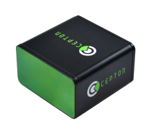
Cepton unveils long-range lidar scanner for UAVs
Photo: Cepton Cepton Technologies Inc., a provider of 3D lidar solutions for automotive, industrial, security and mapping applications, has unveiled its newest lidar scanner, the SORA-P60L.
Cepton unveiled the SORA-P60L at AUVSI Xponential 2019.
Part of Cepton’s SORA family of lidar scanners, the new scanner is purpose-built to deliver long-range, high-resolution imaging for unmanned aerial vehicles (UAVs).
The SORA-P60L offers a 400-Hz frame rate, enabling drones to fly faster while maintaining high point-cloud density. With a 550-gram payload, the SORA-P60L prolongs UAV flight time allowing more ground to be covered in a single trip, the company said.
Cepton’s unique Micro-Motion Technology faces all lasers downward at all times, providing a dense, uniform point cloud that, in combination with the high scan rate, makes it suitable for fixed-wing and fast-moving rotary-wing UAVs.
“Cepton’s SORA-P60L leads the lidar industry with its best-in-class point cloud density that provides superior imaging for UAVs,” said Neil Huntingdon, Cepton’s VP of business development. “With the affordable price point, long-range capabilities and high frame rate of SORA-P60L, UAVs can capture data faster and build more accurate maps. SORA-P60L is our first product from the SORA family that we have unveiled this year. We see a lot of opportunities for this unique sensor in other markets and have a number of products in development that will be revealed later this year.”
-

DroneShield releases body-worn drone detector
RfPatrol. (Photo: DroneShield) DroneShield Ltd. has released a body-worn drone detection product, RfPatrol. Weighing under 1 kilogram, the mobile unit is expected to be of significant interest to a range of DroneShield’s customer base globally, across military, law enforcement, security and VIP markets.
DroneShield made the announcement at AUVSI Exponential 2019, being held this week in Chicago.
RfPatrol is a passive (non-emitting) product, which substantially broadens the range of customers to whom the product is lawfully available. It was developed in response to customer interest.
Already, a small quantity of the RfPatrol units has been ordered by a western country’s defense department, for evaluation with a potential larger order in the future.
“We are excited to launch RfPatrol,” said DroneShield CEO Oleg Vornik. “Due to its miniaturized/body-worn nature, substantially larger customer universe due to its non-emitting nature, and a relatively lower price point compared to fixed-site products, we expect it to have substantial appeal. In addition to being able to be used as a stand-alone, it is a perfect companion to our DroneGun product.”
-
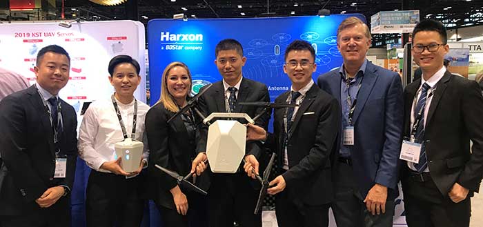
Harxon GNSS antennas ready for UAVs and UAV base stations
The Harxon team at AUVSI Xponential. (Photo: Harxon) Harxon showcased its full range of UAV antennas and technologies for various UAV applications — especially for UAV base stations — at AUVSI Xponential, which took place April 30-May 2 in Chicago.
Harxon’s newly launched X-Survey antenna offers a 4-in-1 design for multi-constellation GNSS signal reception. It integrates Wi-Fi, Bluetooth and 4G modules for easy integration into real-time kinematic (RTK) systems.
It also ensures centimeter accuracy for precision positioning of UAVs, and stability of signal transmission, which provides the navigation and communication performance required by UAV base stations.
Additional UAV antenna products and technologies on display at booth #2218 include the HX-CH7011A and HX-CU7001A, new OEM antennas with small size and low weight, but with high gain and a stable phase center. Other available antennas include HX-CH7603A, HX-CH6601A, HX-CH7603A and HX-CSX601A for UAV and surveying applications.
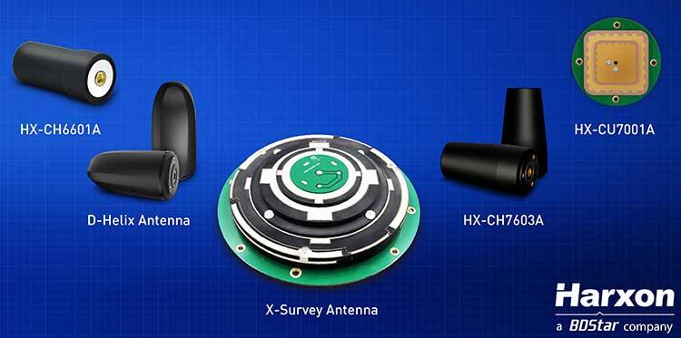
Image: Harxon Skycatch collaboration. Harxon has established strategic relationships with many industrial enterprises, such as Skycatch. Skycatch is an industrial data-collection and analytics company that focuses on indexing and extracting critical information. It provides combination GNSS base station and drone data-processing solutions that deliver high accuracy maps and point clouds in the 30 minutes or less.
Harxon — which specializes in GNSS positioning and navigation — is collaborating with Skycatch to give customers the opportunity to improve their UAV base station mapping solutions, and to maximize UAV operation efficiency and reliability.
High-precision GNSS solutions. The UAV industry, driven by new technologies, is one of the most dynamic growth sectors in the construction industry. The next phase of the drone revolution is flying towards standardization with precision solutions.
Harxon’s high-precision GNSS positioning technologies have been widely used in UAV-related applications, including UAV base stations, UAV power patrols, plant protection and machine control.
-
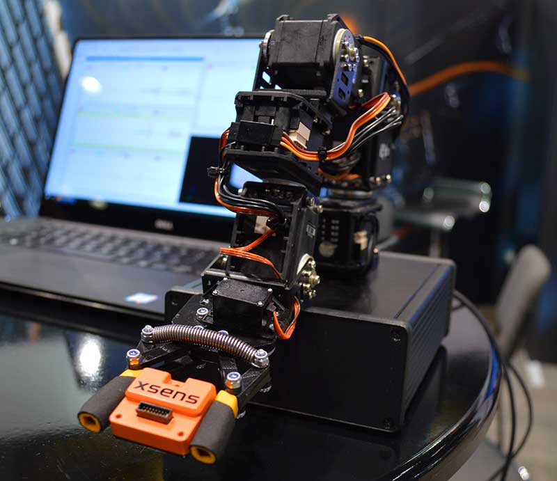
Xsens launches MTi 600 series of inertial sensors at AUVSI show

Photo: Allison Barwacz New MTi 600-series with flexible interfacing options is backed by software development suite for easy integration into space-restricted host systems such as drones, Xsens said.
The MTi 600-series is a generation of inertial motion sensors which set a new standard in the market for their small size, industrial-grade performance and competitive pricing, Xsens added.
The new MTi 600-series of inertial sensors, supplied in a 31.5mm x 28.0mm x 13.0mm IP51-rated case, produce roll and pitch readings accurate to ±0.2 degrees. GNSS-assisted heading (yaw) measurements are accurate to ±1.0°. Among the products’ new features are a CAN bus interface and NMEA compatibility.
To achieve this performance, Xsens has applied numerous innovations in its latest sensor fusion algorithms, which optimize the output from new accelerometer, gyroscope and magnetometer components.
Photo: Xsens The MTi 600-series modules are the first from Xsens to include an NMEA-compatible interface for GNSS receivers. This means that users can choose any GNSS receiver chip, module or system to work alongside the MTi-670, a GNSS/INS device that supplements the pitch, roll and yaw outputs available from other MTi 600-series products with global positioning information.
Xsens is demonstrating the high performance of the new modules at its stand 2627 at AUVSI Xponential, taking place in Chicago this week.
The MTi 600-series modules are available for sampling on request to Xsens. Volume production is expected to begin in July.
-
Topcon showcases Falcon 8+ drone, Sirius Pro and receiver boards at Xponential 2019
Topcon Positioning Group’s Dave Henderson offers a rundown on the company’s latest products, including the Falcon 8+ drone, Sirius Pro, MR-2 modular receiver, and B210 and B125 receiver boards, at Xponential 2019.
-

Live from AUVSI’s Xponential 2019
 The GPS World and Geospatial Solutions staff are reporting live from the Association for Unmanned Vehicle Systems International’s (AUVSI’s) Xponential 2019 April 29-May 2 in Chicago.
The event convenes the global community of commercial and defense leaders in intelligent robotics, drones and unmanned systems. Check out news, photos and videos from the show.
NEWS
- XM2 drones play pivotal role in film industry (5/17/19)
- Honeywell emphasizes ruggedized feature of IMU at Xponential 2019 (5/10/19)
- Cepton unveils long-range lidar for UAVs (5/6/19)
- DroneShield releases body-worn drone detector (5/1/19)
- Harxon GNSS antennas ready for UAVs and UAV base stations (5/1/19)
- Xsens launches MTi 600 series of inertial sensors at AUVSI show (5/1/19)
- SBG Systems debuts line of inertial navigation systems at Xponential 2019 (4/30/19)
- AUVSI, Airports Council announce UAS mitigation task force (4/30/19)
- Tallysman releases new UAV helical GNSS antennas (4/30/19)
- 3DR and Wingtra partner on aerial surveying solution (4/30/19)
- Raytheon system downs multiple drones in US Air Force exercise (4/30/19)
- GE Aviation brings advanced avionics computing to unmanned vehicles (4/30/19)
- Robotic Research provides navigation system for GPS-denied areas (4/29/19)
- GE Aviation and Auterion team on commercial drone platform (4/29/19)
- FlytBase to launch FlytGCS for BVLOS drone operation (4/26/19)
- Ohio UAS Center, AFRL to test Skyvision drone detection (4/26/19)
- Deseret UAS to showcase technologies at AUVSI Xponential (4/26/19)
- Teledyne Imaging showcases mapping, object recognition and tracking tech at AUVSI (4/25/19)
- Attollo Engineering introduces WASP-200 laser rangefinder (4/24/19)
- Self-driving work zone vehicles enhance safety (4/24/19)
- How lidar boosts the value of mobile mapping (4/23/19)
- Harris and Grand Sky partner on UAS BVLOS super corridor (4/23/19)
- Mobilicom to present smart drone solution at Xponential 2019 (4/23/19)
- Drone aids archaeology in Scotland (4/22/19)
- UAvionix partners with CubePilot on ADS-B IN for carrier board (04/18/19)
- What’s coming to AUVSI Xponential + UAV misHAPS by Tony Murfin (4/17/19)
- Quanta UAV INS/GNSS improves UAV-based surveying (04/16/19)
- UAvionix offers testing of CNPC command link radios for UAS (04/16/19)
VIDEOS
Click the icon in the top left hand corner to choose the video you’d like to watch.
