Abstracts for the ION GNSS+ 2021 show, “GNSS + Other Sensors in Today’s Marketplace,” are due March 5.
ION GNSS+ 2021 will be held Sept. 20-24 at the St. Louis Union Station Hotel. The show will also include a virtual option.
The 2021 show will feature in-person presentations with video presentations for remote viewers. It’ll also cover two tracks: commercial and policy tracks, and research tracks.
The commercial and policy tracks will include high performance and safety critical applications, status and future trends in GNSS, and mass market and commercial applications. The research tracks will include multisensor and autonomous navigation, algorithms and methods, and advanced GNSS technologies.
Authors whose abstracts are accepted in these sessions (either as a primary or as an alternate presenter) will have the option to have their papers peer-reviewed.
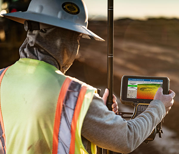
The Trimble TSC5 Controller boasts a 5-inch screen, keypad keypad and all-day battery. (Photo: Trimble)
Trimble has released the TSC5 Controller, a rugged, lightweight field data controller for land construction and surveying.
According to Trimble, the TSC5 Controller, built for practical, everyday tasks, combines high performance and dependability so professionals can complete tasks efficiently and accurately.
“Surveyors expect to encounter challenging environments and must rely on their equipment to perform as expected in harsh conditions,” said Ron Bisio, senior vice president, Trimble Geospatial. “The TSC5 controller is a high-value, reliable solution that land surveyors can leverage for field data collection tasks performed all day, every day.”
The controller has a 5-inch screen, keypad keypad and all-day battery for reliable field data collection. It also is resistant to shock, dust and water, and features an anti-glare screen and backlit alphanumeric keypad.
The Trimble TSC5 Controller uses an Android 10 operating system and is fully integrated with Trimble’s land and construction surveying instruments and software packages, including Trimble Access 2021 Field Software, Trimble Siteworks Software. It’s also compatible with the Trimble EMPOWER Module system, which includes the ability to add the EM100 (GNSS), EM11X family (RFID/Barcode) and EM120 (long-range radio) modules.
“Civil construction surveyors trust Trimble to provide rugged, reliable hardware that connects them to the Trimble Connected Construction ecosystem,” said Scott Crozier, vice president, Trimble Civil Construction. “The TSC5 is a great addition to our family of connected controllers, giving contractors the ability to choose the solution that best fits their needs and budget.”
The Trimble TSC5 Controller running the Trimble Access field software is now available through Trimble’s geospatial distribution partners.
The Trimble TSC5 Controller with the Siteworks SE Starter Edition. (Photo: Trimble)
Lockheed Martin, the prime contractor for GPS III/IIIF, selected L3Harris in 2018 to design and build the first two fully-digital MDUs, the heart of the satellite’s navigation payload. (Artist rendering: Lockheed Martin)
L3Harris Technologies has received contracts totaling $137 million for four navigation payload Mission Data Units (MDU) for future GPS III Follow-On (GPS IIIF) satellites.
Lockheed Martin, the prime contractor for GPS III/IIIF, selected L3Harris in 2018 to design and build the first two fully-digital MDUs, the heart of the satellite’s navigation payload. The MDU generates more powerful GPS signals and assures clock operations for GPS users, L3Harris said.
“The digital MDU is flexible enough to adapt to advances in GPS technology and future changes in mission needs,” said Ed Zoiss, president, Space and Airborne Systems, L3Harris. “The new MDU will also support a smooth transition for the U.S. Space Force’s GPS OCX ground control segment.”
The U.S. Space Force expects the first GPS IIIF satellite, which builds on GPS III adding new capabilities and technology, to be available for launch in 2026. According to L3Harris, the GPS IIIF MDU will provide improved capabilities over L3Harris’ 70-percent-digital MDU on the first ten GPS III satellites. The first four GPS III satellites have successfully launched and are now operational in the GPS constellation.
L3Harris Technologies is a global aerospace and defense technology innovator, delivering end-to-end solutions that meet customers’ mission-critical needs. The company provides advanced defense and commercial technologies across air, land, sea, space and cyber domains.
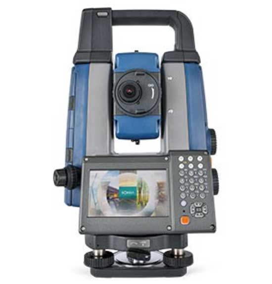
Sokkia has launched two robotic total stations designed to improve job site productivity: the iX-1200 and iX-600.
According to Sokkia, the total stations, designed as a part of a full workflow solution, are professional-level positioning tools for survey and layout in the building construction and infrastructure trades. They’re engineered for integration with field controllers, software and GNSS receivers.
In addition, advanced users can take measurements in almost any environment while switching to the most appropriate technology — total station measurement integrated with GNSS measurement — through an optional upgrade to Hybrid Positioning technology, Sokkia said. The stations also can be seamlessly integrated into BIM workflows.
“The high-performance technologies incorporated into the design provide increased prism-tracking strength,” said Ray Kerwin, director of global product planning. “Through a combination of optical sensing and ultrasonic motors, UltraTrac technology helps users stay locked onto the prism — and productive with less down time resulting from the need to reacquire prism lock — even in dynamic job site conditions. The system also features the RC-PR5A remote controller option used on the prism pole so the user can quickly and simply reestablish the connection between prism and total station.”
The total stations, available in multiple accuracy models, can be used with the SHC6000 field controller and GeoPro or MAGNET Field software for optimal performance, Sokkia added.
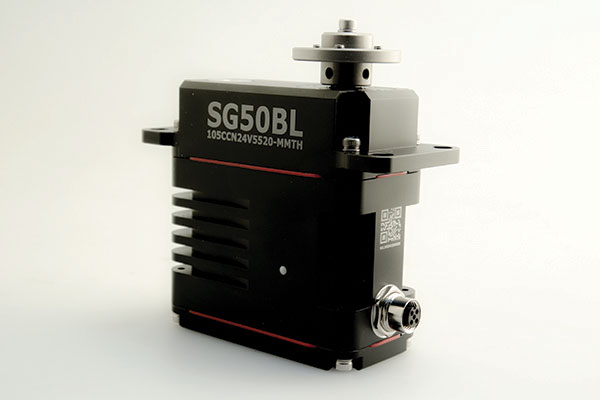
The SG50BL, designed with robust steel gears and a high-performance brushless motor, is capable of operating at a voltage range of 18 to 32 volts, the company said.
The actuator features a programmable digital circuit with a MOSFET amplifier; a BLDC motor; a magnetic encoder position sensor; five hardened steel gears low gear backlash (less than .5°); four ball bearing supported output shaft; nine needle bearing supported idlers; rugged anodized aluminum alloy case; and an IP68 waterproof rating.
The SG50BL also is capable of 360° proportional rotation and boasts T4131012051-000 TE connectivity. It includes CAN 2.0 A/B or UAVCAN control options, customization and modification options, and custom connector options.
Founded in 1973, Hitec designs and produces high quality actuators and radio control components for a variety of applications and demands.
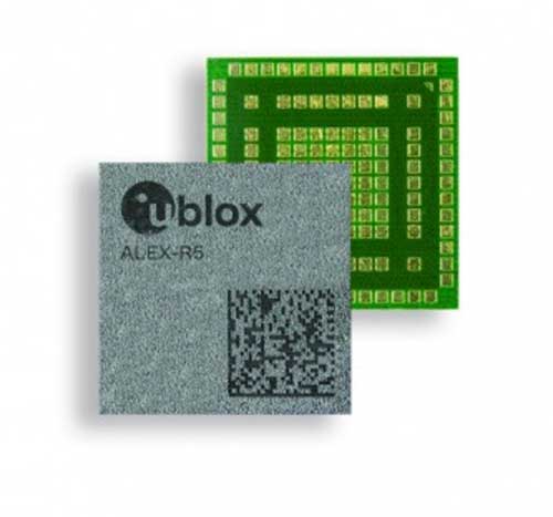
U-blox has debuted the ALEX-R5, a miniature cellular module that integrates low power wide area connectivity and GNSS technology into an ultra-small system-in-package (SiP) form factor.
According to u-blox, ALEX-R5 is based on the secure UBX-R5 LTE-M/NB-IoT chipset platform with out-of-the-box Secure Cloud functionality and the u‑blox M8 GNSS chip for world-class location accuracy.
The ALEX-R5 features a 14 x 14-mm footprint, achieved as a result of its SiP design. Its 23-dBm cellular transmission power guarantees end devices operate effectively in all signal conditions and a dedicated GNSS antenna interface that enables fully independent, simultaneous operation of the u‑blox M8 GNSS chip.
The ALEX-R5 is optimized for power-sensitive and battery-dependent applications, as well as size-constrained applications such as wearables and connected medical devices. It achieves this by leveraging the lower power modes of the u‑blox UBX-R5 and UBX-M8 chipsets and giving users options to further balance power consumption and performance using GNSS Super-E mode, u-blox said.
Its rugged SiP construction makes it a perfect fit for harsh environments, where moisture or vibration would be a concern for conventional modules. ALEX-R5 is rated at moisture sensitivity level 3, offering reduced handling and device production complexity, u-blox added.
Finally, the ALEX-R5 future-proofs IoT devices and solutions by enabling customers to software upgrade deployed devices for compatibility with 5G networks, u-blox said. This will offer a seamless transition to the next generation of cellular technology as 5G networks are rolled out by mobile operators.
Engineering samples of the ALEX-R5 SiP will be available by the first quarter of 2021.
According to DSI, the event will bring together members of the military services, Department of Defense (DoD), federal government, industry and academia in a “town hall” style forum to discuss how important GPS and space-based PNT systems are to the overall resilience of the warfighter, as well as critical infrastructure across the United States and abroad.
The 2021 Assured PNT Summit also will offer senior-level insight into how the U.S. military has been a leader in integrating PNT into its everyday operations and how such capabilities have become vital to the military’s ability to shape the global arena, deter aggression, and fight and win wars.
Confirmed speakers for this year’s event include William Nelson, SES, director, APNT CFT, Army Futures Command; Brig. Gen. Heather L. Pringle, USAF, commander, Air Force Research Laboratory; Anthony C. Smith, SES, director, C3I, DoD CIO; Richard De Fatta, SES, director, U.S. Army Space & Missile Defense Center of Excellence; Cordell “Del” DeLaPena, SES, program executive officer for Space Production Space & Missile Systems Center, USAF; Harold W. Martin III, SES, director, National Coordination Office for Space-Based Positioning, Navigation and Timing; and Col. Jason Joose, USA, chief of staff/APNT signature effort lead, Army Futures Command.
A number of topics will be covered at the 2021 Assured PNT Summit, including:
Leading current DoD initiatives toward integrating new PNT capabilities to help the Warfighter remain resilient in a dynamic threat environment;
Synchronizing PNT, navigation warfare and space capability development efforts across the Army to help reduce key capability gaps;
Delivering resilient, affordable and sustainable space capabilities such as modernized GPS to enhance warfighter superiority;
Providing alternate PNT for potential GPS-denied environments;
Accelerating the implementation of cutting-edge Air Force research projects such as NTS-3 GPS Satellite to provide the most value to the warfighter;
Developing critical PNT-related products to enable a Soldier’s PNT capabilities in all warfighting domains;
Overseeing the collection of GPS-related information from multiple federal agencies in an effort to improve and maintain space-based PNT capabilities;
Advancing efforts to provide GPS protection for all naval air platforms; and
Detailing the Department of Homeland Security plan to test the vulnerabilities of critical infrastructure systems, networks and assets if PNT services were to be disrupted or manipulated.
NV5 Geospatial, powered by Quantum Spatial, has launched INSITE, a comprehensive cloud-based platform that enables users to more efficiently and cost-effectively manage their geospatial data, from acquisition to delivery.
With applications designed for electric utilities and telecommunications, as well as federal, state and local governments, INSITE provides tools to support the entire geospatial data lifecycle, including project tracking, data collection and delivery, quality control, on-demand reporting, analytics and enterprise integration, the company said.
Screenshot: NV5 Geospatial
INSITE also enables users to import, search, analyze, manage, integrate and export all types of geospatial data and multimedia. According to NV5 Geospatial, as a cloud-based platform, INSITE improves speed and efficiency, minimizes storage expenses and supports greater collaboration by eliminating the use of standalone hard drives or a dedicated computer.
“Location-based data is critical for business and governments when it comes to managing risk, lowering costs, forecasting work and maintaining compliance,” said Mark Abatto, president and COO of NV5 Geospatial. “Yet there are numerous technical and organizational barriers that prevent them from optimizing use of this information. INSITE was purpose-built to break down these barriers, creating a single source of truth for all geospatial data within an organization. Now, with INSITE, distributed teams can collaborate more effectively, visualize data with ease and gain real-time insights through powerful analytics.”
According to the company, the INSITE platform is the foundation of three primary categories of use: the INSITE Lifecycle, INSITE Core, and INSITE Facility and Pole Manager.INSITE Lifecycle provides visibility into project status through a web-based map with real-time tracking of data from acquisition through processing and delivery, while INSITE Core enables data visualization and interaction, including access to aerial imagery, lidar data, GIS layers, and more. Lastly, INSITE provides the basis for industry-specific applications, including INSITE Facility and INSITE Pole Manager. INSITE Facility provides configurable asset management, including planning, execution and tracking for inspections and maintenance on any asset and facility, and INSITE Pole Manager enables electric utilities to take advantage of automated pole modeling analytics that support joint use, clearance and integrity analysis programs.
NV5 Geospatial will host a live launch webinar on Feb. 18 to provide an overview of INSITE. Register for the webinar here.
The May virtual conference will feature live keynotes and education, interactive roundtable discussions and networking sessions. It also will include exhibits from leading technology companies and service providers. All sessions will be recorded and made available on-demand to attendees for 90 days following the event.
The August in-person event will feature a new program of keynote speakers and educational sessions, safely facilitated networking opportunities, and an expanded exhibit hall to experience the latest technology innovations and solutions.
The theme of Xponential 2021 is “Assured Autonomy,” which refers to the process, methodology and guiding principles for ensuring unmanned and autonomous systems will be safe and practical options, able to repeatedly perform the operations they are designed for and be seamlessly integrated into society at scale. According to AUVSI, this theme supports the event’s legacy of convening experts across markets and domains to advance the market for all things unmanned.
“As the global stage for all things unmanned, AUVSI Xponential 2021 is where you’ll join a community of end users, technologists and policymakers working together to fulfill this vision,” AUVSI said. “The series will support its mission to convene the unmanned and automated systems community to accelerate innovation and market adoption of the related technologies.”
AUVSI is a non-profit organization dedicated to the advancement of unmanned systems and robotics. It represents corporations and professionals from more than 60 countries involved in industry, government and academia. AUVSI members work in the defense, civil and commercial markets.
Check out GPS World‘s coverage of AUVSI Xponential from 2015, 2016, 2017, 2018 and 2019.
Photo: Philipp Berezhnoy/iStock / Getty Images Plus/Getty Images
According to a new research report, “GNSS Simulators Market by Component Type (Single Channel and Multichannel), GNSS Receiver (GPS, Galileo, GLONASS and BeiDou), Application (Vehicle Assistance Systems, Location-based Services and Mapping), Vertical, and Region — Global Forecast to 2025,” the market is estimated to grow from $106 million in 2020 to $165 million by 2025, at a compound annual growth rate (CAGR) of 9.3% during the forecast period.
Factors such as rapid penetration of consumer internet of things, the contribution of 5G in enabling ubiquitous connectivity and increasing use of wearable devices utilizing location information are expected to drive the adoption of the GNSS simulators hardware, software and services, the MarketsandMarkets report said.
Market segments
The report stressed several key points in regard to the hardware segment, automotive vertical segment and GPS segment.
The GNSS simulators market, by component, is segmented into hardware, software and services. Of these three, the hardware segment is expected to account for a larger market size in the coming years in the GNSS simulators market as it enables signal simulations and plays a key role in the simulation process.
The GNSS simulators market, by vertical, is segmented into military and defense, automotive, consumer electronics, aerospace, marine and other verticals (agriculture, construction, and rail and road). According to the report, the automotive vertical segment is expected to hold a higher CAGR during the forecast period in the GNSS simulators market.
“GNSS offers a cost-effective and accurate way of determining position in real-time,” the report said. “Ride-sharing apps, such as Uber and Lyft, car-sharing, usage-based insurance apps, dynamic toll charging and parking apps all depend on the real-time location of the car. GNSS offers sufficient accuracy for all these apps by providing location coordinates leading to its adoption in the automotive vertical.”
Next, GNSS receivers are segmented into GPS, GLONASS, Galileo, BeiDou and others, with the others comprised of NavIC and QZSS receivers. The satellite tracking service provided by GPS is useful in various commercial and personal applications. The increasing commercial application of GPS vehicle tracking system for taxi companies and cab services is contributing to the rising adoption of GPS location services. It makes the navigation easier by providing relevant details, such as distance and shortest route to the desired location, the report said.
Market size and location
North America is expected to have the largest market size during the forecast period, with the key factor favoring the growth of the GNSS simulators market in North America being the increase in technological advancements coupled with the rise in government support for the adoption of UAVs. The increasing number of players across different regions is also further expected to drive the GNSS simulators market globally, the report said.
In addition, Asia-Pacific is projected to grow at the highest CAGR during the forecast period, as it has witnessed considerable developments and adoption of solutions across the region. According to the report, Asia-Pacific has a large potential for GNSS and space-enabled applications, and it has a wide consumer base due to its booming economies accompanied by an increasing share of local R&D and technology innovations.
Major players
Major vendors in the global GNSS simulators market include Spirent Communications, Rohde & Schwarz, VIAVI Solutions, Hexagon, Keysight Technologies, u-blox, Orolia, Cast Navigation, Accord Software and System, IFEN, Racelogic, Syntony GNSS, Teleorbit, iP-Solutions, Pendulum Instruments, Saluki Technology, Shanghai Huace Navigation Technology, Averna, GMV NSL, Brandywine Communications, Jackson Labs Technologies, Hunan Shuangln Electronic Technology, Work Microwave, Qascom and M3 Systems.
Trimble has partnered with Roborace, an autonomous racing series with electric-powered vehicles. As part of the alliance, Roborace will use Trimble’s Applanix POS LVX GNSS-inertial systems in its next-generation autonomous race cars for season one of the championship, which begins in September 2021.
As part of the technology and marketing alliance, Trimble will serve as the Official GNSS-Inertial Positioning Technology Partner and enable Roborace’s engineering team to leverage Trimble resources such as technology, services and expertise that it provides across a wide variety of industries and applications, Roborace said. Trimble also will utilize Roborace’s media platform in its global marketing initiatives.
Image: Roborace
“We are thrilled to be working with Roborace, the world’s first extreme competition of racing teams developing self-driving artificial intelligence for autonomous driving systems,” said Louis Nastro, director of land products at Applanix. “Trimble systems, software and solutions for positioning and orientation are designed for pinpoint accuracy, efficiency and ease of use, and are perfectly suited for autonomous vehicle applications such as Roborace.”
Roborace also looks forward to the partnership.
“At Roborace we are always looking for the best technology to incorporate into our cars and we’re thrilled to announce this alliance,” said Chip Pankow, chief championship officer at Roborace. “Trimble is a leader in the field and the small size and accuracy of the POS LVX is a perfect solution for us. These GNSS-inertial systems will be utilized in all vehicles participating in the Roborace championship.”
Roborace was created to accelerate autonomous software development by pushing the technology to its limits in a range of controlled environments. It also aims to educate and inform the world about autonomous driving. In 2019, the series held six events that drove more than 36 million multi-channel video views.
Designed to operate under the most difficult GNSS conditions found in urban and suburban environments, Trimble’s Applanix POS LV enables accurate positioning for road geometry, pavement inspection, GIS database and asset management, road surveying, vehicle dynamics and autonomous vehicle systems. POS LVX is a configuration of POS LV housed in a robust, rugged enclosure and easily incorporated into small vehicles, autonomous platforms and tight spaces of all types, Trimble said.
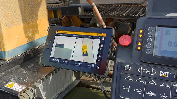
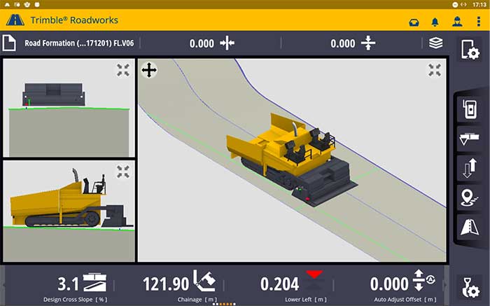
According to the company, Trimble Roadworks is an accurate, automatic 3D screen control system that can improve paving productivity and rideability by directly referencing the design rather than a surface or stringline to minimize asphalt usage, reduce waste and overruns, and finish projects on time and under budget.
The Android-based application runs on the 10-inch touch screen Trimble TD520 display. Operators can personalize the interface to match their workflows, and configurable views make it easier to see the right perspective for maximum productivity, the company said.
The software uses components from Trimble Earthworks, which Trimble says increases the portability of the hardware. Users also can download other third-party applications that provide the operator with additional useful tools inside the cab.
Screenshot: Trimble
“Trimble Roadworks is easy to learn and more accessible for many different types of contractors because it leverages the intuitive Trimble machine control interface and applies it to asphalt pavers,” said Kevin Garcia, general manager for Trimble Civil Construction Specialty Solutions. “This platform also makes it possible to include Trimble’s industry-leading paving technology as part of a connected site ecosystem of solutions, which is valuable for complex infrastructure projects.”
In addition, using a Trimble SNM941 Connected Site Gateway, Trimble Roadworks allows the transfer of 3D designs from the office to the machine via the cloud so that the operator is always using the latest design.
Trimble Roadworks 3D Paving Control Platform for Asphalt Pavers is now available globally through the worldwide SITECH distribution channel.