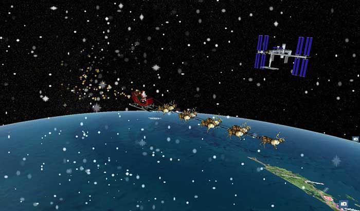
Santa Claus will be performing a ceremonial fly-by of the International Space Station (ISS) on Dec. 24. The visit will honor the 20th anniversary of continuous life on the ISS, a milestone achieved in November.
The official NORAD Santa Tracker at NoradSanta.org will allow users to track Santa’s journey all day on Dec. 24. New for this year, visitors will be able to see the ISS orbiting the planet in its precise real-time location by zooming out on the 3D Santa Tracker app. Other updates include additions to Santa’s traditional garb, including a face mask and space helmet.
Santa’s sleigh flying past the International Space Station on a precise digital twin of the Earth built by Cesium. (Photo: Cesium)
“The ISS is a spectacular example of what humans can accomplish when we work together,” said Hannah Pinkos, lead developer of the app. “2020 has been a tough year, but I think this special trip is Santa’s way of reminding us to believe in ourselves.”
NORAD, the North American Aerospace Defense Command, is a United States and Canada bi-national organization that defends North America by tracking objects flying in and around its airspace 24 hours a day using radar, satellites and fighter jets. Each year, it joins corporate partners in taking on a special mission to also track Santa’s sleigh. The app shows Santa’s position reflected on a digital twin of the Earth provided by Cesium, a Philadelphia-based geospatial software company.
“Cesium is rooted in aerospace, so it’s especially meaningful to us that our technology will allow millions of people to enjoy this event in real-time from the safety of their homes,” added Cesium CEO Patrick Cozzi.
According to a new market research report, “Anti-Jamming Market for GPS with COVID-19 Impact, by Receiver Type (Military and Government Grade and Commercial Transportation Grade), Technique (Nulling, Beam Steering and Civilian), End-User, Application and Geography — Global Forecast to 2025,” the anti-jamming market for GPS is valued at $4 billion in 2020 and is expected to reach $5.9 billion by 2025.
The report, published by MarketsandMarkets, also states that the market is expected to grow at a CAGR of 7.9% from 2020 to 2025. Some of the key factors driving this growth include high demand for GPS technology in military applications and ongoing developments to improve overall GPS structure. Factors such as the growing demand for unmanned airborne vehicles and systems and the development of low-cost GPS anti-jamming solutions also are expected to provide growth opportunities to players in the GPS anti-jamming market.
According to the report, Nulling Technique is expected to hold largest share of GPS anti-jamming market from 2020 to 2025. In addition, surveillance and reconnaissance are expected to hold largest share of GPS anti-jamming market during the forecast period.
The GPS anti-jamming market in Asia Pacific is expected to grow significantly, as a result of a rise in the number of terror attacks in the region, which has led to countries enhancing their surveillance and antiterrorism capabilities, the report added. Countries in this area are also manufacture defense aircraft, which is expected to increase the scope of GPS anti-jamming for defense and aerospace systems. An increase in the defense expenditures of India and China, among other countries, and the expansion of militaries in emerging economies also have accelerated the demand for GPS anti-jamming solutions in Asia Pacific.
Raytheon Technologies, Hexagon, Thales Group, L3Harris Technologies, BAE Systems, Cobham, Mayflower Communications, infinDome, Lockheed Martin, Israel Aerospace Industries, Furuno Electric and Meteksan Defense are few major players in the GPS anti-jamming market.
MarketsandMarkets provides B2B research on 30,000 niche opportunities/threats that will impact 70% to 80% of worldwide companies’ revenues, the research firm said.
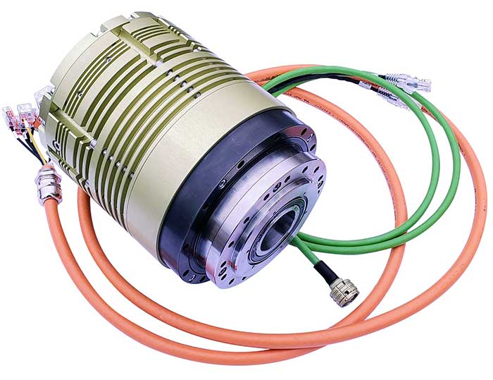
UAVOS has debuted its Xservo-Series Hollow Shaft Servo Actuators, which feature embedded CANopen/EtherCAT servo drive.
The actuators include a built-in motion controller, which allows users to skip the complex stage of mechanical and electrical integration of a passive servo actuator with an external servo drive controller, the company said.
In addition, the actuators, which are encased with rugged, IP65-rated anodized aluminum alloy casing, boast a hollow shaft that makes it easy to pass power supply cables, shafts or laser beams directly through the servo actuator.
According to UAVOS, the actuators are capable of nx360 degree proportional rotation and are ideal for a wide range of rotary applications within UAVs and robotic platforms. New actuators are immune to shock and vibration and designed for use in harsh conditions, the company added.
“This is just the beginning of a series of product releases we are planning for this year, and our customers can be excited about what is about to come,” said Aliaksei Stratsilatau, CEO and lead developer at UAVOS. “Our incentive is to meet most of our customers’ requirements, and this is why we constantly invest in our R&D capacities and keep an ear close to the market.”
UAVOS Xservo-Series are designed to be used in industrial applications where high accuracy, high torque and low weight are essential.
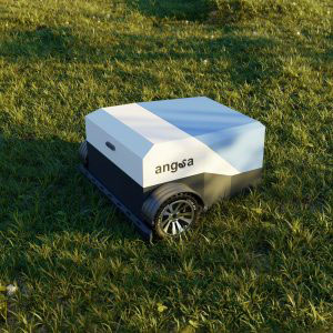
Startup Angsa Robotics was named the overall winner of the Galileo Masters 2020 competition for its autonomous rubbish robot.
According to Angsa Robotics, “Clive” is Germany’s first autonomous rubbish robot. It can move independently and detect and localize individual objects based on its unique artificial neural network architecture, which enables it to clean grass and gravel areas. In addition, individual objects such as crown caps or cigarette butts are targeted for collection, but insects are spared.
The robot’s target use cases include cleaning festival venues after events and the daily cleaning of parks and other green spaces. It can be used where conventional sweeping machines designed for flat asphalt surfaces cannot be used, Angsa Robotics said.
Precise localization via GNSS is essential to its operation, Angsa Robotics added. With better localization, “Clive” can plan a more efficient path and clean a given area faster.
“Angsa Robotics is another concrete example of the innovation and applications that GNSS is enabling for the benefits of business, society and the environment,” said Rodrigo da Costa, executive director of the European GNSS Agency (GSA). “The combination of precise GNSS localization with further state-of-the art techniques such as artificial intelligence and robotics captures in a nutshell the spirit of the three challenges in this year’s edition of Galileo Masters.”
The Galileo Masters’ network of 101 partners from 18 countries focuses on the regional implementation of the competition to ensure a high level of diversity while enhancing both job growth potential and regional development opportunities. At the 2020 Space Awards, seven challenge winners were honored by representatives of the European Commission, GSA, the German Aerospace Center (DLR), and the German Federal Ministry of Transport and Digital Infrastructure.
The Galileo Masters, founded by AZO, DLR and the Bavarian State Ministry of Economic Affairs and Media, Energy and Technology, annually awards the best services, products, and business ideas using satellite navigation in everyday life.
Reef Support, an automatic warning system that uses artificial intelligence (AI) and satellite imagery to detect coral bleaching, algal blooms, sediment plumes and debris caused by humans, won the Copernicus Masters 2020 competition.
The Reef Support team includes Crystle Wee, Yohan Runhaar, Marcel Kempers, Marijn van der Laan and Eilidh Radcliff.
Reef Support addresses both the environmental and economic aspects at hand with state-of-the art technology. Its user-friendly online monitoring and maintenance tool uses AI and satellite imagery to track coastal reef health and also provides guidelines for crowd and pollution control, debris management and coral restoration.
According to the team, different types of data can be combined to form a picture of reef ecology across a wide range of spatial and temporal scales. The Reef Support platform can be used for strategic planning and resource management in aquaculture farming, as well. Its deep learning algorithm adapts to user applications and regional tendencies.
The subscription-based service is available on both iOS and Android.
Celebrating its 10th iteration in 2020, the international innovation competition Copernicus Masters awarded prizes in 22 categories to outstanding products and services based on Earth observation data. In total, 591 participants from 47 countries submitted 220 new Earth observation business cases and application ideas.
“Copernicus Masters has proven to be the perfect instrument to reach entrepreneurs to become a reality in Earth observation and tackle challenges such as climate change, technology revolutions, shifts in geopolitical power or humanitarian crises, and to support economic growth, safety and security, quality of life and sustainable development,” said Jan Wörner, director general at the European Space Agency (ESA).
AZO launched the Copernicus Masters in 2011 on behalf of the ESA.
The conference will feature two tracks: commercial and policy, and research. The commercial and policy tracks include high performance and safety critical applications; status and future trends in GNSS; and mass market and commercial applications. The research tracks include multi sensor and autonomous navigation; algorithms and methods; and advanced GNSS technologies.
The conference will also feature a new competition, the High Precision GNSS Positioning on Smartphones Competition. According to ION, participants will use a pool of GNSS datasets collected from smartphones and accompanied with high accuracy ground truth to achieve the best accuracy with the datasets provided. The winner will be based on the accuracy of the results. Team winners will win a cash prize, the opportunity to present their results during ION GNSS+ 2021 and be recognized during the ION GNSS+ Awards Ceremony, ION added.
RedTail Lidar Systems partnered with an engineering firm to demonstrate the RTL-400 lidar system’s high-resolution, high-accuracy mapping capability.
Cross-section of lidar point cloud (Image: RedTail Lidar Systems)
According to the company, its lidar imagery was used to generate as-built conditions of a steep ravine to aid in long-term monitoring of the slopes under which a natural gas pipeline was buried.
A narrow road traversing the top of the ravine through which the pipeline was installed was of concern since the instability could be dangerous. Loss of vegetation along the buried pipeline’s path also makes the area especially susceptible to slides after heavy rainfall.
Top view of lidar point cloud (Image: RedTail Lidar Systems)
The RTL-400’s high-resolution point cloud data of the 13-acre ravine area was captured in 10 minutes, RedTail Lidar Systems said. The as-built digital elevation model (DEM) created from the lidar point cloud can be compared to future DEMs to determine if any changes have occurred in the slope’s topology, which would serve to identify hazards and provide input for slip mitigation.
RedTail Lidar Systems is a division of 4D Tech Solutions, a company focused on providing innovative technology-based solutions to address government and commercial customer needs.
The Royal Institute of Navigation (RIN) has issued a call for papers for the Navigation 2021 conference.
The conference, which as of now will be held virtually Nov. 15-18, 2021, will bring together experts from industry, research institutions, government agencies and investors whose primary goal is to work together for a more navigable world, RIN said. Conference themes will include PNT systems and technology, robust PNT, PNT applications, animal and human navigation, and navigation in society.
The November 2021 event will unite two established conferences: the International Navigation Conference and the European Navigation Conference.
RIN is accepting papers in the following categories:
Peer-reviewed: Abstracts and, if accepted, papers will be peer reviewed and published to be indexed and searchable. Presentations will be invited in a parallel technical session at the conference.
Presentation: Abstracts will be reviewed and, if accepted, submitters will be invited to present their work in a parallel session at the conference.
Poster: Abstracts will be reviewed and, if accepted, posters will be displayed in the exhibition hall. RIN plans to encourage delegate interaction through poster presentations during the networking sessions.
The best peer-reviewed papers will be invited to submit for consideration to be published in the Journal of Navigation, RIN added.
Navigation 2021 will take place as a virtual conference. According to RIN, it will review the situation in 2021 and if possible run an in-person element to compliment the conference.
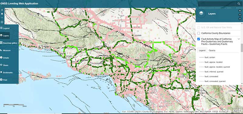
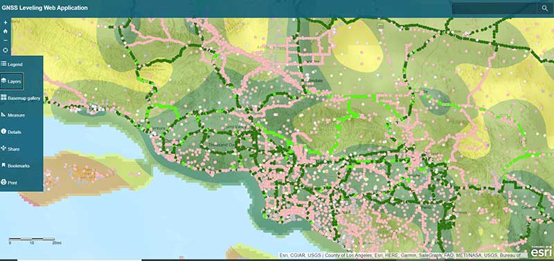
My last column described a new National Geodetic Survey (NGS) webtool for obtaining geodetic information about a passive mark in their database. The column highlighted some features that may be of interest to GNSS users. It provides all of the information about a station in a more user-friendly format. This column highlights an ArcGIS web application that incorporates various California specific datasets and NGS data layers to assist surveyors planning vertical control surveys. The GNSS Leveling Web Application was provided to me by Jay Satalich, chief, Office of Surveys, Caltrans (see box titled “Linkedin Notification from Jay Satalich).
Linkedin Notification from Jay Satalich
Supervising Transportation Survey (Chief, Office of Surveys) at State of California, Department of Transportation:
“GNSS Leveling Web Application” [is] an Esri ArcGIS online web app created for my “GNSS Leveling” students at College of the Canyons. Designed as a practical tool when planning vertical control surveys using GNSS. National datasets include: National Spatial Reference System (layers: satellite visibility, stability, and vertical control source), geology, and GEOID18 (layers: GEOID18 height, difference between GEOID18 and GEOID12B, and GEOID18 uncertainty). California-specific datasets include: oil/gas/fracking/injection wells, fault lines, oil fields, groundwater basins, and landslide areas. The NOAA National Geodetic Survey data layers were created and published by Brian Shaw. People who influenced development of this app include Dave Zilkoski, Kevin M Kelly, Ken Hudnut, David D Jackson, Ross S. Stein, and Arthur Sylvester.
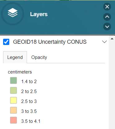
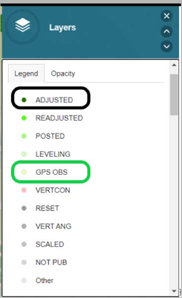
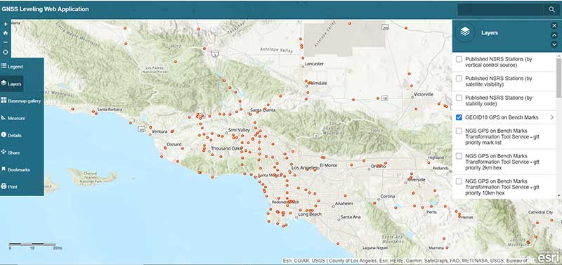
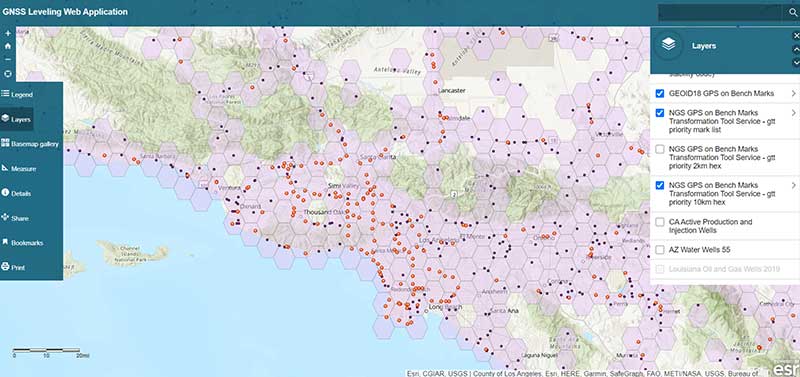
The box titled “GNSS Leveling Web Application” depicts a map of the Los Angeles area that provides the list of published marks in NGS’ database with an overlay of the uncertainty of NGS’ hybrid geoid model GEOID18. Plotting the published marks from NGS’ database is very useful for surveyors reconning marks for a GNSS survey project. The attributes allow users to quickly identify stations that have published heights from leveling adjustments projects (labeled as ADJUSTED) and those that have heights published from GNSS adjustments projects (labeled as GPS OBS). (See here for definition of attributes.)
Source: Esri ArcGIS GNSS Leveling Web ApplicationSource: Esri ArcGIS GNSS Leveling Web Application
Source: Esri ArcGIS GNSS Leveling Web Application
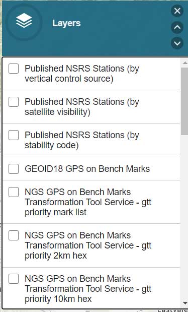
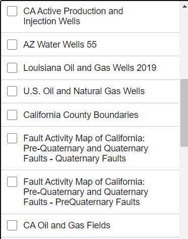
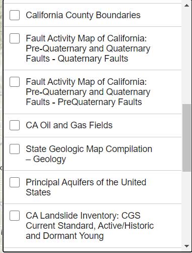
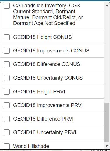
The list all of the layers of the web application are provided in the box titled “GNSS Leveling Web Application Layers.” (Note: After you open up the web application, click on the Layers icon to obtain the list of available layers.)
GNSS Leveling Web Application Layers
Source: Esri ArcGIS GNSS Leveling Web ApplicationSource: Esri ArcGIS GNSS Leveling Web ApplicationSource: Esri ArcGIS GNSS Leveling Web Application
Source: Esri ArcGIS GNSS Leveling Web Application
As you can see from the list of layers, the web application enables users to select the layers that are pertinent to their survey project requirements. The application is designed for California surveyors but the concept is transferable to other States. For example, the following layers are not just for California surveyors: Arizona water wells, Louisiana oil and gas well, U.S. oil and natural gas wells, Principal Aquifers of the United States, and, of course, all of the NOAA NGS data layers.
One layer that is very important to California users is the layer that provides the fault activity in their region. The box titled “Fault Activity Map of California: Pre-Quaternary and Quaternary Faults – Quaternary Faults” depicts the list of published marks in NGS’ database with an overlay of the fault activity map.
Fault Activity Map of California: Pre-Quaternary and Quaternary Faults — Quaternary Faults
Source: Esri ArcGIS GNSS Leveling Web Application
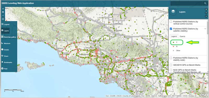
Another great feature of the application is that it has a layer providing the satellite visibility code for published NSRS marks (see the box titled “Published NSRS Stations (by satellite visibility”). Once again, a great feature for field personnel performing reconnaissance.
Published NSRS Stations (by satellite visibility)
Source: Esri ArcGIS GNSS Leveling Web Application
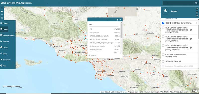
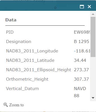
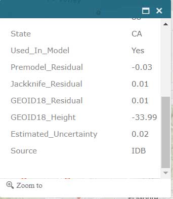
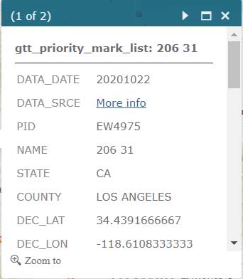
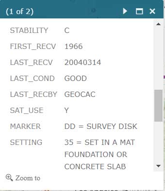
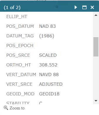
The application also has a feature that lists the marks that were involved in the development of NGS’ hybrid geoid model GEOID18. (see the box titled “GNSS Leveling Web Application GEOID18 GPS on Bench Mark Layer”). Clicking on a mark’s icon provides information and statistics about the mark (see boxes titled “GEOID18 GPS on Bench Mark Layer — PID EW6989” and “Information for GPS on Bench Mark for PID EW6989”). This is one of the layers that provides information for the entire CONUS region. All this information is available from NGS’ website but this application incorporates all of NGS’s data as well as the local information in one application. This web application is very useful to a surveyor planning a survey project and/or providing information to a field reconnaissance team.
GNSS Leveling Web Application GEOID18 GPS on Bench Mark Layer
Source: Esri ArcGIS GNSS Leveling Web Application
GEOID18 GPS on Bench Mark Layer — PID EW6989
Source: Esri ArcGIS GNSS Leveling Web Application
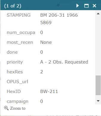
Information for GPS on Bench Mark for PID EW6989
Source: Esri ArcGIS GNSS Leveling Web Application
Source: Esri ArcGIS GNSS Leveling Web Application
Users that are participating in NGS’ GPS on Bench Mark program can click on the layer for “NGS GPS on Bench Marks Transformation Service Tool, priority 10 km hex” to determine marks that need to be occupied by GNSS to improve a transformation tool being developed by NGS. See boxes titled “NGS GPS on Bench Marks Transformation Service Tool, priority 10 km hex” and “Information for GPS on Bench Mark Priority List for PID EW6989.” There’s also layers that depict the priority mark list for the GPS on Bench Marks program (“NGS GPS on Bench Marks Transformation Tool Service — priority mark list”) and the 2 km hexagon priority grid (“NGS GPS on Bench Marks Transformation Tool Service — priority 2km hex”).
NGS GPS on Bench Marks Transformation Service Tool, priority 10 km hex
Source: Esri ArcGIS GNSS Leveling Web Application
Information for GPS on Bench Mark Priority List for PID EW6989
Source: Esri ArcGIS GNSS Leveling Web ApplicationSource: Esri ArcGIS GNSS Leveling Web ApplicationSource: Esri ArcGIS GNSS Leveling Web Application
Source: Esri ArcGIS GNSS Leveling Web Application
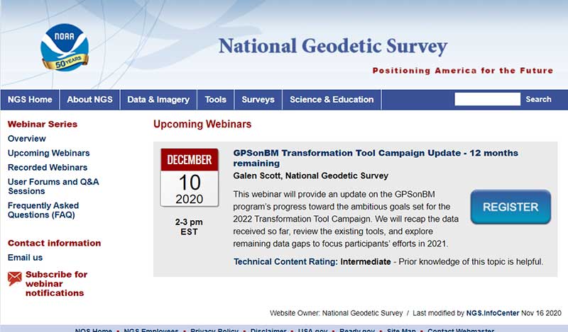
Individuals interested in participating in NGS’ GPS on Bench Mark program should register for NGS’ Dec. 10 webinar, which will discuss the status of the program. See the box titled “GPSonBM Transformation Tool Campaign Update — 12 months remaining” for the information on the webinar. Users can register for the webinar here. I would encourage all users to access the web application tool developed by Jay and/or NGS’ website before participating in the next NGS GPS on Bench Mark webinar.
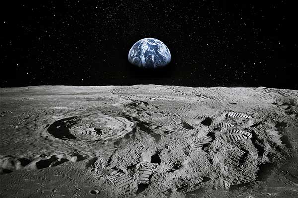
Almost all of my columns have focused on establishing accurate GNSS heights. Most of my 45 years of working in the field of geodesy has been focused on heights; that is, leveling-derived orthometric heights, GNSS-derived orthometric heights, and geoid heights. Gravity is very important to estimating all of these types of heights. Recently, a colleague sent me a video proving Galileo’s famous gravity experiment. It’s an older video (November 2014), but it’s really fascinating. You can see the entire video here. Another individual pointed me toward the same experiment performed on the Moon during the Apollo 15 mission. What’s amazing to me is that over 400 years ago an individual spent time studying the effects of gravity and developing the concept of acceleration due to gravity. I wonder what the world would look like today if Galileo would have just accepted Aristotle’s theory of gravity (which states that objects fall at speed proportional to their mass) and decided to focus on other tasks. Saying that, I am amazed that most geospatial users do not realize the importance of gravity (and physical geodesy) in the development of the geospatial products and services that they use daily; and, how critical it is that more research is required to meet future geospatial needs. The advancements in satellites and computers have enabled geodesy to expand into many different disciplines. Geodetic science and technology now underpin many sciences, large areas of engineering (such as driverless vehicles and drones), navigation, precision agriculture, smart cities, cellular telephones, and location-based services. (See the GPS World First Fix column about the shortage of American geodesists).
When I end one of my presentations, I always emphasize that Geodesy Provides the Foundation for all Geospatial Products and Services, and Integrated and Collaborative Organizations Create Geospatial Solutions. Geodesy is just as important today as it was 400 years ago.
I hope everyone stays safe during this COVID-19 pandemic and enjoys the holidays.
SPH Engineering has partnered with Daewoo Engineering and Construction (E&C). Through the partnership, SPH will support Daewoo’s data management projects through its Atlas artificial intelligence (AI) platform, which enables aerial imagery storage, map creation, change tracking, object detection and territory segmentation.
Photogrammetry data is expected to become one of the key components for storage and processing, SPH added.
According to the companies, Atlas will enable Daewoo Engineering and Construction to set up an online archive of drone imagery and photogrammetry products, track changes and generate reports, automate object detection and measure the identified objects of interest. The platform also will increase data availability for participants of construction workflow.
“Atlas can be definitely used in various fields, but it will be a groundbreaking platform, especially in the field of construction survey,” said Geunmok Song (Alex), digital construction team manager at Daewoo Engineering and Construction.
“When we introduced Atlas back in spring, first of all we wanted to support our existing UgCS customers with an easy-to-use AI tool to store and process data collected with our software integrated to a UAV,” said Alexei Yankelevich, R&D director at SPH Engineering. “We are proud that Daewoo Engineering and Construction, the representative of Korea, has opted for our solution.”
Cobham Aerospace Connectivity has been selected by General Atomics Aeronautical Systems Inc. (GA-ASI) and the U.S. Army to provide the anti-jam GPS systems for the MQ-1C ER Gray Eagle Extended Range (GE-ER) unmanned aircraft system (UAS) platform.
As part of a multi-domain operation equipment suite that is compatible with existing GE-ER aircraft, the DACU-8 capability provides assured positioning, navigation and timing to the Gray Eagle ER UAS, weapons and sensors. According to Cobham, this modification to the Gray Eagle ER UAS ensures the platform can provide reconnaissance, surveillance and target acquisition and attack capability, even in a GPS contested environment.
The digital antenna control unit (DACU) and controlled radiation pattern array antenna system were chosen for their performance in jammed and benign environments, as well as their ability to output direction finding to on-board systems, Cobham said. This direction-finding capability allows the system to perform as a sensor, enabling the platform to identify, locate and respond to the jamming threat.
“GA-ASI and Cobham collaborated very closely on integration activities and on-platform performance evaluations to deliver cutting edge technology for the U.S. Army,” said Matt Cadwell, North America sales director at Cobham. “Cobham is very proud to support GA-ASI’s leadership through the ‘survive, persist and thrive’ evolution in denied environments. The DACU-8 capability ensures GE-ER’s ability to persist in a contested environment, providing critical RSTA capability in a contested environment, supporting the Army, as well as the joint force.”
The U.S. Space-Based Positioning, Navigation and Timing (PNT) Policy tasked the NASA Administrator to develop and provide requirements for the use of GPS and its augmentations to support civil space systems. NASA is exploring the viability and enhancement of GPS and GNSS signals in the Space Service Volume and beyond to support operational U.S. missions and civil space systems. Spirent GNSS solutions and expertise will support testing of the GNSS receivers intended to be deployed in the upcoming lunar exploration, the company said.
“For over two decades, NASA and other space users have selected us to provide leading-edge test and development solutions for missions ranging from short suborbital flights to weeks-long orbits beyond geosynchronous altitudes,” said Ellen Hall, president at Spirent Federal Systems. “Working collaboratively with our customers enables us to meet their demanding test and development needs with the trusted solutions for which Spirent is known.”