Author: Tim Burch

  • Expanded GNSS and 5G: A gift for the surveyor

    Expanded GNSS and 5G: A gift for the surveyor

    Regular readers of GPS World are aware of many of the rapidly developing technologies and navigational systems being created around the world, but often the everyday surveyor shows up late to the party.

    While smartphones get the most mainstream media coverage, other navigational devices and measurement systems are adapting to evolving technical breakthroughs and new methods of transmitting a variety of data wirelessly.

    This month’s article looks at the increase in satellite navigation networks along with the rollout of 5G cellular technology. Both advancements will benefit the surveying community; to start, I’ll explain what this means for accuracy and precision of survey measurements as well as productivity.

    Everybody gets a constellation! (with apologies to Oprah)

    I’ve been known to wax poetic in this column about my admiration of GNSS technology, and I continue to marvel at the “accidental” civilian use of a military tool. This method of measurement and navigation continues to expand, refine and transcend everyday life, and surveying is no exception.

    The satellite constellation is the mainstay of this navigational system. The United States began the charge several decades ago, but other nations are quickly catching up. Let’s look at the current constellations and their status.

    Operational Systems

    • GPS (United States)
    • GLONASS (Russia)
    • Galileo (European Union)
    • Beidou (China)
    • QZSS (Japan)
    • IRNSS (India)
    Chart: GPS World
    Chart: GPS World

    There are now more satellites. What’s the big deal?

    The addition of these constellations provides large gains for the surveying community in several different ways.

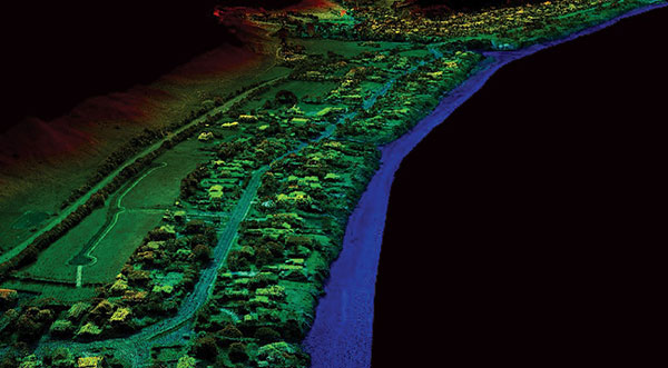
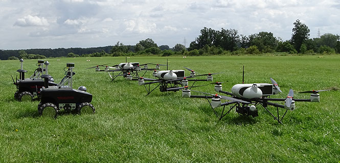
    First, the additional satellites mean more signals to help with the mathematical equations necessary for positional determination. While traditional surveying in the general public’s eye is associated with measurements on the ground, our expansion of services into the air and water relies heavily on GNSS determined positions.

    No matter what type of remote sensing equipment is being used (lidar, photogrammetric, sonar, etc.), positional determination for most of those sensors are derived from GNSS-based receivers. Add to these measuring methods the ability to perform operations via remote-controlled or autonomous vehicles in both air and water, and the availability of additional satellite signals enhances the reliability of GNSS-derived data and attributes.

    Second, by having more satellite signals to utilize, GNSS receiver manufacturers can improve the software for processing the positional information with greater certainty of accuracy.

    Before the introduction of additional constellations and receivers with expanded signal reception, GNSS users relied on less sophisticated software to identify potential “bad” signals that would lead to incorrect positions. While the software generally provided reasonable reliability, it was not foolproof and occasionally would allow bad data to be accepted.

    Like most everything tech-related, however, the GNSS industry has benefited from increased computing power to go along with the additional satellite constellations. The latest GNSS receivers can accept well over 500+ signals from a variety of sources (including land-based transmitters). The software used to reduce all that data has increased in complexity along with number of those data sets.

    Complex computations that were once limited to mini-computers or even mainframes are now being completed on handheld data collectors in minuscule timeframes compared to their predecessors.

    The software has also been enhanced to analyze the data in real-time, compute the likely position of the receiver and notify the user of potential incorrect or “spoofed” data from any number of satellites.

    Considering that many of the remote-sensing sources now collect millions of points based upon one GNSS-based position, the need for increased positional verification has become a critical issue. By having many more constellations to provide signals for positional data, the percentage of establishing a correct location for each data point has increase significantly.

    The improved computing power and verification ability of today’s GNSS software is helping to eliminate errors in positional accuracy and instill more confidence in the surveyor’s data collection activities.

    Add to these additional constellations the planned installation of more land-based signal providers to augment or provide a backup plan for satellite systems, and it’s clear that the future is quite bright for GNSS-based receivers and data collection for everyone — especially the surveying community.

    The history of wireless communication

    While surveyors marvel at the advancements of GNSS-based measurement, it pales in comparison to the rapid growth of modern technology with cellular devices. Notice I didn’t write cellular phones, as the technology has quickly established itself as much more than voice communication. Before we lay out the future of cellular data networks, let’s take a step back and see how this type of communication has revolutionized GNSS-derived data collection for surveyors and others.

    Two-way, CB and shortwave ham radio

    1947 two-way radio advertisement. (Image: Motorola)
    1947 two-way radio advertisement. (Image: Motorola)

    The technology behind wireless communication goes back several decades, but didn’t become a mainstream system until the late 1970s and early 1980s. Motorola is known as the early force behind the two-way radio system, but the base and remote transmitters were not cost effective for small businesses. This type of system was also limited to single-purpose radios with individual crystals wired within that only allowed specific frequencies to be transmitted.

    Another type of communication used by some was the citizens band radio, affectionately referred to as CB radio. This radio was limited to 40 channels and didn’t allow for private transmission between two parties. During the 1970s, the use of the CB radio was not limited to long-haul truck drivers — many people used the medium for basic communication.

    Vintage CB radio ad from Radio Shack. (radioshackcatalogs.com)
    Vintage CB radio ad from Radio Shack. (radioshackcatalogs.com)

    Telephone service during these times was still costly and long-distance calls were not cost-effective, so many found the CB radio as an alternative to conventional phone service. Looking back now, it is not a stretch to classify this type of broadcasting as a primitive social media precursor to today’s methods but limited to live chats and no visuals.

    Another method of transmission was short-wave radio. This system was like two-way radios with an established base transmitter, but broadcast on public frequencies over greater distances than CB radios. One of the big drawbacks was the upfront costs, which were much more significant than the other radios. Even more expensive was outfitting a vehicle with a shortwave system, so cost was the biggest limiting factor for this mode of communication.

    Pagers of all shapes and sizes

    Motorola's Pageboy pager. (Photo: Motorola)
    Motorola’s Pageboy pager. (Photo: Motorola)

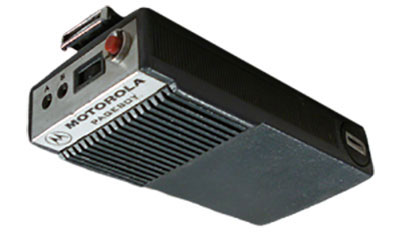
    The popularity of telephone-based pagers didn’t hit its zenith until the early 1990s, but the technology and actual use dates to the early 1960s. The first commercial pager was produced by Motorola in 1964 and called the Pageboy. There was no screen or display; the user was notified by a variety of tones preset for distinct situations or needs. As this technology advanced, variations in screens, message types and even two-way communication became possible.

    By 1994, there were more than 60 million pagers in use, but a change was in the technological wind; cellular phones were marching toward the mainstream.

    Cellphones on every street corner

    Motorola DynaTAC 8000X portable cellular phone, 1984. (Photo: Motorola)
    Motorola DynaTAC 8000X portable cellular phone, 1984. (Photo: Motorola)

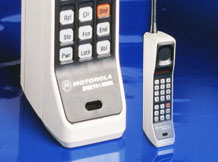
    While the concept of wireless telephone communication existed in several laboratories around the world for years, the first big breakthrough was made by researcher Martin Cooper, who developed a prototype cellular device for Motorola in the early 1970s. He famously made the first public cellular phone call on April 3, 1973, to Joel Engel, head of research at Bell Labs, during a walk in New York City. Cooper and Engel were engaged in a rivalry to develop the first commercially available cellular phone with the Motorola DynaTAC prototype being the first to make a successful call.

    However, the rush to get cellular phones to market took longer than anticipated. It wasn’t until the introduction of the Motorola DynaTAC 8000 in 1983 (available to the public in March 1984) that the reality of wireless phones came to life. The cost of wireless freedom came at a price: $3,500 for a brick-sized phone that took 10 hours to charge for 30 minutes of use. The cost of the service was also expensive due to the limited cellular infrastructure.

    The next decade brought us expanded cellular coverage along with miniaturization of phone; each subsequent model provided more features and longer battery life. From the Nokia “candy bar” to the Motorola Razr, the cellphone era had engulfed the mainstream, but more changes were ahead for mobile communications.

    The late 1990s saw the introduction of the cellphone as a computer modem, with limited email connectivity and primitive internet browsers built into the operating systems. But like many electronic technologies that came before, the cellphone would begin a radically different life in the mid-2000s.

    Enter the smartphone to help us dummies

    The IBM Simon Personal Communicator and charging base. (Photo: IBM/public domain)
    The IBM Simon Personal Communicator and charging base. (Photo: IBM/public domain)

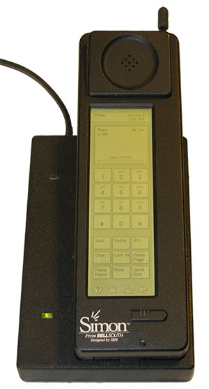
    Officially, the smartphone has been in existence since 1992 with the creation of the Simon Personal Communicator from IBM. At a cost of $1,100, with a monochrome screen that was 4 ½ x 1 ½ inches, the Simon allowed the user access to email and faxes (remember those?) along with the phone function — but users had to make it fast; the battery only lasted an hour. IBM sold 50,000 of these units before pulling the plug on the project, but it started the trend toward mobile telephones with a graphical interface and extended uses beyond the standard verbal communications.

    Just like the Apple Newton was the failed precursor to the Palm Pilot, various tablets and eventually today’s smartphone platform, the Simon broke ground and established new directions for future communication.

    The early 2000s introduced us to the Blackberry personal digital assistant (PDA) and phones from Research in Motion (RIM), a small electronic communications company from Ontario, Canada. RIM started small with a two-way paging system that became popular in Europe and quickly morphed into cellular devices that worked on the DynaTAC network used by Motorola.

    A recent model Blackberry PDA. (Photo: Blackberry)
    A recent model Blackberry PDA. (Photo: Blackberry)

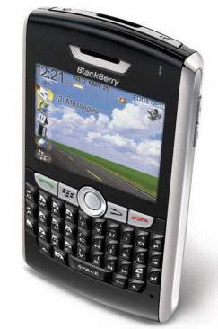
    By the mid 2000s, their devices became affectionately known as the “Crackberry” as users became addicted to the functions and capability of this communication tool. These devices were popular with business users as the security encryption was considered more effective than any of the other communication apparatuses of the day.

    By 2009, Blackberry had reached the zenith of the mobile device market (second only to the conventional mobile-phone platform dominated by Nokia) but began a rapid decline due to proliferation of the next big thing — the touchscreen smartphone.

    After Apple’s introduction of the iPhone in 2007, followed by a crowd of Android-powered phones in 2008 and beyond, Blackberry’s market share has been reduced to a small niche group.

    And now, why this relates to the surveyor…

    The rollout of Steve Job’s dream of combining Apple’s industry-defining iPod with mobile phone capability revolutionized not only the way we communicate — it has redefined our everyday environment. Many of the tasks we accomplish every day have been incorporated into a smartphone application, which brings us back to the reason this article is directed at surveyors: the device that hangs on your belt or rests in your pocket is revolutionizing the way today’s surveyors work.

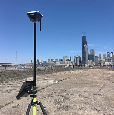
    Not that long ago, the only navigational devices available were large, expensive and difficult to use. Now, nearly everyone owns a device with GNSS capability. When we combine the ever-expanding number of devices along with the increased coverage of GNSS satellite constellations, the ability to georeference any piece of data to greater precision and accuracy is improving.

    Surveyors need to embrace this technology within their smartphones to increase their efficiencies. At the same time, we need to help educate the public on why having better smartphone location capability doesn’t mean the masses can perform their own boundary analyses. For more information on this subject, see the GPS World July 2017 article.

    Surveyors should embrace the smartphone as an important tool; the introduction of new survey-grade GNSS receivers that use an app for the user interface will soon become commonplace.

    Several GNSS manufacturers have introduced receivers that exclusively use a smartphone and app for data collection, eliminating the need for a dedicated (and usually proprietary) data collector for obtaining centimeter-level location data. I’m not advocating that the surveying community throw their existing systems in the trash in favor of these newer receivers, but the data-collection techniques utilized by smartphones can increase efficiency and reduce equipment costs.

    The Mi 8 smartphone offers dual-frequency capability. (Image: Xiaomi)
    The Mi 8 smartphone offers dual-frequency capability. (Image: Xiaomi)

    Another reason to pay attention to the smartphone as a location tool will be the expanded use of dual-frequency chipsets to provide even higher accuracies. One of the fastest growing phone makers worldwide is Xiaomi, based in Beijing, China, which introduced the Mi 8 phone with a dual-frequency GNSS chip. This chip frequency reception (E1/L1+E5/L5) is targeted to embrace the Galileo and GPS constellations for increased accuracies (within a decimeter),  well beyond the current norm for smartphones (typically 1-3 meters, plus or minus). For the surveyor, having this capability in their pocket can greatly increase efficiencies, especially when used during reconnaissance efforts. I believe many more phone manufacturers will begin to incorporate dual-frequency chips in their future models to increase location accuracies for users and take advantage of upcoming network enhancements.

    Speaking of network enhancements, let’s talk 5G as a gamechanger.

    The latest buzz in the general population’s lexicon is 5G and how it will push high-speed internet to all corners of the world. While this is a possibility, it means much more to the surveyor than meets the eye. Yes, there will be increased cellular coverage in places that previously lacked it, or only had limited access, but 5G means much more than that.

    Image: NTT DOCOMO Inc. 5G white paper.
    Image: NTT DOCOMO Inc. 5G white paper.

    Let’s refresh our view of what cellphone coverage currently means to the surveyor. The use of cellular-based RTK receivers has been greatly expanded due to the increased coverage of 4G LTE signals throughout the world, but it’s still scarce is some parts. This is mostly due to the transmission of cellular signals being required from towers and higher placed antennas with powerful transmitters. These transmitters are costly and typically owned and installed by the larger telecom companies, so placement is traditionally in more populated areas.

    Enter 5G — while it will provide enhancements for all users, it will be revolutionary for the surveyor. 4G cell coverage was a broad and powerful signal from large transmitters; 5G cellular service consists of smaller cell signals placed in a tight grid of broadcast positions. These transmitters will be more cost effective for many telecom providers and will increase data reception for many users. For surveyors, the additional coverage of 5G will make possible the use of cellular-based RTK GNSS data collection in places not previously possible.

    Besides the extended coverage of 5G, the 10-fold speed of the new data transmission protocol compared old 4G LTE creates many possibilities for information collection growth. Soon it will be possible for a field personnel and the office staff to be linked in real time during the data collection process.

    From boundary-point recovery to complex topographic surveys, a field crew’s work can be supervised and reviewed while being completed, allowing for instantaneous analysis and guidance from senior staff. This process will allow for more oversight, quality control and mentoring of field staff than is possible for today’s remote crew operations. The new technology will also allow for reduced timeframes when crews are required to provide field data for tight deadline requests and gives us a method of instant feedback on the amount and quality of the data collection.

    Some may see this improvement in connectivity as an avenue for office staff to be intrusive on their field activities, but I see this as an opportunity for improved quality control and increased team interaction. More connected teams can lead to improved efficiencies and overall increases in productivity, profitability and morale among team members.

    From outside to inside

    Another breakthrough created by 5G will be the enhancement of indoor georeferenced location services. By having several transmitters placed throughout a facility, trilateration will be possible to provide more accurate location information for places not typically available to surveyors.

    Depending on the accuracy needed and placement of the cell providers, it will possible for surveyors to use devices designed for remote sensing (laser scanners, lidar, SLAM, etc.) and collect georeferenced data with greater accuracy in relation to a known coordinate system. This by-product will also aid rescue and medical providers during emergencies to help pinpoint individuals through their cellphone connection more accurately than before.

    5G is more than just bringing YouTube videos to your phone faster; it will improve the data collection process of all shapes and sizes. Surveyors will not get left out, but we will need to be ready to take advantage when it comes online. For more on the 5G revolution, see the GPS World February 2018 article on this topic.

    As surveyors, just when we think that technology can’t take us further, we blink and change happens. Moore’s law stated (depending on which revision) that technology would double the number of transistors every one to two years. While some may say that technology is making Moore’s law obsolete, I believe the creativity being used to invent new processes based upon the technology is holding strong.

    I, for one, look forward to many more enhancements to follow in the coming years. Surveyors be ready; the future is here.

  • GPS World report: Survey sector favors multi-GNSS

    GPS World report: Survey sector favors multi-GNSS

    Health compares favorably with rest of industry

    2018 State of the GNSS Industry survey respondents who identified themselves as from the survey sector constituted 30% of the total, corresponding to the percentage of the magazine’s readership.

    What is the most promising and practical way to gain the increased accuracy that survey and other high-precision applications continue to demand? (Source: GPS World 2018 State of the Industry survey)
    What is the most promising and practical way to gain the increased accuracy that survey and other high-precision applications continue to demand? (Source: GPS World 2018 State of the Industry survey)

    Higher Accuracy. Regarding the most promising technology to get the increased accuracy that surveying continues to demand, the outright choice was “dual-frequency, dual- or multi-constellation GNSS,” with “real-time kinematic” coming in second. Surprisingly, the newest technology to be introduced to GNSS receivers, inertial correction, lagged at just over 5%.

    Inertial correction devices, which contain gyroscope and accelerometer technology, are now being installed in survey-grade receivers to increase accuracy and productivity. It’s a gamechanger in GNSS data collection for surveyors, so I am surprised by the survey results. These sensors work in conjunction with the receiver to more accurately collect positional information in relation to the point being acquired. While RTK positions are normally collected at 1-20 Hz, the inertial device works in tandem to further refine a more accurate location. As this technology becomes more publicized in phones and other devices, the surveying community will begin to take notice.

    What role will drones (UAVs) play during the next three years in the survey sector? (Source: GPS World 2018 State of the Industry survey)
    What role will drones (UAVs) play during the next three years in the survey sector? (Source: GPS World 2018 State of the Industry survey)

    Drones. Concerning the role that drones (UAVs) will play in the next three years, by a slim margin — 47% to 42% — respondents state that up to 20% of their work will be completed by UAVs vs. those who feel less than 10% of their work will be done by a drone. Only1.3% answered that UAVs will take over most of their work and displace surveyors in the field for specific survey tasks.

    I see UAVs becoming a standard equipment much like the EDM/total station and GNSS receivers, as it is clearly a unique tool for not just collecting visual images but as a remote sensing device. While it won’t replace workers in the field, it will allow crews to become more efficient, tech-savvy and valuable for human-only types of data collection.

    Business. A whopping 85% of the survey sector found this market either “very healthy, with strong growth” (37%) or “relatively healthy, with moderate growth” (48%). This compares with total of 79% across all GNSS industry sectors. So we’re on top! That is, we are doing comparatively well amid the rest of the GNSS industry — which itself is in very good shape indeed.

    Poll results reflect the positive nature of the surveying profession in relation to technology, specifically GNSS and the utilization of UAVs, in our every day work. Previously, introduction of new technology has been historically unreliable, less than user-friendly, and expensive. The trend with newer technologies, however, has been quite the opposite with shorter, easier learning curves and lower cost of entry. These factors have led more surveyors to upgrade their equipment, implementing newer technologies and thus creating more efficiency in the profession.


    For more results from the 2018 State of the GNSS Industry, see this page.


    TIM BURCH is a professional land surveyor and secretary, Board of Directors, National Society of Professional Surveyors.

  • J-Mate combines GNSS/terrestrial for accuracy

    J-Mate combines GNSS/terrestrial for accuracy

    Javad GNSS has taken the power of its Triumph system and expanded to ground-based measurement technologies (versus satellite-based positioning) with the J-Mate.

    The J-Mate is a new measurement module that combines conventional measurement via laser scanning and photographic imagery with the multi-constellation location accuracy of the Triumph-LS receiver.

    Unlike most conventional total stations, J-Mate does not contain optics for manual use. It does, however, utilize precision horizontal and vertical encoders for angular measurement while the high-definition camera and laser module combine to locate the USB-powered target for accurate measurements, the company said.

    The target rest on top of the receiver and lights up for better visibility to the camera and sensor. The lighting power comes through the USB cord connected to the receiver.

    Coupled with the onboard data collector screen of the Triumph-LS, operation of the module is done visually with the LS mounted on top of the module or remotely on the J-Pod pole used for GNSS data collection.

    Setup of the module for survey data collection can be accomplished by several different methods: Backsight, Resect or Astro-Seek.

    The Backsight method of station establishment, while following in the manner of traditional total stations, can be accomplished by several different methods utilizing the J-Mate and Triumph-LS.

    • The first option is to occupy a known station with pre-established horizontal and vertical values, and then proceed to orient the instrument to another known station.
    • The second option is using the Triumph-LS GNSS engines to establish a station coordinate value, perform the same procedure on the reference station, and use the J-Mate software to calculate backsight azimuth for orientation.
    • The last option is to use a combination of the known coordinates or collect GNSS-derived values for either station or backsight point and complete the station setup.

    The Resect method is utilized when occupied station cannot use GNSS-observed coordinate values but can view two or more stations with known values. Once the user has measured all the visible know stations, the data-collection software provides geometric precision analysis and a coordinate solution if tolerances are acceptable.

    The last method of orientation, Astro-Seek, can observe solar or lunar positions to accurately determine the location and orientation of the station. The user installs a darkening filter for solar observations and starts the Astro-Seek process; the module automatically makes necessary remaining measurements and calculations.

    J-Mate screen (Image: Javad GNSS)
    J-Mate screen (Image: Javad GNSS)

    The J-Mate system is equipped with system parameters that allows the user to customize a variety of settings, including minimum and maximum collection distance, windowing of project area, and edge definition tolerance to fine tune scanning small objects. Also definable within the window area is the scan spacing variable, used to minimize the number of data points where needed.

    According to Javad GNSS, the range of the J-Mate is rated at 100 meters (328 U.S. survey feet) using the Javad target and to most white surfaces, while the rating for darker surfaces is 50 meters (164 U.S. survey feet). Three precision vials are placed around the top for visual verification of levelness in addition to the electronic leveling mechanism, giving the user on-the-fly notification of any unstableness of the instrument.

    The J-Mate isn’t exclusively a data collection system, though; this module and software is also designed to be an efficient staking application. Taking advantage of robust servos and effective targeting system, this system performs dutifully for staking applications where accuracy and precision are required.

  • The surveyor’s role when natural disaster strikes

    The surveyor’s role when natural disaster strikes

    No, this is not a drill or a major motion picture event.

    During my lifetime, many natural disasters that have taken place around the globe. These unfortunate events have created mass destruction and caused many deaths by a variety of environmental elements, ranging from earthquakes and volcanic eruptions to hurricanes and snowstorms.

    Disasters in the United States. (Image: FEMA)
    Disasters in the United States. (Image: FEMA)

    Once Mother Nature decides to unleash her wrath, rarely anything stands in her way. Some types of disasters create situations worse than others, but all have a reputation of leaving a trail of death and destruction.

    Search and rescue is the first and foremost priority when it comes to these disasters, with cleanup and rebuilding to soon follow.

    The role of the land surveyor, however, doesn’t usually enter the discussion when it comes to these situations. It has always been considered an occupation that fills an important role in development, construction and parcel ownership, but rarely is discussed in the same terms as a fireman, policeman or doctor.

    We will take a closer examination at how the surveyor uses skills developed through education, technical training and practical application of geographical data to quietly assist those in need through these difficult bouts with Mother Nature.

    First, however, we will discuss various types of the deadliest natural disasters, the amount of destruction that has been caused and types of problems (besides deaths) that were left because of these tragedies.

    Disasters throughout history

    When describing natural disasters, the obvious ones come to mind: earthquake, hurricane/typhoon/cyclone, tornado, wildfire, flooding/monsoon, drought/famine, volcanic eruption, tsunami, sandstorm, avalanche, and snowstorm.

    All of these have wreaked havoc on mankind for centuries, with more physical destruction taking place in the past few centuries.

    Some of the factors leading to an increase in this devastation are gains overall population and amount of buildings and improvements in populated areas. Let’s look at how each disaster impacts the areas in which it occurs:

    Flooding/Monsoon

    Historically the deadliest type of natural disaster, rainfall through storms and monsoons cause flood events that have caused millions of deaths in several instances around the world. Most of the deaths caused by flooding situations are due to drowning in floodwaters that inundate areas not normally affected by normal amounts of rain.

    The largest flood in recorded history took place in China during 1931, combining melting snow and ice with ongoing rain events to create a continuous flooding event that lasted most of the year. Death toll estimates range from 400,000 to almost 4 million, as many of the victims either died or moved to other regions with no trace.

    Hurricane/Typhoon/Cyclone

    This is another type of flooding disaster, but it combines large amounts of rain gathered from ocean storms with high winds to batter shoreline and inland areas. These storms can often stall in place, causing significant damage by both wind and rain.

    Tornado

    Most weather systems associated with creating tornadoes are believed to occur in the United States, but they happen all over the world. Many of the deadliest tornadoes have taken place in the Middle East, including Bangladesh, Russia and Pakistan. These storms can include torrential rain, but most of the damage caused by tornadoes is wind-related.

    Earthquake

    Shifting tectonic plates and earth-shaking tremors are a significant cause of damage and deaths throughout the world. Most of the highest death tolls have taken place in Asia, with the biggest loss of life occurring in Shaanxi, China, on Jan. 23, 1556, with more than 830,000 deaths.

    Indian Ocean (Jan. 2, 2005): A village near the coast of Sumatra lays in ruin after the Tsunami that struck South East Asia. (Photo: U.S. Navy/Photographer's Mate 2nd Class Philip A. McDaniel)
    Indian Ocean (Jan. 2, 2005): A village near the coast of Sumatra lays in ruin after the Tsunami that struck South East Asia. (Photo: U.S. Navy/Photographer’s Mate 2nd Class Philip A. McDaniel)

    Tsunami

    Often a secondary disaster generally associated with earthquakes in coastal areas, tsunamis kill thousands by inundating shorelines with huge waves and sending vast amounts of water into low-lying areas and poorly constructed seaside villages. The largest tsunami in recent memory was on Dec. 26, 2004, in the Indian Ocean off the coast of Indonesia, with the death toll reaching 280,000 people.

    Volcano

    The biggest cause of earthquakes is typically molten lava expanding to shift tectonic plates, but volcanoes are formed with the lava and associated gases finding an escape in the Earth’s crust.

    Once a volcano has formed, an eruption can lead to significant damage from lava flow onto adjacent land and hot ash spewed into the atmosphere. Many volcanic eruptions throughout history have buried local cities and villages, making them virtually disappear.

    Wildfire

    Grabbing the headlines more recently has been the proliferation of wildfires. While not causing the substantial loss-of-life associated with many other natural disasters, wildfires are responsible for scorching hundreds of thousands of acres of forest and brush areas, as well as decimating neighborhoods.

    Avalanche

    This disaster only takes place in locations with significant snow pack and elevation changes. After large amounts of snowfall, various factors lead to movement of large areas of snow and ice down mountainous slopes. Often these events take place near cities and villages in mountainous regions and can leave the inhabitants buried and unreachable.

    Other Types of Natural Disasters

    While the varieties of events listed above can create large-scale destruction, there are others that, while smaller in nature, can collectively cause great damage and loss of life. Thunderstorms, snowstorms and sandstorms are wind-related and can be devastating to the areas being affected.

    Other natural disasters that often don’t get the same recognition as those listed above include drought and famine. These environmental tragedies ruin thousands of lives, and it take years to recover from the damage caused by these inflictions.

    Disaster hits. Now what?

    June 28, 2008: A house in Parkersburg, Iowa, is being rebuilt while debris from a deadly EF5 tornado still covers the ground. (Photo: FEMA/Richard O’Reilly)
    June 28, 2008: A house in Parkersburg, Iowa, is being rebuilt while debris from a deadly EF5 tornado still covers the ground. (Photo: FEMA/Richard O’Reilly)

    All of these disaster types have led to a great number of fatalities and total devastation of cities and roadways. To help us understand what type of assistance the surveyor can provide, we first need to identify the conditions left by each of these events.

    Most of the disasters simply wipe out whatever is in its path; from tornadoes, hurricanes, and wildfires to earthquakes, avalanches and tsunamis, the regions affected are left in shambles after the occurrence.

    The initial search and rescue through the rubble takes manpower and careful identification of areas where people are known to inhabit, either as residences, places of employment or public spaces. These areas require retracement of existing mapping and atlases to accurately identify those places for timely recovery.

    Once the search-and-rescue efforts have ceased and cleanup/rebuilding commences, the destroyed areas will need to be remapped based upon existing parcels and ownership rights. Reconciliation of existing parcels, subdivisions and rights-of-way will be required to properly return the injured areas to a habitable state.

    The one disaster that’s a big wildcard, however, is the earthquake. The devastation is like the others and generally will need rebuilding like the others, but with one large difference; putting everything back where it belongs.

    When large tremors cause significant shifts in inhabited and/or complex parcels, the ability to retrace existing parcels, subdivisions and rights-of-way to place them in their original location becomes a nightmare.

    How surveyors and GNSS help before and after disasters

    As expert measurers and establishers of boundaries, the surveyor provides guidance for the creation of parcels and rights-of-way. Through extensive education, training and experience, the surveyor combines field reconnaissance, legal definitions of parcels and high-level mathematics to provide direction for the creation and retracement of real property.

    After experiencing a devastating event like the ones described above, the surveyor becomes a key position in rebuilding the affected area.

    Prior to the invention and proliferation of GNSS technology, however, the use of state plane coordinate data was a tedious and time-consuming task (see my January 2017 article at GPS World).

    Establishing coordinate values across a large region and/or utility system was not practical from a time or cost viewpoint. The arrival of GNSS technology in the 1990s changed that situation with the ability to determine coordinate values in real-time and create large databases of infrastructure and utility information. Government agencies (and surveyors) now could replicate, with acceptable accuracy and precision, locations of improvements and utilities throughout their jurisdiction.

    2015 Fairdale, Illinois, tornado recovery. (Photo: NIU Today)
    2015 Fairdale, Illinois, tornado recovery. (Photo: NIU Today)

    Surveyors are now being called upon to assist with search and rescue efforts when these disasters hit to help locate and turn off existing utilities (i.e. electricity, gas, water), and to provide mapping assistance for retracing where people may be in the rubble. Because lives are at stake, timely location is essential for these services and GNSS technology use by the surveyor provides a much-needed service.

    Once these disaster events being a rebuilding mode, the surveyor steps in to find the existing parcel and right-of-way lines to assist the respective owners where a deed or roadway was previously located. Most times, the surveyor can retrace existing line by locating buried monuments and recreating existing deed descriptions and/or roadway locations.

    Where there becomes a problem is when the devastation is large enough to destroy all existing monuments and leave no trace of any occupied land. The surveyor must expand the search area, as far as needed, to find the closest available monuments in which to begin rebuilding the parcel descriptions.

    Depending on the site conditions, GNSS equipment is used to locate the positions of the nearest monuments so the surveyor can perform retracement calculations for the disturbed area.

    Once the area to be re-established to calculated, the surveyor can return to the site and place markers signifying parcels and rights-of-way for the rebuilding of roads, utilities and buildings. GNSS receivers are again utilized to increase the proficiency of the field crew by allowing the installation of the markers over a large area in a short amount of time.

    How surveyors can prepare for future events

    Image: DuPage County, Illinois, GIS
    Image: DuPage County, Illinois, GIS

    As previously written in my January 2017 column, GNSS technology has helped expand geographic information systems (GIS) into a database beast, containing everything from voter districts, zoning regions and floodplain maps to locations of most municipal utility maps and databases.

    When these databases have included a geodetic layer of survey information overseen by the licensed land surveyor, the GIS is now more than a glorified digital Etch-A-Sketch. These entities within the database have geolocation as part of its dataset, with varying accuracy depending on the source of the data.

    By having all this information available in a digital format, typically saved in a cloud-computing location, the ability to replicate these entities becomes a simple exercise. As more information becomes available, it needs to be included into the database for future mapping consideration.

    All relevant data, together with a geolocation tag, becomes valuable for future retracement. This information could be used to locate possible survivors during a disaster event.

    Upcoming technology to assist surveyors with disaster relief planning

    Image: Esri
    Image: Esri

    Many of the tools being utilized by surveyors have the capability of helping with mapping and data collection of municipal and public facilities for GIS database inclusion.

    We currently use laser and lidar scanners both terrestrially and aerially to collect point-cloud data for establishing existing conditions of various sites. This point cloud, along with high-resolution photography, can be used to augment and enhance new and existing GIS databases with extensive datasets.

    By having this additional information collected and available digitally, qualified experts can perform disaster simulation tests to depict various environmental events and determine what strategies will be necessary for search-and-rescue efforts.

    These experts can also use this data to predict potential flood paths, conduct seismic modeling to determine building shift, and combine weather conditions with conceivable wildfire-capable areas. All these potential life-saving exercises can utilize the surveyor as a significant data-collection source.

    Coming to a theater near you…

    Whether one believes in climate change or just being affected by an active environmental cycle of natural disasters, the entire world is prone to have an occurrence of at least one of these events.

    Since these events are not going away, remember to help your fellow man, woman or child in their time of need. It is the duty of the surveyor to provide a service that is intended to protect the public, and being there for disaster planning, prevention and recovery is part of our mission.

    Think of us like the Avengers; now there’s a sequel I’d pay to see.

  • The surveyor and artificial intelligence: A look ahead

    In the not-too-distant future, the following scenario may take place.

    Image: Stockvault
    Image: Stockvault

    A corporation owns an improved property in a large metropolitan city and has decided to sell it to a prospective buyer. Through a series of electronic messages and high-tech operations, the seller, buyer, their respective counsels, lending institutions and a title company are provided with documentation stating the condition of the site along with holograms and 3D digital models worthy of a science-fiction movie. In a matter of minutes, the deal is closed with monies and titles silently swapping places out in the ether.

    Behind the scenes, the surveyor is a big part of this transaction. But how will the operation of the land title survey look in the future? Like everything else, artificial intelligence (A.I.) and blockchain technology will play a substantial role in surveying. I don’t profess to be the next Carnac the Magnificent, but it could look like this…

    HOW IT ALL STARTS

    The seller contacts their corporate attorneys to begin the contractual process. Requirements for the sale include acceptable and insurable conditions of the site and a clean title policy from a title insurance company, so the latest land title survey requirements will be held for site and title review. Once the seller and buyer are committed to a sale of the subject property, a blockchain is established in a transactional database to track every step of the sale.

    Image: GSA
    Image: GSA

    The attorney will consult with “Sheldon,” an artificial intelligence system built by a leading e-commerce company and designed to assist with business-to-business commerce. Sheldon will be used to secure the services of a land surveyor for the transaction. By researching available consultants based upon the information for the parcel contained within the blockchain, Sheldon contacts firms that could meet the criteria for this part of the transaction.

    Once an appropriate firm is chosen by Sheldon, the data for the survey within the blockchain is uploaded to “Thomas,” a digital assistant designed specifically for surveyors. Thomas works with Sheldon and the blockchain to formalize an agreement, secure the necessary insurance requirements, and finalize a payment schedule for services.

    ENTER THE SURVEYOR

    Once the project is secured, Thomas creates a project file, downloads current satellite images, GIS data (including parcel, building and utility information), and recorded documents for the subject parcel. Among the information is parcel data for the project site. This data is based upon historical land surveys and converted into an accurate dataset in which most of the property and land corners are now included in the GIS database. All corners within the database have been installed or upgraded to contain an RFID chip imbedded within the top of the marker.

    Image: NOAA
    Image: NOAA

    These GIS databases also take advantage of ongoing advancements of the North American Terrestrial Reference Frame of 2022 (NATRF2022). Beyond the initial implementation, the National Geodetic Survey has incorporated additional precision gained by improved L5 satellite reception and other nations’ satellite constellations in sub-centimeter location with most survey-grade receivers. Thomas compiles all site data into a comprehensive package for submission to the surveyor.

    Because of the advancements with instrumentation and sensors in locating improvements both above and below the surface of the ground, the latest land title survey standard has moved all optional Table A items into required information to be provided on the plat. The standard also now requires a drainage analysis to be prepared to determine how the subject property relates to the adjacent parcels.

    Thomas reviews the current backlog of project managers and assigns/transmits the project to the first available team. The chosen survey project manager receives the project information and creates an Ethereum blockchain file to work with the master blockchain and begin the survey process. By creating additional survey programming working in conjunction with the project blockchain, all parties involved in the transaction can monitor progress every step of the way.

    The first responsibility of the survey PM is to work with Thomas to evaluate the existing data available for the project location. Current conditions from satellite imagery, improvement and utility information from existing governmental GIS databases, and parcel/easement information from recorded document sources are used to determine flight paths for UAVs utilizing multiple sensors, avoiding substantial obstacles. This process will also establish areas to be surveyed/verified by mobile methods where aerial data cannot be obtained.

    All available information is processed by Thomas to establish the most efficient routes and methods of data collection for the parcel through software designed to compile and review spatial datasets. This software is specifically designed to review existing information for potential conflicts in flight and on-the-ground obstacles. Once completed, a flight plan for the UAV and route plan for the autonomous mobile vehicle will be reported with missed areas identified for manual data collection.

    FIELD WORK ON STEROIDS

    When the time arrives for field work to begin, a technician is dispatched in an autonomous electric truck pre-programmed to go directly to the site. The truck is loaded with various survey-grade instruments and equipment (all GNSS equipped): vertical take-off fixed wing and multi-rotor UAVs (both with lidar, photo, hyper-spectral, and GPR sensors), an autonomous mobile ground robot (with GPR/lidar sensors), and an RFID reader for boundary location.

    The technician works with the equipment through a universal tablet computer controlling both aerial and ground data collection simultaneously, depicting the progress of the work in real time. This gives the technician time to locate the boundary points with the handheld GNSS receiver/RFID reader to verify the limits of the property.

    Once the autonomous work is finished, the technician processes the data on site, and software compares collection coverage versus the initial site review. When processing is complete, the technician will utilize a handheld GNSS receiver with lidar sensor to obtain remote areas not collected by the other methods.

    The remaining data is compiled with autonomous data and re-analyzed for overall coverage and approved by the software for completeness. Once the computer determines everything has been collected, the technician checks the complete box and leaves the site.

    OFFICE WORK AND WRAP-UP

    The final field data is uploaded to cloud servers as the technician leaves the site and the survey PM is notified by electronic message of the field task completion. Thomas, the digital surveying assistant, takes the lead and begins the final processing. The data is reviewed for completeness, parsed for any anomalies within the downloads, and compiled into one database for building a 3D model of the site.

    Photo and lidar data are compared for accuracy, utilities are verified against existing records and easements, and building characteristics are matched against governmental records for zoning code compliance.


    Once this analysis is complete, the final drafting takes place to create the final deliverable. While the data within the model contains attributes of each entity, labels are placed interactively throughout the site to help depict the site information. This model is also suitable for use by architects and planners to utilize in their B.I.M. design programs, so the quality in the modeling output is top notch.

    The final deliverable contains an overall report documenting site conditions, drainage characteristics and physical conditions of various entities. This report will also detail potential site encroachments, possible drainage issues, and zoning/parking red flags. Thomas will report back to the survey PM that all final checks have been made and deliverables made for submittal to the client, leaving only the final transmittal left to do.

    Once the deliverable is received by the client, Sheldon (the B2B automated assistant) recognizes the delivery and begins the process of payment to the surveyor. With standardized surveys, automated assistant/analyzation systems, and trackable processes through blockchain, the client gets a quality product at a market rate in an acceptable timeframe and the surveyor gets paid in a reasonable period.

    THEN WE ALL WOKE UP TO REALITY…

    Maybe this fictional situation for land surveyors won’t be a reality in my lifetime, but I’m not willing to bet against it. I look back at my short 30+ year career and still marvel at the technological advancements yet I acknowledge we are still turning a corner in computing power (see May’s column). I remember the introduction of laser scanners and lidar sensors as future data-collector saviors, gathering multitudes of precise and accurate data much faster than any mortal. Now we have UAVs that can soar above us with little interference and provide images and data at a reasonable cost, so technology does benefit us.

    But what about data that is automated to the point it is beyond the control of the surveyor? And what does this do to our shrinking surveying workforce?

    Some may say it is a godsend on both accounts. I personally won’t turn out a product or survey in which I don’t have a good understanding of what the data represents or how it was collected; that violates a code of ethics of practicing beyond my expertise. I also don’t think automation will eliminate our technicians, but the surveying profession will need to provide adequate training for our next generation.

    “I’M SORRY, DAVE. I’M AFRAID I CAN’T DO THAT.”

    We live in a world in which so many things are automated (Alexa, Siri and “Hey, Google”) to assist us with even the most mundane of tasks. Amazon recently introduced a store where the customer doesn’t stop at a cashier; just grab the items off the shelf and walk out. Apple introduced its latest iPhone that opens by recognizing your face. Automation is here to stay, whether we like it or not.

    Image: MGM
    Image: MGM

    An article by the Pew Research Center (“Automation is Everyday Life“) described in detail the amount of anxiety that automation instilled in Americans. Many felt that while there are opportunities to increase productivity and profitability in many sectors, that will be offset by lost jobs replaced by automation. Others were also troubled by automation becoming more prevalent in medical treatment of senior citizens.

    For many, the thought of automation isn’t nearly as scary as the concept of “artificial intelligence.” While most of the processes involve machine learning (ML) and refining results based upon increasing datasets, computing power is increasing and introducing new methods including “deep learning.” The algorithms being produced by deep learning through neural networks are making smarter decisions as they use larger and more complicated datasets.

    From a June article for The Atlantic, Henry Kissinger (yes, that Henry Kissinger) offered these thoughts on A.I.:

    Henry Kissinger (Photo: The Atlantic)
    Henry Kissinger (Photo: The Atlantic)

    Ultimately, the term artificial intelligence may be a misnomer. To be sure, these machines can solve complex, seemingly abstract problems that had previously yielded only to human cognition. But what they do uniquely is not thinking as heretofore conceived and experienced. Rather, it is unprecedented memorization and computation. Because of its inherent superiority in these fields, AI is likely to win any game assigned to it. But for our purposes as humans, the games are not only about winning; they are about thinking. By treating a mathematical process as if it were a thought process, and either trying to mimic that process ourselves or merely accepting the results, we are in danger of losing the capacity that has been the essence of human cognition. (June 2018)

    He also makes a strong statement that the United States needs to develop a national vision for AI like other countries (i.e. China, Russia, India) to stay competitive in computing power.

    TRANSLATING ARTIFICIAL INTELLIGENCE INTO SURVEYING

    The point of this discussion wasn’t to be “doom and gloom” of technology. I look forward to enjoying many of the advancements of AI and blockchain advancements. Many of the advantages of both technologies have not been brought to the surveying forefront yet, but it will only be a matter of time.

    My one big fear to automation attempting to overtake and regulate some functions of surveying leads back to boundary determination and the increasing use of holding technology/mathematics over monumentation, hence Kissinger’s comment regarding human cognition. The rules of construction will always hold true in my boundary analysis until there is a time and place where all parcels (original and retracement) are created in a mathematical vacuum.

    I also don’t see a timeframe yet that reduces the amount of measurement error between survey practitioners utilizing differing methods and technologies. Survey equipment manufacturers are still refining ways to get more precision from their GNSS receivers, yet still put them on a pole with a bullseye bubble that needs constant checking. Even tribrachs and total stations aren’t checked as often as recommended, but we always seem willing to argue over who measures better.

    Until we get more consistent in our overall measuring as a profession, I’ll hold off on worrying about artificial intelligence taking over.

    In the meantime, let’s back off calling a corner monument off by 0.03’ just yet. Let’s hope that when A.I. does become more prevalent, the surveying profession will have its collective heads wrapped around our own intellect as well.

  • Surveying and the GNSS generation: The future is now

    As we approach the halfway point of 2018, one cannot help but notice the amount of technology that we use every day and how it affects our daily lives. While George Jetson isn’t whizzing by in a flying car to his glass condo in the clouds, we are utilizing an incredible amount of technology in normal life.

    I can sit here typing on a computer or tablet that is many times advanced than the first one I used in junior high school and think nothing of it as futuristic technology has become the norm.

    The old standard joke about technology used to be about cell phones and television remote controls; if you needed to figure it out, get your child or even grandchild to help. The youngsters were the majority that could embrace technology because they didn’t have past methods to confuse their ability to figure out how to work the new device.

    A funny thing has happened along the way, though; those kids are now grown, and technology has advanced even further.

    To help explain the names and timeframes of our generations, I found this chart that explained it all:

    Generation Name Births
    Start
    Births
    End
    Youngest
    Age Today*
    Oldest Age
    Today*
    The Lost Generation –
    The Generation of 1914
    1890 1915 103 128
    The Interbellum Generation 1901 1913 105 117
    The Greatest Generation 1910 1924 94 108
    The Silent Generation 1925 1945 73 93
    Baby Boomer Generation 1946 1964 54 72
    Generation X (Baby Bust) 1965 1979 39 53
    Xennials –
    1975 1985 33 43
    Generation Y –
    The Millennials –
    Gen Next
    1980 1994 24 38
    iGen / Gen Z 1995 2012 6 23
    Gen Alpha 2013 2025 1 5

    (Chart courtesy of Career Planner.)

    To help put this chart in context, the average age of the professional surveyor in the United States is 59 and solidly in the Baby Boomer category. But even with an average that high, there are still a significant number of surveyors in the Silent Generation as the economic downturn of the late 2000s has forced them to continue well into their golden years.

    HOW SURVEYORS FIT IN THIS DISCUSSION

    The surveying profession has suffered through the same generational challenge as the rest of society. The younger set that started out surveying with electronics have now graduated to much more complex yet capable machinery. Prior to the mid- to late 1970s, electronic technology did not play a role in most surveying operations and tasks. The professional surveyor was widely considered a boundary expert, map maker and establisher of topographic data, with the high-tech mapping work left to the government geodesists (see my July 2017 Survey Scene column).

    Most surveyors who learned their craft prior to the electronic age were trained on the job or obtained an engineering degree through a program that may have offered a limited surveying curriculum. Surveying was a career for the outdoor type and required traversing rough terrain at times, as well as being able to withstand weather extremes.

    THE NON-TECHNOLOGY GENERATIONS

    As a second-generation surveyor, I was fortunate enough to have been exposed to land surveying literally as it was performed by our forefathers. While the tasks performed didn’t utilize a true Gunter’s chain and compass, they were completed with a modern transit and steel tape. The surveys we completed didn’t require high tech equipment as our manual procedures greatly exceeded commonly accepted positional tolerances.

    A surveyor maps out boundaries for construction. (Photo: Bureau of Labor Statistics)

    Most of the work performed by surveyors leading up to the early Baby Boomer generation was much simpler in theory but rarely easy to accomplish due to terrain, weather and the computations necessary to complete the boundary analysis. Traversing a parcel meant having a field crew of several people, often through brush and woods, and time consuming. A large parcel may be days or weeks of field to traverse around with most of it on foot. Once completed, the professional surveyor was tasked with often days of manual calculations, reduction of notes and determination of traverse closure. All the error from days of field work was then balanced through more hand calculations, usually by compass rule or transit rule, and hand drafted onto the final survey plat.

    A similar story is followed with topographic and bathymetric surveys and creation of maps with existing conditions. Data collection performed to obtain locations and elevations of existing sites were by radial angle and distance or by grid method, with water depths being determined manually by use of lead lines. In the office this data is placed by manual drafting onto paper, sepia or vellum. Once elevations were plotted, contour intervals were determined by interpolation between each of these points. The creation of the contours was then drawn in by several methods, each with their own level of creativity by the drafter.

    Because of the increased use and importance of electronic technology, data collection and advancements of the profession, today’s surveyor is faced with many more challenges than their predecessors. While the concepts for many tasks do follow the protocol for completing a multitude of survey duties, the way we go about collecting and analyzing the data is much more complex than in the past.

    The need for our profession to identify these challenges and create opportunities for modern day surveyors is upon us, as our educational and training needs to be ramped up to stay current with demand. All professional surveyors, regardless of what generation they were born in, have filled or will fill an important role in society as expert measurers.

    However, the rapid advancement of technology has exposed the lack of additional education and training necessary to keep our standing in serving the public’s health and welfare.

    My point here is not that the work and tasks performed by past generations of surveyors was easier, but it did require more manual labor and less technical education and training. I liken the situation to automotive mechanics and how much more technology goes into working on a modern car versus vehicles of earlier generations.

    Many mechanics tuned engines by “feel” with no recordable technology to tell them otherwise. I wouldn’t think of calling the expertise shown by past mechanics as inferior to today’s automotive mechanics; each has been trained to rely on different skills sets to work with completely different engines. Thus, I feel the same way in comparing different generations of surveyors. Different tools and methods require unique and specific training for the surveyor to perform at the highest level.

    For example, look at the survey-related equipment, software and services within GPS World magazine; most of the articles, case studies and advertisements are for things not even considered five to 10 years ago. All these items require a different mindset of more technical and analytical processing, so the surveyor’s educational requirements and approach must adjust with the technology.

    As time marches forward, the need for more advanced surveyors is reaching a critical point.

    HOW TODAY’S SURVEYORS GET THE JOB DONE

    Today’s surveying profession, including the field and office technicians, rely heavily on technology more than ever.

    Many threads of advancing technology go into weaving the tapestry of modern surveying, with the primary material of GNSS being utilized throughout. I have written in the past regarding my thoughts on the single greatest advancement in surveying (see my May 2016 Survey Scene column) and my argument gets stronger with newer technology adding to the way we measure our world.

    Here are some of the tasks in which the surveying profession uses GNSS as a basis of measurement and location, and why specific education and training is critical to proper execution:

    Boundary surveys

    Photo: Tim Burch

    Like the surveyors before us, boundary establishment and re-establishment are the main responsibility of the profession. However, with GNSS, the ability to produce more location data has increased tremendously by reducing the need to perform intricate traverses through places when not necessary. It has also reduced the need to perform tedious traverse computations and adjustments; instead, least square adjustments are made to GNSS observational data to provide accurate results.

    Topographic surveys

    This data can be acquired by a combination of GNSS and conventional total station methods but is based upon geolocation information determined by primarily geodetic coordinates through GNSS solutions. Relying on GNSS data with no standard procedure for location and elevation verification can lead to major issues if not caught by an educated user.

    Laser scanning / lidar / SLAM / photogrammetry / hyperspectral imaging

    All these methodologies, also known as remote sensing, have revolutionized mass data collection with the enormous amounts of information that can be acquired in a short amount of time. Each has specific functionality and limitations but rely on geolocation as a main attribute of the data. Because of the large data files that are created, the output is in the form of a point cloud rather than the traditional P,N,E,Z,D format normally utilized by surveyors. Like topographic surveys, this data typically relies on GNSS information for geolocation.

    Photo: Simon Batzdorfer, Markus Bobbe, Martin Becker and Ulf Bestmann

    Unmanned aerial and terrestrial systems

    The newest of the data collection methodologies, the unmanned aerial vehicle (UAV) has taken the surveying world by storm. A good percentage of the new adopters (including me) utilize commercial grade multi-rotor units coupled with a high-resolution camera for orthometric photos and video clips of project sites.

    While this method uses photogrammetry as its data collection method, it relies on GNSS for establishing ground control points (GCP) to establish geolocation to a known coordinate system. Higher end models incorporate RTK units to minimize the number of control points as well as utilizing lidar and/or hyperspectral modules for high end remote sensing.

    Along with the airborne variety, land-based unmanned vehicles are starting to catch on as additional data collectors of open, navigable terrain. These autonomous devices are being equipped with lidar and cameras to augment aerial data in concert with UAVs to gather redundant information for quality checks.

    As stated above, these remote sensing technologies, whether used statically or on an unmanned system, all create large point cloud data files that can be cumbersome to manage.

    Bathymetric surveys

    Many advancements have been made in producing measuring devices using sonar technology, including side- and multi-beam models for more detailed observations in varying conditions. GNSS plays a big role in this survey method due to the electronic ability to combine the depth readings of sonar instantaneously with geographic location. This improvement in data collection provides much more accurate and reliable information for the mapping of water bodies and passageways.

    Bathymetric surveys are also getting in on the unmanned vehicle program as well with shallow draft autonomous watercraft being used in places where regular bathymetric vessels cannot go for survey data. More of these crafts are being implemented as they become more affordable.

    What do these categories have in common? Most rely on specialized training and equipment to perform each specific task. Surveying has evolved past a “one size fits all” situation and demands that each sector of surveying have personnel trained for the job and have the right equipment to get it done.

    A central figure in all these tasks is also GNSS technology; from survey-grade receivers to UAV’s, the tasks all revolve around geolocation.

    HOW DOES THE PAST COEXIST WITH THE FUTURE?

    The modern-day surveyor now has many different tools at their disposal that generations of surveyors before us couldn’t begin to fathom. The ability to perform at such levels of production and accuracy using new equipment and software is incredible and humbling. However, I’m afraid the technology is outpacing the profession. How many surveyors have taken the time to educate themselves on these enhancements? Because I think we are stretching ourselves too thin, now is the time for the professional surveying community to pause for a self-assessment of our abilities and what it will take to catch up with reality.

    One of the biggest hurdles the surveying profession is facing are the lack of qualified technicians for positions both inside and out. The recession of 2008-2011 reduced the number of technicians in our field due to the lack of work being done in the economic downturn, but it also came at a time when technology was starting its upward run at increasing survey task efficiency. The downturn forced many surveyors and firms to make drastic cuts and reduce their investment in new technology, equipment and training to be more efficient. The surveying profession is now paying the price for that downturn with few adequately trained technicians along with licensed professionals not staying current with technological innovation and advances.

    WHERE DO WE GO FROM HERE…?

    Tim Burch with seventh-and eighth-grade students.

    The professional surveyor must embrace technology by promoting the profession to more places beyond the four-year college. We must start in junior-high and high school in math, science and history classes encouraging students to investigate surveying as a career. We also need to support technical and vocational programs that can help introduce surveying as a possible path beyond their certificate or associate degree. One of the simplest topics I use in presentations is the discussion of GNSS technology and how it is built into almost everything the student sees. From their cellphone to the cars their parent’s drive, GNSS surrounds us with geolocation information to make our lives easier.

    These technicians aren’t going to all come from a four-year university programs; they are going to come from those teenagers who spend hours honing their hand-eye coordination with video games and drone racing. They will also be the fluid minds writing code for the next big app, and the surveying profession needs to embrace them to incorporate their work in our geolocation world.

    The professional surveying occupation has become much more than establishing boundaries of parcels; it now requires knowledge for mapping literally anything in the world. The challenge now is to find those who want to help us continue this surveying and mapping tradition. Fellow surveyors: are you up to the challenge to find your replacement?

  • GPS, surveyors and politics — a 2018 refresher

    GPS, surveyors and politics — a 2018 refresher

    While not as glamorous as mild-mannered Clark Kent holding down a day job while Superman comes to the rescue in time of crisis, there are professional surveyors who work day jobs to perform our duties as practitioners to make a living and participate in association activities in their off-hours to help promote and protect their profession as well as the public they serve.

    Many of the hours spent to protect the profession are in the political arena, where the battle for budget dollars and service rights are fought on nearly a daily basis. Because of the reliance of the surveyor on technological advances, the profession has been thrust into the political arena at all legislative levels. The surveyor has been tasked with leading the discussion and help the public understand why significant dollars are needed for funding many different programs to continue with our high-tech trends and lifestyles.

    Three of the four presidents on Mount Rushmore started as surveyors — George Washington, Thomas Jefferson and Abraham Lincoln. (Photo: National Park Service)

    The role of the surveyor has not been considered political even though several significant U.S. presidents were surveyors in their early careers. Surveyors aren’t particularly known for their public personas, much less their political prowess. Other than states that still have county surveyors, rarely do practitioners stray beyond local municipal government. One is more likely to see a professional engineer or architect as an elected official than a surveyor, but that doesn’t mean the issues we face are any less important.

    My current position is a professional land surveyor with a full-time job overseeing a department in a multi-discipline office in a major metropolitan area. Besides being a contributing editor to GPS World through these articles, I also voluntarily wear many hats within our state association and the national surveying society. Several of these hats are government affairs positions at both state and federal levels, as it has become a full-time operation to keep a watchful eye at all governmental levels. From changes in regulations, budgetary revisions and threats to our professionl by outside entities, government affairs take a small army of people to keep abreast of all situations.

    This month’s submission is just a snapshot of the current National Society of Professional Surveyors (NSPS) Joint Government Affairs Committee action item list being addressed and monitored through its committee members and a governmental lobbyist. The importance of this list is to give the reader a sampling of the seemingly endless battles being waged on Capitol Hill by NSPS and its members nationwide.

    All these issues have GNSS at their heart and will have dire consequences if any of these subjects fall short of their intended marks.

    This is not just about the GNSS and how we collect data; it’s also about the necessity of large scale data collection to provide better and safer services to the citizens of the United States and its territories.

    Our current datasets and standards for data collection, like our infrastructure, is aging and lacking in detail. Serious upgrades are overdue, so several actions have been put forth to try to rectify the shortcomings.

    3DEP

    Formally known as the 3D Elevation Program, this language was introduced as part of S. 1460 (“Energy and Natural Resources Act of 2017”) by Senator Lisa Murkowski of Alaska. This program is being created so that consistent elevation data, cultivated through many surveying and mapping sources including lidar, will be available for efficient design use throughout the American infrastructure.

    While it currently does not have a single line item in any budget, the USGS Budget Summary lists its necessity in the Core Science Systems Program as part of the National Geospatial Program. This program is intended to provide high-quality topographic, geologic and hydrographic data nationwide to assist with further development of energy, transportation, drainage, emergency response and hazard mitigation.

    As part of the 2019 President’s Budget, the USGS Green Book also lists having the entire nation covered by an ongoing lidar program by 2033, along with completing a significant amount of data collection by various means in Alaska by 2022, including high-resolution interferometric synthetic aperture radar (IfSAR) necessary for data collection in more difficult terrain.

    The Green Book also lists high-resolution hydrographic data to support flood risk management studies, as the frequency of large scale flooding seems to be increasing substantially in more places than ever before. It also includes additional mapping data, programming and functionality for emergency personnel charged with oversight of public safety in times of crisis.

    FAA reauthorization

    The current FAA authorization bill expires on March 31. The biggest hang up holding up getting the bill reauthorized is privatization of the air traffic controllers, but there are rumors of tightening of UAV rules due to the rapidly growing use of the vehicles for business and personal use.

    Surveyors are working with federal and state officials to help implement reasonable rules for use and coverage of the UAV as the field of surveying has been drastically affected by use of aerial vehicles. Many tasks that used to take days now take hours with increase accuracy, so the effects of the UAV will be seen for many years to come.

    Digital Coast Act

    One of the legislative acts that NSPS was a big part of in 2017 was Senate Bill 110, “The Digital Coast Act” which led to the introduction of the companion bill in the House as H.R. 4062. This Act will allow NOAA to perform the necessary actions to actively and effectively monitor all coasts (including the Great Lakes) by various means, including bathymetric and conventional survey methods. This will require services to be performed by public and private surveyors primarily with GNSS capability to provide NOAA with standardized information based upon established datum.

    FLAIR Act

    The Federal Land Asset Inventory Reform (FLAIR) Act of 2017 was introduced as House Resolution 2199 to help with creating a database of government property nationwide. The Government Accountability Office (GAO) has stated that the management of federal real property has become a “high-risk” item on its list of duties. Management of the number and value of properties has increased to a point that an overall dollar amount of federal buildings and land cannot be accurately determined.

    How does the surveyor fit in with this issue? Simple. The U.S. government will need to upgrade its database of existing facilities through having them surveyed for asset management. Part of the requirements for providing these surveys will be completing the work in datums that will be following the geographical databases being designed to contain the parcel and building information. All this data will have geospatial information regarding parcel, address, utilities and functionality of the inventory, so providing the data with the sufficient attributes will become a key role for the surveyor. GNSS data collection will be at the heart of this monumental task.

    Geospatial Data Act

    As introduced in May 2017, the Geospatial Data Act (GDA) of 2017 is intended to jumpstart the nationwide initiative to develop and coordinate efforts to collect and maintain new datasets of elevation and infrastructure information. It is intended to improve and enhance federal geospatial activities to encourage state and local agencies to participate at the local level.

    It is interesting to note, however, that the revised Geospatial Data Act was introduced by the same sponsors that did not include procurement procedures that follow the typical Brooks Act of quality-based selection, and instead relied on bid-based selection commonly found with suppliers. Both bills are being vetted by their sponsors and potential geospatial providers for clarity with ongoing debate going forward.

    Hydrographic Services Improvement Act

    H.R. 211 bring us the Hydrographic Services Improvement Act to provide NOAA with incentive and funding to standardize surveys desperately needed in waterway areas. Ongoing discussion continues this spring to determine sources of funding and priority of projects.

    Infrastructure bill

    February brought us the introduction of a significant infrastructure program aimed at improving roads, airports and bridges, with other major improvements across the country. This program is noteworthy in recognizing the need of current geospatial data and inventory of major infrastructure needs. The program sets forth the need for surveying, mapping and geospatial data for planning, design, construction, operations and maintenance for a multitude of projects nationwide. Much more will be discussed regarding the funding and priority of projects as the political year moves on.

    LightSquared/Ligado

    Readers may remember when the original confrontation with LightSquared began in 2011, and the subsequent battle over the frequency ranges adjacent to the GPS bandwidth. The FCC gave LightSquared initial but conditional approval to move forward with terrestrial-based transmission for 4G cellular transmission for up to 40,000 land-based stations. Testing by private and governmental agencies through 2011 and 2012 proved that LightSquared would greatly harm GPS activity for both public and private use. Once exposed, the conditional FCC approval was rescinded and LightSquared retreated into the shadows…until now.

    Reformed as Ligado, it has fresh investors and is making a charge into 5G technology with a revised game plan. While it is also looking to use other spectrums for communication, it once again is dangerously close to other current uses. Couple the proximity of adjacent bandwidth with the intense land-based signal versus a very weak satellite signal, there will be significant overriding by the new user. All of this is still being worked out through the FCC and the Department of Defense, so final resolution is yet to be seen.

    IMAGES Act

    The National Flood Insurance Program (NFIP), as part of FEMA, is looking to move forward with legislation introduced as Improvement of Mapping, Addresses, Geography, Elevations and Structures (IMAGES) Act (H.R 4905). This act intends to reform the NFIP program by utilizing new elevation data collected through the 3DEP program, which will be combined with other parcel attributes including addresses and structure types. This data will then be combined with refined floodway information to identify parcels that are more susceptible to damage caused by storms and flooding.

    New legislation can be a good thing, but only if funding can be provided. This bill could provide a major upgrade to the flood mapping and insurance program, but it will hit a big snag with lack of monetary support. The proposed funding for FY2019 is $100 million, yet the project costs for the FY2018 budget is $178 million. This significant difference will make a large impact on the effectiveness of the program and proposed revamp.

    Railroad reauthorization

    NSPS has spent several years working with various legislators trying to find the right bill to insert language to require railroads to monument their routes before removing tracks. But with the recent accidents of various rail lines, the spotlight has been put on various factors that cause the incidents and how to eliminate their occurrence.

    Positive train control (PTC) systems incorporate geospatial data collected through GNSS, lidar and conventional surveying means to work with operational systems to assess dangerous situations. Surveyors will need to be at the forefront of the necessary data collection so our efforts to continue lobbying for railroad funding will continue.

    Net Neutrality Act

    A political hot topic the surveyor doesn’t typically think about is net neutrality. Most people think they will be affected by lack of neutrality slowing down their home internet or streaming service, but for surveyors it will be a much bigger deal.

    A remarkable number of surveyors and mappers use cellular data streaming to provide a connection to a positional correction service. The throttling of this data will effectively slow down the performance and quality of the positional data, leading to less reliability and productivity. It will also slow down the data interaction of office and field staff exchanging data and image files critical to project productivity and success.

    So, when the call goes out to contact your federal representative to protect net neutrality, remember how it will affect your surveying business model and make that call.

    How professional land surveying associations get it done

    Many thanks to the countless hours put in by the NSPS Joint Government Affairs team, consisting of Committee Chair Pat Smith, NSPS Government Consultant John Palatiello, NSPS Federal Lobbyist John “JB” Byrd and NSPS Executive Director Curt Sumner. This group is constantly monitoring legislative action across the country as well as in D.C. and is quick to respond when action is needed on legislative issues. They do a tremendous job, yet not many see them in action. Hopefully all surveyors will continue to see and feel the benefits of their results.

    As simple as the process is, the political world has gotten much more complicated as time marches on. From local municipal offices to Washington, D.C., getting things done through legislation has become a long process that takes patience and plenty of money to get your voice heard. Surveyors are no different than any other profession in that we must stay out in front of issues that affect our physical and business world. The important part is to stay informed and have a voice.

    Let’s also remember those three fine individuals, memorialized on Mount Rushmore, who accomplished great things after their stints as  surveyors, so anything is possible if we keep our voice in government.

    Surveying has evolved into a highly technical professional with GNSS as a backbone method of data collection. With the U.S. government at the center of that technology, we need to make sure we, as the surveying practitioner, stays engaged.


    Featured photo: National Park Service

  • GNSS & Surveying 2017: The year in review

    GNSS & Surveying 2017: The year in review

    Another year gone by

    As another holiday season passes us by, it is customary to look back at the year and recall the trends, new products and services, and breakthroughs we experienced with the GNSS environment and its effect on the professional surveyor. While 2017 was not filled with groundbreaking instruments and programming, it did provide a good look at what are going to be trends and gamechangers for the near future. From new innovations on GNSS receivers, new UAV platforms, and geospatial advances, it was also a year that saw location spoofing of shipping vessels, trade relations among super powers being tested, and more opportunities to put satellites into orbit from the private sector. Let us look back at what the surveying community experienced with the GNSS industry:

    The constellation scorecard

    GNSS continued to expand to all reaches of the globe with enlargement of existing constellations along with introductions of several new ones, (see GPS World magazine “The Almanac,” December 2017). The European satellite system, Galileo, has led the expansion with four (4) new vehicles. This joint venture of the European Commission and the European Space Agency was declared operational at the end of 2016 and looks to keep increasing its coverage in the coming years. For surveyors, this means additional redundancy for our positional data. More confirming redundancy translates into increased confidence in our work product.

    Next in numbers of vehicles being sent to space is the Japanese effort named Quasi-Zenith Satellite System (QZSS) and operated by the Japan Aerospace Exploration Agency (JAXA). While their first bird was sent up in 2010, this was the breakout year with three (3) more satellites installed this past year. It is anticipated that the constellation will be operation in 2018 and we can expect most of the GNSS manufacturers to include the positional data from QZSS if they haven’t already built in this capability.

    Coming in next are the Chinese with their regional-based system called BeiDou with two (2) more satellites installed in 2017. Their current program is scheduled to have several more vehicles included in the constellation and provide worldwide positional coverage by 2020. With the rapid expansion of China as a world leader, we can anticipate more GNSS developers to work closely with BeiDou as the system becomes more effective on the global stage.

    The other world leader, Russia, continues their expansion of GLONASS with the installation of one (1) new satellite in 2017 with plans to upgrade several existing vehicles in the coming years. The inclusion of GLONASS signal reception by survey-grade GNSS receivers has greatly increased the redundancy of data collection, (as mentioned with Galileo). It has also expanded our timeframes in which we can work with reliable positional solutions, thus keeping our downtime to a minimum.

    The United States is by no means bringing up the rear in GNSS constellation development but 2017 was a transitional year for the program. A new government administration has led to revisiting our national budget, with the Department of Defense looking to prosper under preliminary plans. While the schedule for constellation expansion have been in place for several years, the installation of Block III satellites has become a higher priority. These satellites will provide higher positional accuracy than previously experienced without any correction signal utilized. This will help the surveyor with better positional accuracies in shorter timeframes and looking forward to its expanded capability.

    Once these constellations are operational (with more to come), the ability to record positional locations and attribute data will be greater than ever. A potential challenge to these satellite constellations, however, is the ever-growing fear of potential conflicts between the United States and several countries, including North Korea, Syria, Iran, and Russia. The threat of nuclear war with North Korea could result in our GPS network being shut down to civilians or blocked by an electromagnetic pulse weapon. Cold War tactics with Russia could lead to spoofing or blocking of GLONASS signals that many of our GNSS receivers have become reliant upon. There are alternatives being developed in case our GPS goes away (see “The Day GPS Went Away,” September 2017) but we are several years from having a true secondary option. We will need to keep our fingers crossed we can maintain peace across the globe but do not look forward when something happens and takes our GNSS ability away.

    Data mining and the surveyor

    One thing that has emerged from 2017 has been the importance of data; where it is housed, how we use it, and what it can tell us about our future endeavors. GNSS has revolutionized the data mining industry with the surveying industry being right in the middle of the fray. Prior articles were published about geolocation (see Geolocation and the surveyor: Looking back to the future) so the rapid expansion of the data collection into most business environments shouldn’t surprise most readers, especially if one reads technical sources like GPS World magazine. The surveying community has watched and experienced the astronomical growth of this data collection in various arenas, none of which was more obvious than the “Geospatial 4.0” initiative at Intergeo 2017 in Berlin, Germany. While summarizing to readers on a trip through the annual conference in the last article (Intergeo 2017: A surveyor’s perspective), it was also here that a bigger picture was coming into focus regarding data and its effect on our world.


    While doing homework for this article, the term “Geospatial 4.0” was coined for the 2015 Intergeo conference in Stuttgart, Germany. This term was developed by the conference team regarding the advancing developments in the data world that incorporate geolocation, time, and unlimited information attributes, all while stored in a central location “in the cloud.” This environmental condition exists for most us already, as it is estimated there are three to four billion smartphone users worldwide. The data that is being collected every day is a small part of how our lives and relative actions have become digital snapshots to assist those charged with forecasting and planning of our future cities and environments. Much of this data is being used to advance the places where we live through an initiative called “Smart Cities.” Installation of data collection sensors and control systems in various applications monitor and store information to help make necessary changes to the existing systems. The organizations and municipalities behind this effort are attempting to create better work and home environments with increased efficiency and sustainability.

    The professional surveying community plays a big part in the continuing development of geospatial world around us. Our job is not only to collect data for a boundary survey, topographical information for an engineering design, or provide layout assistance for construction; we are also historians in establishing the current positions of required information at a specific point in time. The world around us can move quickly, so providing the precise moment in time when data is collected is sometimes just as important as the location itself. Our role as surveyors becomes even more important as the increased development and implementation of geographical information systems (GIS) emerges within more public and private entities. Where the surveyor previously shunned being included within the collection process and framework of GIS, our profession has become quite efficient at the data acquisition and database maintenance necessary for geospatial success.

    The surveyor’s friend in the technical world of geodesy, the geodesist, has not always been an accepted member of the GIS world, either. Once seen as mathematicians stuck in laboratories calculating “perfect world geometric solutions,” the geodesist carries a significant amount of beneficial information to the realm of geospatial data. It has been through their data collection and research that has brought our shifting continents to light and the simple fact our land-based coordinate systems must be modified to change positions as time rolls along. The common theme here is that spatial data comes down to several distinct factors: position, navigation, and time.

    PNT (not just another dull government acronym…)

    Another big step forward taken in 2017 was the continued implementation of positioning, navigation, and timing, otherwise known as PNT. These three bits of information provide the geographic basis of collected data for any GIS or other environmental study. According to the U.S. Department of Transportation website, here is the definition of PNT:

    “…a combination of three distinct, constituent capabilities:

    Positioning, the ability to accurately and precisely determine one’s location and orientation two-dimensionally (or three-dimensionally when required) referenced to a standard geodetic system (such as World Geodetic System 1984, or WGS84);

    Navigation, the ability to determine current and desired position (relative or absolute) and apply corrections to course, orientation, and speed to attain a desired position anywhere around the world, from sub-surface to surface and from surface to space; and

    Timing, the ability to acquire and maintain accurate and precise time from a standard (Coordinated Universal Time, or UTC), anywhere in the world and within user-defined timeliness parameters. Timing also includes time transfer.”

    (Source: https://www.transportation.gov/pnt/what-positioning-navigation-and-timing-pnt)

    The basis for PNT can be used for any data collection. From fixed monuments utilized by surveyors to any municipal utility installation, the use of PNT now becomes an important part of the GIS database, if not for anything more than simple tracking. By establishing the location of any entity at any given time and comparing its position to an earlier collection, we can determine the navigation of that entity. A good example of PNT and our daily interaction is the satellite navigation systems installed in our phones and vehicles. When we utilize our favorite mapping program on our phone or in our car, we are implementing a PNT system to show us where we are, how fast we are going and help determine how soon we will be getting where we are going. This wonderful practice is being made possible by GNSS data collection and computer processors turning the positional data into useful information.

    Surveyors are doing the same thing by the data collection they are performing every day. Any data that is collected by a modern survey instrument is being tagged with two of the main components of PNT; position and time. When the same entity is collected again later, its navigational information can be determined if needed as well. This type of data collection is becoming more apparent with laser scanning and lidar point clouds, as this data can be revisited to determine how much entities within the project area has changed. I foresee a time in the not-to-distant future where much of the Earth is scanned for historical purposes and can be analyzed by future generations for changes. A surveyor could benefit greatly by knowing where a water feature (rivers, creeks, streams, and lake and ocean shores) existed at a specific point in time and how much it has changed over time. Many land boundaries are based upon these water features as natural delineators, so knowing how much title area has changed with the natural movement of a waterway would be very beneficial to the surveyor and how land boundary disputes are handles. Same could be said of buildings and other improvements within developed areas, too. By establishing geospatial data on physical improvements, it could greatly help the surveyor determine historical and future land boundaries by their known location.

    The simple fact is that our ability to collect, analyze and retain geospatial information has never been greater than now and only gets better over time. The surveyor now has similar tools to other sciences and technologies, so now is an appropriate time as any to truly embrace geospatial data collection.

    UAV’s continuing growth

    One market that continues growing at rapid pace is the unmanned aerial vehicle (UAV) sector. 2017 brought more aircraft innovations and expansion of sensors available for a multitude of data collection purposes. This greatly expanding segment of specialized equipment was quite evident at Intergeo 2017, where over 150 UAV vendors were provided their own space solely for the exhibiting as well as an outside arena for demonstrations. While there are other UAV trade shows that rival in the size, the Intergeo show brings the best vehicles, software and ideas for geospatial data collection and imagery directly to the surveyor’s hands.

    Other innovations that are taking shape in the UAV world include larger multi-rotor aircraft with increased payloads, vertical takeoff and landing (VTOL) platforms, and a plethora of sensors designed specifically for UAV use. These modules include various methods of lidar for high accuracy scanning, hyperspectral cameras for analyzing plant characteristics, infrared scanners for heat detection, along with camera possibilities that are endless. The main reason to highlight these high-tech applications is simple; these technologies consist of location-based data collection. The surveyor, known professionally as the expert measurer, should make themselves more aware of the rapidly expanding ability to collect data of varying types new to the land surveying field but still relies heavily on accurate and precise measurement methods. The UAV, while still new to many surveyors, is becoming a standard measuring tool in our world. These latest sensors are a result of applying emerging technology for non-traditional surveying clients directly into our wheelhouse. The professional surveyor successfully adapted to new methods and instruments when electronic distance meters, GNSS receivers and laser scanners were introduced, so our profession needs to step up again and take note of what data collection methods and challenges are out there.

    Wingtra One in the air. (Photo: Wingtra)

    Staying on the subject of surveyors and the UAV, one of the next breakthroughs will be the introduction of affordable aircraft with RTK capability. There are currently several manufacturers of survey-grade UAV aircraft but these are sold at higher price point that is considered out of reach for the typical surveyor. Many have relied on less expensive models in conjunction with their existing RTK receivers to collect physical points or features for use with post-processing software. While not resulting in immediate data for project review, the end product of the post-processed method is quite good and at much lower cost of entry. However, there are times and places where ground control is not available or accessible so flights with photos or scans are not possible. The mainstream UAV manufacturers are taking note of the need for RTK capability and beginning to introduce models with this positional feature, so maybe the tide is turning to lowering the price point for this technology as well. Here is another place the surveyor will need to enter the UAV arena as the long-time RTK expert and utilize the latest technology for expanded data collection purposes. To my fellow surveyors: you’ve been warned, so be ready to get your checkbook out in order to stay competitive.

    Survey-grade GNSS receivers

    While 2017 wasn’t a breakout year for radically new GNSS technology, it did see its share of minor yet significant improvements. Along with the expansion of existing constellations and preparation for new ones, the technology behind the microprocessor within the GNSS receiver continues to allow for miniaturization and increased speed and accuracy. Several manufacturers are producing survey-grade receivers capable of acquiring hundreds of GNSS signals yet fit in the palm of your hand. Batteries, like most technologies using it, continues to decrease in size yet gain in power-up time. This rapidly shrinking footprint of the GNSS receiver is allowing for placement in more devices and places so the surveyor will need to take advantage of these gains to assist with providing positional and data collection expertise.

    A sector of the positioning market that will see rapid increases is the smartphone division. Coupled with the growing GNSS constellations with increasing accuracy signals and more sophisticated computing power programmed specifically for positioning, we will see more smartphones being used for data collection purposes. Google has made significant strides in the customization of the Android operating system to allow for the processing of raw GNSS data to provide positional accuracies beyond the normal smartphone capability. It is safe to say that Apple is likely working on the same type of application for the iOS operating system, so we could see another battle for smartphone supremacy be waged on a highly technical front that surveyors can readily use for their profession.

    Another advancement in GNSS technology that will see more in 2018 and beyond will be the use of the inertial measurement unit (IMU) in conjunction with receivers and sensors. Several manufacturers have incorporated IMU’s into their measuring devices to augment the data being collected. The application that has surveyor’s attention is a GNSS receiver with an IMU to record the measurement correlation of the pole tip to the center of the antenna. The IMU has also been configured on various vehicles built for mobile data collection to measure velocities and acceleration to assist with reducing errors within the GNSS measurements by environmental factors. As GNSS receivers continue to evolve and reduce in size, it will also allow for further inclusion of an IMU to help with reduce data errors. Surveyors should take note of these advancements and be prepared to upgrade their equipment and knowledge to stay current with emerging technology and data collection accuracies.

    VectorNav’s new Tactical Series includes the VN-110 IMU/AHRS, the VN-210 GPS/INS and the VN-310 dual-antenna GPS/INS.

    Into 2018 and beyond…

    Some of the items worth watching in the immediate future include:

    Autonomous travel

    From Elon Musk’s Tesla projects to the Uber/Volvo collaboration with driverless vehicles, autonomous travel will dominate tech news for the next few years. Because these vehicles rely heavily on GNSS positioning in conjunction with road-reading sensors, the focus on the GNSS constellations will stay very much in front of the tech and political worlds. Another portion of the driverless equation is the effective mapping of the roadway system, which come right back into the realm of the surveyor. While we see various mapping vehicles (Google, Apple, and others) out and about digitizing our roadways, the surveyor is the professional entity that is relied upon for the location establishment for existing and future rights-of-way. Our inclusion in mapping these byways is critical to minimizing harm to the public for potential accidents and disasters.

    Lightsquared 2.0

    The battle over bandwidth several years ago seemed to end with the FCC denying the implementation of ground-based signal amplification by an upstart firm known as Lightsquared. Now with the new administration at the FCC and an atmosphere of deregulation, the firm has rebranded itself as Ligado and is back to try again. Hopefully the same coalition that helped defeat the prior attempt will be back, but with the new ideology running the FCC, all bets are off. The surveyor without GNSS capability (as previous discussed) will mostly be rendered lifeless without it.

    Internet of Things (IoT)

    Also fighting for bandwidth is a new generation of sensors and monitors being used for a multitude of products and procedures. This movement toward automation is proving to be useful in many environments but is beginning to tax an already overworked data stream. These components are more appropriate in mostly urban areas where broadband coverage is most effective but their implementation in rural America is starting to drive a greater need for more data availability in harder to get places. This push to get more broadband into rural areas will be a wonderful opportunity for those surveyors to complete their projects with similar effectiveness their counterparts in the urban areas already utilize. But the move by the FCC to repeal net neutrality poses a significant threat to that opportunity and equality, so we must wait and see how this plays out as well.

    Final thoughts…

    While covering a lot of ground here, the main thread is to emphasize the important link between the professional surveyor and the use of GNSS equipment and procedures. Prior to most of the emerging technology, the surveyor was relied solely for boundary determination and not much else. As engineering design became more reliant on detailed topographic surveys, the surveyor increased their responsibility to provide that vital information. As measuring and positional determination has become more complex, the surveyor has adapted to technology and provided that expertise in their duty to protect the public’s interest. Our world is getting more complex every day and we rely on specialized professions for a multitude of tasks. The surveyor can and should be relied upon for tasks discussed herein but making sure both the surveyor and the public knows that is a big key to success. Accurate positioning and reliable measurements requires someone with the knowledge of the subject and technology and the professional surveyor is that someone. To my fellow practitioners; stay involved, advance your education, and continue to be professional.

  • Intergeo 2017: A surveyor’s perspective

    Intergeo 2017: A surveyor’s perspective

    Over the past two years, I’ve been sharing my view on land surveying over a variety of topics. One of the constant themes I try to maintain is technological improvements and how surveyors need to continue to embrace new applications and equipment.

    While I will also argue that we cannot forget our surveying roots (see GPS World, March 2017), we still need to keep an eye on future technologies, means and methods to increase our productivity and profitability as well.

    With this idea of peeking at the road ahead, I traveled to Berlin, Germany, to cover Intergeo 2017, an international trade show for everything geospatial.

    Held every year at different venues around Germany, Intergeo is the world’s largest conference and exhibition for geodesy, geoinformation and land management. The theme of the conference this year was “We are bringing worlds together,” and based upon the number of vendors, new equipment and applications, and record breaking attendance, it was quite evident they hit their mark.

    The numbers were astounding: 580 vendors from 37 countries, 18,000+ visitors from 100+ countries, all packed in six interlinking halls covering more than 325,000 square feet (7.5+ acres). When I spoke with several contemporaries who previously attended Intergeo, all warned me to be ready for the size and scale of the facility, the number of vendors, and the large spaces occupied by the big survey players. Truly thinking this rhetoric was hyperbole, I went with guarded expectations. Boy, was I in for big surprise.

    Walking up to the entrance, one could sense immediately the size and enormous presence of this conference. The registration lines were easy and efficient, with plenty of entry gates and attendants to help with any information. When I entered the first hall for my initial visit, the prior warnings about the size and scale were quite true. This conference was three days long, and I knew I was going to need every minute to cover all the bases.

    My account here is broken into four sections — one hall per day. Leica, NovAtel, Laser Technology and Septentrio were among the first booths I encountered on day one. Javad, ComNav, Hemisphere and Emlid were in the next hall over, and can be found below “Behind Door Number Two.” Day three found me hobnobbing with CHC Navigation, EOS and Swift Navigation; look for them under “I’ll Take Hall Three for $200, Alex.” I topped off my Intergeo experience interviewing NavCom, Tersus and Trimble in “The Big Finish (Or Is It?)”

    ENTERING ANOTHER DIMENSION…

    Coming into Hall 1.1, the first thing that catches one’s eye besides the vastness of the entire space is the size and depth of the Hexagon exhibit. Hexagon is the parent company of Leica, NovAtel, and several others, and all were there displaying new products and software for a multitude of geospatial needs.

    I was introduced to the new Leica GS18T GNSS RTK rover (Leica Geosystems debuts GNSS RTK rover at Intergeo 2017) with many new upgrades, including being able to measure a point while the unit is not being held plumb. Yes, you read that right; the unit has an inertial measurement unit (IMU) built in that compensates for any rod tilt and corrects the location back to the bottom of the rod. Now it is possible to collect a GNSS location to places and objects no longer thought possible.

    This feature has been available with the “J-Tip” from Javad for the past year: now Leica has added the capability to the GS18T.

    While the demonstration took care of my skepticism of the unit, it raised different concerns with the field personnel using it. This method of “no bubble” is fine for this unit, but I can envision crews getting sloppy with conventional GNSS and total station prism rods when mixed with this new technology. This will increase the need for proper training and trust that the all rod-based equipment is used in its intended manner and procedure.

    NovAtel was on hand with presentation of a full line of GPS receivers, boards and peripherals, including its GAJT line of anti-jamming receivers as well as an “interference” toolkit of analyzing software modules. With the solid product line and software, the company motto of “assured positioning” bodes well for its users.

    Laser Technology Inc. has provided many measurement breakthroughs over the past few decades, and its introduction of the TruPoint 200h is no exception (see Laser Technology highlights TruPoint 200h at Intergeo 2017). The company has taken the TruPoint 200 line of measuring devices and expanded its capability with phase shift and pulse diode measurements, which means the unit will determine the most accurate method based upon reflectivity. This is also paired with a data collection and reporting application on your Android smartphone to greatly expand your ability to share your data.

    Also at Intergeo introducing a new GNSS receiver was Septentrio, a navigation systems developer from Belgium. Septentrio was showing the Altus NR3, a lightweight multi-constellation receiver aimed at the surveying and mapping community. This new unit boasts an AIM+ system designed to monitor and protect the user’s data from jamming and spoofing so the collected data is confidently accurate.

    Carlson displayed its new BRx6 multi-GNSS receiver along with the RT3 tablet data collector. The BRx6 receiver expands the Carlson family of GNSS products to include connection to most RTN systems worldwide as well as the Atlas L-band correction service that is beginning to gain many followers. Paired with the new RT3 tablet, these products continue the look, feel and service that Carlson users have enjoyed for many years.

    Sokkia was there with a full complement of surveying and monitoring equipment, with the GCX3 GNSS receiver being the main focus of their new products. This unit sets the bar even higher for light and efficient GNSS receivers as it weighs only 440 grams with the batteries, yet is more capable than many similar systems on the market.

    Another new GNSS receiver introduction was from Hi-Target, the iRTK-5. This new model is the one of the first units to have an OLED touchscreen on the receiver. It supports reception from all major GNSS constellations as well as the L-band correction service. Hi-Target prides itself on a new proprietary differential correction technology that analyzes the integrity of data from all sources before providing a position. This model also has a 4G LTE chipset that will communicate with almost all cellular systems worldwide.

    One thing that stood out to me that differs greatly from surveying in the U.S. is the proliferation of monuments and monitoring points/devices used by surveyors throughout the world. So, the multitude of vendors offering varying kinds of targets, prisms, and survey point markets should not have shocked me, but it still did. It was quite impressive with the walls of targets and prism assemblies for many different applications along with the tables of nails, tablets, monuments and vault systems used by surveyors worldwide. Among the notables were Rothburcher Systeme and Bohnenstingl, who both offer a complete line of products beyond most surveyor’s imaginations.

    The Juniper Systems booth showcased the Mesa2 rugged tablet and the Geode sub-meter GNSS receiver, both designed with efficient mapping collection in mind at an affordable price point, yet rugged enough to take on most environments. They were also highlighting their CT5 rugged smartphone and CT7G rugged tablet as solid products for any surveying and mapping data collection need.

    BEHIND DOOR NUMBER TWO

    After navigating the first of four conference areas, I wondered if all the remaining halls would be just as impressive. Hall 2 did not disappoint, as the exhibit spaces were just as big and remarkable as the first one.

    Already a major entity within the GNSS community, Javad came to Intergeo 2017 to introduce its entry into the UAV market, the Triumph F-1. Unlike other UAVs, this unit was designed starting with the GNSS engines Javad is known for; engineers then built the flying craft around the brains of the system. It utilizes the same DNA of the Triumph-LS receiver along with ease of Javad software, all on a multi-rotor platform with hot-swappable batteries.


    Aimed for more agricultural users, ComNav introduced a lightweight GNSS receiver, the T30, and a new software guidance system compatible with most tractor configurations. This system is designed to be more efficient and precise than OEM tractor guidance as well as more customizable for the user.


    The company behind the new Atlas L-band correction service, Hemisphere GNSS, also provided introductions to several new products at Intergeo. In addition to several navigation chipsets for OEM use, they also introduced the 321+ GNSS Smart Antenna. This new receiver is multi-frequency and multi-GNSS with an Athena RTK engine and Atlas L-band global corrections to cover most positional needs. With hot-swappable batteries, this unit will run over 12 hours on two sets that are provided.

    EMLID may be a newcomer to the GNSS environment but they are making noise by offering new products and technology at price points for more consumers. At Intergeo, they were demonstrating the Reach RS GNSS receiver with RTK capability, the Reach GNSS module for UAV systems and the Edge module, an advanced drone controller with HDMI video input and 5.8 GHz data link. These guys are my sleeper pick for becoming a bigger player in the very near future.

    Topcon’s space, which included industry partner Intel included an interactive dome using their “Immersive Point Cloud Workspace” software and 3D point cloud data to give attendees a virtual reality tour of sites previously mapped with Topcon equipment and software. This four-meter dome was a popular stop with visitors, as was the product introductions of their SmoothRide software and the MAGNET Collage desktop mass data processing software. In addition, another product showcased in conjunction with Intel was their UAV systems, led by the Sirius Pro fixed wing vehicle and the Falcon 8 multi-rotor vehicle.

    The main presentation from Bentley to the surveying/GNSS community was the increased capability of their ContextCapture software module. With 3D point clouds and virtual reality systems become the norm, Bentley has upped their game with visualization tools and features within this module not found in many point cloud software packages. The biggest improvement is the ability for survey-grade data acquired through laser scanning, LiDAR and photogrammetry to be easily input and manipulated for many different uses. From BIM to roadway corridor modeling and asset management, these improvements are making the utilization of 3D data more seamless.

    Something that caught my eye initially as a novelty was TinyMobileRobots, a Danish company producing a small unmanned cart for marking surfaces. They currently have three products: the TinySurveyor, the TinyLineMarker, and the TinyPreMarker. All have GNSS receivers that operate autonomously on a predetermined route and carry a paint can for marking specific points. From marking athletic fields to paint striping, they might be on to something quite unique but very cool.

    I’LL TAKE HALL THREE FOR $200, ALEX

    Hall 3 brought us to CHC Navigation and their full range of surveying and mapping products. Highlighted during our discussions with them was the M6, i70 and i80 GNSS receivers and the Apache 5 USV boat for hydrographic applications. It was quite evident how large of a company CHC is and how vast their global presence is so don’t be surprised to see them in North America soon.

    EOS Positioning Systems is another smaller GNSS receiver producer that is targeting the mapping community with the lower entry pricing and smartphone application interfacing. From the basic L1 receiver for mapping to the multi-constellation, triple-frequency model including Atlas L-band corrections, EOS is providing an easy to use package at an affordable price point.

    Another entry in the OEM board/system provider of centimeter-level accuracy systems is Swift Navigation and their Piksi line of products. From agricultural applications to autonomous vehicle positioning, they are providing navigational systems that will guide our future. As the surveying community expands its use of unmanned vehicles, I would not be surprised to see Swift at the forefront of this effort.

    Another member of the Hexagon family, the Geomax display was loaded with everything imaginable for measuring and remote sensing. The main introduction for Intergeo 2017 was X-PAD Office Fusion, an all-in-one software package that allows the data from various sources to come together in one place for creating and manipulating 3D models. While I was not familiar with Geomax, it was quite evident that their customer base, while European-centric, was big and quite loyal to the brand.

    A newcomer to the surveying world is Pix4D and their photo processing software. Used by many UAV enthusiasts and now surveyors, Pix4D has quickly become one of the largest providers of software for creating orthometric photos that are georeferenced to known coordinate systems and GIS databases. Most of their success has been because of ease of use and affordability versus the leading surveying software packages. They are also industry partners with Esri and DJI, so having big friends in popular places has helped their cause. Look for more great stuff from them for surveying applications in the near future.

    THE BIG FINISH

    As I entered Hall 4, I began to wonder if I was done with the major attractions and getting into the bit players. I was wrong.

    The first stop was Geozone, who was introducing a new receiver, Falcon SF, through a collaboration with NavCom. This new unit features multi-constellation and multi-frequency collection, but also includes Starfire, a global system designed and maintained by NavCom that is a satellite-based correction signal and provides accuracy of 5 CM anywhere in the world. This correction system comes standard with a subscription when you purchase the receiver, which is unheard of in most surveying environments. This is another product I predict that will be making more of a global presence in short time.

    Tersus GNSS was at Intergeo to introduce many OEM navigation boards and an RTK system for surveyors and autonomous control systems. The Tersus David RTK system is designed to turn your smartphone into a high accuracy GNSS data collector. This system is highly durable and compact so it will accommodate many different mapping needs.

    Another company that has global reach but not much exposure to U.S. business, South Surveying & Mapping Instruments, wouldn’t give an attendee the impression that they are a small player in the surveying world. Their exhibit space was impressive, ranging from simple theodolites to high accuracy robotic total stations, RTK GNSS receivers and fixed-wing/multi-rotor UAVs.

    As lidar technology becomes more available and affordable, a stop at the Riegl booth was a must. They were introducing many new products at the Intergeo 2017 show, including the miniVUX-1DL UAV laser scanner for multi-rotor and fixed-wing aircraft. This little beauty weighs under 3 kg and fits on most scalable UAV platforms.

    Another fun item on display was the VMX-2HA Dual Scanner Mobile Laser Scanner, which looks like a high-tech octopus on top of your vehicle. This unit collects 2 million measurements per second as well as 9 x 12MP camera images at various angles. As the miniaturization of technology continues, I see RIEGL continuing to lead the lidar segment well into the future.

    Just when I thought I was almost done, I realized that there was one major player left that I had not seen: Trimble. They were in the back of Hall 4 across almost the entire width of the conference space. Everything geomatics, remote sensing, and navigation; it was here in one of the biggest exhibition spaces at Intergeo 2017.

    All the latest surveying instruments were here, including the R10 GNSS receiver and SX10 scanning total station. The new items for surveying at this show were numerous; the C3 and C5 mechanical total stations with autofocus, Catalyst software with GNSS receiver for smartphones, the T10 rugged tablet for survey and GIS applications, and OEM receiver boards (BD940-INS, BD992-INS and BD990).

    Also included within the Trimble space were Nikon and Spectra Precision branded instruments as well as the latest acquisition, Applanix GNSS-aided inertial movement systems. While Trimble has grown considerably in the past decade, it seems as nothing will slow them down. If they continue to introduce great products and technology, I wouldn’t bet against them.

    BUT WAIT, THERE’S MORE…

    There were three more halls, with two of them being organizations and information booths. Hall 6, however, has grown into a standalone space as “Interaerial Solutions,” Europe’s biggest UAV show. All the main players were in here (including DJI, DroneDeploy and over 150 more) so almost everything imaginable with UAVs can be found here.

    During the conference, the adjacent courtyard was utilized for UAV demonstrations and product introductions. It will be interesting to see in the coming years if this segment of measurement and remote sensing will continue to expand with number of vendors/suppliers or if it will get absorbed by many of the bigger players within the geomatics community.

    INTERGEO 2017, IN RETROSPECT

    The common theme/message through this gathering was digitalization, “smart cities” and the evolution of the occupations that work within these environments. Intergeo is an impressive gathering of likeminded people discussing how to manage the increasing waves of data through technology, analyzation and thought processing.

    While I can’t say that these types of gathering do not happen in the U.S., it is not as obvious as the annual assembly of Intergeo in Germany. The surveying community in the United States needs to hold a similar “summit” to help guide the profession toward its future goals. The one thing I have always appreciated about surveying is how it does embrace technology and forward thinking yet must rely on the past to tell us where we have been.

    Digitalization is here and cities will get smarter with or without us, so it’s up to us as surveyors to keep looking forward with the times. Global measurement and navigation will be a big part of that, so let’s put our thinking caps on to see what we learn next.

    Until next time, guten tag und gute gesundheit.

    A big thank you also goes out to my fellow Intergeo members Ryan Gerard, Mike Joyce, and Allison Barwacz for making this a wonderful experience.

  • The day GPS went away

    The day started like any other day. The land surveying crew loaded up their vehicle, equipment and marching orders to tackle the next project on the list.

    This field party is like most surveyors across the globe — they are equipped with the latest surveying technology including GPS base and receivers, robotic total station and a UAS for aerial photography. These tools are necessary to be competitive in today’s surveying arena as speed and productivity are paramount to the success of the project and the company.

    But on this day, any device with the ability to determine geographic location via satellite reception was rendered useless.

    Today became known as the day that GPS went away.

    How we  became dependent on GPS

    Let’s back up the story to the introduction of GPS and how our dependency on this technology came to be. With the invention of satellites culminating with the Russian effort to launch Sputnik, the United States became involved in a “race to space.” Our early efforts to use satellites were proven worthy with the successful ability to track submarines by reception of radio signals and trilateration.

    Further enhancements through research resulted in the development and creation of the NAVSTAR satellite in 1978. By 1993, 24 satellites were in orbit to make the GPS system fully functional (NASA.gov).


    Meanwhile, the Russians were committed to a satellite network for navigational purposes during the same time period. The first satellite, Kosmos-1413, was launched in 1982 with the full 24 satellite constellation becoming operational in 1995.

    Together, these systems (known as global network satellite systems or GNSS) allowed for location and navigation abilities never thought possible, and the surveying community began its adoption of the technology.

    Early survey adopters of GPS were usually large engineering firms, state departments of transportation (DOTs) and federal agencies that could afford the large financial commitment to the equipment (both GPS and computers), software and computing costs required to use the technology.

    The data-collection times were long, and the software analysis required enormous patience and extensive mathematical knowledge, but the results were beyond what the everyday surveyor had ever before accomplished.

    Significant distances could now be measured with the same or better accuracy than taping or using an electronic distance meter could have provided. The true revolution came when real-time kinematic (RTK) GPS was invented and was affordable to the everyday surveyor (GPS World, May 2016).

    S/A and A-S

    Most GPS users, especially operators of survey-grade receivers, are not aware of the early days of satellite navigation and the military’s use of selective availability, otherwise known as S/A (GPS World, Sept/Oct 1990). This methodology was implemented by the Department of Defense (DoD) on May 25, 1990 to limit accuracies for non-military GPS users.

    This procedure was created to allow erroneous timing at random occurrences throughout transmission of satellite radio signals. These variations in timing more than negatively tripled the normal precision of an autonomous GPS position calculation, all in the name of introducing uncertainty to potential enemy users.

    And if S/A wasn’t enough, the DoD also could implement another deterrent called anti-spoofing (A-S) and encrypt the precision or P-code of the satellite signal. The big factor here is that the general public (in our case, the surveying community) didn’t know if or when A-S was turned on. These factors were frustrating to the GPS user, so data collection and coordinate determination became a tedious operation.

    Early receiver use by surveyors relied on differential GPS data collection for high-accuracy location (<10 cm or better). This method consisted of placing one or more receivers on known positional points (usually on monuments published through the National Geodetic Survey) while simultaneously performing data collection on new points for positional establishment.

    Prior to S/A, the software utilized to analyze and reduce the data collection provided feedback on “bad” data, but there were usually environmental issues causing the problem (such as cycle slips and radio interference.) The software would highlight the suspect data for the reviewer to determine validity and acceptance.

    Because of the nature of differential GPS data collection, error checking remained the same once S/A was implemented. If the software calculated an incorrect coordinate at a known point, the same measurements to the new survey point were dismissed as a false reading.

    Surveyors were mostly left unfazed by S/A as real-time kinematic (RTK) and real-time network (RTN) follow a similar procedure utilizing a correction from a known terrestrial point. Even with the anti-spoofing activated, the surveying profession continued to use this high-tech location system that revolutionized long distance measurement. Things have been running along smoothly with steady improvement of receivers, data collectors, and data coverage until…

    The day it goes away

    …the unthinkable happens. Our national satellite system is no longer available.

    It doesn’t matter why GPS has gone away on this day. It could be for many different reasons: federal budgets; enemy interference such as geomagnetic disturbances (GMD) or electromagnetic pulse (EMP);
    conventional or nuclear war; interference from solar storms, asteroids, or comets; or the system just simply breaks.

    Artist’s rendering of a cross-section of the Earth’s magnetosphere. (IMAGE: NASA)

    Another thing for all users of GNSS to consider in these tumultuous times is how newer systems are integrating other countries’ satellite networks into their navigational observations.

    Our relationship with the Russian government can be on unsteady ground from time to time, so our use of their GLONASS signals must be reviewed for accuracy as well (See GPS World, August 2017).

    It won’t matter whether a spoofed satellite signal originates from a private Russian hacker or from their actual government; it will still lead to incorrect information and bad data. Imagine having to revise a plat because the GLONASS data was purposely corrupted!

    Obviously, the main reason they would allow transmittal of misinformation would be for military reasons, but I can only imagine their joy of messing with professional navigation and the recreational users in the U.S. These opportunities will also apply to the Chinese and Indian constellations, too.

    We’re not ready

    The bottom line is that we, the U.S., aren’t ready for it. Whatever may be the reason for the failure, we do not have a backup plan and have relied much too heavily on satellite navigation. Gone is our ability to navigate through our electronic devices, including smartphones, fitness trackers, in-car mapping and, yes, high-precision surveying equipment. These items have now become door stops and space wasters.

    This new conundrum doesn’t just stop with the surveyor and recreational GPS equipment. A significant amount of construction equipment relies on machine control, from bulldozers and road graders to high-rise cranes.

    This will also affect a large amount of agricultural equipment and processes. Those high-tech tractors with autosteer and computer-guided planters? Back to the drawing boards. So many things in our lives today are guided or controlled by navigational systems designed around GPS use, and the surveyor is squarely in this mix.

    What’s a surveyor to do?

    The first thought on the surveyor’s mind is now having to perform all surveying tasks with instruments that are not based on satellite navigation. Yes, the reason for this GPS shutdown isn’t widespread enough to affect cellphone signals and other radio communications, but it killed off the one navigation system more people rely on than any other.

    Because of this unfortunate shutdown, all GPS-based equipment is now worthless. This means your trusty RTN receiver with cellphone connection, your old base unit for those times when cellphone coverage is lacking, the fancy new UAV for taking orthophotography, and your cellphone or handheld GPS receiver for tracking down NGS monuments — all of them are done. Only your conventional equipment will complete the job.

    Is the surveying profession finished? How do we locate those remote section corners in the middle of nowhere?

    Don’t throw in the towel just yet. Surveyors have been measuring land using these types of instruments for centuries, with today’s versions being electronic and sophisticated. Robotic servos, mini computer-data collectors, efficient radio links and active tracking prisms have turned our forefathers’ simple transit into a sophisticated topographic or construction staking machine.

    Data collection is much easier than writing everything in a field book, and have graphical interfaces and remote connection capability to keep you in touch with the office from nearly anywhere. The reality, however, is that the surveyor will now have to use methods and equipment for traversing, data collections and all staking tasks that will greatly reduce our productivity and profitability.

    Experience could also end up being a big factor here as well. The average age of the professional land surveyor in the United States is 58 and climbing. This means most of these practitioners have been in the business well before GPS technology, so there is still the potential of surveying without the electronic birds in the sky.

    Surveyors can still hang their shingle and practice their craft, but we’ve now lost a big component of our world: geographical location. The key to the success of GPS was the ability to determine geographic location and subsequently convert that information into a data format compatible with one’s local system. From UTM coordinates to State Plane, the world became smaller with this technology.

    The surveyor can still determine latitude and longitude using manual surveying methods for specifically observing the sun and Polaris. The mathematics and procedures are complicated, but they still allow for determining a geographical location with high accuracy.

    We can also utilize the extensive geodetic monumentation networks established nationwide, all started around the formidable effort by the Coastal and Geodetic Survey. This key federal agency, later to become the National Geodetic Survey, laid the groundwork and set the monuments for the backbone of our national horizontal network system. This system has been augmented over the years by their own programs, as well as state and local authorities, to expand our coverage to all portions of the United States.

    By incorporating these monuments into a survey, a relationship to geographical datums is still easily obtained. While these methods of establishing geographical coordinates through use of conventional equipment sounds time consuming, without GPS and other satellite-based navigational aids, it will become much more cumbersome.

    So, what do we do next?

    Depending on which industry you are in or your necessary level of accuracy, several alternatives are being developed. For those in the shipping industry (including the trucking sector, which numbers more than 15 million vehicles), accuracy may only need to be nominal — for instance, 5 meters, give or take.

    Several systems are in development with the biggest priority on enhanced loran (short for “long range navigation”) or eLoran (also see GPS World April 2014 and GPS World Nov 2015). Several bills are currently being reviewed in the U.S. House and Senate for consideration of funding this technology.

    Differential eLoran operation concept (graphic courtesy Ursanav).

    Another government agency, the U.S.Defense Advanced Research Projects Agency (DARPA) has been exploring backup technologies for GPS for many years. Among the systems being considered are Adaptable Navigation Systems (ANS), Microtechnology for Positioning, Navigation, and Timing (Micro-PNT), Quantum-Assisted Sensing and Readout (QuASAR), Program in Ultrafast Laser Science and Engineering (PULSE) and Spatial, Temporal and Orientation Information in Contested Environments (STOIC) (love the government and their overuse of acronyms).

    These programs are still under development, but DARPA has been tasked with finding another system so our dependence on GPS will not cripple our defense in a time of war.

    Abraham Lincoln, the county surveyor — a statue at Lincoln’s New Salem State Historic Site, Illinois.

    Another alternative will be private satellite networks. With programs like SpaceX and Blue Origin, vehicles to carry new satellites into orbit are now a viable option. It will be possible for companies to create their own networks for private or commercial use.

    With the large number of construction, shipping and automobile sales, the day may come when the navigation system within each of these is proprietary. However, if we are faced with geomagnetic disturbances (GMD) or an electromagnetic pulse (EMP) as mentioned earlier, it won’t matter whose network it is — they will all be rendered useless.

    Until another viable option is created, the surveyor will be forced to take a step back in productivity and technology with conventional instruments. While not the most ideal thing, it will force the profession to retrain its entire workforce on procedures and methods that haven’t been regularly utilized for many years.

    For some, it will be like throwing away the computer for a typewriter or the remote control for the television set. For others, it will be an opportunity to truly “follow in the footsteps” of past surveyors. They will understand exactly how their predecessors went about “running the lines” and completing a true boundary survey.

    I, however, hope we don’t find ourselves in this situation, and that a suitable backup system or even a more advanced replacement for our antiquated GPS is invented soon.

    But if the day comes and our GPS goes away, I’m guessing that surveyors not having their favorite locating device will be the least of our society’s worries. It will truly be a day that will live in infamy.

  • Accuracy, precision and boundary retracement in surveying

    Accuracy, precision and boundary retracement in surveying

    Technology has improved the scientific community’s ability to measure in many ways that our ancestors would have trouble believing. From obtaining measurements across galaxies down to the tiniest of atom splitting, our ability to measure is exceedingly robust. The land surveying profession has benefitted from this ongoing technological revolution in many ways (GPS World March 2017) and has advanced our work in many new directions never thought possible. Substantial increases in precision through these advancements allows the land surveyor to perform various tasks, including topographic surveys, construction layout and volumetric surveys with increased confidence.

    Graphic: https://sites.google.com/a/apaches.k12.in.us/mr-evans-science-website/home

    Accuracy and precision are two factors that go into our measurement procedures. While accuracy and precision are considered to be the same thing by a large portion of the population, it couldn’t be more from the truth. Accuracy is defined on how well a measurement or reading is in relation to a known value or benchmark. Precision, on the other hand, is how closely a measurement is repeated yet has no relation to any given value or benchmark.

    The introduction of GNSS technology along with total stations with locking electronic distance measuring (EDM) mechanisms in the 1980’s brought more precision into the hands of the surveyor. These innovations reduced the amount of human error in our measuring procedures when used in an appropriate manner as well as allowing greater distances to be covered. The implementation of various real-time networks (RTN) on several continents also continues to increase our range of high-precision location and measurements worldwide. However, as we develop our next generation of surveyors through educational programs and apprenticeships, we are making a terrible mistake in replacing many fundamental land surveying principles and legal precedents with more emphasis on precision and less on legal accuracy based upon precedents.

    Surveyors and the role of measurement

    In ancient civilization, the primary role of the land surveyor was to help establish and maintain property boundaries. Measurement devices included knotted rope, the Gunter chain and the compass, all used is varying manners and precisions. Paramount to the surveyor’s effort was the establish of monuments at corner points of the tracts they were measuring. These points were held as the ultimate dividing point and superior to associated measurements and secondary tie points. This simple guide for all surveyors has been a core principle of property owner’s rights and upholding those rights in the name of the law. By placing of monuments, the landowner has relied on the surveyor to physically define the property being established and conveyed.

    Let’s ask Washington, Jefferson and Lincoln…

    For example, in early days of the United States during the late 1700’s/early 1800’s, once an original survey was completed, notes of each survey were preserved by various means. Most governmental surveys of the early 1800’s were transcribed onto large township sheets in order to perpetuate and preserve the work performed by the Land Office surveyors. The establishment of states and local governments brought forward land and records offices in which these government patent lands were further subdivided for conveyance to settlers of the new lands. In each of these cases, corners of various types were set to distinguish boundaries between property ownership. Wooden posts, rock mounds, and other materials were used to physically mark the locations of the corners, with notes, documentation and deeds for conveyance coming after the determination of the property. Regardless of any variation from the notes/plats/deed descriptions, property rights were held to the physical locations of the markers set during the course of the survey.

    The American dream of land ownership

    As more people moved westward and parcel subdivisions became more prevalent, planned developments began to be based upon pre-calculated figures. Before calculators and computers, the surveyor would determine the location of new parcel corners by hand derived calculations (usually in the field) and use a transit and chain to stake each parcel corner. Notes were carefully kept during the lot creation process and transferred to a final plat for filing at the county recorder’s office. These plats were typically post-survey with the detailed notes being drawn on the plat with specific dimensions to all points set.

    As plane geometry and coordinate systems caught on (GPS World November 2016), the movement toward pre-calculated subdivisions became more common. Couple this method of calculation with increased capability of high precision theodolites and the World War 2 postwar boom, the economy and environment was ready for more time efficient surveys. Now large parent parcels were being subdivided on paper before any additional surveying was performed to establish the new lotting configuration. Surveyors began to stake parcel corners by means other than “running the lines”, i.e. physically occupying the outer boundary and setting internal points for new parcels. Add to this environment of “faster” surveying the invention of the EDM, digital total station, computer programming and analysis along with GNSS, and now we have a recipe for the most precise and accurate surveying ever performed. Or do we?

    These are not your father’s (or grandfather’s) survey methods anymore

    Regarding topographic, volumetric, bathymetric and aerial surveys, I would agree that technology has advanced our profession to greater heights. These tasks have benefited greatly by increased data collection, remote location and sensing and computing power. The surveyor’s ability to provide an extremely detailed set of data for varying surfaces and site conditions is at an all-time high with more technology continually being developed. But how has technology affected our primary role of boundary line expert? While in many ways as technology has helped the boundary survey, it has also taken away from the surveyor’s responsibility and duty as expert measurer. The intent of the surveyor is mostly clear when retracing a prior survey or creating new parcels from existing ones but execution, along with mistakes/errors/blunders, throw ambiguity into the fold. Not knowing where to find a random error within a prior survey leads many practitioners down a long and frustrating path. In a perfect world, the math would all work out and everything fits together like a glove. However, due to many variables and errors that randomly and systematically happen during our work, this condition is near impossible to attain. This quote is from the “Illinois Boundary Law” book written by land surveyor/attorney Jeff Lucas in 2012 sums it up well:

    “There is an irresistible urge on the part of many surveyors to trust math and measurements over their understanding of boundary law principles. When this misplaced trust is coupled with the confusion over the land surveyor’s duties and responsibilities, the land surveyor is free to ignore clear-cut doctrines of law when precision expectations come into conflict with the realities that are found on the ground.”

    So, what does this mean? Many of the legal descriptions surveyors have been charged with to perform a boundary survey were created using equipment, techniques and simple math far inferior to today’s standards. For example, a survey in downtown Chicago may be based upon a plat from the early 1800’s, (if the record happened to survive the Great Fire of 1871) and was depicted in chains and links. We now have surveyor who show all dimensions to the 1/1000th of a foot on these boundary and land title surveys. Considering that most of the surveys from that era only had a precision of one link (0.66 ft.), it could be considered overkill to need to be that precise. I’m in agreement that the survey must depict the current conditions and properly define where boundary rights are physically located, but to show that many significant figures is careless and unnecessary.

    For surveys on larger parcels and in rural areas, GNSS use (and abuse) now comes into play much more often. As I’ve written previously (GPS World May 2016) GNSS implementation is the single greatest advancement of surveying technology in my opinion. The ability to survey significant areas with great precision still impresses me and I wouldn’t trade it for anything. But notice I stated “precision” and not accuracy and this is where many surveyors get off track; hence, the statement from Mr. Lucas.

    You’re not the original; you’re the retracement

    While a small proportion of surveys completed today are for government lands and follow the Bureau of Land Management’s Manual of Surveying Instructions (2009 Edition), the remaining surveys are broken into two categories by whom they are performed by: the original surveyor or the retracement surveyor. This is best described from the text of the well-known Florida court case of Rivers v. Lozeau (539 So.2d 1147 (Fla. App. 5 Dist. 1989):

    “First, the surveyor can, in the first instance, lay out or establish boundary lines with an original division of a tract of land which has theretofore existed as one unit or parcel. In performing this function, he is known as the “original surveyor” and when his survey results in a property description used by the owner to transfer title to property that survey has a certain special authority in that the monuments set by the original surveyor on the ground control over discrepancies within the total parcel description and, more importantly, control over all subsequent surveys attempting to locate the same line.

    Second, a surveyor can be retained to locate on the ground a boundary line which has theretofore been established. When he does this, he “traces the footsteps” of the “original surveyor” and locating existing boundaries. Correctly stated, this is a “retracement” survey, not a resurvey, and in performing this function, the second and each succeeding surveyor is a “following” or “tracing” surveyor and his sole duty, function and power is to locate on the ground the boundaries corners and the boundary line or lines established by the original survey; he cannot establish a new corner or new line terminal point, nor may he correct errors of the original surveyor. He must only track the footsteps of the original surveyor. The following surveyor, rather than being the creator of the boundary line, is only its discoverer and is only that when he correctly locates it.”

    The surveyor’s role in boundaries, period

    To further illustrate the surveyor’s role in each type of survey, let’s examine the recent publication of “Boundary Retracement Processes and Procedures” by Donald A. Wilson, a long-time land surveyor and prolific writer of surveying manuals. Don’s book delves deep into all things concerning the role of the land surveyor in completing a property retracement survey. While surveying does rely heavily on good measurement techniques, it goes along with a handful of other talents as well. Don’s book revisits a 1985 Vermont Society of Land Surveyor’s publication “Cornerpost” (VSLS Cornerpost) that contained an article titled “What does a land surveyor do?” written by George F. Butts. In the article, George lists in detail that besides the prerequisite surveying knowledge, the surveyor must also have some aspect of skills for the following disciplines: archaeologist, astronomer, cartographer, computer specialist, dendrologist, detective, engineer, farmer, forester, geologist, handwriting expert, historian, hydrologist, lawyer, logger, judge, juror, photogrammetrist, writer, and expert witness. Notice that George didn’t include mathematician or statistician, both disciplines that rely heavily on the study of formulas, figures and data. While surveying computations relies heavily on geometry and trigonometry, the first order of business in data analyzation is how it relates back to the “original survey.” This brings us back to the primary role of the land surveyor – “following the footsteps.” As Don quotes; “…following the footsteps of the original surveyor is the legal standard adopted by the courts in all jurisdictions, and for very good reason.” The intent of the retracement surveyor is to uncover the past through all necessary information and bring to life the original survey. How the surveyor gets there, through the muddied use of technology, often leads us down the wrong path. He also adds from the 1818 South Carolina court case of Bradford v. Pitts (2 Mills. Const. Rep 115); “Blind devotion to a rule may lead to infinite failure.”

    Back to the Stone Age?

    So, what is the answer? Do we throw out all the electronic tech and time-saving methods in order to retrace all surveys with compass and/or transit and chain? Of course not. I do ask that all surveyors look at what the profession has charged them with and how they use their tools to get there. For instance, I am thankful for all the medical breakthroughs in the past 100 years, especially when it comes to technology. Imaging machines, robotic laser procedures for internal surgeries and more come to mind, but let’s remember that doctors still look at the human element and not just what a computer spits out as a diagnosis. How many times have you looked up your symptoms on WedMD and decided you were dying from that rash? Surveyors are doing the same thing with analyzing data from the mathematics view and not from the boundary law principles view.

    It’s not all just about the location data

    High-precision GNSS locations (and conventional data) we collect as surveyors needs to be included with the analyzation of the historical data from the legal side of the survey. If we didn’t find the original points, did we find ones that were substantially close to where the originals were? Were any of the original conditions at the time of the survey still intact? Bearing trees? Buildings? Any reference ties? What most surveyors tend to forget well is that all measuring devices (and I do mean ALL) are not the same, no matter how close they are manufactured and calibrated. Couple that with mistakes/errors/blunders I spoke of earlier, and here is your recipe of inconsistencies between surveys. You will say your instruments and devices are in top condition, so your data is right and the previous surveyors obviously messed something up. The unfortunate thing is that almost every surveyor makes that statement and we all are wrong to some degree. The bottom line is that while we may collect a ton of data with the upmost precision, it may not be accurate with the intent of the project, which is to retrace the original survey to the best of your ability. I’m not advocating that we dump our fancy robots, our very handy RTN networks or my shiny new UAV; instead, let’s get back to the basics. As Don Wilson notes in his preface of the new book; “One of the biggest differences between the surveyor relying on principles and court relying on precedent is that courts continually revisit the reason for the rule, or the decision in the previous case, to ensure that it applies, and fits the issue.” What I am advocating is that we remember the duties of our role and utilize the necessary tools to perform and deliver to the best of our abilities. I’ve had mentors and teachers that relied heavily on the math and not so much the true legal definitions. That means we need to brush up on the law and precedents that have been established for various situations and reasons. It will be through continuing education of our everchanging profession that will open more surveyor’s eyes to what the role of the surveyor was truly meant to be. With no disrespect to the GIS world, surveyors don’t aspire to be a map makers or database managers. We are professional land surveyors and our duty to our clients includes professionalism and the completion of an accurate land survey through precision measurement and analysis. Just as long as we follow those footsteps…

  • Surveyors’ coordinate systems for 2022 and beyond

    Surveyors’ coordinate systems for 2022 and beyond

    Time.

    Ask anyone what time means to them, and they will give you a different answer. Benjamin Franklin famously stated that “time is money.” Time for the surveyor can mean being out in the field retracing a boundary, drafting a plat or working with a client to help them see their goals achieved. Just like any other profession, time can be a friend or foe for the surveyor. We seem to run out of it more than we have an excess of it. Either way, time marches on as we go about our business.

    Time, however, is changing the surveyor’s world and how we go about our methods of measurement. While it seems like a crazy concept, time is the major component requiring changes to geodetic procedural processes and how we will determine our locations in the future.

    We will continue to see advances in hardware and software along with new interfaces and ways to collect and display survey data almost daily, and we will continue to deal with adaptation. However, surveyors must be ready for the next big challenge: a national horizontal and vertical adjustment of the National Spatial Reference System (NSRS) into a new standard. The North American Terrestrial Reference Frame of 2022 (NATRF2022.) is currently being developed by NGS and will replace NAD83 and NAVD88. Most surveyors will ask why we are getting ready for a historic change in datums. Easy — it’s all about time.

    Expanded Variables

    Just as early travelers thought the Earth was flat and learned it wasn’t through exploration and science, we are learning more everyday regarding how our world is changing. To get a better understanding of how our world is changing, NGS and the geodesy community have expanded the environmental variables of geographic location to areas including gravity, geoid undulations and geopotential data, plate tectonics and crustal evolution, and additional GNSS data analysis through satellites and continuously operating reference station (CORS) installations.

    By introducing new attributes affecting coordinate data, including horizontal motions induced directly or indirectly by adjoining tectonic plates, horizontal motions induced by Global Isostatic Adjustment, other horizontal motions and all vertical motions in their entirety (per NGS NOAA Technical Report NOS NGS 62), data captured will be used to create an Intra-Frame Velocity Model (IFVM). Data  following this format will be now be used to monitor the movement of survey positions from implementation forward. The key factor in which all the data is centralized is time.

    My GPS World colleague David Zilkoski presented a thorough explanation (“NGS to Replace NAVD88 in 2022: What GNSS Users Need To Know) of the nuts and bolts behind the changes. Here are the basic reasons behind the new adjustment as provided by NGS:

    NAD 83 and NAVD 88, although still the official horizontal and vertical datums of the National Spatial Reference System (NSRS), have been identified as having shortcomings that are best addressed through defining new horizontal and vertical datums.

    Specifically, NAD 83 is non-geocentric by about 2.2 meters. Secondly, NAVD 88 is both biased (by about one-half meter) and tilted (about 1 meter coast to coast) relative to the best global geoid models available today. Both of these issues derive from the fact that both datums were defined primarily using terrestrial surveying techniques at passive geodetic survey marks. This network of survey marks deteriorate over time (both through unchecked physical movement and simple removal), and resources are not available to maintain them.

    The new reference frames (geometric and geopotential) will rely primarily Global Navigation Satellite Systems (GNSS) such as the Global Positioning System (GPS) as well as an updated and time-tracked geoid model. This paradigm will be easier and more cost-effective to maintain.

    Plate tectonics
    Plate tectonics


    These proposed changes to the NSRS, however, are based upon how much we have learned about our changing Earth using GNSS equipment and data collection. Time, as it turns out, is a big factor in how we measure and document locations. A point that is determined exactly here on this day at a specific moment will have moved due to plate tectonics and other variables to there over a period of time.

    New Vertical Component

    Another aspect of the datum change will be the definition of a new vertical component. Surveyors are familiar with the establishment of NGVD29 based upon mean sea level, and also NAVD88 being based upon the benchmark at Father Point/Rimouski, Quebec, Canada with reference to the International Great Lakes Datum of 1985. What science has taught us in the years beyond NAVD88 is that there is a greater force at play when it comes to the vertical piece of geolocation: gravity.

    Yes, gravity keeps us on the ground and causes water to flow downhill, but the development of gravitational studies has led to incredible discoveries of how gravity affects elevation. It was always assumed that the gravitational pull on the earth was uniform worldwide, but with the development of instruments that can measure and map the variations in gravity, NGS will be redefining the vertical datum through a program called GRAV-D. NGS is currently flying in various portions of the U.S. and is scheduled to be completed by 2021 in order to roll out with the new horizontal program in 2022.

    So, it turns out that time has been affecting not just our productivity but also our positions on the earth. Another famous quote by Paulo Coelho does hold true: “Time neither moves nor is stationary. Time changes.” Time has passed since this article began; did you feel the earth move?

    What about our survey monuments and state plane coordinates?

    For many surveyors, the main question is simple: why now? What is so bad with our existing NAD83 and NAVD88 datums?

    Burch0517003
    Map courtesy of GISGeography, at http://gisgeography.com/state-plane-coordinate-system-spcs/

    The reason is very simple; staying current with our favorite tool in the toolbox: GNSS. Surveyors have always been about “monuments” and perpetuation of data from established points located on the face of the Earth with published and/or known values. This concept has become even more important to the surveying community once the proliferation of geographic-based and state plane coordinate data was published for all to utilize. I touched on the surveyor’s use and data collection/perpetuation of location values in a past column (GPS World November 2016). As long as NGS updated the national database with more information and a simple adjustment every so often, life was good and simple.

    But now we have worlds colliding; static monuments with published horizontal and vertical values in one corner, while in the other corner is the new paradigm of ever shifting crustal plates and changing positional values monitored by GNSS data through satellites and a network of CORS located worldwide.

    This situation makes me harken back to one of my favorite “Ghostbusters” lines from Bill Murray’s character, Dr. Peter Venkman: Human sacrifice, dogs and cats living together – mass hysteria…”

    Okay, maybe it won’t be quite that bad but there will be many surveyors that will have trouble wrapping their minds around the new concept of “moving monuments.” Burch0517005
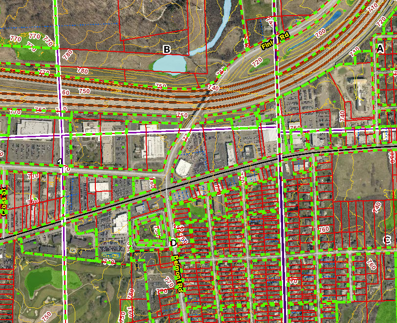
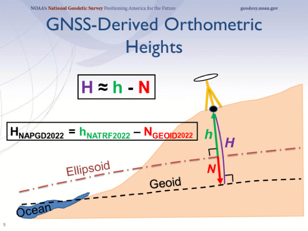
Our reliance on state plane coordinate systems (SPCS) is at an all-time high with the sharing of data by various parties being more seamless than ever. The notion that a permanent monument’s positional values will be constantly changing is a head-spinner to most.

    NGS has also stated that their new system and procedures will not maintain data values for SPCS (see NGS State Plane Flyer). There are currently 125 SPCS zones and 3235 county systems throughout the US and territories in place that rely on NGS data as the main framework, so having tools for reference and conversion in place will be crucial. Thus, it will be a herculean task to create a procedure/process to easily pass coordinate values between our many static systems worldwide and the new dynamic but very robust system underway from NGS.

    Based upon information currently available about the NAD2022 system, it would be more efficient for all those who use geolocation data to modify their thinking to adapt to a dynamic coordinate system. However, this is a similar situation to early scientists and geographers throwing out all references to flat-earth maps and atlases. For surveyors in the twilight of their careers, these are radical items to consider and a far cry from the standardized chain and theodolite. (Maybe there will be mass hysteria…)

    The good news is that we have very intelligent people in the surveying and geodetic community who are working on solutions for the masses. The beauty of newer technology is how quickly hardware and software can be adapted to fit these new data conditions. Getting the word out on these changes and educating our profession will be a key factor to its success.

    Further Refinement of Coordinate Systems

    While the use of GNSS has enabled the discovery of time as a significant variable in geolocation, it has also expanded out coverage area of coordinate systems to much larger areas. Distances that could not be computed prior to GNSS are now easily attained and large projects can be managed within a common coordinate system. County, regional and state agencies can now create large-scale GIS databases that utilize a single coordinate system as well.

    However, there are two differing tracks being formed with the continued development of the new datum by NGS. While the new datum will become more precise and predictable, there are movements in opposing camps to make changes in user coordinate in the furthest possible ways: statewide single zone system versus county/regional low distortion projection (LDP) systems. They both have their strengths and weaknesses, and will depend on the application of the user to choose the appropriate system.

    • Most states currently have two or more zones so there potential to combine all zones into one, but a major drawback will be the loss of accuracy away from the defining points. For GIS users, this accuracy will more than adequate and will allow the merging of data from across the state into one unified system.
    • Surveyors, however, are an interesting bunch in that they accept only the most accurate AND precise measurements. The growing use of LDP is rapidly changing the implementation and management of coordinate system in smaller areas such as counties and regional DOT districts.

    Burch0517007
    However, both systems have a place in our surveying and mapping world. NGS has stated that while they will help with transformation software and apps, it will leave the decision of legislative standards to each state. It will be paramount that each state study what makes the most sense for its users and pass the appropriate legislation.

    Burch0517009

    “The days are long but the years are short”

    As I look back and realize how much has changed with modern technology and overall knowledge of our profession, it is with much anticipation how much more will change with advancements we don’t even know about yet. The electronic distance meter (EDM) was revolutionary for many surveyors and I’ve waxed poetic about my feelings regarding RTK GNSS in past columns (GPS World May 2016). Once again, however, technology and information based upon its use has revolutionized our data system.

    As a profession, surveyors have embraced GNSS use and data collection from the early implementation of the system. And while the advances of UAV use, laser scanners and LiDAR along with software improvements have revolutionized data collection, these proposed coordinate improvements by NGS will bring more potential quality information into the surveyor’s hands.

    And while time is money as Mr. Franklin famously stated, 2022 is just around the corner. A good friend of mine is famous for saying: “Good coordination begins with good coordinates.” The work performed by NGS is helping us do just that. The entire surveying, mapping and geodetic community has lots to accomplish to be ready for the changes from NGS. Let’s get to work.