Smart GEO Expo 2021 takes place at the Coex Hall C3 and C4 in Seoul, South Korea, July 21-23. An online version will also be available.
The Smart GEO Expo aims to promote spatial information industry development and support overseas expansion of domestic companies.
The Smart GEO Expo has become an annual event since 2008, when separate events such as GIS Korea, Cadastral Innovation Expo and Measurement Day were integrated and expanded, owing to the reorganization of government departments related to spatial information.
The expo includes an exhibition where host, organizers and many other geospatial information-related companies and agencies provide showcases. The event also includes the International Meeting for the Advancement of the Geospatial Information Cooperation for expansion of exchange and information sharing with foreign guests.
While GPS will always be an integral and irreplaceable part of positioning, navigation and timing (PNT) technology, assured PNT must take a layered approach for true resiliency.
A GPS World webinar sponsored by Spirent Federal Systems will explore this topic. Registration is now open for the free webinar, which will be held June 24.
Join experts from Spirent and Northrop Grumman as they examine
the future of inertial navigation in assured PNT and GPS augmentation
EGI-Modernization
coherent GNSS and inertial sensor emulation
exploring and simulating emerging alternative space-based PNT RF signals.
Expert presentations will be followed by a question-and-answer session; questions will be accepted both before and during the webinar.
To register for the webinar, visit this link. Registration is free.
Date: Thursday, June 24, 2021 Time: 1 p.m. EDT / 10 a.m. PDT / 7 p.m. (1900h) Central European Time Duration: 60 minutes + extra time for Q&A Sponsored content by: Spirent Federal
Jennifer Smith joined Spirent Federal in 2004. Jen has responsibilities in business development as well as in general operations. She has experience in project management and contract negotiations.
Smith has a B.A. and a J.D. and is a member of the Utah Bar Association.
Naveen Joshi leads the Strategy and Business Development for Northrop Grumman’s Navigation and Integrated Cockpit business. He sets product strategy, shapes technology roadmaps, and advises Northrop Grumman leaders on the application of PNT technologies. His previous roles at Northrop include program director, program manager, engineering manager and various roles in engineering.
Outside of Northrop Grumman, Joshi held roles in management consulting and eCommerce, and ran an entrepreneurial venture.
Joshi earned a bachelor’s degree in computer science from Cornell University and an MBA from UCLA’s Anderson School of Management.
Mark Holbrow’s 30-year professional career has concentrated on the innovative design, development, and successful commercialization of electronic test equipment.
In his current role, he is responsible for the technical team management, new product design, and future direction of Spirent’s portfolio of world-leading positioning, navigation, and time (PNT) test solutions.
Holbrow has a passion for the sometimes overlooked discipline of “test methodology” and thoroughly enjoys the technical and business development demands required to identify, and innovatively solve, complex test challenges.
Roger Hart joined Spirent Federal in 2015. Roger has responsibilities in engineering development and support, sales and customer training. He has worked in development of spacecraft navigation systems, including GPS, for civil, NASA and defense applications since 1986.
Hart has a Bachelor of Arts in physics and Master of Science in mechanical engineering (space track) from Utah State University.
To register for the webinar, visit this link. Registration is free.
A link to the live event will be sent to you two hours before the event. Your personalized event URL will be automatically generated by the ON24 system. To ensure receipt of the email, please whitelist this email address by adding it to your contacts: [email protected].
This presentation will begin at 1 p.m. EDT / 10 a.m. PDT on Thursday, June 24th. A recording will also be sent to you the following day so you can watch it on-demand.
Audience members may arrive 15 minutes prior to live time. If you have any questions, please contact event producer Danielle Pesta at [email protected].
$50K prize purse for solutions to advance computer vision for time-sensitive mapping
The National Geospatial-Intelligence Agency (NGA), Johns Hopkins University Applied Physics Laboratory and NASA have launched a crowdsourcing competition, the “Overhead Geopose Challenge,” which is being implemented by DrivenData and HeroX.
The challenge seeks solutions that make overhead images more useful for time-sensitive applications like security and disaster response. Participants are competing for a prize purse of $50,000. To accept the challenge, visit this website.
The challenge seeks to build computer-vision algorithms that can effectively model the height and pose of ground objects for monocular satellite images taken from oblique angles.
Overhead satellite imagery provides critical time-sensitive information for disaster response, navigation, and security. Most current methods for using aerial images assume that the images are taken from directly overhead.
However, the first images available are often oblique. These camera orientations complicate useful tasks like image alignment and change detection that are needed to ensure that maps are accurate in dynamic environments.
Solvers will transform RGB images taken from a satellite to accurately determine each object’s real-world 3D structure or “geocentric pose.” Geocentric pose is an object’s height above the ground and its orientation with respect to gravity. Calculating geocentric pose helps with detecting and classifying objects and determining accurate object boundaries.
NGA is continuously seeking novel concepts for assured positioning, navigation, and timing, said NGA Research Chief Scientist John Main. “We think the broader innovation community can help us support disaster response operations more effectively by exploring novel ways to understand where things are happening — or even better where things will be happening — during an emergency event. This is NGA Research’s goal and the reason we tap scientific and technical talent and ideas from national labs, universities, and businesses.”
“This is a hard computer vision problem that will benefit from the diverse approaches that a machine learning challenge can bring to bear,” said Greg Lipstein, co-founder and principal of DrivenData. “This is a great opportunity to bring together a fascinating dataset with a passionate community of experts to generate innovative solutions for disaster response and other time-sensitive needs”
“Our global network of problem-solvers is perfectly suited to support the advancement of state-of-the-art methods for using and understanding satellite imagery,” said Christian Cotichini, CEO, HeroX. “Having great minds come together for an initiative like this will help us more quickly and more effectively support people in times of need.”
Eligibility to Compete and Win Prizes
The challenge is open to anyone aged 18 or older not affiliated with DrivenData or the challenge sponsor and permitted to compete under the laws of the U.S. and their local jurisdictions.
Finalists will be determined by performance on a private test set of historical measurements, and bonus prizes will also be awarded for qualifying scores that reflect innovative approaches. All prize-winning approaches will be shared under an open-source license for learning and use by the community.
Women make up more than half of NV5 Geospatial’s eGIS business unit, which collects and analyzes data to develop custom applications for government clients.
Women make up more than half of the company’s team. From left are Alexa Ramirez, Nicole Wigston, Danielle Comely and Cherie Jarvis. (Image: NV5 Geospatial)
Even though women make up nearly half of the workforce, they are still highly underrepresented in the science, technology, engineer and math (STEM) field. In fact, the U.S. Census Bureau reports that while women have made gains since the 1970s, they still only account for about 27% of STEM workers.
But one company bucking this trend is NV5 Geospatial, which was formed with the 2019 merger of global engineering firm, NV5 Global, and Quantum Spatial Inc., North America’s largest geospatial data firm. Quantum Spatial brought with it a long history of providing innovative remote sensing, acquisitions and analytics solutions that answer some of the toughest questions and deliver unique insights. It has become the go-to provider of geospatial services for a wide range of clients, including major government agencies, the military, utility companies, engineering and construction firms, and corporate organizations. These clients value the organization’s proprietary and ground-breaking approach of using geospatial information to plan, manage resources, mitigate risk and contribute to scientific understanding.
Women make up more than half of NV5 Geospatial’s enterprise GIS (eGIS) business unit, which is responsible for collecting and analyzing data to develop custom applications for key government clients.
In 2020, the company named Cherie Jarvis as director of the eGIS team, which has grown to include three female project managers and four analysts that bring diverse backgrounds – from marine biology and zoology to environmental science to geology – to their work.
“Seeing so many women in GIS is not unusual for me because I think strong women attract other strong women,” Jarvis said. “The women on our team are not only experts in their field, but they are very detail oriented and have the technical, organizational and people skills to adeptly handle all the variables that come with the complex eGIS projects we manage.”
Jarvis, a PMP, Scrum Master and Certified Scrum Product Owner, has led several award-winning projects, including a decision support tool to guide environmentally sound dredging of offshore sand shoals for the Bureau of Ocean Energy Management (BOEM) and the National Oceanic and Atmospheric Administration (NOAA), and a portal to access navigation-related data and tools for sediment and ecosystem management for the U.S. Army Corps of Engineers (USACE).
Others on the team include:
Alexa Ramirez, senior project manager, PMP, GISP is a 13-year veteran of NV5 and its predecessor companies, where she previously specialized in lidar processing. She transitioned to the GIS team to create the data model for the BOEM Marine Minerals Information System (MMIS).
Danielle Comely, senior project manager, PMP, CSPO is an environmental scientist who recently joined NV5 from NOAA to work on BOEM, USACE and Southwest Florida Water Management District (SWFWMD) projects.
Ashley Reade, GIS analyst and one of the newest in the eGIS group, moved from the NV5 acquisition team to help manage MMIS and leverage her marine biology background to help assess fish habitat during dredging as part of the USACE South Atlantic Regional Biological Opinion (SARBO).
Liz Rodgers, senior GIS analyst, leveraged her degree in zoology to help build an environmental sensitivity index tool for NOAA and has been supporting work on USACE SARBO.
Emily Sandrowicz, GIS analyst, joined to work on MMIS, but moved to the geoESPIS (Environmental Studies Program Information System) project. She’s now pursuing her Master’s degree in GIS.
Maggie Satterfield, senior GIS analyst, brings a background in forestry to her work on the Bureau of Land Management (BLM) National Cultural Resources Information Management System (NCRIMS).
Nicole Wigston, senior project manager, PMP, CSM, brings a strong geography and technology background having previously worked for ESRI. She manages national data standardization projects for BLM and on projects automating NV5G internal data pipelines.
The accelerator collaboration, the first of its kind sponsored by a U.S. intelligence agency, aims to engage the geospatial ecosystem in the greater St. Louis region and beyond to develop innovations in geospatial technology through collaboration and a transfer of technology and subject matter expertise.
The program is seeking novel geospatial based technology from early-stage companies that serve four core areas:
data management
advanced analytics and modeling
data integrity and security
artificial intelligence
The value proposition is two-fold, said Josh White, NGA futures consultant.
NGA has the opportunity to convey its needs directly to industry, which helps commercial vendors develop technology solutions tailored for the agency.
NGA galvanizes its workforce toward transparency, innovation and modernization.
Great innovation ecosystems are equipped to grow and attract talent, said Dedric Carter, Ph.D., chairman of Missouri Technology Corporation. “The collaboration is helping to fuel such an ecosystem by providing opportunities in the state for around eight promising early-stage geospatial sector companies from across the country,” he said. “Bringing the best potential from near and far is the attractive force that we need to super-charge innovation.”
Companies selected to participate in the program will have access to incentives including a $100,000 non-dilutive grant, mentoring and coaching from subject matter experts from the NGA and Capital Innovators, investor connections and access to the greater Capital Innovators network, participation in a demo day in St. Louis, and more.
“The NGA Accelerator powered by Capital Innovators has been an amazing experience!” said Tyler Carter, COO and founder of InfraLytiks. “We jumped right in to discussing problem/solution fits with NGA during the first week of the accelerator. We have also been working with the Capital Innovators team to improve and develop other areas in our business including our internal operations and sales and marketing.”
Early-stage geospatial technology companies from across the U.S. are invited to participate in the program. Applications will close June 23 at 11:59 p.m. CT.
A technician scans for UXO on steep terrain in a wooded GPS-denied area. (Photo: Kaarta)
Kaarta and Exploration Instruments have announced a collaboration and distribution agreement to address the needs of the unexploded ordnance (UXO) and geophysical industries.
Kaarta provides real-time mobile 3D reality capture, and Exploration Instruments LLC (EXI) has expertise in near-surface geophysical equipment and applications.
EXI now offers rental, sales, and training for Kaarta’s SLAM-based mobile mapping systems and the integration with geophysical equipment such as digital geophysical mapping (DGM) and advanced geophysical classification (AGC) sensors.
Contamination and munitions from former combat areas or military training grounds is a global hazard. In the U.S. alone, more than 5,400 sites covering millions of acres have been identified for investigation and environmental restoration according to the U.S. Army Corps of Engineers.
The general remediation approach pinpoints buried ordnance location using electromagnetic and magnetic detection systems with GNSS positioning technology. While these systems perform well in open areas, other common environments such as steep terrain and wooded areas under tree canopy are challenging to find and remediate UXO.
The most common method for achieving required positional accuracy for DGM or AGC in wooded terrain is the use of robotic total stations (RTS) to tie surveyed locations to detection systems. However, RTS line-of-sight requirements make mapping and classification difficult and time-consuming, resulting in slower production rates and increased effort as data-collection teams must revisit common data gaps in the RTS coverage to achieve 100% coverage of the mappable areas.
Kaarta’s simultaneous location and mapping (SLAM) solution provides accurate global positions within several centimeters in these demanding environments. Kaarta Stencil 2-16 mobile mapping system combines lidar, an inertial measurement unit (IMU) and visual odometry measurements to build a 3D map of the environment while updating global position data in real-time when moving through the map, without the need for external signals such as GNSS.
The U.S. Army Corps of Engineers tested Kaarta’s Stencil 2-16 to provide rapid positioning data in GNSS-denied areas and found it provides positional data with the required accuracy for DGM and AGC at military munitions response sites.
Kaarta systems are successfully integrated and used with a range of geophysical equipment including Geometrics MetalMapper 2×2, Geonics EM-61, and White River Technology’s APEX systems. EXI ties it together by providing geophysical expertise, training and access to the latest equipment through both rental and sales. Stencil 2-16 integration with other sensors is easy using customizable GNSS NMEA strings and supports a wide range of RS-232, USB and Ethernet interfaces.
“It’s exciting when a combination of technologies come together to address such a significant problem as locating UXO in the most challenging of environments,” said Dave Duggins, UXO applications specialist at Kaarta. “We’ve been out in the woods with customers and are thrilled with the results we’ve achieved which include increased production rates with fewer personnel. Partnering with EXI to bring this solution to market is a perfect match.”
“There are hundreds of thousands of wooded acres that still need to be remediated,” said Dennis Mills, EXI’s President, “Providing geophysicists with a proven integrated solution that significantly improves productivity over current methods is a win all around.”
Kaarta systems can also be integrated with other sensors that use GNSS for positioning – ground penetrating radar, magnetometers, terrain conductivity meters — for a wide range of applications where positioning is needed in GNSS-denied areas. Kaarta was recently issued a patent covering its novel approach to fuse data captured by SLAM systems with data from other sensors to measure and localize sensed data in the scanned environment.
EXI will be the primary provider of Stencil 2 rentals, sales, and training to the UXO and geophysical industry.
1Spatial, a company with location master data management (LMDM) software and solutions, has been granted a UK patent for modification and validation of spatial data.
The UK patent protects the use of 1Spatial’s rules engine technology, which is used in products such as 1Integrate and 1Data Gateway, further strengthening the group’s international patent coverage, which includes a U.S. patent for modification and validation of spatial data.
The 1Integrate rules engine solves the issue of managing the quality of data in one or more databases. Ensuring good-data quality, which is also referred to as master data management is an issue for most organizations, especially where databases are large, complex and interconnected with other systems.
Bad data quality reduces the operational efficiency of organizations and prevents effective decision making. The 1Integrate rules engine solves this issue using a rules-based validation process which checks and cleans the data in order to measure, improve and protect the quality of the data and hence improve the operations, decisions and software implementations that depend on it.
“As pioneers in the cleansing of location data, we are delighted to have been granted a UK patent for our rules engine technology, recognizing its power as a tool to ensure good quality data and facilitate trust when sharing data,” said Claire Milverton, CEO of 1Spatial. “Our understanding of the complexity of location data formats and sources, the rules that need to be applied and the issues that arise, has seen our technology be selected to power some of the world’s largest location data implementations.”
Skyward, a Verizon company, has announced its integration with Pix4D, a photogrammetry software suite for drone mapping. The partnership gives customers the ability to turn drone data into 2D maps and 3D models.
Enterprises and drone pilots can now plan flights, receive approval to fly in controlled airspace with LAANC, fly with Skyward’s InFlight ground control station, and process data using Pix4D — all from within the Skyward platform.
“Skyward has been bringing our customers tools to access airspace, plan and fly — now they can produce business-ready data deliverables without leaving Skyward,” said Mariah Scott, Skyward president. “Enterprises in construction, energy and utilities, and the public sector can get even more ROI out of their drone programs when combining Skyward’s drone management platform with Pix4D’s market-leading photogrammetry tools.”
Skyward Mapping & Modeling, powered by Pix4D, enables customers to create, view, measure, and export 2D orthomosaic maps and 3D photogrammetric models right from Skyward’s web app. With the processing power of Pix4D, Skyward customers can get business-ready data sets through a seamless plan, fly, process workflow.
“Enterprises are seeking to scale their drone operations and transform their businesses with better data and faster time to insight. Skyward’s platform, along with the power of Pix4D, delivers a powerful, comprehensive solution,” said Christopher Cressy, Pix4D managing director for North America.
To learn more about Skyward’s mapping and modeling features, join a webinar on June 8 at 2 p.m. ET. Enterprises and commercial operators can try Skyward Mapping & Modeling powered by Pix4D free for 30 days.
The Indian Institute of Technology (IIT) Roorkee is offering a free online course on GNSS and Applications on the NPTEL platform. The four-week course will provide a basic understanding about digital elevation models (DEMs) and their applications in civil engineering and Earth sciences.
During the course, various DEMs and their sources, generation techniques, derivatives, errors and limitations will be discussed extensively. Surface hydrologic modeling using DEMs, modeling derivatives and their applications will also be discussed.
Intended audience. Under- and post-graduate engineering and post-graduate science students and faculty.
Pre-requisites. Current students of engineering, post-graduate science students and Ph.D. students should have basic knowledge of geographic information systems (GIS) and remote sensing.
Industry support. Geoinformatics companies (such as NIIT, Esri India, Leica Geoinformatics, MapmyIndia, ISRO and more).
The course will be taught by Arun K. Saraf, professor in the Department of Earth Sciences at IIT Roorkee. He teaches courses on remote sensing, digital image processing, GIS, advanced GIS, geomorphology and related topics to undergraduate and postgraduate students of Geological Technology and Applied Geology. He has a Ph.D. in remote sensing from the University of Dundee, United Kingdom.
The course takes place July 26-August 20. Registration is open until August 2 and can be done through the SWAYAM platform.
By Col. Ryan Colburn Director, Spectrum Warfare Divisionand Portfolio Architect, Space and Missile Systems Center
The United States’ Global Positioning System is used now more than ever before. With an estimated four billion users worldwide, industries of all kinds continue to leverage the precise and consistent data streaming from the GPS satellites. The universal use of GPS signals permeates our lives and creates positive impacts around the globe.
We continue to deliver on our decades-long commitment to provide precise positioning and timing data to the civil, commercial and scientific communities. To support the evolving use of this global utility, the government and industry GPS Enterprise team has embarked on major investments to modernize GPS capabilities for our stakeholders. These efforts are occurring across all of our segments and combine to deliver incremental capabilities and improvements over time.
Colonel Ryan Colburn leads the team dedicated to modernizing the GPS constellation to meet tomorrow’s needs. (Photo: U.S. Space Force)
GPS ENTERPRISE ROADMAP
The GPS Enterprise Roadmap is an overview of the many programs we have in execution or planning stages. These efforts will enable us to deliver new and improved positioning, navigation and timing (PNT) capabilities across all segments. We are upgrading each of the three GPS segments (space, control, and user equipment) to deploy modernized capabilities while continually replenishing the GPS constellation; ensuring we have 24 or more operational satellites available at least 95% of the time.
Additionally, we are always working on what’s next. We are actively researching, prototyping and planning; looking at how we will continue to evolve this architecture into one that is more robust and resilient than it is today. Our team is working to define the next set of capabilities for not only the GPS, as the backbone of our architecture, but also for ways to build off of this system and expand our ability to deliver PNT capabilities in new and useful ways.
“We continue to deliver on our decades-long commitment to provide precise positioning and timing data to the civil, commercial and scientific communities.”
2021 UPCOMING MILESTONES
Space Segment
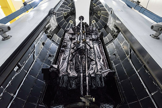
The GPS III program is off to a great start, further enhancing military readiness and bolstering the activities and assurance of all GPS users. The program continues to push space acquisition boundaries with the first reuse of a Falcon 9 rocket for a National Security Space mission.
Slated for launch in June, SV05 will launch on a flight-proven Falcon 9 booster that was recovered after successfully launching SV04 into orbit.
SV05 will continue the GPS constellation modernization effort and will deliver users a bump in performance and accuracy. The satellite features the interoperable L1C signal, the newest civilian L5 signal and anti-jamming improvements. For the military user, SV05 will become the 24th military-code (M-code) satellite, bringing M-code utility to its Initial Operating Capability.
The GPS III SV03 satellite is encapsulated in its protective launch fairings. (Photo: U.S. Space Force)
Ground Segment
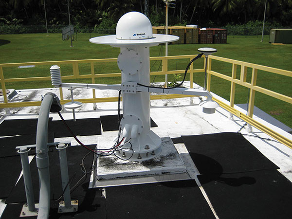
2021 will be a big year for the Next Generation Operational Control System (OCX). OCX will soon complete the installation of an entirely modernized network of 17 global monitoring stations. These stations allow OCX to monitor the full suite of legacy as well as modernized military and civil navigation signals, including L2C and L5.
In the factory, OCX will continue to use a newly accredited GPS System Simulator (GSYS) in support of mission software testing. In parallel, OCX will continue to replace mission equipment with Hewlett-Packard Enterprise hardware prior to its deployment to operational sites. Once deployed, connections to the GPS command and control antennas will begin, and interconnections to other mission systems will be established.
This includes the GPS Global Information Grid Automated Information System (GGA) subsystem, which will ensure timely dissemination of important navigation data to the public. OCX’s Launch and Checkout System (LCS) will be used to launch and initialize GPS III SV05.
OCX 3F is a modification of the OCX baseline to support GPS IIIF-specific mission requirements. OCX 3F will maintain backward compatibility with the existing systems to support the legacy GPS constellation and will integrate future GPS IIIF capabilities. For example, it will implement command and control of the Regional Military Protection (RMP) and Rapid Warfighter Effects requirements. We are on track for an OCX 3F contract award later this year.
A GPS Antenna is installed at the Diego Garcia Tracking Station, part of the Satellite Control Network operated by the Space Force. (Photo: U.S. Space Force)
User Equipment Segment
In 2021, Military GPS User Equipment (MGUE) Increment 1 will culminate its ground user form factor efforts by completing a Field User Evaluation (FUE) of M-Code GPS technology in two service-nominated lead platforms. The Army FUE will be conducted with multiple variants of Stryker vehicles.
Meanwhile, the U.S. Marine Corps will use the Joint Light Tactical Vehicle (JLTV) for their FUE. Both events will assess the performance of the enhanced GPS receivers in operationally relevant environments. Toward the end of 2021, MGUE Increment 1 will deliver the aviation/maritime form factor, which will enable Navy Guided Missile Destroyer (DDG) and USAF B-2 bomber lead platform integration in 2022.
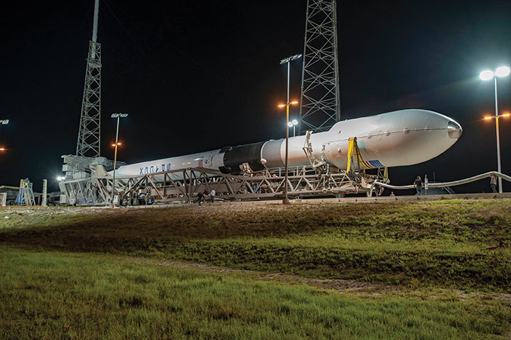
GPS III SV03 is rolled out to the launchpad before its daytime launch on June 30, 2020.
Enterprise Integration
None of these systems are delivered in a vacuum, and we work hard to integrate them all. It is the only way we can continue to deliver on our promises outlined in our published standards. From test campaigns and requirements management, to model-based systems engineering and roadmaps; it takes a united team of government and industry partners to deliver truly integrated capabilities.
We have many exciting milestones this year and we have a world-class government and industry team working tirelessly to ensure continued delivery, maintenance, and operations of GPS Enterprise capabilities. Our motivation is simple — continuing to deliver and evolve the gold standard PNT capabilities we all rely on day in and day out.
The U.S. Space Force’s Space and Missile Systems Center (SMC), located at the Los Angeles Air Force Base in El Segundo, California, is the center of excellence for acquiring and developing military space systems. The SMC’s portfolio includes space launch, global navigation satellite systems, military satellite communications, a meteorological satellite control network, range systems, space-based infrared systems, and space situational awareness capabilities.
The M-code-enabled SV03, shown launching in June 2020, was joined by SV04 in December. SV05, the 24th M-code-enabled satellite, is expected to launch by July 2021, completing the Initial Operating Capability of M-code. (Photo: U.S. Space Force)
Drone company Parrot is partnering with Rapid Imaging, a technology provider delivering geospatial augmented reality (AR) and situational awareness solutions to government and enterprise users.
The partnership pairs Parrot ANAFI USA platform drones and the FreeFly SDK with Rapid Imaging’s SmartCam3D SDK, a geospatial augmented reality and situational awareness platform for unmanned aircraft systems.
SmartCam3D overlays geospatial data such as street vectors, road names, points of interest, polygons and other pertinent map entities onto real-time, full-motion video (FMV) provided by ANAFI USA’s 4K HDR video, 32x zoom and live video streaming capabilities. This provides mission personnel with advanced situational awareness as they perform critical drone operations.
SmartCam3D also allows end-users to interact with live drone video in the same ways they would a map display, such as dropping a pin to mark a location or geocoding a selection from the real-time video stream.
These situational awareness capabilities provide opportunities across a variety of mission sets: airborne law enforcement, insurance, industrial inspections, natural disaster response, real estate and search-and-rescue operations.
The SmartCam3D SDK is a turn-key solution for UAS platform providers seeking to enrich their offerings with geospatial augmented reality and situational awareness tools. Features include geospatial AR, allowing users to enjoy a “Google Maps” type experience but with live drone video as the background layer rather than a satellite image. Granular declutter options allow users to select the types of map entities displayed on their live video feed.
Custom GIS data integration allows users to import their own geospatial data to display. Pin-dropping allows users to mark locations within the live video with AR annotations and communicate those locations to a map display.
Also, forward- and reverse-geocoding allow professional drone pilots to designate a point in the video and immediately receive the geospatial data associated with that point (lat/long or address) or designate a location and mark the location with an AR annotation within the video display.
Finally, cross-Cuing allowing end-users to simultaneously navigate a full-motion-video display and map display.
“Leveraging Parrot ANAFI USA’s precise GPS coordinates and advanced flight features, SmartCam3D® provides first responders and military personnel with up-to-date geospatial AR overlays on live video, combining the benefits of both a 2D map display and a Full-Motion-Video display into a single operating picture.” said Jerome Bouvard, director of Strategic Partnerships, Parrot. “This new partnership will provide easy-to-comprehend data to better assist first responders into making quick and accurate decisions during high-stress missions.”
All data captured through SmartCam3D during sensitive missions is secure, as Parrot drone users must opt-in to share flight data with Parrot’s secure to store footage. Parrot ANAFI USA also features secure digital (SD) card encryption, which ensures complete protection of photos and videos if the drone or the SD card is lost.
The SmartCam3D SDK is available for Android, iOS, Linux, and Windows systems for use with ANAFI and ANAFI USA platform drones.
 Smart GEO Expo 2021 takes place at the Coex Hall C3 and C4 in Seoul, South Korea, July 21-23. An online version will also be available.