The Russian Defense Ministry successfully launched GLONASS-M 51 (known as 751 in orbit) aboard a Soyuz-2.1b rocket with a Fregat upper stage on Feb. 7, 2016.
Russia’s Roscosmos space agency could launch up to four GLONASS navigation satellites in 2017, reports sputniknews.com. The satellites will be launched only to replace malfunctioning satellites if necessary, according to Deputy Director General for Automatic Space Complexes Mikhail Khailov.
“It is planned to carry out up to four launches [of GLONASS satellites] in 2017 … We will carry them out only when necessary, including the use of the Proton rocket,” Khailov said at the meeting of the International Committee on Global Navigation Satellite Systems (ICG). The ICG meeting, organized by Roscosmos, took place on Nov. 6-11 in Russia’s southern city of Sochi.
China has successfully launched a navigation satellite that will conduct in-orbit experiments using pulsar detectors to demonstrate new technologies, reports The Indian Express.
The X-ray pulsar navigation satellite XPNAV-1 was launched Nov. 10 atop a Long March 11 solid-fueled rocket from the Jiuquan Satellite Launch Center in China’s northwest.
The experimental pulsar navigation mission carries two sensors to pick up incoming X-rays from objects scattered across the galaxy, and use the detections to plot the craft’s position without relying on GPS satellites or pre-loaded navigation fixes.
Physics Worldpublished an article that describes pulsar navigation in June 2013.
Chinese officials said the XPNAV-1 satellite weighed more than 440 pounds (200 kilograms) at launch, and was developed by the China Aerospace Science and Technology Corp., a contractor in the country’s state-run space industry.
DJI has updated the capabilities of its largest drone series by introducing the Matrice 600 Pro, which offers improved flight performance, a more powerful battery charging system and better loading capacity for industrial equipment, cinema cameras and other professional aerial applications.
The M600 Pro’s A3 Pro flight controller comes with triple modular redundancy and diagnostic algorithms that compare sensor data from three sets of GNSS units, which enhances precision control while improving overall safety. Vibration damping balls have been added to the flight controller’s redundant IMU module and main controller, absorbing more shake and reducing more noise.
The compatibility with D-RTK GNSS makes the A3 Pro withstand magnetic interference and provides centimeter-level accuracy, which makes it suitable for industrial applications.
“The M600 Pro is DJI’s most advanced platform for aerial cinematographers and commercial users. With its simple and easy setup system, triple redundancy and improved stability, the platform offers an unparalleled experience for professional users,” said Aaron Zhao, Senior Product Manager at DJI.
DJI’s E2000 Pro dust-proof propulsion system simplifies maintenance and its active cooling motors ensure that operation is reliable for extended periods of time.
The M600 Pro is compatible with DJI’s Zenmuse camera series, the Ronin-MX gimbal and DJI Focus. It supports a payload of 6 kilograms, meaning it can carry a range of cameras from Micro Four Thirds systems to the RED EPIC.
The M600 Pro has been optimized for transportation and comes with pre-installed arms and antennas. When folded, the platform is smaller than the standard M600. The M600 Pro comes with an updated battery charging hub, enabling users to charge the six intelligent batteries at the same time and thereby reducing overall charging time.
Trimble is offering office software, site positioning and machine control solutions designed for site and utility contractors and owner/operators. These solutions offer small to mid-sized contractors a reliable, flexible and affordable option to leverage construction technology.
Many contractors already use SketchUp Pro for layout and visualization. SketchUp’s affordable price point and ease of use make it an ideal solution for small site and utility contractors who do not have a software specialist on staff.
Now, SketchUp files can be exported to Trimble SCS900 Site Controller Software using the new Trimble Site Contractor extension for use in site positioning applications.
Site Positioning
Trimble Site Positioning Systems have also made significant improvements for smaller contractors. Trimble SCS900 Site Controller Software has introduced two new capabilities, EZ Level and BaseAnywhere.
EZ Level replaces traditional laser transmitters with GNSS or total stations for easy elevation checking when no design is available. BaseAnywhere allows contractors to quickly set up their Trimble SPS585 GNSS Smart Antenna as a base station anywhere on the site, with no survey control necessary, making it much simpler and faster for a non-surveyor to use GNSS.
In addition, corrections can now be streamed to the SPS585 using BaseAnywhere and Wi-Fi. No radio is needed, so smaller contractors have a very affordable way to receive GNSS corrections on site.
Machine Control
The Trimble GCS900 Grade Control System can now be installed on many skid steer loader grading attachments from a variety of manufacturers. The installation includes integration to the machine’s joystick controls, so contractors can take full advantage of the technology on their machine to increase productivity and accuracy.
“Trimble has made it easier than ever for smaller contractors to take advantage of construction technology,” said Scott Crozier, director of marketing for Trimble’s Civil Engineering and Construction Division. “With office software, site positioning and machine control solutions designed to make the technology easier to use and more affordable, site and utility contractors are able to enjoy increased productivity gains and efficiency that larger companies benefit from today.”
Harxon has released its next-generation triple-frequency Helix Antenna HX-CH7603A, which has excellent performance and high efficiency in a compact form factor, the company said.
Harxon’s new-design helical antenna HX-CH7603A is capable of GPS L1/L2, GLONASS L1/L2 and BDS B1/B2/B3. Though compact, it provides high peak gain (more than 3.5 dBi) and wide beam width to ensure the signal receiving performance of satellite at low elevation angles.
HX-CH7603A is equipped with an O-ring and gold-plated SMA (sub-miniature version A) connector that makes the antenna waterproof-grade, reaching IP67 once installed on a mating surface. The antenna is designed for applications requiring minimal integration effort or for retrofitting existing products.
Features
High gain (3.5dBi) with superior tracking performance
Very low noise figure
High stability and high repeatability at phase center
The protective fairing is lowered onto the four Galileo satellites and their dispenser resting atop an Ariane 5 launcher. The fairing was placed on Nov. 3. (Photo: ESA)
Europe’s next four Galileo navigation satellites are together on their dispenser atop the Ariane 5 launcher due to launch them next Thursday from Europe’s Spaceport in French Guiana.
Having been attached to their dispenser as a combined upper composite, the four 715-kg satellites were transported to the final assembly building on Oct. 31.
The next step saw them put on top of the upper stage of their customized launcher. Finally, on 3 November, the quartet was enclosed within a protective fairing — the last time they were seen by human eyes — to protect them from the onrushing atmosphere during ascent.
In the following week, the rocket was prepared for takeoff, including filling its cryogenic upper stage, in preparation for the move to the launch pad on Tuesday, Nov. 15.
In development since 2012, this new Ariane variant has evolved from the version used to place ESA’s 20 t Automated Transfer Vehicle vehicle into low orbit. The new launcher has to carry a lighter payload but needs to take it up to the much higher altitude of 22 900 km.
Cutaway view shows the four Galileo satellites mounted on top of a specially adapted Ariane 5 rocket underneath the aerodynamic fairing. (Image: ESA)
The target orbit is actually 300 km under the Galileo constellation’s final working altitude. This leaves Ariane’s upper stage in a stable ‘graveyard orbit’, while the four Galileos manoeuvre themselves up to their final set height.
The decision to proceed with this launch was taken after in-depth analysis of two recent anomalies occurring in rubidium atomic clocks aboard Galileo satellites in orbit.
Galileo satellites 15–18, attached to their dispenser, are placed onto their Ariane 5 launcher. (Photo: ESA)
Highly accurate timing is core to satellite navigation. Each Galileo carries four atomic clocks to ensure quadruple redundancy of the timing subsystem: two Passive Hydrogen Maser clocks plus two Rubidium Atomic Frequency Standard (RAFS) clock.
Investigations jointly conducted by ESA and industry point to a short circuit in these two RAFS unit. The ultimate objective of the fourfold redundancy on each satellite is to ensure operations over their planned lifetime.
Taking into account the redundancy and considering that the upcoming launch will increase the constellation’s overall robustness,it has been decided to maintain the mid-November launch date. Once this latest flight is complete, there will be 18 Galileo satellites in orbit — the single largest increase of any navigation satellite constellation from a single launch.
This will mark the first time that ESA deploys four satellites simultaneously. Usually, simply shepherding a spacecraft through the first critical days in orbit is a demanding enough task. A combined team from ESA and France’s CNES space agency based in Toulouse, France, will make contact, establish control and then see the quartet through its initial, critical, activities.
Two further Ariane 5 flights are planned for Galileo during the next two years, one each for the constellation’s remaining orbital planes.
Already above Earth’s atmosphere, Ariane’s aerodynamic fairing is jettisoned and the four Galileo satellites enter space for the first time. (Image: ESA)
AT&T and the National Aeronautics and Space Administration (NASA) are researching traffic management solutions for unmanned aircraft systems (UAS).
The goal is an Unmanned Aircraft System Traffic Management (UTM) solution that supports safe and highly secure operation of drones in the national airspace.
AT&T has been working with NASA and other companies to make UAS flight-path monitoring, flight planning, navigation, surveillance and tracking safer in the areas of wireless networking and advanced technologies.
AT&T brings expertise in networking, Internet of Things (IoT), cloud, identity management and cybersecurity to the effort.
“Working with NASA and others, we are designing the management system for a new frontier in aviation,” said Mike Leff, vice president, Civilian, AT&T Global Public Sector Solutions. “Drones are already used in agriculture, public safety, construction, utilities, real estate and television. This research can help support the commercial and private use of drones nationwide.”
A key element AT&T and NASA are researching is the potential impact of cybersecurity threats. The vast availability of drones — and their many current and potential uses — could increase their risk of cyberattacks. AT&T advocates cybersecurity protections designed into the system from the outset.
AT&T will continue to participate in NASA demonstrations, workshops and studies related to airspace operations concepts and technologies.
AT&T moderated an expert panel discussion about the role of cybersecurity in UTM Nov. 10 at the Oncenter in Syracuse, New York. The panel took place as part of UTM Convention 2016.
AT&T has also implemented a national drone program. The company uses drones to inspect cell towers and measure network performance at venues and locations across the country.
Additionally, Chris Penrose, President of AT&T’s Internet of Things Solutions, was selected as a member of the FAA’s Drone Advisory Committee earlier this year. The group identifies and advises actions to support the safe introduction of UAS into our national airspace.
Asteri Navigation will introduce a new line of rugged, compact and fully integrated GNSS receivers on Nov. 15 at the 2016 Autodesk University in Las Vegas, Nevada.
Suitable for geospatial field data collection and inspection applications that require high accuracy positioning, the Asteri X-Series receivers are light enough to be mounted to external sensors or worn on the body or arm.
Asteri Navigation will debut the affordable X-1 and X-2 receivers in booth No. 1783 at Autodesk University, which runs from Nov. 15-17 at The Venetian in Las Vegas. The X-3 is scheduled for release in December.
The compact Asteri receivers were designed with safety and ease of use in mind. Each device weighs just 11.3 ounces with the 12-hour lithium battery. Their 2.8-inch by 5.4-inch size allows them to fit safely in shoulder or arm pouches.
The internal single-frequency antenna enables users to capture accuracies of well under 10 centimeters with RTK/VRS corrections. This integrated design allows users to work in difficult terrain without worrying about equipment and antennas getting snagged or broken.
Engineered to provide centimeter-level accuracy with Real-Time Kinematic (RTK) or Virtual Reference Station (CRS) correction when connected to an external antenna, the Asteri GNSS receivers support a generic NMEA 0183 GNSS data protocol. This makes them compatible with data collection and field mapping applications supporting the same protocol and ideal for users who want to develop their own software applications for inspection and GIS data capture activities.
The new receivers can communicate via Bluetooth or cable with most popular devices used for field data collection, including utility line locators, ground penetrating radar, data loggers, laser rangefinders, smartphones, and tablets.
Asteri expects the X-Series will be used extensively in mapping and survey applications related to asset management, pipeline operation, utility construction, forestry, electric staking, and underground utility location.
For users needing higher accuracy, an external multi-frequency antenna can be added to the provided port on the receiver. In addition, the Asteri X-3 will be compatible with Atlas GNSS satellite-based real-time correction services worldwide.
The three products in the X-Series provide varying levels of accuracy:
X-1 provides sub-meter accuracy out of the box.
X-2 offers accuracy of 1 meter down to 1 centimeter with RTK/VRS.
X-3 will achieve 1 centimeter with RTK/VRS, 30 centimeters with Atlas H30, 4-10 centimeters with Atlas H10.
The document was issued by the China Satellite Navigation Office. It defines the specification related to open service signals B1I and B2I between the space segment and the user segment of the BeiDou Navigation Satellite System. B2I will be gradually replaced by a better signal with the construction of global system.
Near Earth Autonomy, a specialist in autonomy solutions for unmanned aircraft, will support NASA’s mission to introduce unmanned aircraft systems (UAS) into the National Airspace (NAS). The contract was awarded through the NASA Small Business Innovation Research (SBIR) program.
Under this award, Near Earth will develop and demonstrate technologies that enable safe unmanned aircraft operation in the case of unexpected contingency situations. The SBIR award is in partnership with NASA Langley Research Center.
A Near Earth test UAV. (Photo: Near Earth)
UAS have the potential to impact modern society by providing efficient solutions for tasks such as surveying crop fields, inspecting large structures, and delivering packages and cargo; as well as taking on dangerous tasks such as fire-fighting and search and rescue.
Under the NASA award, Near Earth is developing an autonomous contingency system that will provide the UAV the ability to deal with wind disturbances, loss of power, and engine and sensor failures. The ACS will be a fully autonomous system that can discover and adapt to changes in unpredictable environments, while accomplishing the mission goals, with minimal or no human involvement.
“As unmanned aircraft are taking on these complex and hazardous conditions in low altitudes, it is essential to have the technology onboard that will identify the contingency, adapt to the situation, and make the necessary modifications for a safe and successful mission,” says Sanjiv Singh, CEO of Near Earth Autonomy.
The SBIR will build on Near Earth’s prior NASA-supported research centered on the perception and planning for small UAS, including Safe50, which enables safe and robust flight, particularly during the first and last 50 feet of the take-off and landing phases.
Near Earth Autonomy will exhibit its developments at the UTM Convention 2016 at Booth 119.
The GSC2000 now works with Engon tiltrotator excavator attachments.
Trimble and Engcon announced at Trimble Dimensions that the Trimble GCS900 Grade Control System can now be used with Engcon tiltrotator excavator attachments. Trimble machine control gives excavator operators using an Engcon tiltrotator precision guidance, which can result in time and fuel savings for contractors.
“Working closely with Trimble, we have made high-precision guidance available for Engcon tiltrotator attachments,” said Fredrik Jonsson, development manager at Engcon. “Major gains in productivity and precision can be realized by customers when the Engcon tiltrotator is used with the Trimble GCS900 Grade Control System.”
“We are excited about linking Trimble machine control to Engcon’s tiltrotator system,” said Scott Crozier, marketing director for Trimble’s Civil Engineering and Construction Division. “When operators receive accurate guidance in the cab about the tilt and rotation position of the bucket, excavations to designs can be performed faster and more productively.”
When Engcon tiltrotators are used with the Trimble GCS900 Grade Control System the bucket position and orientation are always visible regardless of bucket rotation. The operator can see the height and the rotation, so the attachment can be more efficient when used for mass excavation, fine grading and working in confined areas.
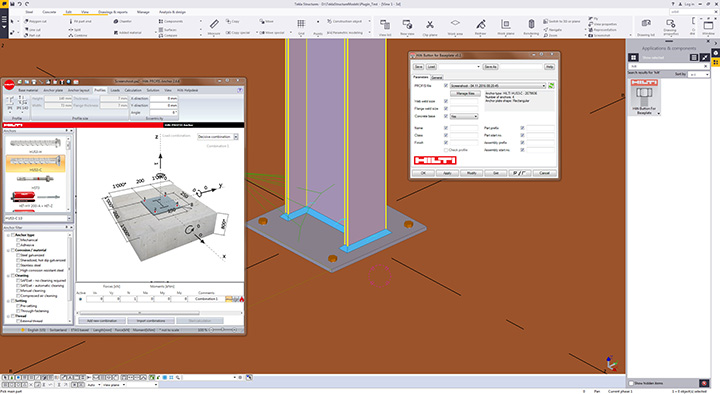
Trimble and the Hilti Group announced today that they are collaborating to deliver new software integration and data exchange solutions. These new integrated solutions provide a connected and improved digital experience for building construction professionals.
The Hilti PROFIS Plugin for Trimbe’s Tekla Structures.
New software and data exchange solutions include:
Sharing design information between software applications — Hilti PROFIS Plugin for Tekla Structures allows engineers and detailers to apply PROFIS design information directly in a Tekla Structures model through the Trimble Connect collaboration platform.
Easy access to data in the cloud — Hilti’s total stations POS 150/180 and PROFIS Layout Office solutions, and PROFIS detection solutions are now integrated with the Trimble Connect collaboration platform, enabling data to be easily exchanged and shared with others.
More design content, specification information and pricing at a user’s fingertips — Hilti has significantly increased its design content in the Tekla Warehouse to include anchors and cast-in solutions as well as providing more than 7,000 items through Trimble’s TRA-SER and LuckinsLive pricing services.
Since 2010, Trimble and Hilti’s relationship has been built upon shared values that focus on a deep understanding of customer needs and harnessing innovation to develop value-added solutions that increase customer productivity.
Hilti Corporation supplies the worldwide construction industry with technological products, systems, software and services.