A networked radio from Thales is designed to meet soldiers’ need for assured positioning, navigation and timing (PNT) while on foot.
The MBITR2 is part of a broader defense effort to provide PNT solutions in case of GPS jamming or interference. The MBITR2 is one of a number of devices and technologies, many still in development, to address this need.
For instance, under a Small Business Innovation Research (SBIR) contract with the Air Force Research Laboratory, Navsys Corporation is testing a network-assisted PNT acquisition algorithm to run on tactical radios such as the MBITR2. The algorithm is designed to provide improved acquisition performance in a GPS jammed environment by leveraging an innovative assisted GPS (A-GPS) architecture where navigation and timing data are shared across the tactical radio network.
The AN/PRC-148B MBITR2 ground tactical handheld radio is small, light and power-efficient. It builds on the legacies of both the earlier narrowband AN/PRC-148 MBITR tactical handheld radio and the wideband AN/PRC-154 tactical handheld radio. It covers the 30–512 MHz frequency range.
When equipped with the MBITR2, dismounted warfighters can connect with the wideband tactical Internet protocol and the voice network via the Soldier Radio Waveform wideband channel, while maintaining contact via the legacy narrowband channel.
The MBITR2 is interoperable with MBITR radios already deployed. More than 200,000 are now in the field, and Thales said the earlier generation radios can be upgraded with a low-risk and cost-effective approach.
Further, the MBITR2 retains compatibility with the existing installed base of ancillaries.
MBITR2 features
Two radios in one
Simultaneous two-channel (narrowband and wideband) operations
Adds a second wideband channel to the AN/PRC-148 to provide networking, data, and video capability
Retains the existing AN/PRC-148 JEM Type-1 capabilities and waveforms
Navsys Corporation received the 2016 James S. Cogswell Outstanding Industrial Security Achievement Award, the highest honor the Defense Security Service (DSS) presents to cleared industry partners, for its facility in Colorado Springs, Colorado.
Founded in 1986 by Alison Brown, NAVSYS has assisted other small businesses, including partner GPS Source, in establishing security programs for GPS products.
The company conducts research and development on global navigation technologies and specializes in GPS hardware design, systems engineering, systems analysis and software design for government and commercial customers.
Esri has made available the Trimble R2 GNSS receiver for collecting professional-grade GPS data with Collector for ArcGIS.
The GNSS receiver is rugged certified MIL-STD-810G, IP65 rated and compact, Esri says in a news release. The receiver is capable of delivering submeter and centimeter positioning accuracy in real-time to Android or iOS mobile devices via a wireless Bluetooth connection, or USB cable, to support geographic information system (GIS) or survey-grade workflows.
“Today’s geospatial professionals require flexible solutions which allow for configuration to meet their specific job requirements,” says Ron Bisio, vice president of Trimble’s surveying and geospatial Division. “By offering a complete, integrated solution, Esri and Trimble enable our joint customers to build a better and more reliable asset inventory using the mobile device, workflow and accuracy they choose.”
With the upcoming high-accuracy improvements to the Collector for ArcGIS App, Esri says the Trimble R2 GNSS receiver provides total flexibility to choose a solution based on the accuracy and GNSS performance level that suits the application. Now the locational precision of mobile devices can be enhanced via the Trimble R2 GNSS receiver. It is capable of supporting multiple global satellite constellation systems, including GPS, GLONASS, Galileo and BeiDou, and delivers GNSS positions in real time without the need for post-processing.
“Collector for ArcGIS is used by organizations to collect and update GIS data in the field,” says Dean Garner, Esri hardware solutions manager. “Many of our customers like the ease of use of Collector for ArcGIS on consumer handheld devices. Paired with the Trimble R2 GNSS receiver and the upcoming high-accuracy enhancements of Collector for ArcGIS 10.4, users can capture GIS data on their smartphones and tablets that meets the more stringent accuracy requirements of their organization.”
Designed for GIS professionals in a variety of organizations, the stand-alone Bluetooth or USB connected Trimble R2 GNSS receiver enables users to collect high-accuracy location data with Collector for ArcGIS on existing technology — whether it’s a modern smart device, such as a mobile phone or tablet, or a traditional integrated data collection handheld or tablet. The receiver can be pole mounted or carried in a backpack.
Spirent Communications plc is releasing a new series of multi-frequency, multi-GNSS RF constellation simulators. The GSS7000 series provides an entry to multi-frequency testing, with a modular approach to enable this new precision GNSS simulation system to expand with users’ needs.
The GSS7000 system will suit receiver, system and application developers who want to take advantage of new satellite navigation systems and the better accuracy offered by civilian, multi-frequency GNSS.
“Testing across multiple GNSS systems requires more channels and more frequencies with accurate modeling across multiple constellations,” said Stuart Smith, lead product manager for Spirent’s Positioning business unit. “The GSS7000 is a new type of simulator in terms of capability and flexibility. We have gone above and beyond traditional thinking to create a new system for a new era of GNSS test.”
Spirent Communications’ GSS7000 series of multi-frequency GNSS simulators provides a modular approach to testing.
The GSS7000 series offers faithful emulation of all civil GNSS systems and regional augmentation systems, and allows devices to be tested under a multitude of operating environments and error conditions, the company said. The GSS7000 has the flexibility to reconfigure satellite constellations, channels and frequencies between test runs or test cases. Four software control variants are offered.
For existing Spirent customers, the GSS7000 has been designed to be backward compatible, enabling the re-use of existing test cases. It allows full in-field upgradeability to add constellations, channels, and other options such as interference generation and sensor simulation.
Insurance company Munich Re uses spatial data-processing capabilities in SAP HANA with predictive analytics to assess risk and identify natural hazard profiles for millions of locations around the globe, so that it can efficiently coordinate loss adjustors after a major catastrophe or calculate hospitals, schools and roads impacted by an impending hurricane or flood. (Image: SAP)
SAP SE unveiled its SAP Geographical Enablement Framework, powered by SAP HANA, at the 2016 Esri User Conference, held June 27 to July 1 in San Diego, California.
SAP Geographical Enablement Framework helps organizations enrich business applications with geographic data from geographic information systems (GIS), such as Esri ArcGIS.
“In many asset-intensive industries such as energy, transportation and public sector, the ability to visualize business objects on maps is critical to improving efficiency and decision making,” says Irfan Khan, GM and global head, database and data management, SAP. “SAP Geographical Enablement Framework, powered by SAP HANA, can help organizations streamline the processing of both enterprise and spatial data for greater location awareness across business processes.”
To develop spatially enabled business applications, organizations can use the framework to:
Enable smooth integration and bidirectional navigation between SAP applications and Esri ArcGIS. Developers can use application programming interfaces published by GIS to fetch geospatial data. Also, business data augmented with geometric attributes can be published as a service, so that GIS users can access SAP business data from within their GIS tools.
Embed a responsive map user interface in a business application to display both business and spatial data simultaneously to provide greater insight.
Store the geometry of any SAP business object in the SAP HANA platform and accelerate spatial data processing in memory to deliver real-time insights, enriched with spatial context, to improve decision making.
Visualize, filter and search for business objects — such as functional location, equipment, linear assets, notifications or work orders — on a map from within a spatially enabled application. From a desktop or a tablet, users can also drill down through multiple map layers to gain better insight.
With continued collaboration between SAP and Esri, organizations can gain contextual insight from business and spatial data, enabling business and GIS users to work within the same multiuser access and editing environment, the company says.
“At EDF Renewable Energy, we have built a truly innovative enterprise business intelligence and data warehouse platform that combines Esri geospatial data along with asset sensor data and ERP transactional data in SAP HANA,” says Devang Shah, manager of database and business intelligence, EDF Renewable Energy. “This provides us with near real-time insights to help us operate more efficiently.”
As an open platform, SAP HANA is certified with the Open Geospatial Consortium, enabling organizations to easily consume spatial data from third-party spatial solutions that also adhere to the standard. SAP HANA also supports synchronous and asynchronous imports of data from any spatial reference system or coordinate reference system to ease access to local, regional or global geographic entities.
Native geocoding delivered by SAP HANA smart data quality helps rapidly convert addresses to latitude and longitude within SAP HANA, the company says.
“Munich Re is one of the leading reinsurance companies in the world,” says Andreas Siebert, head of geospatial solutions at Munich Re. “We use spatial data processing capabilities in SAP HANA, in conjunction with predictive analytics, to assess risk — such as to identify natural hazard profiles for millions of locations around the globe, to efficiently coordinate loss adjustors after a major catastrophe or to calculate how many hospitals, schools and roads may be impacted by an impending hurricane or flood.”
Drone-maker 3DR is teaming up with Esri to integrate 3DR’s Site Scan software with Esri Drone2Map.
3DR made the announcement at the Esri User Conference, held last week in San Diego.
Designed for the field professional, Site Scan is an intuitive, powerful and open aerial data capture and analytics platform that delivers an end-to-end solution ready-made for existing mapping and survey workflows, 3DR said in a news release. With Site Scan and Drone2Map, Esri customers can safely, quickly and easily conduct surveys with the Solo smart drone and effortlessly deliver that data to ArcGIS and ArcGIS Online.
“Aerial data capture technology is bringing about a revolution in surveying and mapping,” said Lawrie Jordan, Director of Imaging and Remote Sensing at Esri. “We are thrilled to partner with 3DR to streamline the creation of professional imagery products with Site Scan and Drone2Map for ArcGIS. Together we will accelerate the development and use of remote sensing across all industries.”
Site Scan automatically calculates a flight plan and Solo autonomously executes both flight and image capture. Images are processed and integrated with Esri Drone2Map to create high-resolution georeferenced maps and digital elevation models to share as tile or feature services in ArcGIS and ArcGIS Online.
“Capturing site data today is costly, time consuming and often dangerous. Drones can easily go where it’s inefficient or unsafe for field personnel, making it easier to accurately measure our world so we can better analyze and manage it,” said Chris Anderson, CEO of 3DR. “We’re delighted to partner with such a great industry leader and integrate Site Scan with Esri Drone2Map. Together, we offer a complete solution for site capture that will help our customers create maps that tell stories, record change over time and perform analysis all while saving time, saving money and keeping humans out of harm’s way.”
Site Scan makes it safer and easier than ever for people in land management, GIS, mapping, energy, infrastructure and related fields to aggregate and process multiple forms of aerial imagery and data and easily incorporate them into the Esri tools they use every day, 3DR said.
Engineering and survey firm McKim & Creed, based in Fort Worth, Texas, is one customer. “Utilizing the 3DR Solo and SiteScan allowed McKim & Creed to confidently collect accurate spatial information in dangerous and demanding environments where it would have been difficult to use traditional survey methods,” said Christian Stallings, R&D Manager at McKim & Creed.
“Using Esri’s Drone2Map software, surveyed ground control and 3DR’s Solo, we were able to collect detailed elevation information and high-resolution orthophotography over a dredging containment pond operated by the United States Army Corps of Engineers (USACE). This approach proved to be accurate and kept people out of harm’s way — which would only be achievable using this approach,” Stallings said.
3DR designed Site Scan as an open and extensible platform. On the hardware side, the Solo smart drone has open gimbal and accessory bays, which give both 3DR and their global technology partners the ability to integrate additional cameras and sensors.
Additionally, Solo firmware updates optimize the drone’s flight profile and performance. On the software side, 3DR continually updates the Site Scan application so that customers can take advantage of the most recent and advanced analytics technologies.
With Site Scan, even users new to drone technology will fly with confidence from day one. The Site Scan app includes 3DR’s airspace safety information software, which alerts users if they’re about to fly in restricted airspace. They can then pull up a map of the area with all restrictions around them clearly marked.
To support enterprise customers further, 3DR offers Success Services, including the Premier Success Plan. Included with their purchase of Success Services, all Site Scan users will have access to experts on Site Scan and Solo. They will also have a Solo overnight replacement guarantee should anything go wrong with one of their drones.
Site Scan with Solo Enterprise is available immediately for order on store.3dr.com, priced at $3249 with a monthly service fee of $499 paid annually with a 12-month commitment.
The Federal Aviation Administration (FAA) has awarded a contract to Lockheed Martin worth $344 million to develop and implement a new NextGen technology that will improve the efficiency of departures and arrivals, as well as the movement of aircraft on the ground.
The new technology is expected save time for the flying public and lessen the impact on the environment by reducing emissions and noise.
Terminal Flight Data Manager (TFDM) will replace the paper flight strips that air traffic controllers currently use at most airports to share flight plans with electronic flight strips that will enable faster and more informed tactical decisions. The electronic strips will improve work efficiency, making it easier for controllers to accommodate traffic volume changes, bad weather and other evolving situations.
With TFDM, the digital flight plans used to estimate arrivals, gate push-backs, routings, departures and overall airport demand will be shared in real time among air traffic controllers, aircraft operators and airports to improve the handling of more than 40,000 flights each day.
The shared awareness of aircraft on the ground and in the air will enable arrivals, departures and surface flow to be managed more efficiently, providing accurate, predictive modeling tools to improve flight efficiency from gate to gate.
Other benefits include improved aircraft traffic flow on the ground, which maximizes airport efficiency, reduced taxi-time delays, and enhanced safety through an increase in controllers’ heads-up time.
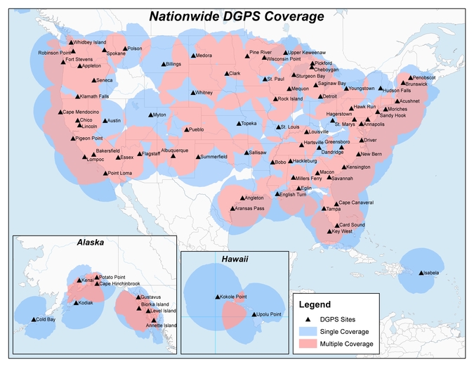
The United States Coast Guard, Department of Transportation and Army Corps of Engineers have issued a notice that reduces the number of Nationwide Differential Global Positioning System (NDGPS) sites that will be decommissioned.
The agencies published a notice on Aug. 18, 2015, seeking public comments on the proposed shutdown and decommissioning of 62 the then-existing 84 NDGPS sites.
“After a review of the comments received, we have reduced to 37 the number of NDGPS sites to be shut down, nine of which are USCG Maritime sites and 28 of which are DOT inland sites,” the notice reads. “As a result of this action, the NDGPS system will remain operational with a total of 46 USCG and USACE sites available to users in the maritime and coastal regions.”
Over time, a number of factors have contributed to the declining public use of the NDGPS, including lack of a carriage requirement, technological advances in GPS and limited availability of consumer-grade DGPS receivers.
The Federal Register Notice reduces the number of Differential GPS sites throughout the country, while maintaining coverage in major maritime ports and waterways.
Read the full notice at the Federal Register website, including a list of sites to be decommissioned. Termination of the broadcast signal is scheduled to occur within the next 30 days.
Graphic depicting NDGPS after site reductions. (U.S. Coast Guard)Graphic depicting NDGPS coverage after site reductions. (U.S. Coast Guard)Original NDGPS coverage.
KIWI PLUS, a Korean software-development company, has launched a new children’s smartwatch developed in collaboration with u-blox.
LINE Kids Watch is a tiny and colorful wearable with LINE emojis functioning as an Android-based smartwatch and officially distributed by KT Corporation. It enables precise tracking of the whereabouts of children, while also offering educational and interactive content.
LINE Kids Watch uses KIWI PLUS’ own Internet of Things (IoT) platform for wearables, KIWI Edge. Designed with a simple LCD screen for one-touch calling, it also provides real-time accurate location tracking and convenient safety zone setting. An emergency notification can easily be initiated by the child and text messages are sent by speaking into a microphone. Other features include an education quiz and a Cashbee NFC money pocket function.
“We wanted to offer accurate tracking combined with high quality cellular communication, and u-blox has already demonstrated with leading brands of children’s watches its unique combination of GNSS positioning and wireless communication technologies. And considering the small size, low power consumption and powerful location accuracy of its products as well as the speed with which they helped us solved issues, u‑blox was the right choice,” explained Sangwon Seo, CEO of KIWI PLUS.
The u-blox cellular module SARA-U270 and u-blox 7 GNSS chip UBX-G7020-KT are embedded in the smartwatch. The SARA-U270 UMTS/HSPA module provides efficient and cost-effective high-speed mobile connectivity in an ultra-small LGA form factor.
The high performance UBX-G7020 multi-GNSS chip supports GPS, GLONASS, QZSS and SBAS and delivers exceptional sensitivity and acquisition times. It has ultra low-power consumption and a very small solution footprint of 30 square millimeters.
“It was very exciting to collaborate with KIWI PLUS, as we at u-blox are committed to support our customers by combining technologies for reliable solutions,” explains Shone Kim, Country Manager of u-blox Korea. “We foresee further collaboration with KIWI PLUS in the future, using our LTE technology.”
Wearables are small portable devices that support our daily life, and deliver on-the-spot services thanks to their wireless connectivity and positioning capability. Low power technologies offer a long battery life, and with outstanding radio capabilities, a robust user experience. The market for this type of high technology integration is growing strongly, so price levels are quickly becoming competitive.
Leica Geosystems, global leader of measurement and reality capture technologies, today announced it has expanded functionality of the popular ALS80 airborne sensor that enables even more flexible data acquisition with extended range measurement capability.
The new ALS80-UP takes advantage of the proven dual-output optical system pioneered in the Leica Geosystems ALS70 and enhanced in the ALS80. The system also benefits from higher Multiple Pulse in Air (MPiA) operation settings, enabling data collection in extreme terrains with minimal variation in swath width due to terrain elevation variations.
Forest assessment using the ALS80.
The ALS80-UP works in a wide variety of scenarios, including wide-area mapping, detail mapping from high flying heights and detail mapping over mountainous terrain. With its expanded maximum range, the system has demonstrated great results at up to 6,000 meters above terrain and with terrain relief of up to 2,300 meters.
Leidos, Inc., a science and technology solutions leader in national security, health and infrastructure, worked with the ALS80-UP during testing trials. Using the enhanced lidar capabilities to improve flight crew safety when mapping in remote regions, the organization found the increased flying heights beneficial to its mission of defending digital and physical infrastructure.
“We have really put the ALS80-UP through its paces, particularly at high flying heights that are important to our clients. The system has exceeded our expectations with everything we have thrown at it, including some at double the flying height of our current missions,” said Derwin Cantrell, Leidos Geospatial Programs Division program manager. “The sensitivity and point density at altitude significantly increase mission productivity, and do so without giving up flexible performance at low flying heights.”
“We are proud to continue our commitment to extending capabilities and efficiency of the ALS product line, to help make the important work like what Leidos provides even more productive,” said John Welter, Leica Geosystems Geospatial Solutions Division president. “As our customers continue to innovate with our superior airborne sensor technology,, we are dedicated to advancing the industry and professional with new technology founded in our leading research and development.”
Terry Moore, satellite navigation professor at The University of Nottingham, has been honored with the J E D Williams Medal for his contributions to the Royal Institute of Navigation (RIN), in particular his leading role in staging its major conferences.
Moore is a longtime member of GPS World’s Editorial Advisory Board.
His Royal Highness, The Prince Philip, Duke of Edinburgh, who is patron of the Royal Institute of Navigation, will present the award to Professor Moore at the RIN Annual General Meeting on July 19 at the Royal Geographical Society in London.
“I am really surprised and delighted,” said Moore, director of the University’s Nottingham Geospatial Institute, on the news of his award. “I have been proud to serve the RIN for many years, and it is a great honor for my small contributions to be recognized in this way.”
According to the university, Moore has now received more honors from RIN in its near 70-year history than anyone else.
In 2013, Moore earned the Harold Spencer-Jones Gold Medal — the highest honor the RIN bestows — for outstanding contributions to navigation. He was also one of the youngest recipients of the esteemed award.
Moore has also won the Richey Medal for best paper to be published each year in the Journal of Navigation in 1999 and again in 2008.
In 2013, Moore was awarded Fellowship of the U.S. Institute of Navigation (ION) for his outstanding leadership of the navigation community, the establishment of GRACE (GNSS Research and Applications Centre of Excellence), the establishment of the Nottingham Geospatial Institute (NGI) and sustained contributions to the advancement of navigation and GNSS. He was the third Briton to receive ION Fellowship.
With a long and distinguished career devoted to teaching and research, Moore started at The University of Nottingham with a B.Sc. in civil engineering followed by a Ph.D. in space geodesy. He is now a leading researcher on positioning and navigation technologies and their numerous and varied applications.
He was promoted to the UK’s first chair of Satellite Navigation in 2001; he has completed numerous research projects funded by industry, research councils, the European Space Agency and the European Commission, and has supervised more than 25 Ph.D. students.
He has authored, or been a leading contributor to, more than 200 technical research papers published in top journals. This is in addition to being a major supporter of national and international GNSS conferences and both national and international professional and scientific bodies.
Moore is a Fellow of the Chartered Institution of Civil Engineering Surveyors, the Royal Astronomical Society and an Associate Fellow of the Remote Sensing and Photogrammetry Society.
Moore is a longstanding Fellow of the RIN, and currently its vice president.
The RIN is a learned society with charitable status formed in 1947. Its aims are to unite all those with an interest in any aspect of navigation in one unique body, to further the development of navigation in every sphere, and to increase public awareness of the art and science of navigation.
Measure, a United States’ commercial operator of drones, and DJI, manufacturer of unmanned aerial vehicles, are partnering to pair advanced UAV technology with operational excellence so commercial enterprise customers can achieve their most demanding business goals.
“Our partnership with DJI allows Measure to enhance technical capability and scale business operations across all verticals,” said Measure CEO Brandon Torres Declet. “This alliance will allow our companies and franchisees to be the vanguard of innovation for commercial UAV operations, using DJI’s proven technology and our experienced pilots.”
“Businesses increasingly recognize that having a knowledgeable and experienced operator at the controls is key to using UAV technology most effectively,” said Jan Gasparic, Strategic Partnerships and Business Development, DJI.
“Measure’s application-specific pilot training and deep knowledge of flight regulation allows them to set the standard for commercial UAV operations in the field,” Gasparic said. “We are looking forward to expanding our successful relationship with Measure, allowing more businesses to perform critical functions faster, safer, more efficiently and at a lower cost.”
Alongside the service collaboration, Measure and DJI will assist organizations to develop and deploy UAV operations in the fields of agriculture, energy and media. Organizations will now have a comprehensive partner to explore demanding operations such as spraying with DJI’s Agras MG-1 agricultural drone, or broadcasting live directly from a UAV to a newsroom. This partnership demonstrates Measure and DJI’s commitment to fostering a vibrant commercial ecosystem to accelerate the economic growth and innovation of the drone industry.
 MBITR2 features