Marvell, a connectivity and semiconductor company, has launched its Near Field Communication (NFC) 88NF100 Controller with Active Load Modulation (ALM) to support the smallest antenna sizes critical to mobile, IoT, wearable and automotive applications.
Adhering to the NFC Controller Interface (NCI) Technical Specification version 1.1, the 88NF100 provides an extended operating range and is extremely energy-efficient to enable extended battery life for power critical applications.
The 88NF100’s ALM technology supports the smallest antenna sizes to enable OEMs to implement NFC capabilities into small form factor designs, such as for mobile, the Internet of Things (IoT), wearable and automotive applications. The controller has extremely low power operation in polling mode to provide increased battery life for power critical applications and three single-wire protocol (SWP) interfaces to secure element (eSE) devices, for for secure payments.
The patented two-pin antenna interface supports a maximum distance of two meters between the chip and antenna, supporting devices where the antenna must be located far away from the chip, such as with automotive and printer applications, in addition to designs with tight space constraints, including smartphones and wearable devices.
Seamlessly integrating with Marvell’s Wi-Fi, Bluetooth and ZigBee solutions, the 88NF100 is compliant with the NCI Technical Specification version 1.1 to leverage existing middleware and applications and supports GSMA, ISO and EMVCo industry standards.
“As consumers demand smarter and more connected devices every year, manufacturers are increasingly faced with the challenge of incorporating advanced technology features into elegant and small form-factor designs. Marvell’s 88NF100 controller with ALM technology is designed to enable OEMs to incorporate advanced NFC technology into compact and energy-efficient designs with ultra-small antennas,” said Kevin Tang, senior director of marketing, Wireless Connectivity Business Unit at Marvell. “Marvell’s wireless technology enables the ultimate performance, battery life and operating range, making the 88NF100 ideal for NFC applications in Mobile payments, point of sale (POS) systems, Smart home connected devices, Smart watches and vehicles.”
Key features of the Marvell 88NF100 include:
Low-power consumption. The 88NF100 supports all data rates up to 848 kbps and operates with a low polling current of 60uA, making it ideally suited for power critical applications.
ALM integration. The controller’s ALM technology supports smaller antennas; and allows placement of the antenna up to two meters from the 88NF100.
Advanced digital processing for reader mode. The 88NF100’s signal processing has been optimized for better performance, enabling better reading distance in peer-to-peer (P2P) modes.
Advanced low-battery operating mode. The controller can operate on a very low current from the battery, ensuring that mobile applications deliver the same performance level in card emulation (CE) mode when the phone is powered on or off.
Compact package with low pin count. The 88NF100 has embedded wafer level ball grid array (eWLB) 2.5 x 2.5 and a compact 4 x 4 quad-flat no-leads (QFN) package.
Local Interconnect Network (LIN) interface. The LIN interface is designed to enable developers to build low cost NFC LIN nodes for the automotive industry and natively support the automotive LIN communication protocol.
Qualcomm Technologies, Tencent and Zerotech announced and demonstrated at CES 2016 a commercial drone based on the Qualcomm Snapdragon Flight platform. The Consumer Electronics Show is being held this week in Las Vegas.
Tencent, China’s largest Internet service portal, and drone maker Zerotech have co-designed Ying, a small, lightweight drone that can be easily controlled right from a smartphone, leveraging the companies’ advanced software, and the computational power of the Qualcomm Snapdragon 801 processor, making it easy to capture video that can be streamed directly to your friends using QQ and Wexin.
The Ying drone uses the Snapdragon 4K capture to “supersample” the video image, providing a stabilized, corrected video and picture recording at 1080P as well as first person view at 720p that can be directly streamed or uploaded to Tencent’s drone social community platforms Weixin and QQ. Weixin (“we chat”) is a mobile text and voice messaging communication service developed by Tencent in China, first released in January 2011.
“We continue to bring a range of new research and development products to meet the needs and demands of our customers across various industries,” said Jianjun Yang, founder of Zerotech. “We’re excited to work with two companies who are technology leaders in their space — Qualcomm Technologies who has brought their mobile expertise to the consumer drone industry, and Tencent with its popular social networks, to bring a lightweight, highly integrated consumer drone that enables users to share their photos and videos instantly with their friends.”
“The consumer drone market is expected to soar in the next few years, and Ying is a good example that shows how Tencent is working closely with the fast growing drone market by enriching use cases of our core and leading social communication services,” said Roland Cai, vice president, IEG, Tencent. “Zerotech’s expertise in UAV manufacturing and, Qualcomm Technologies’ highly integrated drone development board coupled with our social networking platforms allows us to provide our hundreds of millions of active users with a competitive price on a high quality drone such as Ying that can share their experiences in real time.”
Snapdragon Flight is a highly optimized 58 x 40 millimeter board targeted specifically for consumer drones and robotics applications. Snapdragon Flight is based on the Snapdragon 801 processor, with GPS, 4K video capture and robust connectivity, along with advanced drone software and development tools, bringing cutting-edge mobile technologies to create a new class of consumer drones.
“Consumer drones are becoming the ultimate selfie camera but with advanced capabilities such as 4K capture and high performance computing and connectivity,” said Raj Talluri, senior vice president, Qualcomm Technologies. “We are tapping into our proven mobile technologies for the exciting drone opportunity and teaming up with Zerotech and Tencent enables us to support smaller, smarter drones that deliver real-time content to China’s largest social media network.”
CES attendees can check out the Ying and other drones and robotics at the Qualcomm Technologies Booth #25824 in South Hall. Attendees can also attend the official launch event for the Ying at Zerotech’s Booth #26035 in South Hall on Jan. 7 at 11 a.m. PT.
Aman Enterprises introduces NMEA-BT — a Bluetooth iOS adapter that enables any high-precision GNSS receiver with a serial port to connect to an iPad or iPhone.
The NMEA-BT adapter is a small, weatherproof device that solves the problem of connecting non-iOS GNSS receivers and other field sensors to iOS devices. It connects to the iOS devices wirelessly using the native Bluetooth built into the iOS devices.
By replacing the iOS device’s internal GPS location information with the location information from the intrinsically more accurate external GNSS devices used by mapping and survey professionals, NMEA-BT allows users to pair external GNSS devices to their location-enabled iPhone or iPad app. The patent-pending product helps preserve the user’s investment in sub-meter and centimeter GNSS receivers and other sensors while users migrate their workforce to iOS devices.
A free app from the Apple iTunes App Store (NMEA Talker) enables the user to specify any required GPS connection parameters; connect to a local cellular RTK network (NTRIP) or a Direct IP (DIP) based correction service; and feed the corrections to the GNSS receiver, allowing for centimeter accuracy in real time in the field. The app can also be used to display error notifications like high PDOP, loss of an RTK correction, loss of satellite lock.
In addition to connecting to GNSS devices, users can connect to other sensors like laser rangefinders, resistographs, underground cable locators, and commercial weigh scales that output NMEA-formatted data.
For developers, they have full access to the entire raw NMEA stream of data from multiple devices without sacrificing app security or design architecture. No proprietary libraries are required to access the NMEA data stream.
GPS/GNSS Receiver Compatibility
The NMEA-BT has been tested with the following receivers:
John Deere StarFire
Trimble Pro 6, Geo Explorer, 372
Casel H372
Topcon HiPer series
Septentrio APS and NR series
Geneq SXBlue series
Ag Leader 6000 and 6500 series
Raven Industries – Envizio Pro series
Novatel
The only requirement to interface the NMEA-BT adapter is that the GNSS receiver must output at least the $GPGGA and $GPRMC messages via serial port.
At CES in Las Vegas, HERE unveiled the HERE HD Live Map, an advanced cloud-based map asset commercially available for vehicles today. HERE is demonstrating HD Live Map at CES: Central Plaza, Booth #CP-2.
Ready to be deployed in connected vehicles in North America and Western Europe, HD Live Map creates a highly detailed and dynamic representation of the road environment, enabling a vehicle to effectively “see around corners” beyond the reach of its on-board sensors.
HD Live Map is an integrated offering, consisting of multiple layers of data delivered in a map-tile format. It is designed to enhance both Advanced Driver Assistance Systems (ADAS) and automated driving functionality, and therefore make driving more comfortable and enjoyable.
HD Live Map includes data which tends to have high permanency, such as lane level information; data which is temporal in nature, such as road construction, traffic and accidents; and analytics data, including speed profile information that informs the vehicle about how to drive based on actual human behavior data.
With highly automated driving set to become prevalent in the next few years, the immediate next step for the automotive industry is to capitalize on the new generation of ADAS that leverages wireless network connectivity and the cloud.
With HERE HD Live Map, automakers have the ability to enhance a vehicle’s ADAS functionality — such as adaptive cruise control, adaptive headlights and curve speed warnings — by giving it access to more accurate and more reliable near real-time content and contextual information about its environment. In doing so, the industry can help drivers build the prerequisite trust and familiarity they need to feel comfortable with increasing levels of vehicle automation.
“As we move towards higher levels of vehicle automation, drivers need to feel that their car is making the right decisions on their behalf,” Floris van de Klashorst, HERE’s vice president of automotive. “When it comes to trusting your car, having consistent real-time awareness of road conditions near and far is absolutely critical. With HD Live Map serving this need, we believe it will become the car industry’s most intelligent vehicle sensor.”
Self-maintaining map. HERE HD Live Map is the first map from HERE that is self-maintaining: through multiple modes of sensor aggregation and ingestion the vehicle’s map is updated and delivered in near real-time.
For example, if vehicle sensors detected a speed limit sign which is inconsistent with what is currently in the map, the map would update accordingly so that other vehicles driving approaching the same spot have the new, correct information. This is important for ADAS functionality such as adaptive cruise control.
Similarly, if a new lane closure was reported, the map would update accordingly so that other vehicles approaching the area can already prepare to switch lanes or alternatively re-route if traffic is heavy.
HERE HD Live Map delivers connected ADAS content via layered live tiles, with dynamic traffic flow data, real-time incident reporting and speed profile data derived from rich behavior information.
HD Live Map is also data-efficient, requiring a small data footprint, with new events able to be layered on the map without the need to update the whole map itself. The small file sizes within each live tile make the delivery of highly precise data much leaner, thus reducing bandwidth requirements.
In the near-term, HD Live Map utilizes a variety of data gathered and delivered by the HERE location platform to enhance the vehicle and the driver’s awareness of what’s happening on the road.
As vehicle automation increases in the future, HD Live Map is ready to serve as an agnostic location cloud, ingesting, aggregating and delivering in near real-time ever vaster quantities of data produced by a variety of sources, especially vehicle sensors. For example, HERE is exploring further enriching its platform with new sensor data from Audi, BMW and Mercedes-Benz vehicles, which would benefit all automakers deploying HD Live Map.
HERE has already been providing either parts or full specifications of HD Live Map for automated driving testing purposes to more than ten automotive companies. Many of those have taken advantage of HD Live Map data HERE is offering of specific stretches of open road in Silicon Valley and Michigan in the United States, as well as in France, Germany and Japan.
Now, with HD Live Map offered across key regions, HERE is able to support automakers seeking to widen and deepen their automated driving development efforts. In supporting larger testbeds, HERE intends to continue to refine HD Live Map together with automakers to ensure it is optimized for their needs today and tomorrow.
“Highly-detailed map data is not only very useful but a requirement for full-featured automated and autonomous driving. In the near term, highly-detailed map data will enhance the performance and benefits of current-generation driver assist technologies; over the longer term, they will enable more effective and efficient operation of vehicles altogether by drivers or self-driving cars. Adding a feedback loop to continually gather, update and share the latest road data will further elevate the technology’s potential,” analysts at IHS Automotive said.
u-blox has released the u‑blox 8 GPS/GLONASS receiver platform. It complements the u-blox GNSS platform portfolio by addressing power sensitive usage, whereas the existing u-blox M8 platform continues to serve applications where navigation performance and highest accuracy are paramount.
u-blox 8 offers significant improvements, compared with its predecessor u-blox 7. The tracking sensitivity has been increased by 4 dBm, and is now -166 dBm.
The enhanced odometer functionality, a new geofencing feature, and optimized preset power save modes can halve the power requirements for sport products. Free-of-charge AssistNow for boosting GNSS acquisition performance, which is available online, offline or as an autonomous service, has been improved. It also makes the new positioning platform ideal for all battery powered devices, especially wearables and sports tracking.
“Nowadays many portable applications rely on a single coin battery; hence low power-spending is crucial,” said Uffe Pless, Product Marketing and Positioning, u‑blox. “u‑blox 8 has been developed for wearables and tracking applications, keeping in mind the need for low power consumption without compromising performance.”
u‑blox 8 is pin-compatible with u‑blox 7. It will be available as a chip and as modules in several form factors. Customer samples of u‑blox 8 chips and modules will be available by Q2 2016.
GNSS receiver maker Septentrio has announced the availability of its geographical information systems (GIS) PinPoint-GIS on the ArcGIS Marketplace.
PinPoint-GIS was developed to enable straightforward GIS data collection without the need for expensive additional software linking a GNSS receiver with the Esri ArcGIS Platform
PinPoint-GIS helps ArcGIS users make informed and timely decisions, Septentrio said. It turns GNSS data collected by Septentrio’s receivers such as the Altus NR2, Altus GeoPod and the AsteRx-U into actionable GIS data. Height and other project parameters are available directly in the ArcGIS workflow without any additional steps by the user.
Pinpoint GIS makes ArcGIS easily accessible through existing hardware — consumer commercial and ruggedized device, tablet or even smartphone — regardless of operating system. PinPoint-GIS Web makes ArcGIS available from a standard web browser or from an Android app, downloadable from Google Play.
The Android app works with Esri’s Collector for ArcGIS and provides an accuracy widget which confirms horizontal and vertical accuracy in a highly visible way. This brings the user the immediate security that the captured data meets the required accuracy in both the horizontal and vertical.
“Integrating ArcGIS functionality into PinPoint-GIS empowers ArcGIS Online users,” said Gustavo Lopez, PinPoint-GIS Product Manager. “With the click of a button, a PinPoint-GIS user can turn accurate and reliable GIS data collected from their Septentrio GNSS receiver into actionable data needed for smarter decisions, effective analysis and customized maps all within the easy-to-use ArcGIS.”
The Federal Aviation Administration’s (FAA) drone app — B4UFLY — is being released for Apple, following an initial beta testing period. The app can be dowloaded from the Apple store.
The FAA also is releasing a beta version of B4UFLY for Android devices, which can be downloaded from Google.
B4UFLY tells users about current or upcoming requirements and restrictions in areas of the National Airspace System (NAS) where they may want to operate their unmanned aircraft system (UAS).
“We expect B4UFLY will help raise public awareness about what it means to operate unmanned aircraft safely,” FAA Administrator Michael Huerta said at the Consumer Electronics Show in Las Vegas. “It is another important part of our education and awareness efforts to foster a culture of safety and accountability for the UAS community.”
The B4UFLY app includes a number of enhancements the FAA developed as a result of user feedback during the beta testing announced in May 2015. Within two taps, users know if it is safe to fly at their current location. The app provides a status indicator that tells users: “Proceed with Caution,” “Warning – Action Required,” or “Flight Prohibited.”
The app also features a planner mode that allows users to select a different time and location for an upcoming flight and determine if there are any restrictions at that place and time.
By law, hobbyists who want to fly within five miles of an airport must notify the airport operator and the air traffic control facility (if there is one) prior to flying.
For now, B4UFLY will ask users who are supposed to notify the airport before flying for voluntary information about their planned flight. This will not meet the statutory requirement to notify the airport and air traffic control facility, but the data will help the agency make informed policy decisions related to notification. This information will not be publicly available.
You can find more information on our B4UFLY webpage.
By 50th Space Wing Public Affairs, Schriever Air Force Base
Throughout the years, GPS has achieved historic milestones and garnered recognition for its contributions to the betterment of humanity.
2015 was no different.
Photo: 50th Space Wing Public Affairs, Schriever Air Force Base
GPS, operated by the dedicated men and women of the 2nd and 19th Space Operations Squadrons at Schriever Air Force Base, Colorado, is also the world’s largest military satellite constellation. Uses of GPS include precise timing for financial transactions, search and rescue, communications, farming, recreation and both military and commercial aviation.
The 2 and 19 SOPS, referred to as Team Black Jack, hosted GPS Week Feb. 15-20 to honor their heritage and interact directly with the Colorado Springs community. The week included a community geo-caching event, GPS/base tours for dozens of middle and high school students, 2 SOPS educational outreach events at local schools and culminated with a GPS heritage celebration.
“We wanted to touch the different facets of our community and that’s why we planned these events,” said Tech. Sgt. Abifarin Scott, 2 SOPS GPS maintenance flight chief.
GPS received historic recognition from the city of Colorado Springs a few months later.
Colorado Springs City Council members presented a proclamation declaring July 17, 2015, GPS Day during a ceremony July 15.
“It’s a great time, a significant milestone that [GPS] has been active this long,” said Andy Pico, Colorado Springs City Council member. “GPS has grown to be such a tremendous part of everybody’s lives, it runs everything…it’s so much into the fabric of everybody’s life.”
The proclamation came as the Air Force celebrated GPS’s 20 years of full operational capability, confirmed July 17, 1995. During the last 20 years, GPS has become an integral part of technology that affects the lives of billions of people around the world.
The men and women of GPS stayed busy supporting many operations throughout the year.
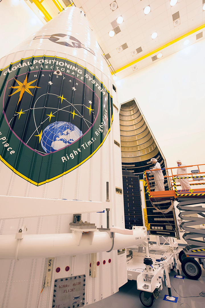
GPS IIF-10. (Photo: ULA)
The Air Force and the 45th Space Wing supported the successful launch of a United Launch Alliance Delta IV rocket that roared to life March 25, carrying the Air Force’s ninth Block IIF-09 navigation satellite for the GPS.
2 and 19 SOPS accepted satellite control authority of GPS IIF-9 Satellite Vehicle Number-71 April 3.
2 SOPS successfully completed a transfer operation of GPS satellite control authority to the Alternate Master Control Site at a backup location on June 6.
2 and 19 SOPS accepted command and control of the 10th GPS Block IIF satellite July 24.
After 15 years of launch operations for the GPS, 19 SOPS completed their 26th launch as a squadron Oct. 31, performing checkout operations on the 11th GPS IIF satellite.
On Nov. 6, Team Black Jack accepted SCA just six days after the Halloween launch of satellite vehicle number-73 – in record time. Members of Team Black Jack prepped for the launch and subsequent SCA acceptance of SVN-73 for approximately three months.
The Command’s GPS operations were showcased in multiple venues this year, engaging with communities and making the mission known all over the world.
CBS featured the 50th Space Wing and GPS on an episode of 60 Minutes, and BLUE, the Air Force’s flagship TV show, also featured GPS — both of which displayed the capabilities it offers to humanity.
Beyond its essential capability for the military, GPS is a worldwide utility that provides the highest accuracy data available to people all around the world and enables such vital activities as weather forecasting, transportation, global commerce and farming/agriculture.
“2 SOPS’s continuing objective is to ensure GPS remains the gold standard for global space-based navigation and timing by providing highly reliable and accurate GPS signals to users around the world,” said Lt. Col. Todd Benson, 2 SOPS Commander. “We look forward to continuing to provide our mission partners and global users with the most accurate position, navigation and timing signal available in the history of GPS.”
Broadcom Corporation has added a new GNSS wireless connectivity chip to its automotive portfolio, which it unveiled at CES 2016, being held this week in Las Vegas.
Automotive GPS shipments are expected to more than double by 2022, creating significant opportunities among component suppliers and increasing competition for market share. The chip offers wideband capture radio technology for simultaneous tri-band reception of all visible GNSS satellites including GPS, Galileo, QZSS, GLONASS, BeiDou and global SBAS augmentation systems.
Broadcom’s BCM89774 provides improved location and positioning while lowering power consumption for in-vehicle applications and reduces bill of materials cost for car makers, by integrating the sensor hub and CPU on a single chip.
The BCM89774 delivers original equipment manufacturers (OEMs) one of the most accurate solutions available today, Broadcom said. The new chip also improves positioning in dense urban environments and foliage-blocked areas to enhance the consumer experience.
Optimized to meet the rigorous standards of the automotive industry, the BCM89774 has been tested to AECQ100 automotive environmental stress requirements, is manufactured in TS16949 certified facilities, and offers full production part approval process (PPAP) support.
“Broadcom’s new GNSS connectivity chip for automotive keeps car makers and tier one suppliers ahead of the curve with advanced precision and reduced power consumption while lowering BOM cost,” said Richard Barrett, Broadcom Director of Automotive Wireless Connectivity. “By delivering premium products that meet automotive grade requirements, we are positioned for growth in this accelerating market.”
Key Features:
Low-power mode for emergency service and theft tracking applications
Location awareness capabilities added to traditional functions of a sensor hub for lower power consumption and BOM costs
Simultaneous reception of GPS, GLONASS, BDS, QZSS and Galileo navigation satellites
Support for global Satellite Based Augmentation System (SBAS) system
Management of CAN BUS inputs and sensors such as accelerometers, gyroscopes, and magnetometers to provide a fused sensor data tracking subsystem
Best-in-class acquisition, tracking sensitivity and time-to-first-fix in both cold and hot starts
Full pass through capability for external host-based systems
Tested to AECQ100 automotive environmental stress requirements and manufactured in TS16949 certified facilities
Full production part approval process (PPAP) support
Qualcomm Technologies has introduced its latest Qualcomm Snapdragon automotive processors, the Snapdragon 820 Automotive family, offering a scalable next-generation infotainment, graphics and multimedia platform with machine intelligence and a version with integrated LTE (long-term evolution)-Advanced connectivity.
The Snapdragon 820A is Qualcomm Technologies’ newest automotive-grade system-on-chip (SoC). Qualcomm Technologies has taken a modular approach to designing the Snapdragon 820A, enabling a vehicle’s infotainment system to be upgradable through both hardware and software updates, thereby enabling vehicles to be easily upgraded with the latest technology.
The Snapdragon 820A’s sensor integration provides cognitive awareness and vehicle self-diagnostics, supports ADAS features for improved vehicle safety systems, and provides location and navigation through GNSS and dead-reckoning technologies.
Qualcomm Technologies is demonstrating the upgradeable module at the Qualcomm Automotive booth, North Hall #915, at CES 2016, being held in Las Vegas this week.
The Snapdragon 820A family is based on 14-nm FinFET advanced process node running Qualcomm Technologies’ custom 64-bit Qualcomm Kryo CPU, Qualcomm Adreno 530 GPU, Qualcomm Hexagon 680 DSP with Hexagon Vector eXtension (HVX), Qualcomm Zeroth machine intelligence platform, and the Snapdragon 820Am version with integrated X12 LTE modem capable of 600 Mbps downlink/150 Mbps uplink. The 820A is engineered with custom-built, highly optimized cores designed for heterogeneous computing — the ability to combine its diverse processing engines within the SoC, such as the CPU, GPU and DSP cores, to achieve previously unattainable performance and power savings.
The Zeroth initiative, a machine intelligence platform on Snapdragon 820A, is designed to enable automakers to develop state-of-the-art deep learning-based solutions using neural networks for advanced driver assistance systems (ADAS) and in-vehicle infotainment scenarios, and run them efficiently on embedded platforms in the vehicle. Zeroth accelerates execution of deep neural networks using the heterogeneous compute engines that are part of the Snapdragon 820A. A Zeroth-powered development kit for automotive solutions will be available for the Snapdragon 820A.
“With the Snapdragon 820 Automotive processing platform, we are delivering an unprecedented level of performance and technology integration designed to significantly enhance the consumer’s safety and in-vehicle experience. Never before has the unparalleled combination of integrated LTE cloud connectivity, powerful heterogeneous computing, leading-edge multimedia performance and breakthrough machine learning capabilities been delivered in a single chip, fully integrated, automotive grade solution,” said Patrick Little, senior vice president and general manager, automotive, Qualcomm Technologies.
“The automotive industry has long been asking for a single scalable solution capable of delivering the rich user experience and level of performance, connectivity and upgradability that consumers are accustomed to on their personal mobile devices,” Little said, “including real-time cloud connectivity and navigation, immersive 4K graphics and video displays, the flexibility of hardware and software upgradability, and the deep learning and remote diagnostic capabilities needed to deliver the next level of safety performance in the vehicle. The Snapdragon 820 Automotive platform has been designed to deliver all of these capabilities and much more.”
The version with integrated X12 LTE modem is designed to support continuous in-car and cellular connectivity, featuring the leading 4G LTE Advanced Pro that can support up to 600 Mbps download/150Mbps upload speeds, stream HD movies into the car, serve as a Wi-Fi hotspot supporting 802.11ac 2×2 MIMO, connect multiple mobile devices inside the car, and support 802.11p DSRC for V2X (vehicle to vehicle/infrastructure/pedestrian) communications. Local connectivity inside the car via Bluetooth supports content sharing between mobile devices brought into the car and the car’s infotainment system.
Qualcomm Technologies is also helping to lead the 3GPP in developing specifications for automotive V2X, for both LTE release 14 (LTE V2X) and 5G standards.
“Like Qualcomm Technologies, AT&T is committed to the connected car and takes a similar approach to technology development with the AT&T Drive platform, offering a global, modular solution to automakers to enable best-in-class user experiences for their drivers,” said Chris Penrose, senior vice president, Internet of Things, AT&T Mobility. “We design our solutions to provide better connectivity, flexibility and upgradability on our network, and Qualcomm Technologies’ development of the Snapdragon 820A Smart LTE Module is a prime example of this same approach to technology.”
By integrating advanced camera and sensor processing, the 820A supports critical always-on warnings and emergency services, extends standard cameras to Intelligent Cameras, and supports parking assist periphery vision features using surround view cameras. These features are supported by the on-chip Hexagon 680 DSP with HVX, which supports multiple automotive camera sensors connected simultaneously.
The Snapdragon 820A family of automotive-grade processors is designed for the automotive ecosystem and offers these features:
Scalable and modular platform offering pin, package and software-compatibility, with optional integrated LTE capability that is hardware and software upgradeable as wireless network technology evolves.
Supports vertical tiering options by offering the Snapdragon 820A family across premium to standard performance configurations.
Comprehensive software support for QNX, Linux and Android, as well as substantial platform-level integration of high value sub-systems to respond to the acceleration in refresh cycles while managing cost.
The connectivity, multimedia and graphics capabilities allow many real-time cloud based features, including streaming multimedia, enterprise collaboration, real-time maps and location services, remote diagnostics and one-touch telematics, with substantial potential for performance, connectivity and multimedia innovation for auto OEMs.
The upgradability option allows a wireless operator to offer an 820A Smart LTE Module concept for the version with an integrated modem that allows cellular connectivity to be updated through both hardware and software when new features become available on the cellular network.
Qualcomm Technologies is also collaborating with Aisin AW to develop the modular infotainment solution utilizing the Snapdragon 820A. “We expect the 820’s powerful features will deliver superior processing power, graphics performance and low power consumption demanded by next generation infotainment systems,” said Kyomi Morimoto, managing officer, Aisin AW.
Automotive samples of the 820A family are expected to be available in the first quarter of 2016. A number of concept vehicles and demonstrations based on the Snapdragon 820A, from Qualcomm Technologies and other automotive industry leaders, will be shown in the Qualcomm Automotive booth, North Hall #915 at CES 2016.
Bosch Sensortec is unveiling new generations of intelligent accelerometers and high-performance gyroscopes at the 2016 International CES in Las Vegas.
Aimed at smartphones, tablets and wearables, the new devices cover a wide range of requirements, from low-power consumption for always-on applications such as step counting, to high-performance optical image stabilization (OIS).
Intelligent three-axis accelerometers — BMA422 and BMA455
Today’s applications running on modern mobile devices place many demands on motion sensors. These sensors are required to continuously sense motion, such as for step counting operations, while at the same time delivering a high level of performance without compromising battery lifetime.
To meet these challenges, the new sensors from Bosch Sensortec integrate embedded intelligence functionality into standalone accelerometers. Adding intelligent features to an accelerometer enables innovative applications, while minimizing power consumption by eliminating the need to wake up an application processor or an additional discrete sensor hub. Overall system power management and user experience can be improved by the accelerometer detecting and processing motions such as glance, pick-up and tilt.
Current consumption of the new accelerometers is kept very low to extend battery life. The integrated Android 6.0 “Marshmallow” features minimize programming effort for customers. Each device delivers outstanding accelerometer performance for low offset, low temperature coefficient offset (TCO) and low noise levels, the company said.
Two new accelerometers are being launched: the BMA422 “all-rounder” is suitable for standard applications, and the BMA455 provides high performance for gaming and immersive activity tracking. In addition, the high level of performance enables demanding applications covering augmented reality, virtual reality, image stabilization and industrial measurement applications such as spirit leveling and inclination measurement.
High-performance gyroscopes — BMG250 and BMG280
Mobile devices require gyroscopes for many applications, including gaming, augmented reality, virtual reality and OIS. To provide the necessary performance, Bosch Sensortec’s new gyroscopes combine the most important parameters in a single device: low noise, low TCO and high bias stability.
Although delivering high performance, they do both feature the lowest power consumption of any standalone gyroscope in the market, thus helping to extend battery lifetime in mobile devices.
Today’s announcement includes two three-axis gyroscopes: the BMG250 provides low noise, low TCO and high bias stability, while the BMG280 delivers ultra-low noise optimized for OIS and includes a secondary interface for OIS, making it fit for use in camera modules. The BMG280’s secondary interface can be used in parallel with the primary user application interface, for example for simultaneous panorama creation and OIS.
Packages and availability
The new devices are provided in small packages. The BMA422 measures 2.0 x 2.0 x 0.95 mm³, while the BMA455 is 2.0 x 2.0 x 0.65 mm³. The BMG250 and BMG280 gyroscopes both measure 3.0 x 2.5 x 0.83 mm³.
Samples of the all sensors are available now, with mass production of the gyroscopes to commence in Q1 2016 and mass production of the accelerometers starting in mid-2016. For pricing, contact Bosch Sensortec.
Bluvision, a real-time location services (RTLS) provider, will be demonstrating its RTLS solution along with Texas Instruments (TI) at CES 2016.
Bluvision’s location algorithms “continue to redefine how technology can be used for indoor location,” the company stated in a news release. Its RTLS solution uses Bluetooth low-energy and Wi-Fi technology to determine specific positioning, leveraging multiple techniques, including smart machine learning algorithms for accuracy.
The combination of Bluetooth Smart, Wi-Fi and sophisticated algorithms on the cloud allows tracking and monitoring of assets — equipment or people — without the need for a smartphone application and uses minimum hardware that is fast and easy to implement, Bluvision said.
Bluvision’s RTLS solution is accurate down to three feet even in harsh conditions. It can be deployed in a large area within hours. The solution supports creating multiple alerts and policies, including creating multiple virtual geofences that trigger alerts when entering or leaving pre-defined areas.
Bluvision will demonstrate the RTLS solution in the TI Village (#N115-N118) at CES 2016, using TI’s SimpleLink Bluetooth Smart CC2640 wireless microcontroller (MCU).
“Our LBS (location-based service) solution is disruptive,” said Jimmy Buchheim, CEO of Bluvision. “Using TI’s SimpleLink CC2640 wireless MCUs with built-in SDR (software-defined radio) and the combination of our talented data scientists, advanced algorithms team and cloud team, allows us to revolutionize indoor location, achieving what is considered impossible accuracy for Bluetooth-based technology.”
For more information on the demo or Bluvision’s RTLS solution, contact Subhashree Sukhu.