The September article Receiver Design for the Future is based on a GPS World webinar, which sprang from a presentation at the Stanford PNT Symposium. Listener questions and Greg Turetzky’s answers during the webinar are provided below. Greg Turetzky is a principal engineer at Intel responsible for strategic business development in Intel’s Wireless Communication Group focusing on location. He has more than 25 years of experience in the GNSS industry at JHU-APL, Stanford Telecom, Trimble, SiRF and CSR.
Is dual frequency expected to be seen in smartphones this year?
If what you’re saying there is L1, L2, L5, the answer is absolutely not. But if what you’re saying is GPS, Galileo, BeiDou, which are all in different bands, then I think we are already seeing tri-bands between the GLONASS band, the GPS band and the BeiDou band. I expect to see that continue from a multi-constellation standpoint, rather than multi-frequency on individual constellations.
How do you see antenna design changing and developing relative to receiver design?
If you go back to that slide, the answer is the opposite — antenna design has been getting worse and worse in order to shave cost and size and is being made up for in silicon design. A really good example is, most GPS receivers that we build for mobile phones aren’t optimized to work at -140 dBm, our standard normal outdoor power, because we never see that. The antennas that we typically work with are 8, 10, 12 dB down, so no matter what, we never see anything above -140.
So I think the answer is the opposite — no one is trying in my market to make better antenna design, they’re trying to make them even smaller and even cheaper. Especially if you think about getting into wearables and button-sized things, you need a GPS antenna, a Bluetooth antenna and a Wi-Fi antenna in a button. That’s the problem, and still leaving room for performance. So basically we’re being asked to make up for that in the receiver design.
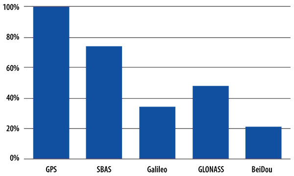
One of your slides showed GPS with 100% penetration, and SBAS was one of the next highest bars on that chart, outdated as it was, even though it’s only less than a year old. What are the benefits of SBAS in a commercial receiver?
The issue with that fact is we like geostationary satellites, because they’re easy to find and they’re useful from a visibility standpoint. But the data demodulation of those is even more challenging than GPS because of the additional coding schemes that go on top of it. It’s very difficult for us to demodulate off the SBAS satellite, so we primarily use them for ranging and for autonomous operation when we’re not aided.
In aided operation, we use them less, because we get the data that we need off the Internet, right off a feed, or it comes in off of a satellite, which is much more useful. So SBAS stuff is there because it doesn’t add a lot of cost of difficulty to the receiver design, but it’s not a crucial part of the operation anymore — I’d say with the exception of QZSS, which has a large impact in its regional operating area.
Let’s continue the trend in questions towards multi-constellations. What’s the strategy to switch on another GNSS constellation in case of a GPS problem for a future receiver?
It’s a really good question, but it comes from a premise that we would switch something on that was normally off. The general strategy that’s being followed is to use everything that’s available all the time, so that we can use the methodologies of essentially autonomous RAIM on a receiver where we now have 8, 10, 12 signals coming into the receiver. It’s pretty obvious right away when something has gone wrong, and so it’s not so much time when we can flag when to switch on. It’s more a time when we can switch off. If we see a systemic problem in multiple satellites, then we may use that in our definition, but it’s not from a switching-on standpoint.
So, basically what we’re doing is we’re keeping everything on all the time and relying on autonomous RAIM capabilities from the fact that we’re tracking 14 or 16 satellites at a time with all this extra compute horsepower, because now I’m running embedded CPUs at hundreds of megahertz, where back at SiRF when we could get 15 megahertz, we were happy. So we have a lot more compute horsepower on the mobile side to do autonomous RAIM.
How the Internet of Things Now Drives Location Technology
The number of devices connecting to the Internet is growing fast. The applications running on them require location context to determine the most likely use case. These devices need continuous location — not necessarily noticed or activated by the user, but always on. The specification that becomes important is energy per day: the device must maintain its location without draining its battery — and increase location availability indoors. That creates new design requirements for hybrid capability.
By Greg Turetzky
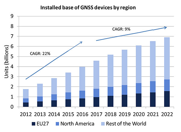
A lot of people have the opinion that the GNSS market is kind of flat. Actually, several different market studies would indicate that it’s not as flat as you would think. See FIGURE 2, taken from the European GNSS Agency’s (GSA’s) 2015 GNSS Market Report. The growth rate certainly is slowing, but any market that continues to grow at a 9 percent annual growth rate is a very nice target area. As you can see, the GSA expects that we’re going to have somewhere in the neighborhood of 7 billion devices within the next eight to ten years.
Figure 2. Installed base of GNSS devices by region; the GNSS market continues to grow at a rapid pace. Source: GSA GNSS Market Report.
We’re getting to the point where the number of GNSS receivers exceeds the population of the planet, which makes for an interesting thought process as to where GNSS is going to end up, and how it’s going to have to end up in everything that we do. That makes for a nice market opportunity. A big reason for that is we’ve seen a lot of growth in demand for multi-constellation GNSS. Everything pretty much has GPS in it that everyone terms as GNSS, but the growth of these other constellations is happening relatively quickly.
FIGURE 3, in my opinion, is already significantly out of date, even though it is less than a year old. Other market estimates indicate that GLONASS penetration into receivers, especially in the mobile phone field, is closer to 70 or 80 percent today, and that is expected to grow. There’s really no technical or economic reason why GNSS receivers can’t support multiple constellations, even at the consumer mobile device level.
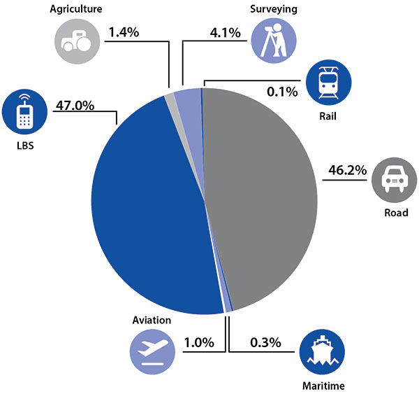
Once all those constellations are in place, let’s look at where those receivers are going from a market standpoint. FIGURE 4 is divided by revenue, which is an interesting way to do it because we all know if you divided it by actual units, then the location-based services (LBS) portions in phones would dominate everything; everything else would just be a sliver that wouldn’t be visible. But if you look at it from a revenue standpoint, there are still many revenue opportunities in the phone segment and in the automotive segment.
Another reason to expect continued market growth is, if you examine Figure 4, you’ll notice that the Internet of Things (IoT) category (see SIDEBAR) doesn’t even show up here. We’ll see going forward that there will be a new slice of pie showing a focus on that segment and those types of applications.
Intel and the Internet of Things
Intel’s mission is no longer only to build PCs. We’re about bringing smart, connected devices to everyone. That encompasses a range of products, and we’ve been expanding our portfolio appropriately.
We start with everything from big iron data centers (which are part of smart devices) to mobile clients and all the way down to the Internet of Things (IoT) and wearable devices. All those devices are part of this smart connected world. Our group’s job is to help on the connectivity side, which varies by product.
This whole idea expands beyond mobile phones and into the IoT, a big trend whose methodology is transforming business, starting at sensors all the way up to big data, to make interesting decisions. The number of devices that are being able to connect to the Internet is growing faster than anybody can keep up with, and that creates a really interesting opportunity. That gives you a bit of a picture as to why Intel is interested in this market and where you’re going to see us playing.
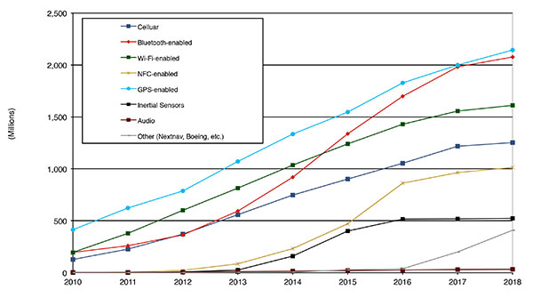
Looking at how we provide this location capability beyond just GNSS, how are people determining their location in these different platforms, and what are the different technologies available? FIGURE 5 shows that in 2014–2015 the most popular technology is still GPS, but there is a fast-growing trend in both Bluetooth-enabled and Wi-Fi-enabled penetration of location technology. Both of these are more suited to indoor operation, where the market is still in its early stages.
Figure 5. Alternative location technology shipments, world market forecast: 2010–2018. Source: ABI Location Technologies Market Data.
Although GNSS continues to grow with market growth, the growth of other technologies and the ability to incorporate them into location solutions is growing pretty quickly, and the radio versions of those are, in general, growing the fastest, followed by the inertial sensors. I think we’re going to see this combination of location technologies, jointly providing a single answer, becoming the norm in mobile products.
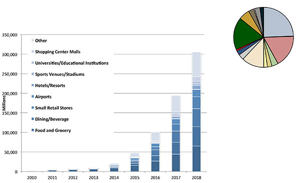
These technologies are going to end up, especially for indoors, in different areas. FIGURE 6 shows a huge growth, not only growth but segmentation among a bunch of different types of venues, all of which seem to be adopting an indoor location methodology. Not all of them will adopt the same one, but all these types of venues are looking at that market and are looking at potential different technologies to serve their needs. What might be most appropriate in a grocery store — geared towards finding a particular item — like a Bluetooth beacon might be less interesting in an airport, where there’s still a need for navigation from place to place, where proximity is not necessarily the right answer.
Figure 6. Indoor location technology installations by vertical market, world market forecast, 2010–2018. Source: ABI.
We see a large growth of a very disparate technology base; at the right of the figure is a pie chart where I had to remove all the callouts, the list of all the different technology suppliers addressing these particular indoor markets. What you see is a highly fragmented supplier base; that’s very consistent with an early market implementation. There’s a lot of different people attempting to get into this market with a lot of different solutions. This is pretty classic for an early-adopter scenario.
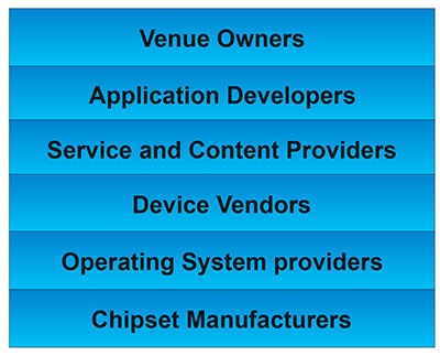
The Stack. Changing accuracy requirements will come up a bit later in this article. Once we’ve looked at where those different venues are from a requirements standpoint, we start to look at the types of companies that are trying to participate in the ecosystem required to do that (FIGURE 7). If you start from the bottom, where I live as a chipset manufacturer, and you move up the chain, you see seven different layers of people in the creation of a location to the end user, especially indoors. And every single person you see in this value chain is trying to make money.
Figure 7. LBS value chain: a highly complex ecosystem with each segment looking to differentiate and monetize indoor location. Source: GSA GNSS Market Report.
That’s the crux of the issue: a lot of people want a piece of that pie, and all of them have a relevant part to play, but when seven people in the stack are all trying to own the location result in order to monetize it, it becomes difficult to create a unified methodology. I live at the bottom of this complex ecosystem, in the technology implementation layer. Getting dollars to flow from the top to the bottom gets relatively difficult, so we are very driven to bring cost competitiveness into this market.
In summary, from a market standpoint, we see that the market opportunity is very big and still growing. This makes it interesting to a company like Intel, even though we aren’t a major player in the business today, to continue to invest in it. We see a trend going from GPS to GNSS and on to location, and now the big opportunity is indoor location. But this indoor-location market is not a stand-alone device opportunity. Indoor location requires this kind of technology inside other devices, inside phones and tablets and IoT types of things.
Context. Let’s look at indoor location as a feature in a larger portion of product. That idea comes from the requirement for location not just for the location itself, but in order to provide context. That’s critical because now these smart, mobile devices are not just used to make phone calls, but are used all the time. As a result, many applications running on them really require that location context to determine the most likely use case that the device is currently operating, making the consumer experience easier and more natural. This is evident throughout the entire value chain from phones and tablets to wearables. If you think about that from a requirement standpoint, you see the major places where GNSS has enabled trend changes in the market.
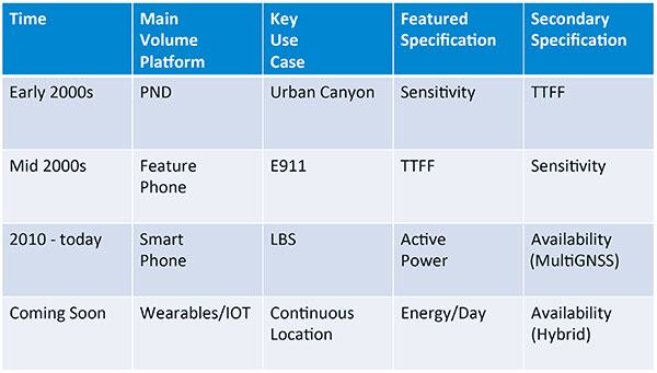
Let’s step back a bit in history to go through FIGURE 1, the opening figure, horizontally. In the early 2000s when I was at SiRF Technology, the main market drivers were personal navigation devices (PNDs). There were all these dashboard-mounted PNDs, and the main things we were trying to fix was the urban-canyon problem. GPS always worked well in the rural areas but always had trouble in urban canyons; to fix that, we had to improve the sensitivity. The solution in that timeframe was with multi-correlator designs and improved RF frontends; we were able to improve the sensitivity of the receivers by a good 5–10 dB, which enabled us to really keep the antennas inside the car so that there was no need for roof-mounted antennas. The PND could be mounted on the dash and work just fine. That was a big factor in improving the user experience. The secondary specification that enabled that market to grow quickly was time-to-first-fix; those devices had to power-up and work fast to prevent user frustration.
Within about five years, however, the PND market was overtaken by growth in the feature phone market. The reason for that was the FCC E911 mandate; everyone had to figure out a way to make sure that phones sold in the United States had the ability to meet that 911 mandate. GPS was one of the major methodologies in meeting that, and the main driver there was not around sensitivity, it was improving first-fix times. The mandate required a 30-second TTFF implementation in a very challenged environment to support emergency-services dispatch. This led us to the development of assisted GPS (AGPS) and further integration into phones. We had a secondary requirement of continuing to improve the sensitivity, because now we had to deal with an even worse antenna in a handset.
Once that was taken care of in the mid 2000s, the next thing we saw coming — and what’s coming now — is the change in GPS requirements for smartphone navigation. This comes from the huge growth of higher end smartphones that are running multiple applications driving the use-cases around LBS. How will the location be used to provide services, now that we can provide applications on that platform? Now the most important specification has become active power? Every time a GPS receiver is turned on for use in an LBS mode, you have to make sure that the power consumption is kept to a minimum, or no one will use those services. So the active power of the device became a very important specification that we were all trying to improve.
The secondary specification we had to improve was the availability. This is where the advantage of multi-GNSS started to show up — using handsets for car navigation on Google map types of implementations. So the performance of smartphone navigation in the urban canyon became a big driver recently as the main use case.
Impacts of New Requirements on Silicon Design
Standby power reduction impacts
SRAM is the leakiest component of typical design
Needs to be reduced or ideally eliminated
Non-continuous fix methods
Ability to quickly save and restore state information
Hybrid location solutions
Support measurements from multiple radios
Need to share radios, not duplicate chains
Increased integration of of multiple radios on single die
Need more interference rejection capability
Ability to support concurrent radio operation on single die
Next! What’s coming next is the idea that these wearables and IoT platforms are not just doing LBS on demand because of the currently active application. They are going to need continuous location. The device needs to provide location capability all the time, but it’s not necessarily going to be noticed by the user or activated by the user, so the specification that becomes important is energy per day. You want to make sure your device can maintain its location without draining its battery. Then we are also going to have to increase the availability of location into indoors to really fix this whole problem. And that will really move us into hybrid capability.
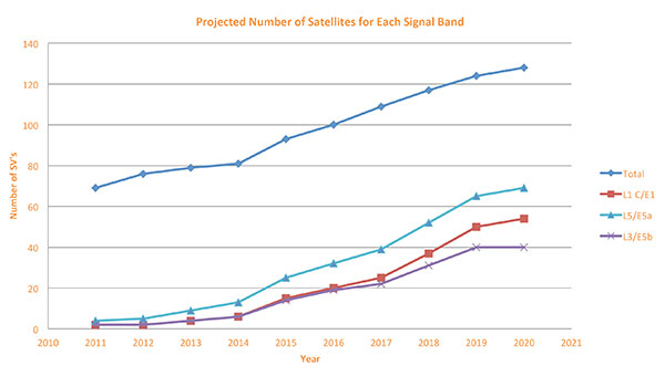
If we look at those changes in the market and we look at how they’re going to impact the GNSS architecture, the first thing we want to look at is: Where is GNSS? FIGURE 8 is a plot that I’m sure everybody has and is hard to keep up to date. It looks at the satellites coming from the different satellite constellations. The important thing here is that we are approaching a timeframe where a significant uptick in the growth of satellites can send the numbers over 100. That can really have an impact on receiver design, if you’re building a multi-GNSS receiver and you have to deal with a hundred satellites. How are you going to do that?
Figure 8. Projected number of satellites for each signal band.
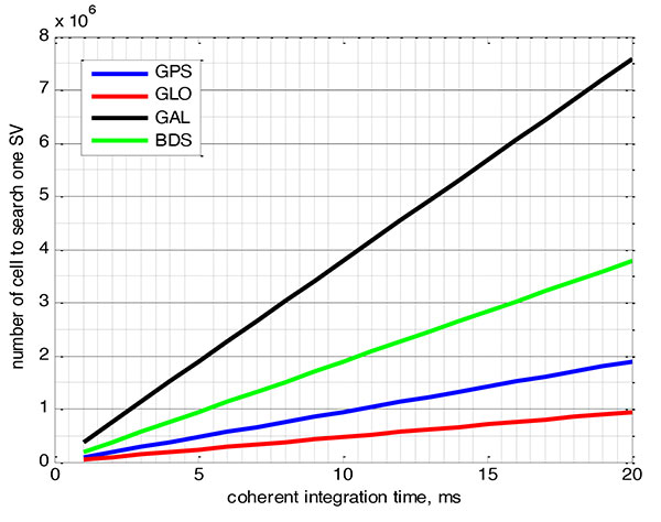
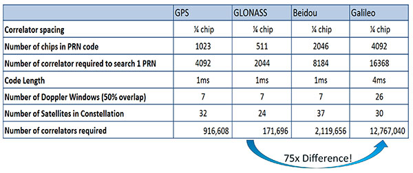
FIGURE 9 shows the relationship between the coherent period and the number of correlators required to search for one satellite in each constellation. We looked at particular scenarios — in this case, let’s say we are trying to do an outdoor location, so –130 dBm cold start test (FIGURE 10) with an initial frequency certainty of around 1 part per million (ppm). We wanted to look at the impact of the different constellations on doing that, and what it takes inside of the receiver to implement it. I’m not going to go into great detail here. But looking at those impacts in correlator counts, you can see the difference between building a GPS receiver that can do this and building a Galileo receiver that can do this. From the simplest one, that is, GLONASS, and from the most difficult one, which is Galileo, you see a 75x difference in the number of correlators required to do that, based on signal structure. This would indicate that, maybe from a cold start fix point of view, you might prefer a GLONASS implementation, and do GPS or Galileo later.
Figure 9. Relationship between the coherent period and number of correlators requried to search for one satellite in each constellation. ±1 ppm local oscillator frequency uncertainty; ±10 kHz Doppler shift range; 50 percent Doppler bin overlap; 1/4-chip correlator spacing.Figure 10. Test scenarios, cold start test.
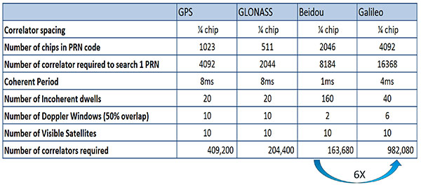
If that specification was your primary concern, then you would look at how those requirements got implemented into those devices. In addition, you try to come down to these low levels of power consumption, maintain sufficient accuracy to support these applications, and be able to move this into a very small form factor. If we look at the relationship between the number of correlators required to search for each satellite and amount of silicon area that requires, we see a big difference in the growth of those, depending on which constellation you look at. But if you look at a hot start scenario (FIGURE 11) rather than a cold start and at a weaker signal level, which is the more common implementation in devices today, you see a different result. With an improved starting condition because we have better information on the oscillators and reduced other uncertainties producing a smaller search space, the silicon area impact is greatly reduced. Then we have to really look at reducing standby power. That means we need to look at static random-access memory (SRAM) because SRAMs are a horribly leaky component and create very large standby power, but they are what we’ve been using for years in the standalone GPS world.
Figure 11. Test scenarios, hot start test.
We also have to look at non-continuous fix methodologies: this idea of turning things on and off to save power, which relates back to the standby power issues. We also have to look at hybrids: How are we going to support measurements from multiple radios like Wi-Fi and Bluetooth that are becoming important for indoor location? How are we going to share those radios without just pasting them together? That involves integration onto single die, and looking at what happens on the silicon level, and at what happens when you try to run radios at the same time.
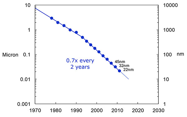
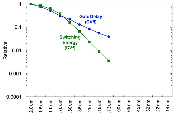
What we have to work with, especially here at Intel, the home of Gordon Moore, is Moore’s Law. It is still working 30 years after it was proposed. Recently, we see that we are tracking this progression of constantly reducing device sizes and moving forward. The dates in FIGURE 12 are for the process technology nodes associated with a classical digital process. We are not at the 22-nanometer level today on GPS receivers, but we are moving down that curve.
Figure 12. Moore’s Law in action: transistor scaling and improved performance. In GNSS terms, this means more gates and more memory for less cost, improved TTTF and sensitivity by allowing more search capability.Figure 13. Scaling also increases speed and reduces power. HIgher clock speed provides better search and more complex navigation algorithms.
Obviously, when you move down that curve, you greatly increase your ability to add more gates to improve TTFF and sensitivity. More correlators help you search out more uncertainty faster. The other thing this does is allow us to run faster, to up the central processor unit (CPU) clockspeed. This allows more software capability to do things like process more advanced navigation algorithms, bring in more satellites from multiple GNSS, run very expansive Kalman filters, and look at hybrid technologies. It has also driven down the power, so that reducing the active power requirement that we had was kind of coming along with Moore’s law without a whole lot of effort.
But now we’ve run into a problem: the parameter that we care more about, standby power, is actually going up. Although we are getting benefits out of Moore’s Law from speed and active power, we are actually having a problem. It’s increasing our standby power, which makes it difficult to go to these lower fix rates with faster restarts.
You see a trend here. As you move down in technology nodes, you find that the more advanced technology nodes are less applicable to the smaller multi-purpose devices. This is part of the reason why you don’t see the mobile phone devices coming down as fast as you see the desktop devices coming towards those new technology nodes.
This means some really significant silicon design challenges. We need to figure out how to take the advantages of Moore’s Law and maintain the benefits of smaller geometry, we need higher clock-speeds, and we need more memory for multi-constellation methodology and that gets lower active power and smaller size.
But we have to figure out a way to not give up our standby power when we start moving down into these very small geometries. That will require some new methodologies, both at the chip level in terms of how we build silicon, and at the system design level, in terms of how we put these things together inside a mobile phone.
What Intel Is Doing
I can’t tell you what we haven’t done yet, but we look at location as an opportunity where the strength of Intel comes into play. We have very advanced silicon processors and we are bringing those to bear on the location technology problem — just starting in the last few years. Our goal is to provide a GNSS and location silicon solution with best-in-class performance based on Intel technology. Once we’ve done that at the silicon level, we’ll look at bringing the platform-level integration capability together.
We have the ability to merge multiple location technologies. We have a platform-level capability to integrate hardware and software to solve the indoor location problem on a variety of platforms. To execute to Intel’s vision, we’re going to push this into a ubiquitous technology present in all these devices, so that we can improve the variants on these mobile products.
Multiple Radios. That’s part of what’s driving the whole industry towards the kind of consolidation that we’ve seen: stand-alone chipsets are not the only (or even the preferred) way to solve this problem. Without some access to the system design level, we’re not able to solve this problem for mobile phones and IoT type devices. We’re going to see this trend — that we all see coming — of putting multiple radios onto a single die, because that does reduce cost and size as we try to get into watches.
The 2015 Consumer Electronics Show brought out the new stuff. They’re talking about IoT buttons. We still have a ways to go; bringing that capability down to that size in a GNSS radio is a difficult problem. Once we start incorporating these different radios, such as Wi-Fi and Bluetooth, into this solution, we run back into the problem of the value chain: How to get everyone aligned in a device with these capabilities into a single unified solution?
One of the problems a lot of us see with these mobile products is that they have a lot of application and they require a lot of interaction. We’d all like these devices to become smarter and present the information that we want, when we want it. A big part of that is the location context, and so that’s what we’re planning on doing: integrating that location context into all these platforms so that these smart connected devices can be even smarter and provide a better user experience.
GREG TURETZKY is a principal engineer at Intel responsible for strategic business development in Intel’s Wireless Communication Group focusing on location. He has more than 25 years of experience in the GNSS industry at JHU-APL, Stanford Telecom, Trimble, SiRF and CSR. He is a member of GPS World’s Editorial Advisory Board.
The statements, views, and opinions presented in this article are those of the author and are not endorsed by, nor do they necessarily reflect, the opinions of the author’s present and/or former employers or any other organization with whom the author may be associated.
This article is based on a GPS World webinar, which sprang from a presentation at the Stanford PNT Symposium. Listener questions and Greg Turetzky’s answers during the webinar, which can be read here.
The author would like to acknowledge the contribution of Figures 9, 10 and 11 from the paper “Optimal search strategy in a multi-constellatoin environment” by Intel colleagues Anyaegbu et al, from ION GNSS+ 2015.
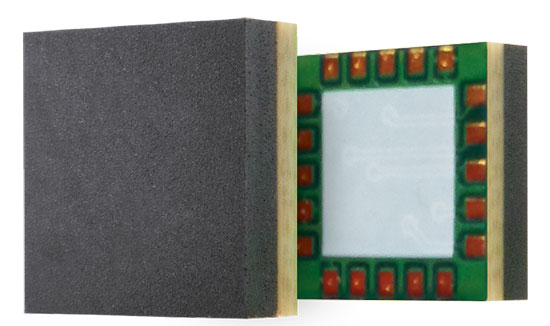
Telit’s Jupiter SE873 GNSS receiver with flash memory.
Telit has introduced the Jupiter SE873, a GNSS receiver in a 7 x 7 x 1.85 mm module with serial quad I/O flash memory, an integrated low noise amplifier, SAW filter, TXCO and real-time clock.
The new addition to Telit’s GNSS portfolio is a complete multi-constellation position, velocity and time engine that the company says delivers versatile performance in harsh environments.
The Jupiter SE873 supports Assisted GPS (both autonomous and server-based) plus Satellite Based Augmentation System (SBAS), which improve Time-To-First-Fix and position accuracy. AGPS data is stored in flash memory and is available even after all power has been removed and then restored. This is especially important for battery-operated equipment, Telit said.
The SE873 is a high-performance, high-sensitivity product that supports the entire GNSS spectrum: GPS, GLONASS and BeiDou, and it is Galileo ready. It delivers simultaneous low-power tracking of GPS and GLONASS or GPS and BeiDou. In the future, users will be able to add new functionalities.
“The SE873 outperforms all its competitors, most of which are ROM based. Employing flash memory results in a module that packs a lot of functionality into a small footprint,” said Felix Marchal, CPO of Telit.
Telit Jupiter SE873 is being presented to the market at Telit DevCon 2015 Sept. 8 and CTIA’s Super Mobility Week in Las Vegas Sept. 9. Telit DevCon is a one-day event that takes place the day before CTIA Super Mobility 2015 and is located close to the Sands Expo and Convention Center in Las Vegas. Visit Telit at booth #5032 during CTIA Super Mobility 2015.
Telit, a global enabler of the Internet of Things (IoT), today announced that Cellocator, a Pointer Telocation division, has selected the Telit IoT Platform as the underlying IoT Cloud infrastructure for its new CelloTrack Nano system. The platform, powered by deviceWISE, automatically performs all the critical connection, management and integration functions to simplify deployments of the Nano system across markets and industries worldwide.
The CelloTrack Nano system enables real-time status monitoring of goods in transit. That includes location and a variety of critical operational sensing of the cargo or asset in real time, using a portable hub and a short range Wireless Sensor Network (WSN). The sensors monitoring capabilities include temperature, humidity, light, pressure, impact, movement, tampering and sound. It ensures continuous recording, enables event-triggered logic and “management by exceptions” through flexible programming of business rules to eliminate supply chain mistakes, avoid delays or damages and reduce insurance expenses.
“We see high demand for the CelloTrack Nano in our traditional markets and count on Telit’s platform to bring us to the new IoT market,” said Joshua Rozanski, VP sales & marketing, Pointer Telocation. “By using the scalable, comprehensive Telit IoT Platform, Pointer has been able to concentrate on the rapid creation of a compelling, market-driven end-to-end solution.”
“Pointer has been a valued customer of Telit’s modules for almost a decade and we are pleased that they have now also selected the Telit IoT Platform as the go-to-market technology solution for their newly announcement Nano system,” said Gideon Rogovsky, SVP of Sales and Marketing, Telit IoT Platforms. “The deviceWISE Ready certification offers CelloTrack Nano instant exposure across our thriving deviceWISE ecosystem and opens instant opportunities with our global network of business partners and customers.”
The Telit IoT Platform connects “things” to “apps” — integrating any devices, production assets and remote sensors with web-based and mobile apps and enterprise systems. The platform reduces risk, time-to-market, complexity and cost of deploying solutions for monitoring and control, industrial automation, asset tracking and field service operations across all industries and market segments around the world. The Telit IoT Platform offers extensive developer resources and support and a free trial can be accessed here.
Anticipating New, Different Application and User Needs
Users in emerging applications may have different requirements from traditional high-precision users. New users increasingly look to the technology not solely for position, but to navigate them through the environment, often autonomously or semi-autonomously. Tracking all of the new multi-GNSS signals, and then using the large number of inputs in the positioning engine, drives the amount of processing power and memory required onboard the receiver. These in turn drive the cost, size and power consumption of the receiver in exactly the opposite direction from the expectations of customers.
By Jason Hamilton
In considering the future of high-precision satellite navigation, we need to consider what users of the technology are trying to accomplish, and which growing and emerging applications will drive adoption of GNSS technology in the future. These applications will drive growth in our industry if we can correctly anticipate their future needs.
Traditional applications of high-precision GNSS are well understood, but what these customers have demanded from GNSS can be at odds with what users in emerging applications require. Survey and mapping users were early adopters of high-precision GNSS and remain large user segments. Surveying with GNSS requires the very best accuracy that GNSS can achieve. Every centimetre of accuracy matters. Power and size are important product attributes to survey manufacturers. Mapping customers increasingly are asking for not just position, but orientation of a camera or other sensors.
Once accuracy challenges were well in hand, the topic of availability came into play. It was no longer good enough to have an accurate position in open-sky situations. Applications demanded continuous positions that were accurate in more and more corner cases and challenging environments.
In addition to using GNSS to measure location in an environment, new applications are increasingly looking to the technology to navigate them through the environment — often autonomously, or semi-autonomously. For these users, whether operating on a farm, in a mine, on the ground, or in the air, position accuracy is only part of the requirement. Solution accuracy of course matters, but other receiver attributes such as real-time quality control and solution integrity monitoring, are equally or more important.
Multi-constellation, multi-frequency GNSS provides tremendous opportunity and also presents significant challenges for receiver manufacturers. Constellation and frequency support has previously been a differentiator among high-precision GNSS providers, and among product generations. The relative stability of the satellite constellation definition means that the signals broadcast from space will be relatively predictable for some time into the future, and as such, GNSS products are increasingly supporting “all in view,” the ability to track everything that is broadcast.
The benefits of more satellites, more frequencies (and resulting frequency combinations) and modern signal structures have been well publicized. As new and modernized GNSS constellations come on line, they will deliver more robust positioning in increasingly challenging environments such as urban centers, open-pit mines and under tree cover. We will be able to account for atmospheric effects more accurately, which will help during times of high ionospheric activity and extend the length of RTK baselines. Users have a great deal to look forward to from their next-generation receivers.
All of these improvements necessitate pretty dramatic changes in receiver design. Tracking four global constellations and numerous regional SBAS systems increases the complexity of tracking and positioning firmware and algorithms. Tracking multiple frequencies and signal types on each of these constellations drives the receiver channel count up substantially. The days of the 12-channel receiver are gone. Channels, typically implemented within the manufacturers’ custom chips, drive application-specific integrated circuit (ASIC) complexity, which drives cost, power consumption and physical size. Some of this can be mitigated through the use of smaller process geometries, embedded processors and peripherals, and RF chip integration; however, there are down-stream effects to all of these signals as well.
Challenges
Once your receiver has enough ASIC channels to track all-in-view, you need to do something with all that data. The receiver’s tracking sub-system generates code (pseudorange), carrier-phase and Doppler measurements for every signal on each satellite. With four global and multiple regional constellations and up to four frequencies on each satellite, that amounts to a great deal of data. These measurements are what we turn into position, through a range of different positioning algorithms from code positioning to real-time kinematic (RTK) to precise point positioning (PPP). Tracking all of these signals, and then using the large number of inputs in the positioning engine, drives the amount of processing power and memory required onboard the receiver. These in turn drive the cost, size and power consumption of the receiver in exactly the opposite direction from the expectations of customers.
Bandwidth. Communications bandwidth is also a future challenge. Positioning methods, such as RTK, that transmit base-station observations for each GNSS signal to field rover receivers, will require much more bandwidth in the all-in-view future. PPP, which provides a state-space correction of the underlying GNSS error sources, is a promising alternative to RTK that scales better with more satellites than RTK and provides performance that is good enough for many applications.
Utilizing the multiple frequencies available from modern constellations also presents challenges to receiver designers. RF designers are faced with the opposing challenges of making GNSS receivers and antennas smaller, lighter and lower cost, while also supporting more GNSS broadcast frequencies and mitigating against increasing amounts of interference in the L-band RF spectrum from non-GNSS uses. Robust RF design makes the difference between a system that works most of the time, and a system that works reliably all of the time.
Expectations
If we now come back to the expectations of end users, the challenges are clear. Most customers actually don’t care about all-in-view tracking, how many satellites are tracked, or about what the receiver is up to behind the scenes. Users will judge their GNSS receiver on whether or not they are receiving a position that meets the requirements of their application. Are they meeting their targets for accuracy, availability, latency, data rate, and does the receiver fit from a size, power consumption, regulatory and cost perspective? After a certain level, more observations do not make the solution more accurate or more robust. Manufacturers need to carefully manage the tradeoffs in their systems on behalf of users to produce the best quality position possible, while still meeting the customer expectations on all the other receiver attributes.
Sensor Fusion. Demands of new applications drive GNSS providers to consider more than just position. Most vehicle control applications require orientation information as well as highly accurate position. Multiple-antenna GNSS heading systems are becoming smaller than ever. Inertial measurement device technology is also evolving quickly. Miniature micro-electro-mechanical systems (MEMS) inertial sensors can now deliver performance that only a few years ago was exclusive to large, heavy, bulky systems. The integration of GNSS and inertial technologies has been well adopted in highly demanding applications like aerial and ground mapping. As the size, weight and cost of the technology continues to shrink, sensor fusion in many forms will become the standard for all machine control and autonomous vehicle applications.
Safety. This is a key consideration for system designers working on remotely or optionally piloted and autonomous systems. Position and orientation accuracy is important, but so, too, is assuring that the solution is right and can be trusted. The accuracy of the solution needs to be characterized in real time so that control systems can react as necessary to protect users on and around the vehicle. Often in these applications, accuracy can be traded off against the robustness and reliability of the solution. This presents new ways of thinking for firmware and algorithm developers who have focused for so long on solution accuracy.
Support. Lastly, let’s not forget having reliable supply of high-quality product, and expert customer service to back it up. As high-precision GNSS attracts new users in a range of new industries, they are less often geodesists or geomatics engineers. The products absolutely need to be easy to use correctly, backed up by complete and accurate product documentation and supported by world-class application engineers.
Jason Hamilton is vice president of marketing at NovAtel Inc. Since joining the company, he has held a number of research, development and product management roles. Jason holds a Bachelor of Science degree in geomatics engineering from the University of Calgary and an MBA from Royal Roads University.
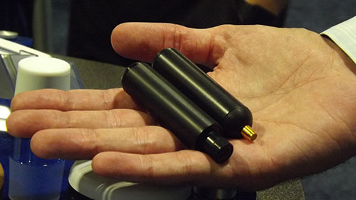
PCTEL’s GPS/GLONASS high-performance asset tracking and synchronization helix antennas are now available commercially. The antennas capture the frequencies needed for GPS, Galileo and GLONASS satellite reception. This cross-compatibility allows global OEMs to use one standard platform to serve both European and U.S. markets.
PCTEL will display its new IP67-rated GEO-GNSS antennas and other mobile and GPS antennas Sept. 16-17 at ION GNSS+, Booth #416.
PCTEL uses its proprietary filtering design to allow wideband coverage while achieving superior out-of-band rejection, the company said. The small form-factor helix antennas will withstand harsh environments.
“Customers expect PCTEL to solve challenging problems,” said Rishi Bharadwaj, PCTEL’s vice president and general manager, Connected Solutions. “We designed PCTEL’s GEO-GNSS series for complex asset tracking and network timing applications.”
For more information about PCTEL’s GEO-GNSS helix antennas, visit the PCTEL website.
Technology Advancement Group (TAG) will be showcasing precision, navigation and timing technology integration solutions at the ION GNSS+ conference, which will be held Sept. 14-15 in Tampa, Fla.
In particular, TAG will display a custom-designed military GNSS survey system that is the U.S. Army program of record for geodetic, construction and airfield surveying.
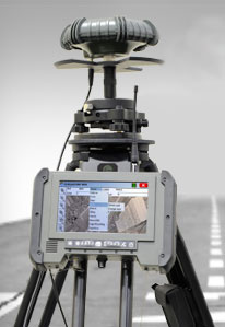
TAG’s Precise Positioning Service Global Positioning System Survey (PPS GPS-S) system was designed specifically for use by survey teams to have access to centimeter-level GPS survey accuracy with the added benefits of a fully-certified military GPS receiver that is supplemented with a GNSS receiver for real-time kinematic surveying with multi-constellation operations.
The PPS GPS-S system has been specifically designed to address the stringent requirements of military survey missions including geodetic, construction, airfield, and field artillery survey. It gives the military surveyor the tools they need to complete their missions with minimum time-on-station even in the face of GPS signal interference, attempted spoofing, or electronic warfare, the company said.
TAG was recently awarded a $24 million contract by the U.S. Army Geospatial Center for its AN/GSN-16 military survey system.
Core components of the PPS GPS-S system include a base station and two rovers, each integrated with a GNSS antenna with protection against jamming or spoofing, a custom-designed rugged tablet with an internal RF radio that has a 20-km range, and GPS-S accessories for additional functionality. Designed for continuous operation, the PPS GPS-S system includes multiple power options such as dual hot-swappable Li-Ion batteries, 12V battery, DC/DC converter, NATO adapter, and 4-slot Li-Ion charging station.
Powered by Carlson Surv-PC, TAG’s PPS GPS-S system is tailored for military environments that require tactical computer-aided design (CAD) operations. With an intuitive graphical user interface, surveying operations can be conducted in the field allowing for work to be completed in real-time. Accurate geospatial information system (GIS) data capture and a full suite of CAD functions allows survey teams to remain in the field to complete the drawings without the need to return to base.
For ION GNSS+, TAG will be in booth #102 of the exhibit hall in the Tampa Convention Center.
After extensive ground and space testing, the SES-5 GEO satellite has entered into the European Geostationary Navigation Overlay Service (EGNOS) operational platform, broadcasting EGNOS Signal-In-Space (SIS), according to the European GNSS Agency (GSA).
SES-5 — which replaces Inmarsat-4F2 — will ensure reliable EGNOS services until 2026. It has been introduced through EGNOS System Release V241M, which will enable a range of performance improvements. In particular, EGNOS will offer even greater stability during periods of high ionospheric activity.
“SES-5 is the first step of the complete renewal of the EGNOS Space Segment, securing the EGNOS services for the next decade and the future transition to the dual-frequency multi-constellation services,” said Carlo des Dorides, GSA Executive Director. “It will be completed by the introduction of the ASTRA-5B signals and the procurement of a new EGNOS payload which are both planned for 2016.”
SES-5, carrying EGNOS L1 and L5 band payloads, was launched in July 2012. The integration of a second EGNOS SBAS L1/L5 band payload on SES ASTRA-5B GEO satellite is currently ongoing. The introduction of this second SES GEO satellite for EGNOS is planned at the end of 2016. SES won the contract following an open-tender procedure.
“SES is looking forward to many years of successful operation in delivering EGNOS services to the European citizens and beyond,” said Ferdinand Kayser, chief commercial officer at SES.
EGNOS is operated by the European Satellite Services Provider (ESSP), under contract by the GSA on behalf of the European Commission.
Two of the Survey climbers continue their trek up towards the next base camp, with gear in tow. Much of the climbing was done at night or early morning to take advantage of the frozen ground. (Photo: Blaine Horner, CompassData)
A new, official height for Denali has been measured at 20,310 feet, just 10 feet less than the previous elevation of 20,320 feet which was established using 1950’s era technology.
With this slightly lower elevation, has the tallest mountain in North America shrunk? No, but advances in technology to better measure the elevation at the surface of the Earth have resulted in a more accurate summit height of Alaska’s natural treasure.
The mountain — known as Mt. McKinley since 1917 — was officially renamed Denali this week, a change announced by President Obama on the eve of his trip to Alaska. Denali is an Alaska Native name meaning “The High One” or “The Great One,” and is the name Alaskan have used for decades.
“No place draws more public attention to its exact elevation than the highest peak of a continent. Knowing the height of Denali is precisely 20,310 feet has important value to earth scientists, geographers, airplane pilots, mountaineers and the general public. It is inspiring to think we can measure this magnificent peak with such accuracy,” said Suzette Kimball, USGS acting director. “This is a feeling everyone can share, whether you happen to be an armchair explorer or an experienced mountain climber.”
Blaine Horner of CompassData probing the snow pack at the highest point in North America along with setting up Global Position System equipment for precise summit elevation data. (Photo: Blaine Horner, CompassData)
Denali National Park where the mountain is located, was established in 1917 and annually sees more than 500,000 visitors to the six million acres that now make up the park and preserve. About 1,200 mountaineers attempt to summit the mountain each year; typically about half are successful.
“Park rangers have been excited to work with and learn from their USGS colleagues using the latest technology to determine Denali’s height,” said Denali NP Superintendent Don Striker. “Climbers and other visitors will be fascinated by this process, and I hope our future park rangers see from this firsthand example how a background in science, technology, engineering and mathematics, and staying physically active in the outdoors can enable them to do some of America’s coolest jobs.”
To establish a more accurate summit height, the USGS partnered with NOAA’s National Geodetic Survey (NGS), Dewberry, CompassData, (a subcontractor to Dewberry) and the University of Alaska, Fairbanks, to conduct a precise GPS measurement of a specific point at the mountain’s peak.
A previous 2013 Denali survey was called into question with an elevation measurement of 20,237 feet. That survey was done by an airborne radar measurement collected using an Interferometric Synthetic Aperture Radar (ifsar) sensor. Ifsar is an extremely effective tool for collecting map data in challenging areas such as Alaska, but it does not provide precise spot or point elevations, especially in very steep terrain.
The climbing team of GPS experts and mountaineers reached the Denali summit in mid-June. Since then, they have been processing, analyzing, and evaluating the raw data to arrive at the final number of 20, 310 feet. Unique circumstances and variables such as the depth of the snowpack and establishing the appropriate surface that coincides with mean sea level had to be taken into account before the new apex elevation could be determined.
Survey equipment was powered on. The Zephyr-2 GPS was connected to the NetR9 with Teflon tape on the threads. One of the primary concerns was that the position equipment would not power on in the cold temperatures. Each had been wrapped in closed cell foam to provide insulation and neither had any problem turning on. (Photo: Blaine Horner, CompassData)
The Summit Survey
The summit team arrived at the top of North America’s highest peak around 3:15 p.m. on June 24. Their first task was to identify the true summit. A small diamond of snow was prominent near the south-face cliff edge and was identified as the highest point of the mountain. A range pole was driven into the snow near the true summit, leveled with the summit, and GPS equipment was installed and powered on.
The team of two returned to 14,000 feet following the summit survey. The equipment was left collecting until the following day when a team from Mountain Trip guiding service removed the receivers. Two days later the CompassData team returned to the summit and removed all remaining equipment.
The entire team safely descended the mountain and arrived at base camp at 7:00 a.m., June 29.
Processing the Data and Determining the New Elevation
To ensure the most accurate elevation number, specialists from CompassData, the University of Alaska Fairbanks and NOAA’s National Geodetic Survey all independently processed the survey data. Once they had preliminary results, a meeting was held to compare those calculations. All findings were consistent and remaining questions focused on how to express the new height. Ultimately, an agreement was reached in terms of the reference surface to be used and the rationale for using the North American Vertical Datum of 1988 (NAVD 88) as the vertical datum.
NAVD 88 is the official vertical datum for Alaska in the National Spatial Reference System (NSRS), a system that is defined and maintained by NGS to provide a consistent coordinate system across the entire United States. A new effort underway at NGS to modernize the NSRS by 2022 will incorporate an improved model of where the average sea level, or ‘zero’ elevation, is located; this will result in elevation values being more accurate with respect to mean sea level.
A USGS feature story has more details about the trek, data collection and calculation methods.
A view of Denali from the airplane as the Survey team approached the Kahiltna Glacier to begin their ascent to the mountain’s summit. Photo : Blaine Horner, CompassData)
On Aug. 24, David W. Madden joined Lockheed Martin’s Military Space Line of Business, where he will be responsible for international military satellite communications (MILSATCOM), based in Denver.
Madden served as the GPS Wing Commander at the Space & Missile Systems Center (SMC) in Los Angeles, Calif., before retiring from the U.S. Air Force in May 2010. From June 2010 until his new appointment, Madden served as director of the Military Satellite Communications Systems Directorate at SMC.
In his new role, Madden will oversee Lockheed Martin’s efforts to further enhance the company’s relationships with international allies and customers, and to grow the MILSATCOM portfolio.
At the Military Satellite Communications Systems Directorate at SMC, Madden was responsible for acquiring, deploying and sustaining the $42 billion MILSATCOM portfolio of programs which consists of ACAT I and II programs including the Defense Satellite Communications System, Milstar, Global Broadcast Service (GBS), the Wideband Global SATCOM, the Advanced EHF program, the Enhanced Polar System, the Command and Control System-Consolidated and associated Terminals programs.
Madden entered the Air Force in 1980 after graduating from the Virginia Military Institute. He gained experience in systems engineering, technical intelligence, and command and control and space systems requirements, development, fielding and operations. In addition, he has commanded a Space Operations Squadron and a Material Acquisition Group before the GPS Wing.
Telit, a global enabler of the Internet of Things (IoT), has announced a new release of the Telit IoT Portal. The portal consolidates a suite of advanced connectivity management functions with the company’s deviceWISE IoT Application Enablement Platform.
The service enables companies to deploy, configure and manage end-to-end IoT deployments from a single, cloud-based portal, Telit said. The portal is designed to make it easy to “connect thing to apps” by seamlessly integrating any device, production asset or remote sensor with web-based and mobile apps and enterprise systems, across any wireless network.
The newly added connectivity management addresses all aspects of mobile communication provisioning, including seamless integration with Mobile Network Operators (MNO) and Connected Device Platforms (CDP). Users can activate or de-activate devices, manage SIM cards, analyze connection quality, and set all provisioning and data plan parameters. This platform function is especially useful in preventing data overage and overall data cost management. The advanced CDP integration feature aggregates federated data across multiple wireless networks — a valuable capability when operating IoT deployments in different countries and regions around the world.
From the same portal, users have continuous access to all the comprehensive functions of the deviceWISE IoT Platform, including device onboarding, edge-intelligence, data collection, data transport, data storage, data delivery and application integration. Developers can connect, collect and control anything with a single, standardized API set that is common across device integration, connectivity management and application development.
“The developer-friendly Telit IoT Portal provides instant and full access to the mature and comprehensive features and all the necessary tools and resources for your IoT project,” said Alon Segal, CTO, Telit IoT Services. “No upfront investment is required and companies can focus on developing compelling applications that help transform their business, not the engineering of underlying technology infrastructure.”
The Telit IoT Portal reduces risk, time-to-market, complexity and cost of deploying solutions for monitoring and control, industrial automation, asset tracking and field service operations across all industries and market segments around the world. Additionally, customers can enjoy professional maintenance and support and ongoing upgrades to new features and capabilities. Access a free trial of the Telit IoT Portal.
The new release of the Telit IoT Portal will be featured at Telit DevCon, Sept. 8 in Las Vegas, and live demonstrations of will be held at CTIA Super Mobility 2015, booth #5032, which takes place Sept. 9-11 in Las Vegas. Those attending Telit DevCon can learn how industry leaders use the IoT to create new markets, transform their business and achieve measurable return on investment.
The 2015 State of the GNSS Industry Report reveals the results of our annual survey of GNSS professionals, covering the state of their business, the economic climate for GNSS products and services, driving market factors, the government’s role in funding and regulating, budgets devoted to R&D, the effects of jamming, and the “Issue of the Year.” Download the 2015 State of the GNSS Industry Report.