Tallysman, a manufacturer of economical high-performance GNSS antennas, has announced a new series of L1 band Accutenna wideband antennas for OEM applications. The antennas are offered in three formats for reception of GPS; GPS + GLONASS; or Galileo + GPS + GLONASS + BeiDou.
Each antenna type features Tallysman’s Accutenna technology, which provides high rejection of multi-path signals, with low axial ratios, and tight Phase Center Variations (PCV). Each is available with a brickwall pre-filter option to protect against saturation by high level sub-harmonic and L-Band signals.
Here are what each antenna in the new line covers:
The TW2106 is designed to receive GPS L1. TW2108 is the brick-wall pre-filtered version.
The TW2406 is designed to receive GPS + GLONASS. TW2408 is the brick-wall pre-filter version.
The TW2706 is designed to receive all of Galileo, BeiDou, GPS + GLONASS. TW2708 is the brick-wall pre-filter version.
The antenna PCBs are each 56 mm in diameter with four plated holes for secure mounting. They are available with a variety of connectors and custom cable lengths. The antennas can be custom tuned to ensure optimal performance within customers’ enclosures. All of them are REACH and ROHS compliant.
INTERGEO Announcement
At INTERGEO in Stuttgart, Tallysman will be announcing the availability of patented new GNSS antenna technology that it said is proving to:
Produce the lowest axial ratios from horizon to horizon through all azimuths and across all GNSS frequencies
Produce sub-millimetre Phase Centre Variation (PCV) through all elevations, all azimuths, and across all GNSS frequencies
Be lighter weight, smaller size, and more economical than other reference and geodetic antennas
Have the unique feature of having room within the antenna base to house customers’ circuitry.
Tallysman’s booth at INTERGEO will be in Hall E8, Booth 038. Follow GPS World on Twitter for the latest news from INTERGEO.
High-precision receiver maker JAVAD GNSS is expected to make a major announcement at this year’s INTERGEO conference, which takes place Sept. 15-17 in Stuttgart, Germany. JAVAD GNSS will showcase its technology in Hall 6 at Booth: G6.049.
At INTERGEO 2014, JAVAD GNSS introduced its unmanned aerial vehicle, the TRIUMPH-F1. The TRIUMPH-F1 is based on the TRIUMPH-1, JAVAD GNSS’s field-tested high-precision geodetic GNSS receiver with 864 channels to track all current and future GNSS signals.
This year’s new product developments from JAVAD GNSS are not known at this point, but the company has announced on its website the BEAST RTK, with 5-Hz Base Station Transmission. The BEAST RTK provides surveyors with faster fixes under tree canopy and the ability to collect five times as many epochs in a time period. “In my ‘bad spot’ under a tree, I am making it through 10 resets in less than 10 seconds,” said one user, John Evers, PLS.
In the video below, Javad Ashjaee, president and CEO of JAVAD GNSS, and GPS World Editor-in-Chief Alan Cameron discuss the design of the TRIUMPH-F1 at INTERGEO 2014.
With more than 16,000 visitors from 92 countries, INTERGEO — held each year in a different city in Germany — is the world’s leading conference trade fair for geodesy, geoinformation and land management.
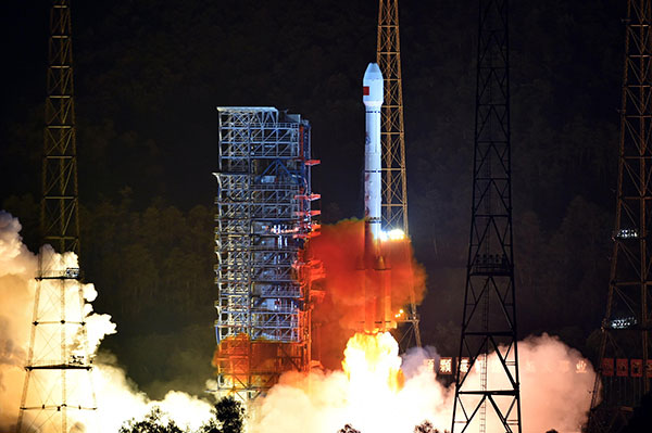
China launched two BeiDou navigation satellites into medium Earth orbit on July 25.
China launched two BeiDou navigation satellites into medium Earth orbit on July 25.
The two new satellites, BeiDou-3 M1 and BeiDou-3 M2, are in orbital slots 1 and 6 of Plane 1 (or A Plane), respectively. The satellites are designated BDS M1-S and M2-S — the “S” may stand for “Test” (in Chinese: 试验 = Shiyan).
On Aug. 14, China stated one satellite was working autonomously and had set up a link with the other satellite, successfully testing the autonomous control technology of the Beidou constellation. The inter-satellite link realizes communication and distance measurement among satellites, bringing autonomous control of the system a step closer.
Autonomous navigation is the project’s key to global operation. It enables satellites to work independently, providing users with more accurate data, according to BeiDou design engineers.
On Aug. 9, signals from the two new BeidDou satellites were received with a software-defined radio sampler operated at the European Commission’s Joint Research Centre in Ispra, Italy. The sampler is driven by orbit-prediction software that triggers a synchronized acquisition on both 1575.42 MHz and 1278.75 MHz using 1-bit complex samples at 60 megasamples per second (about 60 MHz total bandwidth). The two-line element sets for the orbits were obtained from the CelesTrak website, and predicted positions were computed using code developed following the Simplified General Perturbations Satellite Orbit Model 4 (SGP4) as documented in the U.S. Department of Defense Spacetrack Report No. 3.
To confirm the identity of the satellite being tracked using codeless tracking, we matched the measured Doppler frequency shift with the predicted one. The local oscillator clock drift was modeled using GPS L1 C/A-code signals and taken into account when matching the Doppler shift.
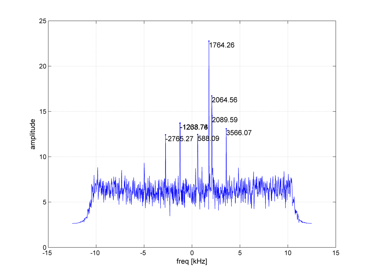
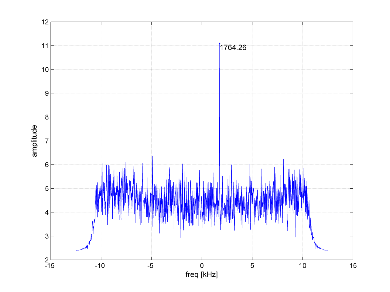
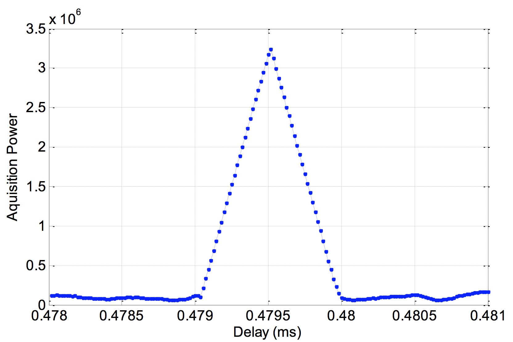
According to a presentation given at Stanford University’s 2014 PNT Symposium by Mingquan Lu and Zheng Yao from Tsinghua University, modernized BeiDou satellites broadcast an MBOC(6,1,1/11) [a multiplexing of BOC(6,1) and BOC(1,1) signals] and a BOC(14,2) signal on the L1 frequency. Neglecting the BOC(6,1) term, side lobes were brought to baseband and cross-correlated by our equipment. In Figure 1, the peak at 1756.41 MHz is BEIDOU-3 M2. This is also confirmed by cross-correlating the lobes of the BOC(14,2) signal, which is quite a unique feature of the new satellites (see Figure 2).
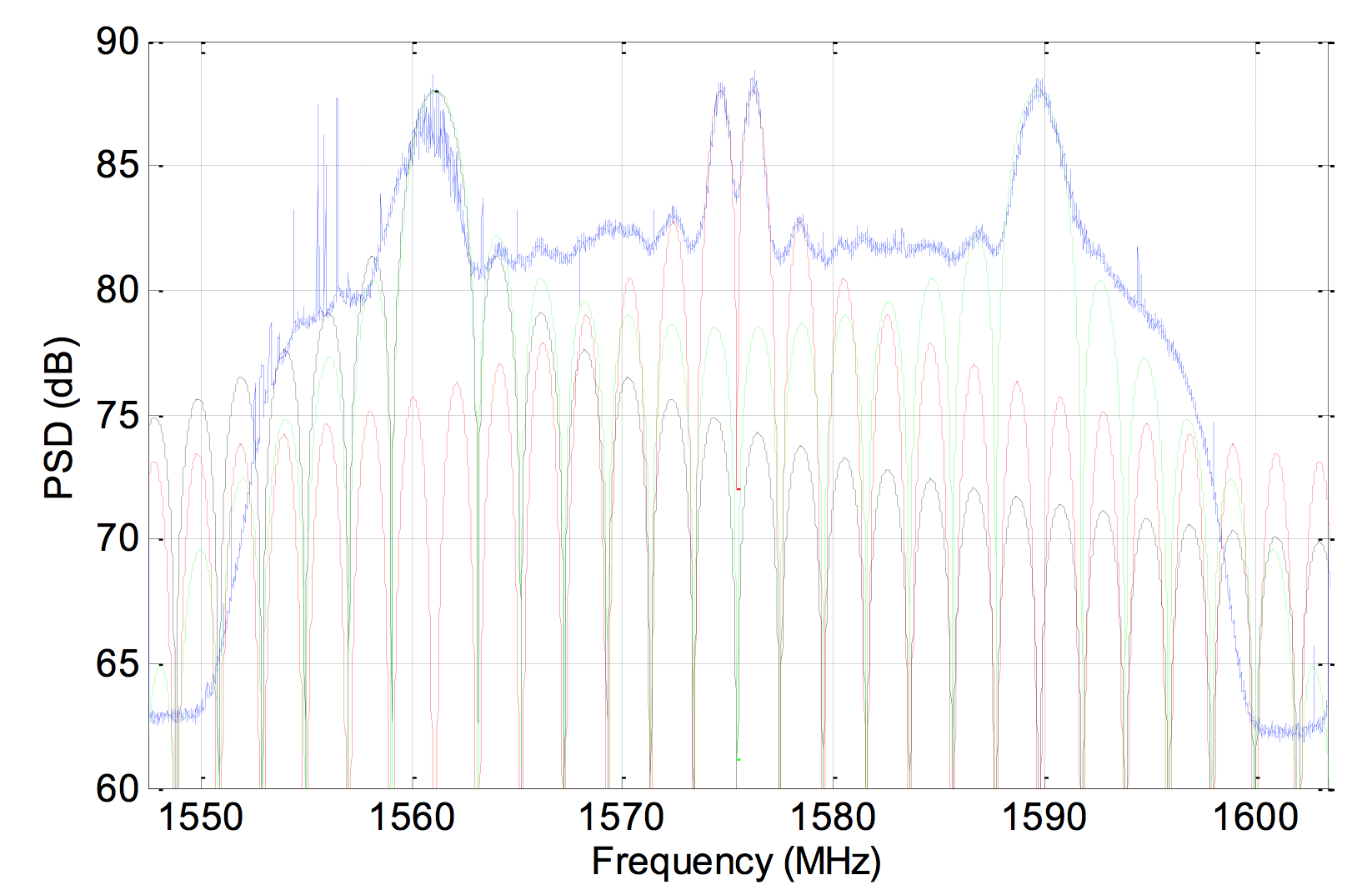
On Aug. 10, a 1.8-meter dish was pointed at the satellite, and a Tektronix RSA306 USB Real Time Spectrum Analyzer was used to sample the signal on L1 with 14-bit resolution at 112 megasamples per second. The resulting power spectrum is shown in Figure 3.
Figure 3. Power spectral density of BEIDOU-3 M2 on L1.
The spectrum shows very good overlap between the anticipated BOC(1,1) signal in red, BOC(14,2) in green and BPSK(2) in black. In fact, PRN33 correlates with the low side lobe suggesting that the satellite is also broadcasting a legacy signal on 1561.098 MHz (see Figure 4).
Figure 4. Cross-correlation of a BPSK(2) BeiDou code PRN33 on a 1561.098-MHz carrier.
Meanwhile, tracking by stations participating in the International GNSS Service Multi-GNSS Experiment has established that the second recently launched BeiDou Phase 3 MEO satellite is using PRN code 34, and that the first Phase 3 satellite, BeiDou I1-S launched on March 30, 2015, into an inclined geosynchronous orbit, is using PRN code 31.
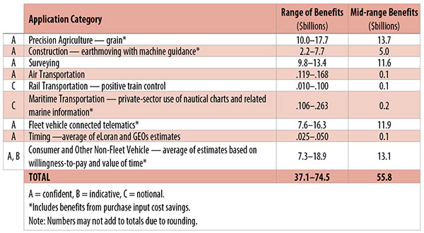
Table 1. Preliminary 2013 U.S. GPS economic benefit estimates. (Chart: GPS World, based on data from author)
This article is based on a presentation to the National Space-Based Positioning, Navigation and Timing Advisory Board in June 2015. The study reported on at the meeting was requested by the National Executive Committee for Space-Based Positioning, Navigation and Timing. It demonstrates the widespread use and importance of GPS to the U.S., with estimated benefits in 2013 of about $56 billion, or 0.3% of GDP for a subset of applications. The study is the first part of an effort that is expected to refine and extend this analysis.
By Irv Leveson
Critical to many civilian applications and innovations, GPS brings great economic benefits. These benefits have grown rapidly with the integration of GPS with other technologies and its wider and deeper infusion into applications. New GPS signals and other improvements in the system will further expand and enhance use. The unmistakable conclusion: GPS is everywhere.
Benefits of GPS to the U.S. will increase with the availability of other GNSS systems, even though GPS will constitute a smaller share of global GNSS benefits. The U.S. will continue to provide leadership, standards and innovation in technology and applications with positive domestic feedback.
GPS and other GNSS and enhancements raise productivity; reduce and avoid costs; save time; enable improved and new production processes, products and markets; increase health and well-being; reduce injury and loss of life; improve the environment; and increase security.
The National Executive Committee for Space-Based Positioning, Navigation and Timing (PNT), which is responsible for maintaining U.S. leadership in GNSS, commissioned a study to assign a quantitative value to the broad economic uses of GPS. The purpose is to inform the public, federal decision makers and critical infrastructure owners/operators on the importance of GPS and the need to protect it from disruption. Assessing the economic implications of actions such as preventing or disallowing interference, spectrum reallocation, developing supplementary or backup systems and/or toughening receivers can be informed by value estimates and the data used to derive them. In addition, economic values can contribute to planning for GPS modernization and analysis of budgets. Baseline estimates facilitate comparisons with future developments. GPS benefit estimates will be “ballpark” no matter how sophisticated the methodology because of limits to the availability of information, but in many cases, knowing orders of magnitude is essential in choosing courses of action.
Widespread, Pervasive Impact. The technological environment is one of rapid changes in information and materials technology and integration of technologies at levels ranging from systems on a chip to large-scale systems. GPS is increasingly integrated with other technologies and systems that build on each other to achieve greater outcomes.
The U.S. Department of Homeland Security counts GPS as an enabling technology because of its crucial role in 14 of the 16 industries that are classified as part of the nation’s critical infrastructure. It is useful to view GPS’ role as being especially important in “enabling the enablers,” industries that particularly support the rest of the economy and are at the forefront of economic growth. The most notable of these are transportation, communications, power and financial services.
Economic Value versus Impact
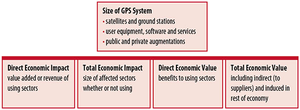
Economic value is the addition to the value of the economy from the provision of a good or service, or the introduction of a technology. Benefits are measured relative to what would have been expected if there were no GPS. Direct economic value is the increase in value in using sectors. Total economic value includes increases in value to suppliers and value induced in the rest of the economy.
Direct economic impact, on the other hand, refers to measures of the importance of sectors that are using GPS. Total economic impact is the importance of sectors affected by GPS, whether they are using it or not. Total economic impact of GPS is virtually the size of the whole economy, so it is not very meaningful.
Direct economic impact is measured by value added of using sectors when the purpose is to avoid duplication among sectors that buy from and sell to each other. It may be measured by revenue for a single sector when adding sectors is not involved, so there is no need to avoid duplication.
The distinction between economic value and economic impact is critical. Even if economic impact is measured by value added rather than revenue, the value is not the net addition to the economy from the use of the product or technology. It is only the size of the using sector. See Figure 1.
Figure 1. Measuring GPS economic value and economic impact. (Chart: author)
The GSA Study
The most comprehensive estimates of global GNSS market size come from the European GNSS Agency (GSA), which has released four market reports from 2010 through 2015. The data are measures of economic impact and not economic value. The reports are of great interest because of their comprehensive global look at the sizes of markets and inclusion of forecasts. In contrast, the emphasis in this part of the present study is on current economic value, with U.S. benefits assessed for GPS.
One reason for interest in the GSA reports is that market information and projections often are proprietary and there can be great inconsistency across market research studies. GSA makes use of many confidential studies without revealing which sources contributed to each estimate. It apparently has been allowed to incorporate proprietary information from a number of market research firms since the data is subsumed in GSA’s own estimates and/or presented in graphs for which underlying numbers are not provided — and from which it is often difficult to even roughly extract them.
The 2015 report stated the methodology as: “The underlying forecasting model uses advanced forecasting techniques applied to a wide range of input data, assumptions and scenarios…Where possible, historical values are anchored to actual data.” Results were checked against opinions of market segment experts and market research reports. However, these analyses are not provided in the reports and have not been made available.
A distinction is made between the core market which covers the value of components that provide GNSS functionality in devices and enabled markets which “represent the services and devices enabled by GNSS.” The 2015 report provides global data on both core and enabled market and goes into much more detail on core markets for application sectors. In addition to providing sector information that did not appear previously, the 2015 report presents data on the extent to which each combination of the GNSS constellations was supported by receivers or chipsets offered by suppliers. Additional information on enabled sectors is in earlier reports.
GSA found in its 2015 market report that:
3.6 billion GNSS devices were in use globally in 2014, of which 3.08 billion were smartphones and .26 billion were for road.
North America had about 450 million devices installed (about 80% U.S.).
North America had 1.4 devices per capita in 2014.
North American shipments were 250–300 million in 2013.
Global core revenue was estimated at roughly €62 billion and enabled revenue at €227 billion in 2014. As noted, core revenue includes GNSS device components, software and services, while enabled revenue refers to applications.
Location-based services (LBS) was projected to account for 53.2% of 2013–2023 core revenue growth, and road for 38%.
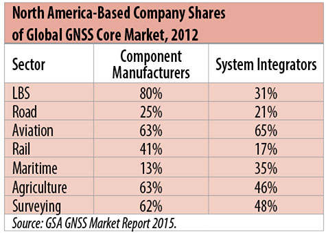
North American-based companies had sizeable shares of the global GNSS core market in 2012, particularly among component manufacturers. (See Table 2). Their market share among system integrators was highest in aviation.
North American-based companies had a 44% market share of value-added services revenue in 2012.
Table 2. North America-based company shares of Global GNSS core market, 2012. (Chart: author)
Markets and Applications
The pervasiveness of GPS-enabled applications is illustrated by the following statistics:
900 million mobile phones that incorporated GPS were sold globally in 2012.
The U.S. had 188 million smartphone subscribers and 263 million Internet users in 2013.
20% of U.S. mobile phone users get up-to-the-minute traffic or transit information.
The new industry category in the 2012 North American Industrial Classification System: “Internet publishing and broadcasting and web search portals” had U.S. revenue of $87 billion and 181,000 employees in 2012.
Google estimated that its search and advertising tools provided $111 billion in economic activity in the U.S. in 2013.
Deloitte estimated that Facebook enabled $104 billion of economic impact and 1.2 million jobs in North America in 2014.
Google Play and the Apple App Store each had more than 1.2 million apps in 2014.
How GPS Is Used. Uses of GPS include:
In agriculture for auto-steering tractors, combines and sprayers for precise operation, variable rate technology for precise placement of seed, fertilizer and pesticides, and for yield monitoring.
Managing forest health and ecological restoration, reducing fire and other hazards, and harvesting forest products.
In commercial fishing, navigation, finding fishing locations and monitoring fish catch by authorities.
In construction to direct the movement of dozers, excavators, pavers, scrapers, compactors and other heavy equipment and the placement of blades to give precise results.
In open-pit mining to guide loaders, dozers, drills and draglines.
In offshore energy exploration and development, for drilling, installations, pipe laying, diving operations, pipe inspection, repair and abandonment.
In surveying, to greatly reduce costs and to improve quality of products that rely on it.
In aviation, for navigation and monitoring positions of aircraft and for satellite-based augmentation systems (WAAS in the U.S.). GPS is the principal source for navigation for aircraft equipped with Area Navigation (RNAV) or Required Navigation Performance (RNP).
Railroad train pacing systems for cruise control, positive train control to keep track of train location and movement authorities, track defect location, and locating trucks with rail workers.
In marine transportation, for navigation, collision avoidance, communications and situational awareness and for monitoring by offshore authorities.
In vehicles, with handheld and embedded devices for navigation and fleet management.
For precise timing and time synchronization and frequency coordination (syntonization). It is used most notably in broadcasting and communications, including both cell phones and traditional telephone applications and the Internet, so packets arrive at the same time, for power generation and distribution to locate problems, and in financial services for time-stamping transactions.
In first responder services for location, navigation and communications and in emergency warnings and evacuations.
In structural monitoring of dams and bridges.
In environmental monitoring, including vegetation growth and sea-level change.
LBS and GIS
Rapid growth is taking place in location-based services (LBS) and geographic information services (GIS), which include everything from indoor location to many aspects of the Internet of Things and the “sharing economy,” and sophisticated systems for information management, analysis and display.
GPS is used for tracking and inventorying assets ranging from heavy machinery on farms and construction and mining sites, to pipes and other materials, containers in trucking sites and ports, and the location of utilities in the ground. In logistics it facilitates planning of product flow and transport.
The growth of same-day delivery — which takes advantage of Internet, cell phone, and location and navigation technologies enabled by GPS — is a continuation of the growth in just-in-time delivery that has been a phenomenon in manufacturing for several decades. Now it is having a profound effect on wholesale trade, retail trade and transportation.
The size of the LBS and GIS sectors is not defined and measured in a consistent way, and except for vehicle use, there is little information on productivity and saving in costs and time. (See sidebar box.)
LBS and GIS Market Size Estimates
For LBS and GIS, definitions and measures can vary greatly and often are not explicit.
Location-Based Services Market Size Estimates
Frost & Sullivan estimated the global LBS market at €22.8 billion in 2012 and forecast €32.0 billion in 2015.
Market and Markets estimated global LBS revenue at $8.1 billion in 2014.
Berg Insight estimated North American LBS revenue at $835 million in 2012.
(The U.S. can be assumed to spend 20–25% of the world value and about 80% of the North American value.)
Geographic information Systems Market Size Estimates
BCG estimated revenue of the U.S. GIS industry at $73 billion in 2011.
The global GIS market will reach $10.6 billion in 2015, according to a report of Global Industry Analysts in 2013.
The Canadian Geomatics study found private-sector spending of $2.3 billion in 2013. If U.S private spending was the same percentage of GDP, it would be $23.6 billion.
International Trade
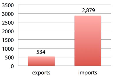
Official data show a $2.3 billion U.S. deficit in trade in GPS equipment in 2013. This gives an incomplete and misleading picture of the role of the U.S. and the benefits that result. See Figure 2.
Figure 2. U.S. trade in GPS equipment, 2013 (millions of dollars). (Chart: author)
The trade numbers for GPS equipment do not include revenue for licensing, international payments received by social media and e-commerce companies, or other Internet-based revenue for which the U.S. may have a substantial net trade surplus and which are an important source of revenue and profits of U.S.-based companies.
Imports of GPS equipment software and services enable the U.S. to gain more efficient production in many applications at home and enable the U.S. to export more goods and service that rely on GPS.
Exports of GPS equipment come back to the U.S. as components that benefit U.S. businesses and consumers with more capable products and lower prices. Exports of GPS equipment enable other countries to build on the technologies and contribute to innovation, while imports enable the U.S. to share in foreign innovations. Exports of GPS equipment and associated knowledge also raise incomes in other countries, creating larger markets for U.S. goods and services.
Scope of Benefit Estimates
The U.S. benefit estimates reported here are the result of an initial effort and are not meant to be comprehensive. More work is expected to be done to fill in some of the gaps.
Sectors were chosen based on availability of information to permit relatively robust estimates and importance to the economy or policy issues. These considerations limited the number of sectors for which estimates could be made. Methods were determined based on the nature of available studies and varied among sectors. Only economic benefits were included, with health and safety and environmental benefits left for later research.
Benefits include the value to users above their costs (consumer surplus). Benefits of GPS are compared with alternatives without GPS or an application using it (counterfactuals). Estimates are gross. They are not reduced by the costs of achieving the benefits. Contributions of augmentations are included, since a quantitative basis for separating them is not available.
Estimates were primarily benefits through productivity and cost savings in operations, with savings in input costs included where their magnitudes were clear. Benefits to the rest of the economy are not included. Illustrative allowances were made for the contributions of other technologies and systems to the outcomes examined.
In the case of GPS timing, the estimates were based on the costs avoided by not having to develop an alternative timing source on the assumption that the type of alternative source possible would have evolved from the time GPS became available. The measure does not represent the value of GPS time and synchronization to the nation and to users relative to the absence of a precise time and frequency source.
Government was included in the estimates for construction, surveying, and fleet and non-fleet vehicles. For timing and non-fleet vehicle benefits, two alternative measures are averaged. Sectors with lower quality estimates — rail and maritime transportation — were included because of their importance to the economy. Shares of benefits attributable to GPS were rough assumptions. More robust estimates would require extensive data collection and interviewing in studies greatly exceeding available time and resources.
The primary focus was on productivity improvements, cost savings and cost avoidance, where costs include users’ time. Productivity increases and cost reductions allow more to be produced with the same amount of resources in the sectors utilizing the technology or allow resources to be freed up for other purposes. In that sense, they are equivalent.
When benefits are measured by productivity gains or cost savings, much of consumer surplus (the value to users above what they pay) is implicitly included. Some sources measure value by willingness-to-pay. Willingness-to-pay includes consumer surplus. It also encompasses costs of the purchase and other costs incurred by the user.
Criteria for Selecting Sectors
The potential for making sector estimates of economic benefits was categorized in three basic levels:
confident: based on robust estimates.
indicative: based on one or more less robust estimates.
notional: illustrative, if major contributions of other technologies are not separated and estimates must be based on a plausible percentage of a larger benefit, or if information is not available and estimates must be based on a percentage of market size.
Choices among categories for estimation and estimation methods depended not only on which of the basic criteria are satisfied but also on the following additional criteria:
The importance of the sector to the economy, for example as an enabler of other activities.
The potential use of benefit estimates for the category as an input into analyses of the effects of signal disruption.
Several dozen studies were assessed to determine categories for inclusion and to select studies that can form the basis of estimation. Studies for use in estimation of benefits in a category were chosen according to how well they met the following criteria:
GPS. A test of introduction of GPS or comparison with and without GPS rather than benefits of a broader service.
Coverage. Estimates that cover a major part of the category.
Robustness of estimates, including the type of review the source is likely to have had.
Consistency. If alternative better estimates are not in such a wide range that an average is less meaningful except where explainable by expected sources of variation.
Timeliness. Preference to a recent period being covered by the estimates.
U.S. Economic Benefit Estimates
Preliminary estimates of economic benefits for included U.S. sectors totaled $55.8 billion in 2013. Averaging the alternative estimates, the sum of the benefits in the two vehicle categories is $25 billion, by far the largest of the sectors estimated. Next were agriculture with $13.7 billion, and surveying with $11.6 billion.
Economic benefits are underestimated for several reasons. Some sectors are not included because of lack of information on productivity and cost savings, namely LBS other than vehicle, including asset tracking and locating people; GIS and mapping other than nautical charts, forestry, fisheries, mining, energy exploration and development, land and coastal management, weather, and scientific applications and space.
Parts of others are not included: non-grain agriculture, construction other than earthmoving, GPS in aviation for some Area Navigation (RNAV) Standard Instrument Departure Routes (SIDs) and Standard Arrival Routes STARS) and Required Navigation Performance (RNP), and rail other than positive train control.
Some estimates are conservative. The value of saved time in non-fleet vehicle transportation is based on the recommendation of the Transportation Research Board rather than the much higher value used by the U.S. Department of Transportation.
Some types of benefits are not included — specifically, benefits of GPS timing applications above the cost of alternatives, and avoided income loss, property damage and medical costs associated with reduced accidents and improved emergency response.
Increases in benefits between 2003 and 2005 are not estimated.
And, as indicated, non-economic benefits such as those to health, safety, security, reduced loss of life and to the environment are not yet addressed.
Benefits as measured thus far are about 0.3% of GDP in one year. If all of the excluded sources of benefits were quantified, the benefits would be much larger.
Estimating Benefits for Sectors
U.S. economic benefits of GPS for grain farming were estimated for farms with grain sales of $250 million or more. The same method as was applied for earthmoving in construction.
A composite range of percentages of productivity gains and cost savings of 18–25% was determined from various studies. In the case of grain farming, benefits also come from yield increases due to improvements in plant health. The productivity gains used in the calculations incorporated both sources of benefits. Productivity was taken together with market size and an estimate of 68% adoption of technologies taking advantage of GPS to compute initial estimates of benefits. A notional adjustment was then made to exclude the contributions of other technologies and GNSSs. While having the adjustment determined by a group of experts would have been preferred, that was not possible with the time and resource constraints of the study.
Benefits of GPS machine guidance with earthmoving in construction were calculated based on an 8–12% share of construction for earthmoving operations, a benefit of 18–22% and a 20–25% adoption rate, relying on a number of sources.
For surveying, an estimate of market size was constructed based on U.S. Bureau of Labor Statistics data on numbers of surveyors, cartographers and photogrammetrists in the engineering services industry vs. the rest of the economy, together with revenue data for private surveying and mapping from the Economic Census. This was combined with a composite estimate of productivity gains over conventional surveying of 45–55% and an assumption of 100% adoption.
The benefit values for air transportation were estimated for the study by the Federal Aviation Administration (FAA) based on effects of WAAS and performance-based navigation (PBN). The rail estimates cover only positive train control, which is in early stages of implementation. Information is highly uncertain, but impacts as of 2013 are small. Maritime benefits were based on updating an earlier estimate of benefits of the private-sector value of nautical charts. The estimates for fleet vehicle-connected telematics were based on savings found in an extensive survey of fleet customers over a five-year period.
Timing benefits were based on the avoided costs from not having to develop an alternative source of timing. Alternatives considered were eLoran and a system of three geostationary satellites. Since there would have been strong pressures to develop an authoritative timing source in the absence of GPS timing, it was assumed that one of the alternatives would have been developed rather than assuming as in other cases that technologies in use when GPS became available would have continued in use.
Two estimates also were made for consumer and other non-fleet vehicle use. One was based on extrapolating results of a study of consumer willingness to pay for navigation services, and the other on time saved by navigation services.
Part of the benefits of LBS other than those that are vehicle-related and for GIS are implicitly included in estimates for sectors that use them.
Data and Research Needs
Additional work would be desirable to extend and refine the GPS economic benefit estimates, quantify safety-of-life and environmental benefits, examine international benefits, assess potential future benefits and consider loss from denial of GPS. Benefits of many new and rapidly growing services are yet to be quantified.
Systematic research is needed to fill in gaps in adoption, productivity and cost savings with comparative before-and-after studies as well as with case studies. Robust studies require major and often multi-year efforts involving targeted data collection, which are rarely done by government or academics for GNSS. Information needs to be much more granular, taking into account specific functions in which GNSS is used (such as plowing, seeding, fertilizing, harvesting), specific GNSS and non-GNSS technologies employed in each function at each site, and extent of their use.
Also, results for GPS might be improved or at least be more acceptable if the contribution of other technologies and GNSSs to measured benefits were assessed by a group of knowledgeable individuals rather than by a single researcher.
Information on market size, penetration and growth from market research firms, which tends to capture recent developments, is based on greatly varying sources and methods, resulting in major gaps and great divergence in estimates, especially in new or rapidly growing areas like LBS and GIS. The North American Industrial Classification System (NAICS) and its application in federal data collection such as in the Economic Census lags far behind in recognizing new categories and providing sufficient detail. Lags in data collection and research lead to understatement of the use and benefits of GPS.
Looking to the Future
Future benefits are expected to be even greater because of evolution of technologies, expansion of GNSS systems, creation of new products and markets, and growth and penetration of markets. The possibilities are suggested by the numerous nascent applications that have been emerging. Many will be enabled by expanding GNSS systems, signals and capabilities in conjunction with geographic expansion and increased capabilities in wireless systems.
The progression of platforms is long and growing: mainframes, PCs, mobile phones and other handheld devices, tablets, game controllers, wearables, TVs, home appliances, air and space — including planes, UAVs, satellites, planets, moons, rovers, rockets and spaceships.
The widespread availability of platforms and the growing ability to utilize them promises a long way to go in developing applications and deriving benefits.
Acknowledgments
The author thanks the PNT Advisory Board and Gov. Jim Geringer, liaison from the board to the study; Jason Kim of the Department of Commerce who oversaw the project; Jim Miller of NASA; and the members of the interagency Economic Study Team that advised the effort. Numerous additional people in and out of government provided information and assistance. Responsibility for the content and findings rests with the author.
IRV LEVESON, who has a Ph.D. in economics from Columbia University, is an economic and strategy consultant and founder of Leveson Consulting. He has done extensive work on GNSS markets and issues for more than 10 years. He is a member of the Institute of Navigation, the American Economic Association and the National Association for Business Economics.
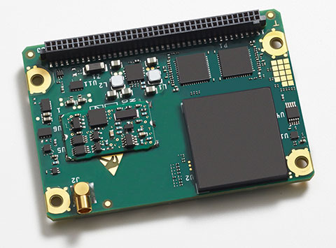
The Rockwell Collins GB-GRAM-M (pictured here) is the product of one of the MUE card development contracts, awarded by the U.S. Air Force Space and Missile Systems Center. The program is developing the next generation of GPS user equipment to include a new military signal and enhanced security architecture
GPS Source and Rockwell Collins have successfully demonstrated the ability of the Military-Code Ground-Based GPS Receiver Application Module (GB-GRAM-M) receiver card to fit within the Defense Advanced GPS Receiver (DAGR) Distributed Device (D3).
GPS Source and Rockwell Collins are the first to provide this capability for the M-code signal, which is one of the key elements in the modernization of military GPS capabilities.
The initial fit checks confirm that the Rockwell Collins GB-GRAM-M Type II receiver fits within the volume of the D3 and is able to acquire, track and navigate using C/A, Y and M-code while enclosed in the unit. Initial testing also validated backwards compatibility of the IS-GPS-153 serial port interface of the GB-GRAM-M receiver.
“These outstanding initial results confirm our confidence that the MGUE integration with the D3, when authorized to proceed, will be achieved in short order and with a very high probability of success,” said GPS Source CEO Robert Horton.
Mike Jones, vice president and general manager of Communication and Navigation Products for Rockwell Collins, added, “This demonstration paves the way for the D3 to incorporate the next-generation GPS capability that our GB-GRAM-M provides.”
GPS Source’s D3 supports new or retrofit programs integrating radio or communications equipment. It removes the burden of multiple SAASM GPS receivers or antennas. As a Selective Availability Anti-Spoofing Module GPS router, it is designed to meet the U.S. Army’s DAGR Distributed Device (D3) performance requirements, mounted into an existing DAGR vehicle mount, utilizing standard DAGR accessories.
The Rockwell Collins GB-GRAM-M is the product of one of the MUE card development contracts, awarded by the U.S. Air Force Space and Missile Systems Center. The program is developing the next generation of GPS user equipment to include a new military signal and enhanced security architecture.
GlobalTop Technology has launched FireFly X1, a tiny Mediatek-based multi-GNSS module. With a compact size of 9.0 x 9.5 x 2.1 millimeters, it’s one of the smallest multi-GNSS modules in the industry, the company said.
“Compact size and low-power consumption will be the key [unique selling points] for the next generation of M2M Devices,” said Sam Khan, vice CEO of GlobalTop Technology. “After a comprehensive market study, we found that small size was one of the most important factors for companies when it came to GNSS module selection; other key factors included power consumption, TTFF, positioning accuracy, additional interfaces as well as quality and longevity of the module. I am proud to say that FireFly X1 delivers perfectly on all these criteria.”
According to Khan, the FireFly X1 was designed with “sophisticated engineering and an entirely new set of ultra-compact quality components to reach this miniature size, while adding more features and interfaces at the same time.” It uses the latest MT3333 engine with full support for GPS, QZSS, GLONASS and BeiDou, and is Galileo ready.
Tracking of up to two constellations simultaneously, and relying on the latest Mediatek firmware, it can provide positioning accuracy of up to 1.8 m CEP. Enabling EASY (self-generated orbit prediction), AGPS (ephermis file injection) and SBAS further enhances position accuracy.
Despite a smaller size, FireFly X1 incorporates a complete set of high-quality components, including TCXO, RTC Crystal, SMPS, SAW Filter and an additional LNA to provide reliable performance.
FireFly X1 combines miniature size with flexible multi-interface connectivity options such as SPI and I²C that can simplify a user’s design, and is designed for M2M devices relying on low-cost MCUs that offer limited serial interfaces.
GlobalTop’s free customization service further expands the capability of FireFly X1 with features such as custom NMEA output sentence, distance calculation, geofencing, magnetic variation and last- position-retention. Advanced users can also customize the basic parameters of the module, including baud rate, update rate, internal logger settings, DGPS mode, 3D Fix, 1 PPS timing, and more.
All modules are produced at GlobalTop’s in-house ISO 9001:2008 certified manufacturing facility, with 100 percent unit testing and complete quality control, allowing for a consistent annual yield rate of 99.98 percent.
Samples and Evaluation Kits for FireFly X1 are now available. Please contact us or your local distributor for more information.
Sony is developing an unmanned aerial vehicle that lifts off and lands vertically like a helicopter (also known as a VTOL craft for vertical take-off and landing.) The VTOL drone is being developed with a Tokyo robotics firm under a collaborative company called Aerosense.
The drone can carry up to 22 pounds, fly continuously for two hours, and reach a speed of 106 miles per hour. Sony is developing it for business customers, who would use it for “measuring, surveying, observing and inspecting” as soon as next year, so it will likely carry different types of instruments, depending on the task a customer requires.
The video below shows a prototype flight on Monday.
Aerosense, created this month, is a joint venture between Sony and Tokyo-based startup ZMP Inc., which specializes in autopilot technology. The venture is part of Sony’s efforts to move beyond its core consumer products into enterprise markets. Aerosense will offer services such as inspecting aging infrastructure and surveying land that is difficult to access. The drones would be piloted automatically based on input from users about which areas they want surveyed.
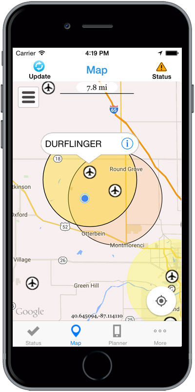
The Federal Aviation Administration (FAA) has released the beta version of a new smartphone application called B4UFLY for testing by up to 1,000 unmanned aircraft users.
The B4UFLY app, aimed primarily at model aircraft enthusiasts, is designed to give users information about restrictions or requirements in effect at their current or planned flight location. The FAA expects the beta test will yield valuable data on how well B4UFLY functions, as well as uncovering any software bugs.
FAA Administrator Michael Huerta first announced the initiative in May, asking for volunteers to test the app. The FAA has notified those who previously signed up and will be pushing the app to them directly in the coming days.
Many unmanned aircraft users today have little or no aviation experience, and some of them are flying where they could endanger manned aircraft. B4UFLY will give these flyers the tools and knowledge they need to operate safely.
Key features of the B4UFLY app include:
A clear “status” indicator that immediately informs operators about their current or planned location.
Information on the parameters that drive the status indicator.
A “Planner Mode” for future flights in different locations.
Informative, interactive maps with filtering options.
Links to other FAA UAS resources and regulatory information.
B4UFLY complements the Know Before You Fly educational campaign, which provides prospective UAS operators with information and guidance they need to fly safely and responsibly. The FAA is a partner in the effort with the Association for Unmanned Vehicle Systems International (AUVSI), Academy of Model Aeronautics (AMA), and the Small UAV Coalition.
Using the location services feature of a user’s smartphone, the app quickly determines restrictions or requirements in effect where they want to fly and gives the user a clear status icon. The status indicator function considers airspace, proximity to airports, temporary flight restrictions, current law and other FAA guidance and procedures.
Model aircraft operators who fly within five miles of an airport are required by law to notify the airport and the air traffic control tower — if there is one at the airport — prior to operating. The FAA is working on an electronic notification process to satisfy this requirement that will become part of a future version of B4UFLY. During the beta test, the FAA will collect user feedback and operational data and use it to develop this electronic notification process.
The beta test is expected to run for several months, after which the FAA plans to make B4UFLY available to the general public. The beta test will be for iOS devices only, but the FAA is working to ensure the full version will be compatible with Android devices as well.
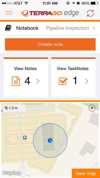
TerraGo Edge version 3.7, now available, includes new intelligent, responsive forms, as well as GPS and GIS enhancements designed to dramatically improve the speed, quality and efficiency of asset inspections, land surveys and any location-based data-collection project.
TerraGo Edge smart forms can accelerate the data-collection process by automating and accelerating user entries while eliminating unnecessary or redundant steps. Smart forms can be customized to meet the workflow requirements of customers in any industry.
New features in version 3.7 include:
Advanced Form Creation with New Smart Forms
Form groups – new form element to organize multiple related fields
Conditional fields – additional fields appear based on user entry of other fields
Barcode and QR code support – instantly scans codes to eliminate manual entry
Calculated fields – calculated result field based on other form field values
Multiple form attachments – ability to attach two or more forms to a single Note
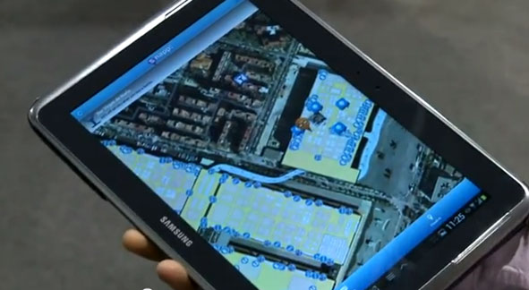
sensewhere’s crowdsourcing technology enables precise location information, with no additional infrastructure, in areas where there is no or inaccurate GPS satellite data such as indoors or in tight urban areas.
Tencent Holdings Ltd., a provider of Internet services in China, has completed a strategic investment in sensewhere Ltd., a provider of indoor location solutions based in Scotland. Tencent has also secured a license to use sensewhere indoor positioning software as part of its Tencent Map Location software development kit (SDK) that is available to numerous users across Tencent mobile platforms and mobile services of Tencent affiliate companies.
The investment will help sensewhere develop potential partnerships in China’s mobile Internet space, deliver its mobile advertising service, fuel expansion of the company and its indoor location solutions. As part of the arrangements, sensewhere will be Tencent’s preferred vendor for location-based advertising services in China.
“This investment by Tencent will be significant for the company and is an endorsement of our technology, strategy and ability to deliver low cost, highly scalable and highly accurate Universal indoor positioning,” said sensewhere CEO Rob Palfreyman. “I am thrilled with the collaboration, and having Tencent as a strategic investor will help take sensewhere to the next level and assist us growing our customer base, building new Location Based Services and investing further in R&D.”
“The investment by Tencent highlights the advantage of sensewhere’s indoor positioning technology over other solutions and further cements our position as a leading Indoor Positioning System (IPS) provider,” said sensewhere Chairman Jim Devine. “The planned roll out of multiple services to millions of users across China and contiguous territories which incorporate sensewhere’s enabling technology represents a major step forward towards our goal of providing a truly global solution for indoor positioning.”
sensewhere believes that its seamless, automatic solution for IPS and easy integration with mobile applications and devices will be the driving force behind emerging technologies, such as automatic beacon mapping, wearable technology, artificial intelligence, mobile advertising and using its live database to power next-generation location-based services.
“We believe that a superior, universal indoor positioning technology will deeply influence how people interact with each other, and significantly change how companies communicate with consumers and conduct commerce indoor across online and offline platforms,” said Julian Ma, corporate vice president of Tencent in Mobile Internet Group. “sensewhere’s unique, highly scalable approach will greatly enhance Tencent Map’s indoor positioning capabilities and enable our users to navigate indoor in a much more accurate and convenient manner.”
The video below explains sensewhere’s indoor location technology.
Garmin International Inc. has expanded its partnership with Honda Motors to provide the infotainment systems in new-model Hondas with Garmin’s navigation system. The latest vehicle platform to launch with Garmin and its navigation solution is the all-new Honda Pilot.
“We are delighted to expand our esteemed partnership with Honda across multiple new vehicle platforms, bringing our navigation expertise to their customers via an integrated system that is feature-packed and easy to use,” said Matt Munn, Garmin managing director of automotive OEM. “This growing partnership is a testament to the reliability and quality of our navigation solutions and we are honored by Honda’s continued confidence in Garmin.”
The Garmin system integrates seamlessly into Honda infotainment consoles. Preloaded maps allow users to navigate through areas that lack cell reception, while millions of points of interest make it easy to find existing or new locations, Garmin said.
Spoken turn-by-turn directions are enhanced with advanced guidance features to navigate drivers through challenging and rigorous circumstances. Lane guidance indicates the proper lane for a driver to make a turn, and photoReal junction view provides photo-realistic images of junctions and exits. The system also includes real-time traffic avoidance, speed limit display, 3D buildings, terrain views and more.