Author: GPS World Staff

  • AT&T and Telogis Expand Efforts to Connect Fleets

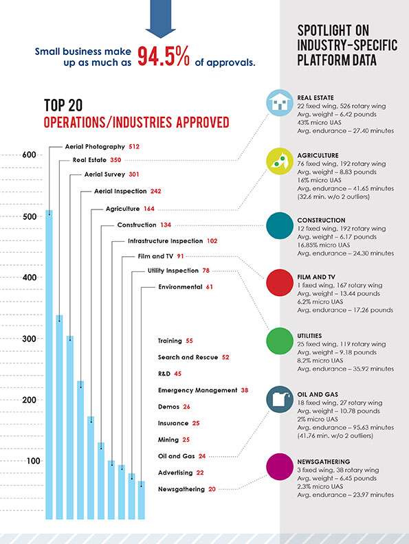
    AT&T and Telogis, a SaaS-based connected vehicle technology provider, have announced a collaboration to offer solutions for companies with mobile workforces. Connecting vehicles of all sizes from small trucks to 18-wheelers and heavy equipment, the combination of AT&T’s global network and Telogis’ telematics, compliance, and mobile and navigation software creates full-fleet solutions for businesses around the world.

    The announcement was made at CTIA Super Mobility, being held this week in Las Vegas.

    Telogis works with some of the world’s largest mobile companies to provide the critical data they need for more informed decisions relating to operational efficiency, reducing costs and improving safety. Telogis is the exclusive connected commercial vehicle technology provider for Ford Motor Company, powering its factory-installed Ford Telematics solution. Telogis also works with General Motors, Hino, Volvo, Mack, Manitowoc Cranes and Isuzu to build its solutions into vehicles and equipment in the factory.

    Working with AT&T, Telogis is implementing a network solution to deliver a reliable, highly secure stream of data nearly anywhere in the world. The AT&T service management platform allows Telogis to easily manage the data, devices and services that support its customers. AT&T also is working with Telogis to help with over the air updates and provide unique split billing capabilities.

    “We’re offering Telogis a complete wireless network that enables two-way, real-time data communication between the vehicle and office,” said Chris Penrose, senior vice president, AT&T Internet of Things (IoT) Solutions. “We look forward to driving new innovative services together in the fleet marketplace and offering true global solutions to our mutual customers.”

    “Telogis provides mission-critical intelligence for some of the world’s largest mobile businesses and automotive manufacturers, and our customers demand the quality and reliability that only a provider like AT&T can deliver,” said David Cozzens, CEO, Telogis. “As we continue to capitalize on a rapidly growing, multi-billion dollar global market for connected vehicle and equipment technologies, AT&T provides the scalable infrastructure and backbone Telogis requires.”

    Read more about AT&T’s announcements at CTIA here.

  • Aerial Photography, Surveying Top FAA-Approved Business Uses for UAS

    Aerial Photography, Surveying Top FAA-Approved Business Uses for UAS

    A Sensefly eXom UAV inspects a structure.
    A Sensefly eXom UAV inspects a structure.

    The Association for Unmanned Vehicle Systems International (AUVSI) today released a report that finds more than 25 types of business operations have been approved by the Federal Aviation Administration (FAA) to fly unmanned aircraft systems commercially in the National Airspace System (NAS). According to the report, aerial photography received the most exemptions followed by real estate and aerial surveying. The report also finds that exemptions have been approved in 49 states.

    “These figures show that businesses across every industry sector have been waiting to use UAS for years and are excited to finally get this technology off the ground,” said Brian Wynne, president and CEO of AUVSI. “From inspecting bridges and power lines to filming movies and supporting emergency services, the applications of UAS are virtually limitless and enable researchers, public agencies and businesses to do things that were previously considered to be impossible.”

    In May 2014, the FAA announced it would consider granting exemptions for certain low-risk commercial UAS applications under Section 333 of the FAA Modernization and Reform Act of 2012. Since then, the agency has received more than 2,700 requests and approved more than 1,400 petitions.

    Chart: The Association for Unmanned Vehicle Systems International (AUVSI)AUVSI analyzed the first 1,000 exemptions approved by the FAA. Specifically, the report finds:

    • The approved exemptions cover more than 25 types of business operations, with aerial photography receiving the most approvals with 512. Real estate followed with 350 exemptions and general aerial surveying with 301 exemptions.
    • Exemptions were approved for operators from 49 states. California received the most with 114, followed by Florida with 97 and Texas with 82.
    • California companies also manufactured the most platforms mentioned in the approvals, totaling 140. Florida followed with 19. In all, 22 states house manufacturers of platforms approved in the first 1,000 exemptions.
    • More than 90 percent of the first 1,000 exemptions were granted to small businesses.
    • Companies that received exemptions generate at least $500 billion to the U.S. economy annually and represent more than 600,000 jobs.

    While the Section 333 process has continued to unlock the potential of UAS technology, AUVSI emphasized that regulating by exemption is no substitute for finalized rules.

    “For the full potential of the UAS commercial market to be realized in the U.S., the FAA needs to finalize its small UAS rule as quickly as possible,” Wynne said. “Once this happens, we will have an established framework for UAS operations allowing anyone who follows the rule to fly. The positive effects of the regulation will be felt across the whole country.”

    An economic impact study released by AUVSI in 2013 found the UAS industry will create more than 100,000 new jobs and more than $82 billion in economic impact within the first ten years following UAS integration.

    The complete study, including state-by-state data, is available.

  • Watch the Launch of Galileo 9 and 10

    Watch the Launch of Galileo 9 and 10

    On Sept. 7, the upper composite containing Galileos 9–10 was transferred to the launch pad, then hoisted up to the top of the Soyuz launch tower to be joined to the other stages.
    On Sept. 7, the upper composite containing Galileos 9–10 was transferred to the launch pad, then hoisted up to the top of the Soyuz launch tower to be joined to the other stages.

    Galileo 9 and 10 are due for launch atop a Soyuz rocket at 02:08 GMT on Sept. 11 (04:08 CEST; 23:08 local time, Sept. 10) from Europe’s Spaceport in French Guiana. Streaming starts at 01:48 GMT (03:48 CEST) on the European Space Agency website. Or watch at Arianespace’s website (with commentary in French or English), starting 15 minutes before liftoff. You can also follow the launch live on your iPhone or iPad using the free Arianespace.tv app.

    The first three stages of the Soyuz rocket take the Galileo satellites and their Fregat upper stage into low orbit. Then the reignitable Fregat, as much a spacecraft as a rocket stage, will take over the task of hauling the satellites higher through a pair of burns.

    The satellites will be released in opposite directions by their dispenser once they reach their set 22 522 km-altitude orbit 3 h 47 min 57 sec after launch.

    The webstream will cover the launch and orbital insertion in two parts, the first starting at 01:48 GMT (03:48 CEST) and ending at 02:40 GMT (04:40 CEST). The second part will begin at 05:43 GMT (07:43 CEST) and end at 06:50 GMT (08:50 CEST).


    Read Richard Langley’s update on the Galileo constellation.


    Two more satellites are scheduled for launch by end of this year. One is under test at ESA’s ESTEC technical centre in Noordwijk, the Netherlands, while the other has already completed its checks and is awaiting shipping to Kourou in the second half of October.

    In addition, the first satellite of the following batch (Galileo-13) is undergoing its thermal-vacuum test at ESTEC, while the second (Galileo-14) arrived on Monday.


    From ESA: Anatomy of a Galileo launch in pictures.


    Hoisting VS12 launcher integration and composite, on Sept. 7. (Photo: CNES)
    Hoisting VS12 launcher integration and composite, on Sept. 7. (Photo: CNES)

    Launch Details from Arianespace

    Orbit: circular medium Earth orbit (MEO)
    Altitude: 23,522 km
    Inclination: 57.4 degrees

    Liftoff is scheduled for Thursday, Sept. 10, 2015, at:

    11:08:10 p.m., local time in French Guiana
    10:08:10 p.m., in Washington, D.C.

    and on Friday, Sept. 11 at:

    02:08:10 UTC
    4:08:10 am, in Paris
    6:08:10 am, in Moscow

    The mission (from liftoff to satellite release) will last approximately 3 hours and 48 minutes.

    The launcher will be carrying a total payload of 1,601 kg, including 1,431 kg for the two Galileo satellites.

    The Launch Readiness Review (LRR) took place on Wednesday, Sept. 9, in French Guiana, to authorize the start of operations for the final countdown.

  • PCTEST Expands Antenna Testing Capabilities with Rohde & Schwarz

    PCTEST Expands Antenna Testing Capabilities with Rohde & Schwarz

    R&S TS8991 Wireless Performance Test Chamber.(PRNewsFoto/Rohde & Schwarz)
    R&S TS8991 Wireless Performance Test Chamber.(PRNewsFoto/Rohde & Schwarz)

    PCTEST Engineering Laboratory, an accredited testing laboratory for wireless testing and certification, has expanded its over-the-air (OTA) conformance testing capabilities with the purchase of a CTIA-compliant R&S TS8991 Wireless Performance Test Chamber (WPTC) from Rohde & Schwarz.

    The R&S TS8991 OTA Test System is configured with hardware and software extensions for legacy and LTE A-GPS, a R&S ZND vector network analyzer for passive antenna measurements and faster system calibrations, and a second antenna boom with additional R&S NRP power sensors for faster total radiated power (TRP) measurements. The entire system is controlled via R&S AMS32 wireless performance software.

    As the number of technologies and the variety of mobile devices continue to increase, the ability to verify a device’s radiated performance is becoming more important to ensure end-user quality of experience. For 4G/LTE, there are major developments involving the Internet of Things, machine-to-machine communication, LTE at 5GHz (LTE-U), assisted global navigation satellite system (A-GNSS), and carrier aggregation, which are driving the need for improved as well as additional OTA tests required for both carrier acceptance and industry conformance test plans.

    “As wireless devices become more specialized and continue to push the boundaries of transmission efficiency, the ability to fully characterize a device in an over-the-air environment is becoming more critical,” said Randy Ortanez, president of PCTEST Lab. “Every day we are seeing the acceptance bar being raised and more test cases defined from operators and standard bodies such as CTIA and 3GPP. To meet these growing demands, we are very pleased to be working with our partner Rohde & Schwarz who is able to deliver and support a complete turn-key solution for our OTA testing needs.”

    PCTEST is exhibiting in the Test Pavilion of Hall C, Booth 5159, at the CTIA Super Mobility trade show, taking place this week at the Sands EXPO in Las Vegas. Rohde & Schwarz is exhibiting in Booth 3249.

  • Tallysman Introduces VeraPhase 6000 High-Precision GNSS Antenna

    Tallysman Introduces VeraPhase 6000 High-Precision GNSS Antenna

    Tallysman's VeraPhase 6000 high-precision GNSS antenna.
    Tallysman’s VeraPhase 6000 high-precision GNSS antenna.

    Tallysman, a manufacturer of high-performance GNSS antennas, announces the commercial availability of the VeraPhase 6000 antenna series, a family of antennas that provides the lowest axial ratios (horizon to horizon, through all azimuths) across all GNSS frequencies (70 percent), a tight PCV (± 1mm through all frequencies, azimuths, and elevations), and a consistent PCO through all frequencies.

    The performance of the VeraPhase rivals that of choke ring antennas, but is much lighter, smaller and more economical, Tallysman said. The antenna family is designed for use in survey, precision RTK and reference antenna applications.

    The VeraPhase 6000 also provides an available PCB within the base of the antenna for integration of a custom system board such as a dual-band or RTK GNSS receivers or other applications.

    The VP6000 family provides high receive RHCP gain over the full GNSS spectrum:

    • low GNSS band (1164 MHz to 1300 MHz)
    • L-band correction services (1525 MHz to 1559 MHz)
    • high GNSS band (1559 MHz to 1610 MHz).

    Each model features a robust, high IP3, pre-filtered LNA to minimize desensing from high-level out-of-band signals, including 700 MHz LTE, and that yet still provides a noise figure of less than 2.5 dB. Non-pre-filtered versions are also available with a noise figure of less than 1.5 dB.

    The VP6000 antenna family is available in three formats:

    • A survey-grade all-band antenna that provides 35-dB LNA gain and is available with a robust rubber bumper for field use.
    • An all-band base station antenna is available with 35-dB LNA gain or with an internal 15-dB pre-filtered pre-amp for OEM applications.
    • An all-band reference antenna that features a 50-dB gain LNA, a conical radome to shed snow ice and birds, and is available with a robust monument mount for sub-millimeter precision.

    Each antenna has a well defined phase centre offset relative to the antenna reference plane.

    The base housing of the VP6000 is IP67-compliant and weighs less than 700 grams. The antenna is 167 millimeters wide at the top, 110 millimeters wide at the base and 110 millimeters in height. Each model has a 5/8-inch x 11 TPI thread for mounting and is available with either a TNC or an N-type connector.

    A white paper is available on Tallysman’s website.

    Tallysman’s booth at INTERGEO is in Hall E8, Booth 038. Follow GPS World on Twitter for the latest news from INTERGEO.

  • Kika M2M Launches Theft AL3RT for Polaris eBikes

    Kika M2M Launches Theft AL3RT for Polaris eBikes

    The AL3RT asset tracker is designed for the power sports industry and runs on the AT&T network.
    The AL3RT asset tracker is designed for the power sports industry and runs on the AT&T network.

    Kika Enterprises announced at CTIA Super Mobility this week that its AL3RT asset protection unit will be available as an accessory for Polaris electric bikes worldwide, beginning January 2016. The AL3RT trackers will be sold at sports dealerships in the United States.

    Powered by AT&T, AL3RT is a stand-alone, customizable asset locator and fleet management tool designed for theft protection of on- and off-road vehicles, motorcycles, snowmobiles and personal watercraft.

    AL3RT customer benefits include: real-time location alerts, anti-theft alerts, accident panic alerts, historical location data, coverage in locations around the globe, long battery life (up to seven days) and a water- and dust-proof housing. The product line will also include several accessories, such as a multi-use cradle for easy mounting and Bluetooth multi-sensors that can be programmed individually.

    Supported by GPS, GSM, Wi-Fi and Bluetooth technologies, users can use their AL3RT smartphone app to locate their asset, as well as arm and disarm sensors and configure geofences virtually anywhere in the world. AL3RT can be configured to send individual or group alerts via email or SMS.

    “We are excited about the launch of the AL3RT, because it represents the first true anti-theft alert solution designed for the power sports industry,” commented Ricardo Salguero, president of Kika M2M. “The AL3RT offers superior features, reliability and AT&T connectivity, making it a tremendous extension of our growing line of customizable M2M solutions. This addition truly positions Kika M2M uniquely in the market with a broad range of proprietary M2M solutions for the power sports industry.”

    Kika M2M will showcase the AL3RT at CTIA Super Mobility, taking place Sept. 9-11 in Las Vegas, as a part of AT&T’s Booth #3724.

  • Spirent to Demo GSS9790 Simulator in ION GNSS+ Session

    Spirent Federal Systems will demonstrate its GSS9790 simulator at ION GNSS+, taking place Sept. 14-17 in Tampa, Fla.

    The Spirent demonstration “Interference and Anti-jam Antenna Testing Using the Spirent Wavefront Simulator (GSS9790)” will take place in Room 17 on Thursday, Sept. 17, 2-2:45 p.m. Attendance gains one ticket for an Apple Watch raffle, with the winner to be announced Thursday at 4 p.m., Booth C in the Exhibit Hall.

    The ability of a CRPA to null out unwanted signals while still allowing wanted signals to be received is key to its performance. This ability allows GNSS receivers to continue to operate in challenging signal environments, Spirent said in an email. The similar but slightly different signal composition at each antenna element allows the CRPA to distinguish direction for wanted and unwanted signals. Recreating this signal environment in an anechoic chamber is critical in allowing the discerning test professional to rigorously evaluate the performance of a CRPA system.

    The Spirent GSS9790 is designed for this testing. The 9790 allows for code, carrier and amplitude control on a satellite-by-satellite and interferer-by-interferer basis.


  • Spirent Partners with Nottingham Scientific for Robust PNT

    Spirent Partners with Nottingham Scientific for Robust PNT

    Spirent Communications has entered into a strategic partnership with Nottingham Scientific Limited (NSL) to enable the detection, characterization and regeneration of threats to GNSS receiver systems.

    NSL is one of the companies in Europe involved in satellite navigation, specializing in developing reliable and robust GNSS technologies for a variety of applications, such as those that impact safety or are critical in terms of business, finance and security. NSL has carried out many successful GNSS research programs within the UK and internationally for government organizations, regulators and policy makers, Spirent said.

    Martin Foulger (left), general manager at Spirent Communications, meets with Mark Dumville, general Manager of NSL, at NSL's headquarters in Nottingham, UK. (Photo: Spirent)
    Martin Foulger (left), general manager at Spirent Communications, meets with Mark Dumville, general Manager of NSL, at NSL’s headquarters in Nottingham, UK. (Photo: Spirent)

    The combination of NSL’s acknowledged expertise in the research of GNSS vulnerabilities with Spirent’s leadership in GNSS simulation and test development enables the provision of a range of planned robust positioning, navigation and timing (PNT) solutions.

    “Threats to GNSS and related PNT applications are becoming more orchestrated and coordinated, with the motivation to disrupt or cause financial loss becoming the driving factor,” said John Pottle, marketing director at Spirent’s Positioning division. “Real-world threats are wide-ranging and affect navigation and timing system performance differently. Our partnership with NSL enables not only detection, but also regeneration, of real threats in the lab. This allows users to understand which threats are most relevant to them, and informs decisions on improving robustness.”

    “NSL and Spirent share a vision that building robust position, navigation and timing systems is enabled through evaluating system performance against a real threats baseline” Mark Dumville, general manager at Nottingham Scientific Ltd, said. “By auditing system performance, decisions on how to improve resilience can be based on facts, not guesswork.”

  • GSA Launches Funding for Galileo Chipsets, Receivers

    The European GNSS Agency (GSA) has launched a new research and development funding mechanism supporting development of Galileo chipsets and receivers, intended to enable the adoption of Galileo and EGNOS-powered services across all market segments. The Fundamental Elements programme supports activities that will be carried out from 2015-2020 with a projected budget of EUR 100 million.

    Fundamental Elements is part of an overall strategy of market uptake initiatives led by the GSA and in accordance with EU regulation.

    “For the first time, EU regulation provides a financing tool for the market uptake of European GNSS chipsets and receivers,” said GSA Executive Director Carlo des Dorides. “The GSA will be instrumental in ensuring that the new Fundamental Elements programme contributes to the successful integration of Galileo and EGNOS.”

    Fundamental Elements complements the EU’s Horizon 2020 research programme. While Horizon 2020 aims to foster adoption of Galileo and EGNOS via content and application development, Fundamental Elements projects will focus on supporting the development of innovative chipset and receiver technologies.

    Fundamental Elements will provide two types of financing: grants and procurement. Grants will be provided with financing currently foreseen for up to 70 percent of the total value of the grant agreement. Intellectual property rights will stay with the beneficiary under the condition that the developed product is aimed at commercialization.

    In the case of grants, the GSA publishes two annual Grant Plans, one for EGNOS and another for Galileo. These plans indicate the envisaged grants to be awarded per year. The Fundamental Elements grants are included in these plans and can be consulted before the publication of the Call for Proposals. The annual Grant Plans include a brief description of the projects and the indicative budget and timings. Procurement will be used only in cases where keeping intellectual property rights allow for the better fulfillment of the programme’s objectives.

  • Federal Register Notice Seeks Comments on GPS L1 Band Interference Test Plan

    Federal Register Notice Seeks Comments on GPS L1 Band Interference Test Plan

    UPDATE (9/10/15): A public workshop will be held in Washington, D.C., on Oct. 2 to provide an opportunity to discuss the draft test plan and address questions before the close of the public comment period.  The workshop will be held in the RTCA NBAA/Colson Room, 1150 18th St. NW, Suite 910, Washington, D.C., 20036. Click here to register for the workshop.


    The U.S. Department of Transportation today published a Federal Register Notice seeking public comment on a draft test plan for the GPS Adjacent Band Compatibility Assessment effort. The plan aims to obtain interference tolerance masks for GNSS receivers in the L1 radiofrequency band (1559-1610 MHz).

    The objective of the test is to collect data to determine Interference Tolerance Masks (ITM) for categories of GPS and GNSS receivers processing signals in the 1559-1610 MHz Radionavigation Satellite Service (RNSS) frequency band, as well as receivers that process Mobile Satellite Service (MSS) signals to receive differential corrections.

    Demand for commercial spectrum to support broadband wireless communications — in particular, LightSquared — has led the government to consider repurposing various radio frequencies, including the satellite communications bands next to GPS. The ITMs will be used to assess the adjacent band interference power levels that can be tolerated by GNSS receivers processing desired signals in the RNSS band.

    The document outlines the requirements, the overall test plan, and the associated output data needed to successfully perform this component of the GPS Adjacent Band Compatibility assessment.

    The plan can be downloaded here. Deadline for comments is Oct. 9.

    In December 2012, the DOT developed its GPS Adjacent Band Compatibility Assessment Plan that identifies the processes to:

    • Derive adjacent-band transmitter power limit criteria for assumed new applications necessary to ensure continued operation of GPS services, and
    • determine similar levels for future GPS receivers utilizing modernized GPS and interoperable GNSS signals.

    The DOT has previously held three public workshops to discuss the Adjacent Band Compatibility Assessment.

  • UNB GAPS for Precise Point Positioning Gets Update

    The next version of the UNB GPS Analysis and Positioning Software (GAPS), version 5.9.1, is now available.

    The new version of the precise point positioning software includes several updates and new features, including creation of GAPS Basic and Advanced user submission pages.

    The GAPS Basic user submission page allows for quick and easy submission of observation files for users who frequently use GAPS’ default processing options.

    The GAPS Advanced user submission page includes:
    •    User-selection of the orbit and clock products to be used.
    •    User-selection of the carrier-phase and pseudorange observables to be used.
    •    Optional use of GPS L2C in place of P2 for all satellites currently transmitting L2C.
    •    Optional use of GPS L5 in place of L2 for all satellites currently transmitting L5.
    •    Optional use of static-mode satellite clock interpolation (if 30s clock product is used and logging interval < 30s).
    •    User-selection of GDOP cut-off threshold.
    •    User-selection of positional convergence condition and maximum number of iterations for least-squares filter.
    •    Enhanced the cycle-slip detection algorithm (following Blewitt, 1990).
    •    A minimum of 4 satellites per epoch are required before estimation begins.
    •    User-selection of all available neutral atmosphere delay (NAD) prediction model and mapping function (MF) combinations.

    NAD prediction models include: UNB-VMF1 (NCEP), UNB-VMF1 (CMC), VMF1 (ECMWF), UNB3m, GPT2 (1×1 deg.), ESA 2.5 and None

    Mapping function options are: Vienna MF and Niell MF.

    •    User option to not estimate NAD.
    •    User option to not estimate tropospheric gradients.
    •    Optional use of a user-provided receiver antenna calibration file.
    •    NAD estimation automatically terminated if receiver rises above neutral atmosphere threshold (50,000 ft = 15,240 m).
    •    Added option to estimate precipitable water (if a meteorological file is submitted).
    •    New .ion, .cmp, .nad, and .DOP output files as well as modified formatting of the .par file.
    •    Improved reporting of processing parameter options and results in the HTML output.
    •    Added receiver clock and DOP plots.
    •    Added height component to kml output.

    For information on the processing strategy, visit the web page. Your feedback (suggestions, bug reports, etc.) is welcome via the GAPS Development Team email: [email protected].


  • KVH Inertial Solutions Showcased at ION GNSS+

    KVH Inertial Solutions Showcased at ION GNSS+

    KVH_1775_IMU-WKVH is a fiber optic gyro (FOG) manufacturer that controls every aspect of its fiber-optic technology — from drawing its own specialized polarization-maintaining fiber to building precision FOGs and FOG-based inertial systems.

    KVH will be showcasing its FOG-based inertial measurement units (IMUs) at this year’s ION GNSS+ conference, taking place Sept. 14-18 in Tampa, Fla.

    Many of today’s demanding applications require high-performance inertial sensors that provide consistent and reliable accuracy — and strike the right balance between performance, size/weight, power consumption, and price, KVH explained. The company offers three IMUs:

    • 1775 IMU – Premium performance for critical applications
    • 1750 IMU – Advanced performance and versatility
    • 1725 IMU – Superior performance at MEMS prices

    KVH will be at booth 516 in the ION GNSS+ Exhibit Hall.

    Below is a video tour of KVH’s high-performance fiber-optic gyro manufacturing facility, which shows how precision, quality and accuracy are built into each KVH sensor.