
Author: GPS World Staff

  • Nationwide Differential GPS Shutdown Proposed, Comments Sought

    oceantides
    Twenty-two NDGPS sites that serve coastal areas would remain operational under the proposal.

    An Aug. 18 Federal Register notice proposes shutting down the Nationwide Differential Global Positioning System (NDGPS) in January 2016 because of a decline in its use, except for sites in coastal areas.

    The notice, issued by the U.S. Coast Guard (USCG), Transportation Department (DOT) and Corps of Engineers (USACE), reads:

    The Nationwide Differential Global Positioning System (NDGPS) service augments GPS by providing increased accuracy and integrity using land-based reference stations to transmit correction messages over radiobeacon frequencies. The service was implemented through agreements between multiple federal agencies including the  USCG, DOT, and Army Corps of Engineers, as well as several states and scientific organizations, all cooperating to provide the combined national DGPS utility.

    However, a number of factors have contributed to declining use of NDGPS and, based on an assessment by the Department of Homeland Security, DOT and USACE. DHS, DOT and USACE are proposing to shut down and decommission 62 DGPS sites, which will leave 22 operational sites available to users in coastal areas.
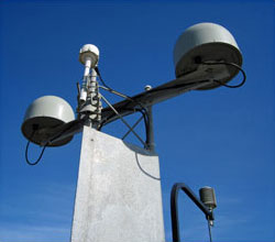
    A DGPS reference station antenna.
    A DGPS reference station antenna.

    Contributing factors cited in the decision are:

    • USCG changes in policy to allow aids to navigation (ATON) to be positioned with a GPS receiver using Receiver Autonomous Integrity Monitoring (RAIM), which assesses the integrity of a GPS signal within the receiver;
    • increased use of Wide Area Augmentation System (WAAS) in commercial maritime applications, which uses ground-based reference stations and satellite communications to improve accuracy;
    • limited availability of consumer-grade NDGPS receivers;
    • no NDGPS mandatory carriage requirement on any vessel within U.S. territorial waters;
    • the May 1, 2000 Presidential Directive discontinuing GPS Selective Availability
    • continuing GPS modernization; and
    • the DOT Federal Railroad Administration’s determination that NDGPS is not a requirement for the successful implementation of Positive Train Control (PTC), which provides the railway system the capability to positively enforce movement authorities along railroad systems.
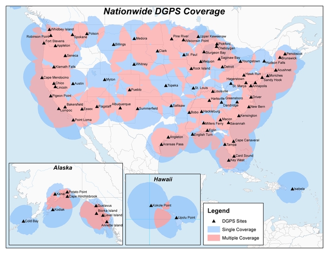
    US_NDGPS_Coverage_APR29_SmIn April 2013, announced that DHS and DOT were in the process of analyzing the need for NDGPS. “The response to the 2013 notice was limited, but the responses received were well informed on the NDGPS system, its use, and current and potential applications,” the notice reads. “While a limited number of responders found the broadcast of corrections to be beneficial, no respondents reported the discontinuance of DGPS broadcast to be detrimental or harmful. Ship pilots in particular noted that DGPS can be critical in confined waterways for precise ship-handling maneuvers.”

    Public comments on the proposed shutdown and decommissioning of 62 DGPS sites are being accepted until Nov. 16. Termination of the NDGPS broadcast at these sites is planned to occur on Jan. 15, 2016.

    Full details on how to submit public comments can be found on the Federal Register page.
  • New GNSS Market Report Assesses 2020 Outlook

    A new GNSS market research report by research firm RNCOS forecasts the global core GNSS market to grow at a Compound Annual Growth Rate (CAGR) of 9 percent during 2015-2020.

    The GNSS industry includes technology that allows any user having a compatible device to determine their position, velocity and local time by processing signals from satellites in space. Signals include GPS, Galileo, GLONASS, BeiDou and regional SBAS. The GNSS market includes both products (receivers and devices) and services using GNSS-based positioning as a significant enabler.

    In the latest research study “Global Navigation Satellite Systems Market Outlook 2020,” analysts identify and decipher the market dynamics in important segments, highlighting the areas offering promising possibilities for companies to boost their growth. The report studies the market by its major application and location-based services, transportation (further divided into road navigation, rail navigation, air navigation and marine navigation), surveying activities and agriculture.

    The GNSS application market is further studied by region — North America, Europe, Asia-Pacific, and Rest of World. 

The report provides a complete overview of the GNSS market globally. All the current trends and drivers coupled with potential growth areas of the GNSS industry have been evaluated in the report. Furthermore, the report provides knowledge of opportunities in the industry for different companies in the “Opportunity Assessment” chapter.

    Additionally, to provide an exhaustive knowledge of the prospects for GNSS players on the geographical front, the report provides a comprehensive knowledge of the 10 most worthwhile GNSS markets around the world: U.S., Canada, UK, France, Germany, Russia, Japan, China, South Korea and India. It includes information about the present state and future outlook of the LBS and telematics market in these countries, along with information about their personal navigation systems with the U.S.’s GPS, China’s BeiDou, Europe’s Galileo, Russia’s GLONASS, Japan’s QZSS and India’s IRNSS.

    Finally, the study looks into the competitive landscape covering business overviews, key financials, product analyses, recent developments and strengths and weaknesses analyses of each of the players. All in all, the report is intended to help clients analyze the driving forces and understand the opportunities in the industry.

    The full report is available from Report Buyer.

  • Trimble Launches VRS Now Service in Georgia

    Trimble has launched Trimble VRS Now correction service in Georgia. The commercial subscription service provides surveyors, civil engineers, and geospatial professionals in the region with instant access to real-time kinematic (RTK) GNSS corrections without the need for a base station.

    Using both the GPS and GLONASS constellations, the Trimble service delivers centimeter-level RTK corrections customized for each GNSS receiver’s location anywhere in the network via cellular communications. The Trimble VRS Now service supplies accurate, reliable and easy-to-use GNSS positioning for a variety of applications including surveying, urban planning, urban and rural construction, environmental monitoring, resource and territory management, disaster prevention and relief, and scientific research, Trimble said.

    “As we continue to expand our VRS Now network throughout the U.S., we’re excited to offer users in Georgia state-of-the-art VRS correction services powered by the latest Trimble infrastructure technology,” said Lisa Wetherbee, business area director of Trimble’s Positioning Services Division. “Now seamless coverage is available across Georgia, Alabama and Florida providing customers with reliable centimeter-level accuracy and the flexibility to work more freely across a larger tri-state coverage area.”

    Service in Georgia is a continuation of Trimble’s focus on providing solutions that enable customers to increase productivity by simplifying access to high-precision positioning around the world. Similar VRS Now services are operating in Illinois, Indiana, Iowa, Nebraska, Colorado, Florida, Alabama, Mississippi, Texas, Oregon, New Mexico and parts of Europe and Australia.

  • Airbus, Lime Microsystems Partner on Robust Galileo Receiver

    Lime Microsystems and Airbus Defence and Space, with funding from Innovate UK (formerly the Technology Strategy Board), will jointly be developing robust GNSS products, according to a Lime Microsystems blog. Airbus D&S, using Lime’s Field Programmable RF (FPRF) transceiver technology, is developing a robust timing receiver that exploits signals from the new Galileo satellite navigation constellation.

    A highly integrated Field Programmable RF (FPRF) solution based on Lime’s technology, and an innovative system implementation of the kind provided by Airbus D&S, will provide a high-performance GNSS product with the potential for integration with other wireless capabilities, the companies said.

    “Lime FPRF transceiver matches our rigorous technical performance requirements and we are looking forward to be working alongside Lime in this strategic engagement,” said Mike Turner, Airbus D&S.

    “We are delighted to be working with Airbus, supporting a complimentary technology that could impact variety of applications such as wireless infrastructure,” said Ebrahim Bushehri, CEO of Lime Microsystems.

  • Qualcomm Completes $2.4 Billion Acquisition of CSR

    Qualcomm Incorporated announced Thursday that its subsidiary Qualcomm Global Trading Pte. Ltd. has completed the acquisition of CSR. CSR is known to the GPS/GNSS industry as the maker of the SiRFstar series of chips, which are used in many consumer devices.

    Qualcomm started the acquisition process for CSR in October 2014. With this close of the acquisition, Cambridge Silicon Radio Limited, or CSR, is renamed Qualcomm Technologies International Ltd.

    The acquisition, which was completed at an enterprise value of approximately $2.2 billion, complements Qualcomm Technologies, Inc.’s offerings by adding a compelling portfolio of new products, sales channels and a large number of customers in the areas of IoE and automotive — both key growth priorities for Qualcomm Technologies.

    Cambridge Silicon Radio Limited is an indirect, wholly-owned subsidiary of CSR that operates, along with its affiliates, substantially all of CSR’s engineering, research and development functions, along with substantially all of the CSR products and services businesses. Cambridge Silicon Radio Limited will be renamed Qualcomm Technologies International, Ltd., which will become a subsidiary of Qualcomm Technologies.

    “As we strive to connect billions more devices, automobiles and people within the Internet of Everything, we are enthusiastic about the growth that this combination will foster,” said Steve Mollenkopf, chief executive officer, Qualcomm Incorporated. “CSR’s complementary strengths in connectivity, audio technologies and systems-on-chips will help strengthen Qualcomm Technologies’ position in the IoE and automotive industries, and add to a broad and highly advanced portfolio.”

    “We are pleased to join a recognized leader such as Qualcomm Technologies at an exciting time as customers race to satisfy the growing consumer desire for more and more seamlessly connected devices in their ‘smart’ homes, offices and cars,” said Joep van Beurden, chief executive officer, CSR. “Our employees have a strong history of pioneering new products and collaborating with customers to deliver critical technology requirements such as interoperability, low power and connectivity. Together with Qualcomm Technologies, we are better positioned to meet our customers’ needs today and into the future.”

    While the accounting for the transaction is not yet finalized, Qualcomm estimates that on a Non-GAAP basis the acquisition will be modestly accretive to earnings per share in fiscal 2016 consistent with prior guidance. In addition, based on preliminary estimates, Qualcomm expects the transaction to be modestly dilutive to GAAP earnings for fiscal 2016 driven primarily by acquisition-related items.

  • Newest BeiDou Satellites Begin Operating

    The two BeiDou satellites launched July 25 are now operating autonomously, according to the news site English.news.cn. The satellites were launched by a Long March III-B rocket from the Xichang Satellite Launch Center in Sichuan Province, southwest China. The twin satellites, dubbed BEIDOU-3 M1 and BEIDOU-3 M2, surpass their predecessors in speed, accuracy and weight, according to the news agency.

    China has successfully tested the autonomous control technology of the Beidou constellation, said to Xie Jun, chief designer of Beidou navigation satellite system. “The biggest difficulty is the autonomous navigation technology,” Xie said. “We need it to maintain the sustainable development of the project.”

    Wang Ping, another chief engineer on the project, says the inter-satellite link realizes communication and distance measurement among satellites, bringing autonomous control of the navigation system a step closer.

    China plans to set up a complete constellation of 35 satellites, achieving global coverage by 2020.

  • Registration Opens for International Symposium on GNSS

    Registration Opens for International Symposium on GNSS

    Kyoto-banner-TRegistration is now open for the International Symposium on GNSS (IS-GNSS 2015), which will be held Nov. 16-19 in Kyoto, Japan. The early bird registration deadline has been extended and closes Aug. 31, and regular registration is Sept. 1-Oct. 31.

    The International Symposium on GNSS is designed to bring together experts engaged in PNT and GNSS technologies — including industry professionals, practitioners, academics and researchers — to disseminate their latest research results and allow cross-disciplinary exchange of knowledge to further advance the fields.

    Brad Parkinson will deliver the keynote address. Besides keynote addresses, the conference will feature oral presentations, interactive poster sessions, panel sessions, open interactive forums and an informative trade exhibition.

    The Asia and Pacific Rim meeting of the CGIC (Civil GPS Service Interface Committee) will be co-located with ISGNSS 2015 to help improve understanding of world trends in developing and deploying GNSS.

    Kyoto is the ancient capital of Japan and a top tourist destination, organizers said, with the conference scheduled during the best sightseeing season.

    Registration will open April 1, along with a hotel booking page. The logistic information will be announced later.

    A student scholarship is being offered to the student with the most promising paper. “If you have students, please encourage them to apply,” said Akio Yasuda, president of Institute of Positioning, Navigation and Timing of Japan.

    For more information on the conference, including sponsorships and exhibits, visit the conference website or email [email protected].

  • Canada to Supply MEOSAR Search and Rescue Repeaters to GPS III

    Canada to Supply MEOSAR Search and Rescue Repeaters to GPS III

    The Canadian government will begin providing search-and-rescue repeaters for the U.S. Air Force’s GPS III satellites, reports Space News. The repeaters provided by Canada’s Medium Earth Orbit Search and Rescue (MEOSAR) satellite project will significantly reduce the time it takes to locate a distress signal.

    Canada’s Department of National Defence will begin negotiations with the U.S. Air Force to install 24 repeaters on GPS III satellites, starting with the 11th GPS III satellite. Canada’s MEOSAR satellite project includes construction of three ground stations, to be built by 2020.

    The MEOSAR satellite payload is being developed for GPS III satellites.
    The MEOSAR satellite payload is being developed for GPS III satellites.

    The Canadian government first announced the MEOSAR project in 2013, awarding Com Dev International of Cambridge, Ontario, an initial contract worth 4.7 million Canadian dollars for research and design work on the repeaters. Despite completion of that phase, Canada’s Department of National Defence put the project on hold, possibly for budgetary reasons.

    A contract award for the MEOSAR repeaters is now expected to be announced next year.

    A MEOSAR repeater will be able to detect signals from emergency beacons and retransmit the signals to receiver stations on the ground. The emergency messages can then be sent to appropriate authorities so that people in danger can be quickly located and rescued.

    MEOSAR will provide a more capable system than COSPAS-SARSAT, an international satellite-based search and rescue distress alert detection system established by Canada, France, the former Soviet Union and the United States in 1979. It is credited with saving more than 33,000 lives since its inception. MEOSAR will reduce the time it takes to detect and locate a distress signal from an hour to around five minutes.

    Com Dev began the development of its MEOSAR technology in 2008 under a cost-shared research and development project with the Canadian Space Agency. Canada’s National Search and Rescue Secretariat also later provided additional R&D support.

    The search and rescue transponders were originally destined for Galileo, according to Space News, but stalled because Canada lacked a defense certificate to be able to supply the Galileo program.

    For background on the MEOSAR program, see the January 2011 Innovation column, “The Distress Alerting Satellite System.”

  • Most Railroads Will Miss Positive Train Control Deadline

    Most railroads will miss the Dec. 31, 2015, deadline for implementing positive train control (PTC), according to a report submitted to the U.S. Congress by the Federal Railroad Administration (FRA). Congress established the deadline in 2008.

    An automatic train control system — many of which use GPS — was not installed on the commuter rail route where an Amtrak train left the track in May.

    The FRA sent its “Status of Positive Train Control Implementation” report to Congress this week. The report is mandated by the House of Representatives Appropriations Committee.

    “Positive train control is the most significant advancement in rail safety technology in more than a century,” U.S. Transportation Secretary Anthony Foxx said. “Simply put: it prevents accidents and saves lives, which is exactly what we seek to do at the Department of Transportation every single day. We will continue to do everything in our power to help railroads install this technology.”

    The National Transportation Safety Board (NTSB) began calling for train control systems like PTC in 1969, and the FRA was involved in establishing PTC standards with stakeholders for more than a decade before the 2008 mandate. Three years before Congress passed the PTC mandate, the FRA issued its final rule that established uniform PTC standards for railroads willing to voluntarily install the technology.

    Positive train control prevents train-to-train collisions, over-speed derailments, incursions into established work zone limits and a train going to the wrong track because a switch was left in the wrong position.

    In 2008, Congress passed the Rail Safety Improvement Act, requiring all Class I railroads transporting poisonous-by-inhalation hazardous (PIH) or toxic-by-inhalation hazardous (TIH) materials, and all railroads providing passenger service, to implement Positive Train Control by Dec. 31, 2015.

    The FRA has provided assistance and support to railroads to help them become PTC compliant. Those efforts include:

    • Providing more than $650 million to passenger railroads, including nearly $400 million in Recovery Act funding.
      Issuing a nearly $1 billion loan to the Metropolitan Transportation Authority to implement PTC on the Long Island Rail Road and Metro-North.
    • Building a PTC testbed in Pueblo, Colo.
    • Working directly with the Federal Communications Commission and the Advisory Council on Historic Preservation to resolve issues related to spectrum use and improve the approval process for PTC communication towers.
    • Dedicating staff to continue work on PTC implementation in March 2010, including establishing a PTC task force.

    “The Federal Railroad Administration will continue to use its resources and expertise to help railroads achieve the critical goal to have Positive Train Control implemented,” FRA Acting Administrator Sarah Feinberg said.

    Read the full report.

  • UAV Interference with Aircraft Much Higher in 2015

    UAV Interference with Aircraft Much Higher in 2015

    Cover: National Interagency Fire CenterThe Federal Aviation Administration (FAA) wants to send out a clear message that operating drones around airplanes and helicopters is dangerous and illegal. Pilot reports of unmanned aircraft have increased dramatically over the past year, from a total of 238 sightings in all of 2014, to more than 650 by Aug. 9 of this year. Unauthorized operators may be subject to stiff fines and criminal charges, including possible jail time.

    Pilots of a variety of different types of aircraft — including many large, commercial air carriers — reported spotting 16 unmanned aircraft in June 2014, and 36 the following month. This year, 138 pilots reported seeing drones at altitudes of up to 10,000 feet during the month of June, and another 137 in July.

    Meanwhile, firefighters battling wildfire blazes in the western part of the country have been forced to ground their operations on several occasions for safety reasons when they spotted one or more unmanned aircraft in their immediate vicinity.

    The FAA says it will continue to work closely with industry partners through the “Know Before You Fly” campaign to educate unmanned aircraft users about where they can operate within the rules. The agency is also supporting the National Interagency Fire Center’s “If You Fly, We Can’t” efforts to help reduce interference with firefighting operations.

    However, the FAA also is working closely with the law enforcement community to identify and investigate unauthorized unmanned aircraft operations. The FAA has levied civil penalties for a number of unauthorized flights in various parts of the country, and has dozens of open enforcement cases.

    The FAA encourages the public to report unauthorized drone operations to local law enforcement and to help discourage this dangerous, illegal activity.

  • Satel Joins with Antenna Maker Welotec at INTERGEO

    Satel Joins with Antenna Maker Welotec at INTERGEO

    Photo: Satel

    Finnish radio data communication specialist Satel will present innovative new products for mission-critical radio data networks at INTERGEO, being held in Stuttgart, Germany, Sept. 15-17.

    In Germany, radio data communication solutions from Satel are distributed by the full-range and systems provider Welotec. At the trade fair in Stuttgart, the partners will present their products at adjacent stands. Both Satel as a radio data communication specialist and Welotec as a full-range and systems provider have a strong portfolio for the core market of RTK/GNSS, UAV and RPAS (remotely piloted aircraft systems) applications.

    By 2020, Satel intends to be the world’s number one provider of mission-critical data connections, it said in a statement. This goal also includes becoming the technology leader, which the company hopes to achieve through intensified research and development.

    At INTERGEO, Satel will present its latest products. Visitors will be able to see the OEM modules Satelline-M3-TR1 and Satelline-M3-TR4. These modules allow use of the frequencies requiring a license (330 – 473 MHz) as well as the European license-free frequency ranges (433.05 – 434.79 MHz and 869.400 – 869.650 MHz).

    The newly developed Satelline-M3-TR4 is the smallest available data transceiver module in its class, according to Satel. The Satel Compact-Proof is a portable radio data modem with a rechargeable battery and a flexible tuning range (403 – 473 MHz). The robust Satelline EASy Pro 25W, likewise with a broad tuning range (403 – 473 MHz), allows radio communication up to a range of 50 km, which makes it quite versatile.

    Welotec offers a large range of antennas that supplement the Satel radio data modems. The antennas cover a large frequency range from 68 MHz to 6000 MHz, indoor and outdoor applications, MIMO technology and also antennas with an operating range from minus 40 degrees Celsius to 80 degrees C for use in harsh environments. At INTERGEO, visitors will see innovative solutions from Welotec in the area of industrial communication — for example, the industrial UMTS, LTE and WLAN routers of the TK800 series or the high-performance Industrial-WLAN access point DM500. For measuring tasks, Welotec offers the laser distance sensor OWTB V2.1, which features an extremely high resolution and ranges of up to 500 meters for industrial applications.

    Satel and Welotec will be at INTERGEO 2015 in Stuttgart in Hall 4, Booth G4.020. GPS World is covering INTERGEO live — visit gpsworld.com and follow us on Twitter and Facebook.

  • Fugro Expands Survey Services and Satellite Imagery Capabilities

    Fugro has extended its integrated survey services to help improve efficiency in coastal management and enable more informed decision-making. A new agreement with global specialist EOMAP enables the creation of integrated bathymetric survey products that comprise elements from Satellite Derived Bathymetry (SDB), Airborne LiDAR Bathymetry (ALB) and traditional acoustic survey technologies. The integrated data and product solutions will provide clients with outstanding value and unmatched coverage, Fugro said.

    “Teaming with EOMAP augments our considerable survey and satellite imagery capabilities and will allow a timely and cost-effective nearshore bathymetry review facility for clients whose own bathymetric holdings are either very old or very sparse — or both,” said Don Ventura, hydrographic business development manager at Fugro. “This service will help coastal zone management and engineering teams, environmental scientists and hydrographic agencies to focus on their immediate needs and to make more informed decisions on subsequent, efficient data acquisition and management.”

    EOMAP’s robust technology platform can process satellite images and deliver global bathymetric and benthic habitat data over the full range of temporal and spatial resolutions through its proprietary, sensor-independent Modular Inversion Processor (MIP). This both complements and augments services already provided by Fugro, to provide even more spatial data solutions to suit a wide variety of budgets and purposes.

    “We are very pleased to provide our Satellite Derived Bathymetric products and services to Fugro,” said Matthew Bergin, Vice President of Business Development at EOMAP. “We believe that this agreement will create a unique, one-stop technology resource to meet the demanding requirements of both commercial and government customers.”