GPS World staff will cover the 2015 INTERGEO Trade Show, being held Sept. 15–17 in Stuttgart, Germany. The show opens with keynote speeches by Chris Cappelli (Esri) on location platforms and Georg Gartner (Vienna University of Technology) on the future of the map.
INSPIRE examines geo-issues from a European perspective, providing practical examples and focusing on further development of this European directive. Other central themes include geodata as a basis for construction management and land development, as well as issues relating to property markets and valuation.
A panel discussion on the second day tackles geospatial Information with a high-profile panel of speakers: Bengt Kjellson (UN-GGIM Europe), Ola Rollen (Hexagon), Steve Berglund (Trimble) and Chris Cappelli (Esri). Another key topic is geoinformation and mobility. DDGI and DVW will be addressing this together and discussing practical examples in two event strands.
A Big Data discussion focuses on the rapid development of data capture, processing and presentation as well as the direct integration of data into business processes.
As important as data may be in the digital world, it is also crucial to have the right visualization concepts in place. This will be demonstrated through presentations on German Cartographers’ Day, which will form part of INTERGEO.
Tap into our up-to-the-minute show coverage here at gpsworld.com and via Twitter (@GPSWorld). Below are the GPS World videos from INTERGEO 2014.
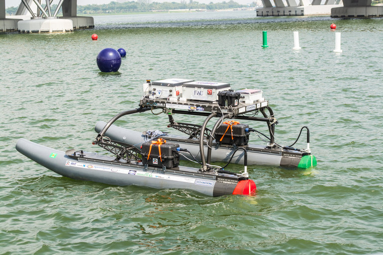
A research team at Florida Atlantic University’s (FAU) College of Engineering and Computer Science has received a $187,000 grant from the Florida Department of Transportation (FDOT) to develop autonomous waterborne vehicles that can assist in bridge inspections.
Although the technology is still in the early stages of development, the long-term aim is that the unmanned surface vehicles (USVs) could be used by the agency to make bridge inspectors’ work safer and more efficient, according to GovTech.com. FDOT currently uses a variety of methods and equipment to inspect and test the sections of the state’s 11,451 bridges that are above water level. However, the only method that can be used to check the sub-surface areas is divers, who search for cracks, erosion, damage and defects that might impact on a bridge’s safety. A high percentage of Florida’s bridges are in corrosive salt water, and divers frequently experience problems with low visibility from silt, sediment, debris and algae, weed or other plant matter.
The team from FAU’s Department of Ocean and Mechanical Engineering have experience in USV research, and won second place at the eighth annual International RoboBoat Competition in Virginia Beach, Va., according to GovTech.com.
Two months into a 12-month project, the team has upgraded a watercraft used for past research projects with a new propulsion system that allows the craft to maintain its position and heading during a bridge scan. The next phase of research will be to equip the craft with an acoustic scanning system that functions in a similar manner to a LiDAR (Light Detection and Ranging) system. By installing the scanner on a mount that can tilt and pan, researchers expect to obtain 3D models of the parts of the bridge that are below the water.
The current vessel is equipped with an automatic control system that uses GPS and a compass to direct the craft toward programmed waypoints, and can keep it steady in a variable current, allowing scanning to take place. Once the acoustic scanner is equipped in September, the team will begin testing the craft’s scanning capabilities on three bridges that have been recommended by FDOT for their diverse representation of the state’s bridge environments.
“These sorts of technologies aren’t really meant to replace wholesale divers and so forth,” the FAU project’s principal investigator, Karl von Ellenrieder, told GovTech.com. “It’s to make their jobs easier, and it’s another tool that can help them do their jobs better. The way I view it is, you would take a vehicle like this and it would allow you to more rapidly scan bridges, and then when you detect a problem, send out a diver to verify the problem through testing. If you’re going to send divers out into strong currents with nasty snakes and stuff, it’s better to have a good sense there’s a problem before you do that.”
The last of the GLONASS-M satellites (serial number 61) has been built and has passed all acceptance tests, reports the July 20 issue of Sibirskii Sputnik (Siberian Satellite), the internal newspaper of ISS Reshetnev. It will join eight other GLONASS-M satellites in storage on the ground awaiting launch between now and 2017.
Following the launch of the last GLONASS-M satellite, 11 GLONASS-K1 satellites will be launched through 2020. The GLONASS-K2 model is currently under development and will be launched beginning in 2017, according to a presentation made by ISS Reshetnev at the Workshop on the Applications of Global Navigation Satellite Systems held in Krasnoyarsk in May 2015.
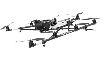
Topcon Positioning Group announces a worldwide distribution partnership with unmanned aerial system (UAS) provider Ascending Technologies. The agreement gives Topcon exclusivity for the global distribution of the AscTecFalcon 8 rotary-wing model, plus the GeoEXPERT and the InspectionPRO sensing and feature packages.
“We are excited to add the brand new Topcon Falcon 8, powered by Ascending Technologies, to our scope of aerial mapping solutions,” said Eduardo Falcon, executive vice president and general manager for the Topcon GeoPositioning Solutions Group. “By distributing both core target models on a worldwide level, Topcon can offer more end-users the flexibility and proven advances that these patented rotary-wing systems provide for survey, inspection and monitoring applications.” The Topcon-branded UAS includes the latest AscTecTrinity autopilot technology.
Based in Germany, Ascending Technologies is a developer and manufacturer of micro UAS for professional, civil and research use. “The AscTecFalcon 8 has been in series production since 2009 and still is the first choice UAS of world market leading inspection and surveying service providers,” said Jan Stumpf, one of the four CEOs and co-founder of Ascending Technologies.
“We are proud that our proven and advanced technology can now be easily accessed throughout the world. With the help of Topcon and its reseller network we can provide our high standards of support and customer service everywhere. This partnership gives us the freedom to continue the development of game changing technologies our customers need, while quickly extending our active fleet of reliable UAVs,” said Stumpf.
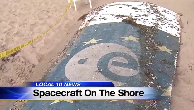
A metal object that may be a large piece of a Galileo rocket has been found on a Florida beach. The object appeared to bear the markings of the European Union’s Galileo satellite program, reports the SunSentinel.
It was discovered Sunday behind the oceanfront Sun Tower Hotel & Suites in Fort Lauderdale.
The mattress-sized fragment attracted onlookers until late Sunday morning when it was tractored off the beach by a city cleanup crew and handed over to police. Police hauled the debris away and planned to hold it for inspection by Federal Aviation Administration officials on Monday, according to police Capt. Frank Sousa.
Several rockets have been launched from the French and European spaceport near Kourou in French Guiana, on the northeast coast of South America. The EU’s Galileo satellite navigation system now has eight satellites in orbit following the launch of the latest pair in March. How the debris ended up on the Fort Lauderdale beach is under investigation.
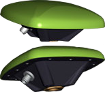
The GrAnt by JAVAD GNSS is a versatile high-performance antenna.
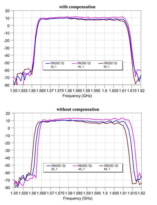
With J-shield — the JAVAD GNSS filter that protects GPS L1, Galileo L1 and GLONASS L1 bands — the GrAnt antenna can track GPS, GLONASS, Galileo, BeiDou, WAAS, EGNOS, MSAS, GAGAN and QZSS signals. J-shield brings in all the useful signals intact and rejects out-of-band signals with the slope of about 12 dB/MHz. Similarly, the filter protects GPS L2, GPS L5, GLONASS L2, GLONASS L3 and Galileo L5, and has slope of about 9 dB/MHz. The filters have been extensively tested with five different innovative tests that prove that the filters also improve the performance of GNSS receivers.
The GrAnt antenna can be mounted on flat surfaces with four screws or mounted on standard poles (5/8-11 or 1-14 inch thread). The antenna cable can be connected via the standard TNC (N-type optional) connector on its side or routed through the center of the antenna for ultimate protection in harsh environments.
An optional ground plane can be purchased to increase multipath mitigation.
The top-level model, the GrAnt-G5T, supports a wider band to accommodate additional signals, with frequencies of 1555-1610 MHz and 1164-1300 MHz. Full signal capability of the GrAnt-G5T is:
Wearable fitness trackers such as FitBit could help military patients recover quicker, according to Col. Deydre Teyhen, an official with from the Defense Health Headquarter’s Office of the Surgeon General. The trackers could help patients with musculoskeletal conditions gauge how much physical activity they can handle without exacerbating their injuries, Teyhen told an audience at a conference hosted by tech association, AFCEA and reported by NextGov.
Device-agnostic software is needed to allow soldiers to use the devices they already own, she said. “The question becomes, is it a one-size-fits-all solution?”
For instance, some patients begin to feel better before their soft tissue heals fully, and start walking around more, which could inhibit their recovery process, she explained. An effective system might send that patient a notification on their fitness tracker to say, “‘You’ve done great, at 1,000 to 2,000 steps a day,’ and it gives you a warning … ‘You might actually be doing too much and you might cause a setback.’ If you give them that warning in real time, then they can change their behaviors.”
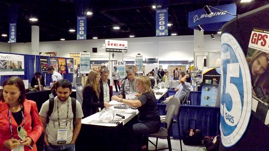
Crowds gather at the GPS World booth at ION GNSS+ 2014.
ION GNSS+ 2015 is the 28th International Technical Meeting of the Institute of Navigation’s Satellite Division and the world’s largest technical meeting and showcase of GNSS technology, products and services and other sensors in today’s marketplace. The conference will be held Sept. 14-18 (tutorials Sept. 14-15) at the Tampa Convention Center in Tampa, Fla.
James L. Green, director of Planetary Science for NASA, will take the audience on a journey navigating through the solar system during his keynote address. He will show new worlds and new discoveries through the eyes of NASA’s planetary spacecraft.
This year’s conference will feature panels of industry experts, policy updates, the world’s largest GNSS commercial exhibit and more than 300 technical presentations presented through both Peer-Reviewed Tracks (Multisensor Navigation and Applications; Algorithms and Methods; and Advanced GNSS Technologies) and Systems and Application Tracks (Mass-Market Applications; High Performance & Safety-Critical Applications; and System Updates, Plans and Policies).
GPS World staff will be moderating the Lightning Talks section of the plenary session, as well as hosting a booth in the Exhibit Hall.
Tap into our up-to-the-minute show coverage here at gpsworld.com and via Twitter (@GPSWorld).
Alan Cameron, GPS World Editor and Publisher, provides the following video introduction to the conference.
Drifting tabular icebergs viewed from the Amundsen. (Photo courtesy of Greg McCullough, University of Manitoba)
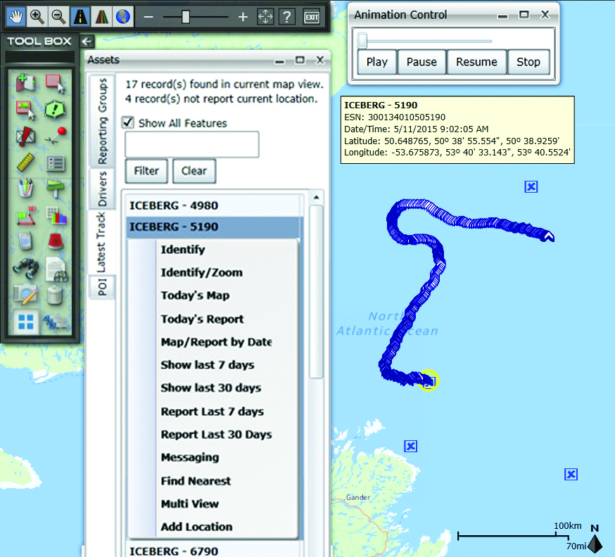
A Canadian expedition team used GeoDecisions’ GeoILS platform to help track icebergs during a voyage to better understand how icebergs drift. An intelligent location server using the Esri ArcGIS platform, GeoILS enables users to monitor and locate assets and facilitate quick and coordinated responses.
GeoDecisions, an information technology company specializing in geospatial solutions, partnered with Solara Remote Data Delivery Incorporated, Canada’s Carleton University and Esri during the project.
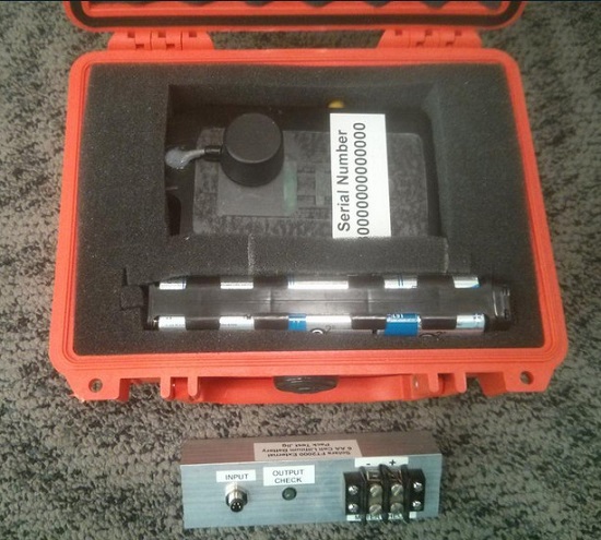
The FT2000IB Solara tracker. (Photo by Tom Tessier)
Led by University of Manitoba Scientist David Barber, the crew of Canadian Coast Guard icebreaker Amundsen sailed off the coast of Newfoundland and Labrador to research ice hazard mitigation, the effects of climate change, and polar region technology requirements. GeoILS location intelligence helped crew members visualize, analyze, and leverage project-pertinent data.
“During the expedition, researchers and scientists used GeoILS to assess drifting through sensor monitors attached to the icebergs,” said Brian Smith, vice president of commercial solutions with GeoDecisions. “In addition to reporting and notifications, GeoILS provided the project team with maps that were tailored by selecting desired iceberg information and the geographic area of interest based on user-defined criteria.”
GeoDecisions’ data portal was used with Iridium Solara tracking devices during the iceberg research project. Two icebergs were outfitted with FT2000IB Solara trackers, explained Derek Mueller, assistant professor and physical geography program supervisor with Carleton University.
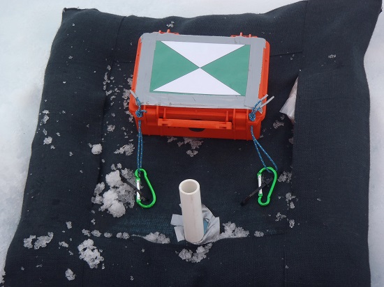
THE GROUND control point and beacon. (Photo by Derek Mueller)
For each iceberg, two beacons were attached for redundancy and to determine the iceberg’s rotation. Holes were drilled and stakes inserted, then GeoDecisions Platform Tracks Icebergs the trackers attached to the stakes.
The trackers were also used as ground control points for photogrammetry, specifically the structure from motion ranging imaging technique.
“GeoILS and the satellite tracking beacons worked very well during this project,” Mueller said. “Thanks to our partners’ efforts, we now have a great new suite of tools for examining our data.”
“We are excited to provide tools to scientists who are gaining critical insights into the behavior of icebergs and global climate change,” said Tom Tessier, president of Solara Remote Data Delivery Incorporated.
The last tracker stopped transmitting on June 13. “The others ended earlier, likely because the iceberg rolled or broke up,” Mueller said.
In a late June filing with the Federal Communications Commission (FCC), Lightsquared asked the agency to reassign its spectrum licenses — which were at the root of a prolonged dispute in 2010 and 2011, and have never been fully utilized — to a new licensee that would be wholly owned by a new company, New LightSquared. This is part of LightSquared’s efforts to re-emerge from bankruptcy.
LightSquared wants to resume its own interference testing scheme, floated in 2011 after an independent, collaborative effort found ample LightSquared interference with GPS. The company has contracted with Roberson and Associates, a technology consulting firm, to develop its interference study.
LightSquared is being represented before the FCC by Reed Hundt, a former FCC chairman who served from 1993 to 1997.
LightSquared listed 28 different GPS receivers and related devices that it wants to test for interference with its terrestrial mobile broadband service. The devices include certified and non-certified aviation receivers and avionics equipment, general location, cell phones and 13 different high-precision clocks and receivers.
Hundt specificaly identifed three companies — Trimble, Garmin, and John Deere — that he wants to come forward and provide proprietary technical and business information “in confidence” to tester Roberson. In statements to the FCC, Hundt twice used the phrase “speak now or forever hold your peace.”
In March of this year, LightSquared obtained U.S. court permission to exit bankruptcy protection, which it entered in 2012. At that time, the FCC had concluded, after lengthy testing, hearings, charges and countercharges, that the wireless broadband service proposed by LightSquared would interfere with GPS signals and associated positioning, navigation, and timing.
New LightSquared reportedly has $1.25 billion in operating funds to help “make full use of its spectrum to provide existing and innovative services.”
In a recent trial involving the assets of the bankrupt company, the value of its spectrum bands was estimated at possibly $4.5 billion or higher.
GPS Industry Response. The GPS Innovation Alliance responded in early July to media reports on LightSquared’s position regarding the testing of the compatibility of terrestrial broadband and GPS.
Following is the GPS Innovation Alliance’s response:
“The GPS Innovation Alliance (GPSIA) supports a consensus-driven process, including all government and non-government stakeholders, to clearly identify and address remaining technical issues raised by LightSquared proposals to repurpose mobile satellite spectrum for terrestrial broadband use.
“The technical challenges posed by these proposals are formidable, as evidenced by the conclusions of multiple U.S. government entities. Specifically, the U.S. Departments of Defense and Transportation and the NTIA have all found in the last several years that LightSquared’s proposals have significant potential to interfere with GPS.
“Contrary to LightSquared’s recent suggestions, this is not simply a private matter between three GPS companies and LightSquared, but is important to all GPS users who rely on this critical technology every day. The Department of Transportation has sponsored an ongoing effort to assess adjacent band issues, and the GPS industry is actively engaged with the Federal Communications Commission (FCC), Department of Transportation (DOT) and other government stakeholders to drive consensus around next steps.
“While we welcome the participation of LightSquared consultants, any further analysis of the technical issues should be informed by input from all of the relevant stakeholders, rather than the one-off efforts of an interested party.”
Tenth GPS Block II Follow-On Satellite Rises Above
This one’s in orbit now. Photo shows the nose cone containing GPS IIF-10 being lowered into position atop the launch vehicle, inside the rocket gantry at Cape Canaveral.
The tenth GPS IIF satellite lifted off from the Space Launch Complex (SLC)-41 at Cape Canaveral, Fla., on schedule at 11:36 local time (15:36 UTC) — at the start of a nineteen-minute window.
Later that same day, United Launch Alliance (ULA) officials declared the launch mission a success. The Centaur upper stage completed its second burn and released the GPS IIF-10 satellite into the navigation network to complete the launch of the Atlas 5 rocket.
This is the second of three GPS constellation replenishment flights planned in 2015. The first launch, of GPS IIF-9 using a Delta IV rocket, occurred on March 25. A third launch, of GPS IIF-11 using an Atlas rocket, is scheduled for Sept. 22. The launch of GPS IIF-12 is scheduled for Jan. 26, 2016.
The Boeing-built GPS IIF-10 is one of the next-generation GPS satellites, incorporating various improvements to provide greater accuracy, increased signals, and enhanced performance for users. GPS IIF-10 was the 70th spacecraft to be launched as part of the GPS constellation and the tenth in the Block IIF series that began launching in May 2010.
GPS IIF-10 marks the 55th Atlas V launch since the vehicle’s inaugural launch in 2002 and the 27th flight of the 401 configuration. Every operational GPS mission has launched on a United Launch Alliance or heritage rocket. While the government has certified ULA competitor SpaceX for GPS III launches, a SpaceX Falcon 9 rocket exploded June 29, two minutes after launch of an International Space Station resupply mission.
The Boeing-built GPS IIF satellites provide improved signals to support both the warfighter and the growing civilian needs of the global economy, the U.S. Air Force said in a statement. The GPS IIF satellites will provide improved accuracy through advanced atomic clocks, a longer design life than previous GPS satellites, and a new operational third civil signal (L5) that benefits commercial aviation and safety-of-life applications. It will also continue to deploy the modernized capabilities that began with the GPS IIR satellites, including a more robust military signal.
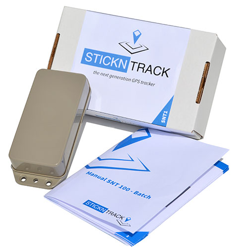
StickNTrack — an award-winning low-power tracker from Sensolus — is now active in eight European countries.
StickNTrack guards and tracks position, journeys, motion and status of any non-powered asset without the hassle of charging batteries, managing SIM cards or an intrusive installation, Sensolus said.
StickNTrack’s web-based service platform is tailored for low-power asset tracking communicating over the French-based Sigfox. Because Sigfox is an ultra low-power communication network, it significantly reduces StickNTrack’s power needs so that it consumes up to 40 times less power and lowers life-cycle costs by 50 percent compared to existing compact GPRS/GPS products, Sensolus said.
The tracker’s power can last up to five years. In the third quarter, an upgraded version will be released with extended battery lifetime up to nine years, according to Kristoff Van Rattinghe, who developed StickNTrack along with Laurence Claeys, Johan Criel and Koen Van Vlaenderen.
Users can access the StickNTrack web portal with any smartphone running Android OS or iOS. The full feature set can be accessed on a tablet or laptop. Features include interactive timelines, intuitive geofencing, email alerting and optimized energy savings.
The ruggedized, waterproof StickNTrack is 120 x 50 x 25 millimeters and weighs 255 grams. It can track assets on the water, such as yachts or buoys, providing automated logbooks, alerting users when assets enter or exit specific zones (such as harbors), and providing real-time journey information for those at home.
StickNTrack’s developers took third place in the 2014 European Satellite Navigation Competition, after taking first in the Flanders regional competition. It also won the European Space Agency’s Innovation Award.
Dubbed a “distruptive innovation” by the European Satellite Navigation Competition (ESNC), StickNTrack “opens up an abundance of new business opportunities in tracking trailers, containers, machinery, tools, bikes and more. Future accuracy and availability improvements based on GNSS will trigger additional advancements, such as by automating supply chains for packages and their delivery. Ultimately, stickNtrack is a next-generation location tracker that significantly lowers the barriers to embedding even more GNSS technology into our daily lives.”
“Every day new types of non-powered assets are being connected to our service platform,” Van Rattinghe said. In the coming years, Sigfox aims to provide global coverage.