Earlier this year, a drone pilot and two data scientists from PrecisionHawk traveled to the Philippines for a unique mission — to fly drones equipped with lidar sensors over a dense rainforest to map ancient trade paths. The aim was to find buried treasure left by the Japanese during World War II.
PrecisionHawk was approached by the producers of a new History Channel show to help them navigate the Filipino rainforests. Through the combination of air and ground sensors, including a DJI M600 UAV equipped with a Riegl miniVUX lidar sensor and a Sony a6000 camera, PrecisionHawk staff produced a colorized 3D map of the forest.
The History Channel aired the series premiere of “Lost Gold of World War II” on March 19, 2019; all eight episodes are now available for streaming. The second episode features visuals generated by PrecisionHawk, as well as interviews with the drone pilot and data scientists.
Course takes learners on a deep dive into concepts and applications
Esri logo
Esri will offer a new massive open online course (MOOC) on spatial data science early this year. The no-cost course, which will run for six weeks on Esri’s Training website, includes full access to ArcGIS Pro, ArcGIS Online and ArcGIS Notebooks software.
Spatial Data Science: The New Frontier in Analytics opens on Feb. 26 and provides a comprehensive introduction to how incorporating location enhances traditional data science workflows.
“Spatial data science builds on foundational data science techniques and adds the spatial perspective that really makes a huge difference in the outcomes of an analysis,” said Lauren Bennett, software development lead on Esri’s spatial analysis and data science team.
The course includes video presentations by Esri experts, discussion forums, and hands-on software exercises. Participants will discover how including spatial data and spatial analysis tools and techniques can dramatically improve predictive modeling, uncover previously hidden patterns, and solve problems.
“At its core, spatial data science is about solving problems,” Bennett continued, “using spatial algorithms, taking the latest and greatest techniques (statistics, machine learning, deep learning) and all the tried and true, more traditional techniques to turn data into information.”
Each section of the course will focus on a specific topic and application of spatial data science. From data engineering and visualization to suitability modeling, pattern detection, space-time pattern mining, and object detection with deep learning, participants will explore a wide range of scenarios using realistic data and powerful ArcGIS tools.
While many practitioners emphasize craft when sharing results, course authors champion the notion that successful analysts and data scientists must be able to effectively communicate the impact of their work with leaders and colleagues. For this reason, the final section of the course will explore the use of ArcGIS StoryMaps to craft visually appealing and information-rich narratives that resonate.
Spatial Data Science: The New Frontier in Analytics is open to learners worldwide. All that’s needed to attend is an Esri account, which is free and easy to create at accounts.esri.com.
Participants with a background in statistics, data science and Python are encouraged to attend, but anyone interested in exploring technology hot topics and learning the latest analytical capabilities of ArcGIS software will benefit as well. A certificate of completion will be awarded to all participants who finish the course.
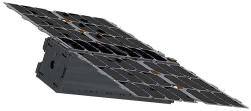
Swiss start-up Astrocast launched successfully its first test satellite from Vandenberg Air Force Base, 4 December 2018. (Photo: ESA)
CubeSats are nanosatellites based on standardised 10 cm-sized units. Originally devised for educational uses, they are nowadays being put to commercial and technology testing uses. The Swiss Astrocast company is assembling a constellation based on 3-unit CubeSats to serve the emerging internet of things (IoT).
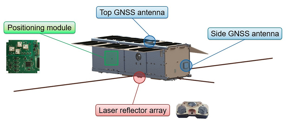
Vigilant for new initiatives that foster innovation in the field of navigation, ESA navigation researchers supported Switzerland’s ETH Zurich technical university to fly a navigation payload — composed of four low-cost multi-constellation mass-market satnav receiver modules plus two antennas — aboard a test CubeSat.
“This mission has demonstrated the first use of Galileo to perform positioning and timing in orbit supporting precise orbit determination using a commercial product developed for ground users,” explains ESA’s Global Navigation Satellite Systems (GNSS) R&D Principal Engineer Roberto Prieto Cerdeira.
“The purpose of this initiative was to demonstrate the capabilities of Galileo in orbit with a small, low-cost, low-power European satnav receiver. This will pave the way for future navigation experimentation, scientific experiments and technology demonstrations of Galileo in orbit with CubeSats and low-cost receivers for scientific activities.
This Astrocast CubeSat launched in December 2018 included a test satnav receiver. (Image: ESA)
“The navigation payload is also capable of performing position fixes by combining Galileo with the US GPS, Russian Glonass and Chinese BeiDou systems for increased performance.”
ESA R&D navigation engineer Rok Dittrich adds, “The receiver itself was not specially developed and tested for space but is a modified version of a low-cost mass-market product from the Swiss u-blox company. It underwent ground testing emulating its use in space, along with firmware added to take into account the dynamics of low-Earth orbit.”
This opportunity, funded through ESA’s European GNSS Evolution programme, was conceived together with ESA’s Galileo Science Advisory Committee, a group of scientists advising ESA on scientific matters related to Galileo and fostering its scientific exploitation.
This first AstroCast CubeSat was launched in December 2018, and the first results confirming the use of Galileo satellites for positioning were reported at the recent Galileo Science Colloquium in Zurich, typically demonstrating orbital positioning precision down to less than 5 m.
ESA’s Galileo Navigation Science Office and GNSS Evolution are looking into extending this pioneering experience to perform more CubeSat-based experiments in space to test ideas for evolutions of European satnav systems and scientific experiments with Galileo, in partnership with universities and research institutions.
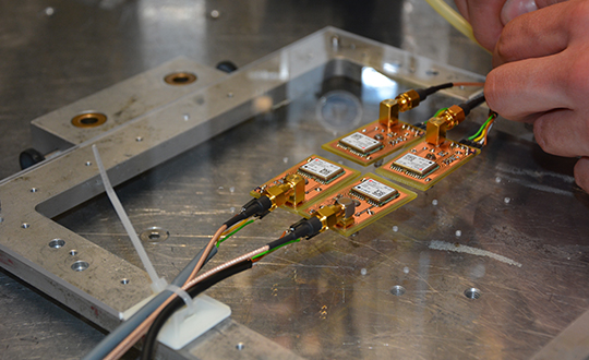
The Astrocast CubeSat’s four u-blox receiver modules mounted on an acrylic glass to be placed into a proton radiation beam at the Paul Scherrer Institute in Switzerland. (Photo: ESA)
Satnav is already widely used by satellites in low-Earth orbit for guidance, navigation and control, relying on the satnav constellations flying above them in medium-Earth orbit. Some telecommunication and weather satellites in higher orbit also make use of the satnav signals flying at lower orbit, with very weak satnav signals from satellites located at the other side of the Earth.
For the future, satnav is a key enabling technology for the safe operation of low-Earth orbit constellations, allowing individual satellites to maintain optimum formation relative to the other constellation members.
ESA and NASA have previously demonstrated Galileo-only and Galileo-GPS fixes from the International Space Station, although using a space-qualified software-based receiver.
ESA is developing dual Galileo-GPS receivers for the next generation of Earth-observing Copernicus Sentinel satellites. The more precise the orbit determination, the more accurate the environmental data that can be returned to Earth.
Combined use of Galileo and GPS signals on an interoperable basis for positioning and precise orbit determination should bring significant advantages for space users in particular, set to provide a seamless navigation capability from low to high Earth orbits — and potentially beyond.
The Astrocast CubeSat’s navigation payload comprises four global navigation satellite system (GNSS) receiver modules plus two antennas. (Diagram: ESA)
Thales Alenia Space has been awarded a grant under the European GNSS Agency’s (GSA) Fundamental Elements funding mechanism for the development of the GIANO (Galileo-based TIming Receiver for CriticAl INfrastructure Robustness) receiver, which aims to make critical infrastructure more robust against interference, jamming and spoofing.
In an increasingly complex GNSS environment in which there is both unintentional and deliberate disruption of satellite signals, the GSA is funding the development of a timing receiver for professional applications to address the needs of the critical infrastructure user community, mainly energy generation and distribution, telecommunications and financial operators.
Improved resilience
The GIANO receiver will leverage Galileo and EGNOS-driven innovation to improve the resilience of the receiver against interference, jamming and spoofing and increase the accuracy and reliability of the time transfer service. The timing platform prototype to be developed and validated will integrate all the latest innovative technologies, including professional products from Thales Alenia Space, paving the way for future Galileo-based timing receivers that offer improved resilience and accuracy at a reasonable cost.
“Critical infrastructure operators use GNSS for timing and synchronisation and are an important target segment for GSA Market Development because Galileo can make a difference. By funding the development of the GIANO receiver, the GSA aims to provide technological solutions to this community for robust and reliable timing,” said GSA head of market development Fiammetta Diani.
Toward this goal, outreach activities have been conducted among potential final users in the main commercial target groups to collect and analyse their needs. Then, following the definition and consolidation of stakeholders’ needs and the platform specifications, the project conducted a preliminary design review at the end of November 2019.
Europe-wide cooperation
The two-year project, funded under a GSA grant related to the Development of a Galileo-based timing receiver for critical infrastructures (GSA/GRANT/05/2017), will be coordinated by Thales Alenia Space in Italy, in collaboration with four European partners: Business Integration Partners S.p.A (BIP, Italy), PIKTime Systems (Poland), Space Research Centre of the Polish Academy of Science (SRC PAS, Poland) and DEIMOS (Portugal).
The project will also benefit from the support of the European Commission’s in-house science service – the Joint Research Centre (JRC) and the Italian National Metrology Institute (INRIM), which will make available its test facilities for verification activities on the developed equipment.
A version of the NeQuick G algorithm using a new coding approach is now available for download on the GSC website. This version is the result of intensive recoding by engineers at the EU’s Joint Research Centre.
GNSS signals traveling through the ionosphere can be significantly delayed by the electrical charges in this atmospheric layer before reaching the users’ terminal. To compensate for this delay in the signal, Galileo receivers integrate a dynamic model of the ionosphere composition known as the NeQuick G model.
Receiver manufacturers will now be able to benefit from a version of the NeQuick G correction algorithm that implements a new coding approach.
Rigorous testing
The JRC concluded its work recently after successful rigorous testing in the framework of the gLAB tool (GNSS software suite from the Universitat Politecnica de Catalunya). This version of the code has been designed to be highly modular, rendering it more legible for a potential programmer with no specific knowledge about signal propagation in the ionosphere. A library has been also developed to enable its quick integration into existing applications.
This software will be released as free and open source software under the terms of the European Union Public Licence (EUPL), version 1.2.
The open-source code is now ready to be implemented on single-frequency platforms and can be used on a global scale without limitation under the EUPL. This freedom should contribute to a wider adoption of the NeQuick G model at user level.
Hexagon AB has introduced HxDR, a new cloud-based, digital reality visualization platform, at CES 2020.
HxDR creates accurate digital representations of the real world through the seamless combination of reality capture data from airborne, ground and mobile sensors. Users can then leverage the complete, accurate and precise replicas to visualise and share their 3D design projects and models within a real-world context.
CES 2020, the massive annual consumer electronics show, is taking place Jan. 7-10 in Las Vegas. HxDR will be demonstrated at CES 2020, in Hexagon’s pavilion CP-15.
Airborne imagery and laser scans, indoor and outdoor terrestrial scan data and mobile mapping data can be seamlessly combined using HxDR. Users can drag and drop their reality capture files into HxDR and the automated meshing function does the rest. Or, they can license real-world replicas from Hexagon’s 3.6-petabyte collection of towns, cities and landscapes.
HxDR is specifically designed to help a myriad of professionals make more informed decisions. For instance, architects can share 3D building designs with project stakeholders within accurate digital replicas of real-world locations.
Media and entertainment professionals can remotely scout production locations as well as leverage HxDR to streamline production workflows. City officials can leverage HxDR in their smart city platforms for urban planning and development.
“HxDR enables customers to create their own Smart Digital Realities, addressing the growing need for simple-to-create yet highly sophisticated and accurate visualizations of reality capture data that boost project efficiencies and cost savings,” said Hexagon President and CEO Ola Rollén.
“We’re uniquely positioned to deliver this innovative platform due to the vast library of data captured from our world-leading sensor and visualisation services portfolio — a portfolio we continually enhance through R&D and strategic acquisitions such as Technodigit, Luciad, MyVR, and the newly-acquired Melown Technologies,” Rollén siad. “Moving forward, we anticipate HxDR will play a critical role in the formation of smart city and smart nation platforms that will increasingly reflect the needs of citizens today and in the future.”
In 2019, military forces witnessed the global threat of GPS/GNSS interference grow, with more sophisticated threats and increasing military demand for assured operations in Navigation Warfare (NAVWAR) and GPS-denied environments.
Enemy forces are deploying more advanced jamming and spoofing technologies worldwide, jeopardizing the security and reliability of positioning, navigation and timing (PNT) data that feeds into GPS receivers, downstream networks and subsystems.
Military forces must vigilantly protect their information advantage from malicious attacks by delivering situational awareness, mission planning and warfighter solutions.
For these priorities, proven and efficient signal integrity solutions will be even more critical in 2020.
Requirements to Ensure Signal Integrity in 2020
Any critical system that relies on PNT data should go into the field with two known states:
First, it should withstand a GPS outage during testing and simulation — including rigorous jamming and spoofing simulation to predict how the system will react under various conditions. Simulation scenarios can vary in complexity, and newer software-defined simulators provide flexibility to meet current requirements while future-proofing investments in test equipment.
Second, the system should have a signal threat detection and alert mechanism. Critical systems also need backup layers such as anti-jam antennas, threat mitigation technology and alternative encrypted signals to ensure continuous operations, even in compromised environments.
Going into 2020, GNSS simulation and interference detection and mitigation (IDM) will continue to adapt to emerging threats and provide the essential foundation for Assured PNT.
For more about Resilient PNT and NAVWAR solutions, visit www.Orolia.com.
uAvionix has received U.S. Federal Aviation Administration (FAA) approval for the Vehicle Tracking Unit (VTU-20) Automatic Dependent Surveillance – Broadcast (ADS-B) transmitter for airport surface management.
uAvionix is a designer and manufacturer of communications, navigation and surveillance (CNS) equipment for unmanned and manned aircraft.
Adhering to the performance and design assurance specifications of FAA-E-3032, the externally mounted VTU-20 ensures integration and interoperability with Airport Surface Detection Equipment, Model X (ASDE-X), Airport Surface Surveillance Capability (ASSC) and ADS-B receiver surveillance solutions for airport
surface control and situational awareness.
The VTU-20 can be permanently or magnetically mounted to all airside vehicles, including utility, emergency, snow-removal and maintenance equipment. Each vehicle is clearly and uniquely identified, providing an essential addition to any surface movement guidance and control system.
The VTU-20 implements FAA-approved Squitter Transmission Maps to automatically enable transmission on airport movement areas and disable transmission in low-risk areas or outside airport airside operations.
“Ground vehicle incursions into critical safety and movement areas is on the rise. With this achievement, uAvionix continues to promote safety and common situational awareness not only in the airspace but also on the airport surface,” states Christian Ramsey, uAvionix president.
This recent uAvionix achievement will be made available through an exclusive relationship with L3Harris Technologies, Inc., a leader in surveillance and air traffic management known for the Symphony product line of airport operations and environmental compliance solutions — to promote and sell the VTU-20 in the United States.
What is or would be the best policy response from Congress and/or executive branch agencies to the growing threats to GPS from jamming and interference?
Brad Parkinson
“Homeland Security has declared GPS to be an essential system to virtually all of our infrastructure. It is time to install a national system to identify and shut down interference. As part of that, all cell phones should periodically report interference to that national system and allow law enforcement to pinpoint and eliminate offenders.”
-Bradford W. Parkinson
Stanford Center for Position, Navigation and Time
Allison Brown
“On Dec. 5, 2018, the president signed into law the National GPS Timing Resilience and Security Act tasking the Secretary of Transportation with establishing a backup timing system for GPS within two years. To date, only limited technology demonstrations have been performed. Congress needs to fund the Department of Transportation to rapidly acquire and deploy a back-up timing capability, using available commercial solutions, to assure resilience within the Air Traffic Control system and other critical infrastructure to GPS jamming or spoofing.”
-Alison Brown
NAVSYS Corporation
Members of the EAB
Tony Agresta Nearmap
Miguel Amor Hexagon Positioning Intelligence
Thibault Bonnevie SBG Systems
Alison Brown NAVSYS Corporation
Ismael Colomina GeoNumerics
Clem Driscoll C.J. Driscoll & Associates
John Fischer Orolia
Ellen Hall Spirent Federal Systems
Jules McNeff Overlook Systems Technologies, Inc.
Terry Moore University of Nottingham
Bradford W. Parkinson Stanford Center for Position, Navigation and Time
GIS data collection application GIS Surveyor now includes the ED-50 zone, reports maker Polosoft Technologies. ED-50 is a geodetic datum. The ED-50 zone includes a different datum shift for the Universal Transverse Mercator grid. Germany, Netherlands and Belgium lie in the ED-50 zone.
The ED-50 UTM zone is a coordinate reference system (CRS) for large- and medium-scale for topographic mapping and engineering surveys. Different types of surveys are performed in this area, including hydrographic, land, boundary and tunnel surveys. Surveys performed in these areas are advanced and require high-end features that fulfill the purpose of the survey.
A geodetic coordinate system sets reference points used to locate places on Earth. The approximate definition of sea level is the datum WGS84. All other datums are defined for other areas or at other times. Moving westward across Europe, the longitude lines on ED50 gradually become further west and are around 100 meters west in Spain and Portugal.
The longitude and latitude lines on the two datums remain the same in the Archangel region of north-west Russia. Moving southwards, ED-50’s latitude lines gradually become further south than the WGS 84 lines and are around 100 m south in the Mediterranean Sea.
Only a few survey applications support the ED-50 UTM zone coverage. Surveyors around the world used GIS Surveyor while it was in the beta stage. Now that the application has released its full version, which comes with a subscription with additional advanced features, the Polosoft team is hoping that users will continue to support the application. GIS Surveyor also supports lambert 93 zone (France), where there’s a high scope for large- and medium-scale topographic mapping and engineering surveys.
In the context of geographic data, the ultimate standard of quality is the degree to which a data set is fit for use in a particular land survey application.Polosoft Technologies said GIS Surveyor provides users with accurate data.
Topcon Positioning Group released a new strategy through its Topcon Solutions Store retail channel. Together with Autodesk, and as an Autodesk Platinum Tier Partner, the Topcon Solutions Stores retail channel plans to expand top-tier service to civil-construction and BIM professionals through acquiring and adopting automation into its workflows.
The plan calls for a shift from traditional retail “box moving” sales approach, to a complete solution offering that combines hardware, software, and services. In order to deliver best-in-class service, training, and support, the plan includes renovation for 11 Topcon Solutions Store facilities in preparation to obtain their Autodesk Authorized Training Center (ATC) designation — joining two more store locations that are already approved Autodesk Training Centers.
The Autodesk Platinum Tier partner designation indicates the highest level of reseller status, and will allow TSS to continue to grow with significant investment in training, consulting and development services.
Mark Contino, Topcon VP, North American Retail Distribution, said, “By combining Topcon’s precision measuring and positioning hardware with Autodesk’s world-class software portfolio, the Topcon Solutions Stores seamlessly provide complete end-to-end workflows that greatly improve productivity and efficiency. Soon, all 13 locations across the U.S. will be repositioned to deliver the highest level of training, support, and workflow consulting services in the civil construction and BIM space. Not only will Topcon Solutions Stores be able to help customers analyze operations, every location will also help all the way through implementation and on-going support with local, professional training programs.
“The renovation of our facilities across the U.S. is part of our dedication to offer the modern solutions centers that the industry demands to provide this service,” Contino said.
Kirk C. Givens, senior manager, Autodesk Americas Channel Sales, said, “Topcon’s strategy to deliver a complete end-to-end solution in the civil-construction and BIM space is exciting. It’s truly game changing to be able to deliver a complete workflow combining two world class solutions – Autodesk software and Topcon hardware. Supporting that through 13 brick-and-mortar locations with professional training and support facilities will provide tremendous value to customers in the construction market.”
Four trail-blazing industry leaders that have used cutting-edge technology to address some of humanity’s biggest challenges have been recognized at the inaugural GIS Hall of Fame awards in Brisbane.
From providing critical data to aide frontline response to the devastating bushfires burning across Queensland, to underpinning a global project to map the ocean’s floor — the 2019 award winners have innovatively used Geographic Information System (GIS) technology to make a real difference to the community and grow Australia’s multi-billion dollar geospatial industry.
Geoscience Australia and Queensland’s Department of Natural Resources, Mining, and Energy (DNRME) were presented with GIS Pioneer Awards for their extraordinary leadership in both the application and advancement of the science of GIS.
Lifetime Achievement in GIS Awards were presented to Martin Rutherford, the Department of Defence’s Director of Maritime Geospatial Intelligence; and Gary Maguire, director of StateStat at the South Australian Government – for their unparalleled commitment to industry innovation.
Esri Australia and Esri South Asia Group Managing Director Brett Bundock said the award recipients are true global ambassadors for Australia’s $2.1B GIS industry.
“Thousands around the country use GIS technology on a daily basis – however today’s award recipients have an unmatched record of contributing to the advancement of science, demonstrating creative thinking, inspiring leadership and most importantly community mindedness,” Bundock said.
“Geoscience Australia’s ground-breaking work in the search for missing Malaysian Airlines flight MH370 has seen them take a pioneering role in the Seabed2030 project, which aims to map the world’s entire ocean floor in high resolution by 2030.
“DNRME have set the benchmark for creating world-leading open data platforms that break down traditional barriers for government agencies, commercial organizations and the community to have self-serve access to meaningful public data.”
DNRME Executive Director of Land and Spatial Information Steven Jacoby said the Queensland Government widely uses GIS technology across almost every facet of their operations.
“The department has striven for the last 30 years to be at the forefront of the use of GIS technologies, to improve decision making not only within government and private organizations but also to empower the public,” Jacoby said.
“Across QldGlobe, QSpatial and QImagery, this team provides around 500 services a second, catering to anything from an address check, to searching for an image or just checking on the globe – and we’re only getting busier.
“In 2018, this team provided over 450 million services and by the close of 2019, we will have surpassed 600 million.
“The growth and the success of the department in this area can only be put down to the incredible work of countless individuals over the past 3 decades, helping us to grow, shape and develop a culture that gets the right information to people, when and where they need it.
“We recognise this is an ongoing challenge and the public’s expectations will only grow. I am very confident that the DNRME team will continue to meet the high standards acknowledged by this Award and we look forward to working further with Esri Australia to improve the delivery of Queensland’s critical spatial information.”
The official Awards Ceremony for the inaugural Australian GIS Hall of Fame was held on Nov. 20 at Brisbane Convention and Exhibition Centre.