Hexagon AB, which offers sensor, software and autonomous solutions, has signed an agreement to acquire Volume Graphics, a specialist in industrial computed tomography (CT) software.
Volume Graphics brings more than 20 years of experience in non-destructive inspection and testing software development. The company’s high-end analysis and visualization CT software enables manufacturers to produce three-dimensional external and internal representations of scanned objects.
Using CT, they’re able to “see” inside the complicated structures of components, otherwise inaccessible with traditional inspection methods. This allows hidden or hard to reach internal features to be measured and inspected for dimensional deviations and flaws without destroying the parts and compromising the integrity of the data in the process.
“Volume Graphics offers an invaluable toolset for leveraging CT data across many use cases — from flaw detection and failure analysis to reverse engineering applications,” said Hexagon President and CEO Ola Rollén. “We look forward to merging our capabilities so that customers can ensure the highest product quality throughout product development and production. Additionally, industrial CT scanning is fast becoming a critical asset to manufacturers as more and more industries embrace additive manufacturing. The addition of CT software capabilities strengthens our portfolio in this growth area.”
Today, a broad range of global customers from the automotive, aerospace and electronics industries use Volume Graphics software for quality assurance.
Founded in 1997 and headquartered in Heidelberg, Germany, Volume Graphics employs around 160 people worldwide. Subsidiaries in Japan, Singapore, China and the U.S., supplemented by an extensive reseller network, deliver its software to customers in more than 50 countries.
Volume Graphics will operate as part of Hexagon’s Manufacturing Intelligence division. Completion of the transaction (closing) is subject to regulatory approvals. 2018 sales amounted to 25 MEUR.
The funding enables continuation of a national effort by state government geospatial information officers and coordinators to work with other state agencies, local elections officials and state elections offices, national GIS (geographic information system) and elections organizations, and federal partners to identify opportunities to leverage this powerful technology to strengthen elections management and citizen engagement.
“As an organization made up of GIS leaders in state government, NSGIC is uniquely positioned to leverage the innovative work of states to use GIS for elections data,” said Molly Schar, NSGIC executive director. “We have enlisted those innovators to contribute and advise throughout the project. Collaboration has been key to the success of the project. Relationships built in the first phase of the project will be invaluable to the work of the second phase as the project seeks to increase engagement and, ultimately, impact.”
Two more years. The Geo-Enabled Elections project was launched in October 2017 and will now continue for an additional two years. The project aims to help strengthen electoral systems by supporting states in the adoption of GIS.
In practical terms, this means encouraging state governments to replace non-spatial address-file systems with election precinct and voter data in a GIS format, leveraging that format’s inherent visual and analytical advantages.
With its second phase, the project turns to focus on working hands-on with up to 10 more states through the pilot program, developing a curriculum for elections officials on foundations of GIS in elections, increasing awareness of the benefits of geo-enabling elections systems among elections stakeholders, and developing policy guidance and advocacy tools to support integration of GIS in elections.
“Accurate boundary lines and efficient voter placement are the building blocks of our elections and are tantamount to the integrity of the democratic process,” said Tammy Patrick, senior advisor at Democracy Fund Voice. “Democracy Fund Voice is a proud sponsor of efforts such as NSGIC Geo-Enabled Elections as a way to further ensure that the American electorate is well served.”
A report of the work done in the first phase of the project is now available.
Accomplishments in the first two years include:
developing an inventory of state implementations of GIS-based elections systems
giving workshops and presentations at national conferences
publishing detailed reports sharing the state of GIS in elections from the perspective of election officials and state GIS leaders
five pilot and case studies
development of a best-practices guide (both in detail and brief versions) was developed
Also, an inaugural Elections GeoSummit in August convened stakeholders from the national, state, and local levels to discuss best practices for geo-enabling elections in the United States.
These documents and other important resources can be found in a PDF format on the NSGIC website.
Pointfuse has developed smart software that automates the identification and classification of objects for facilities management applications using data from mobile mapping systems like the new Leica BLK2GO.
Pointfuse software converts the millions of individual measurements captured by laser scanning and photogrammetry into useable 3D mesh models. The unique ability to classify objects within Pointfuse, both automatically and manually, has already had a huge impact on how as-built data is used within design and construction. It can now realize real time records for space utilization and optimization projects, reducing costs and speeding workflows within facilities management.
The Leica BLK2GO. (Photo: Leica Geosystems)
Pointfuse Simple BIM (sBIM) leverages the core functionality of Pointfuse — the segmented mesh model; automatically converting classified mesh models into “family” groups, such as walls, floors, doors, windows, etc. for use with popular downstream BIM and FM software. Pointfuse sBIM data can then be exported as IFC (Industry Foundation Class) parametrized objects and 2D floors plans and space management reports easily derived. Pointfuse sBIM also automatically calculates quantities, areas and dimensions in an easy to read PDF report.
“This ability to convert classified objects into family place holders has a huge impact on how as-built data is used within a Scan2BIM workflow with the potential for a real return on investment for facilities and space management applications,” said Mark Senior, regional sales director at Pointfuse. “The combination of ease and speed of data capture, as offered by modern hand-held indoor mapping systems like the newly launched Leica BLK2GO, with the automation of Pointfuse processing will release the potential of laser scanning across this sector.”
Pointfuse sBIM was developed in response to a large scale client opportunity that saw the scanning of millions of square feet of facilities with the final deployment of data in Archibus facilities management software using Autodesk Revit as a bridge. Early testing identified that 3D was as quick to create as traditional 2D workflows and exported data is in the region of hundreds of Kbs compared to the Gb volumes of the original point cloud. Taking the process one step further Pointfuse provides an accurate record of the as-built scene by allowing users to create Hybrid meshes combining Pointfuse models with the sBIM IFC container.
Pointfuse will be showcasing the sBIM functionality at the Autodesk University (AU) Expo which takes place Nov. 19-21 at the Sand Expo Convention Centre in Las Vegas, Nevada.
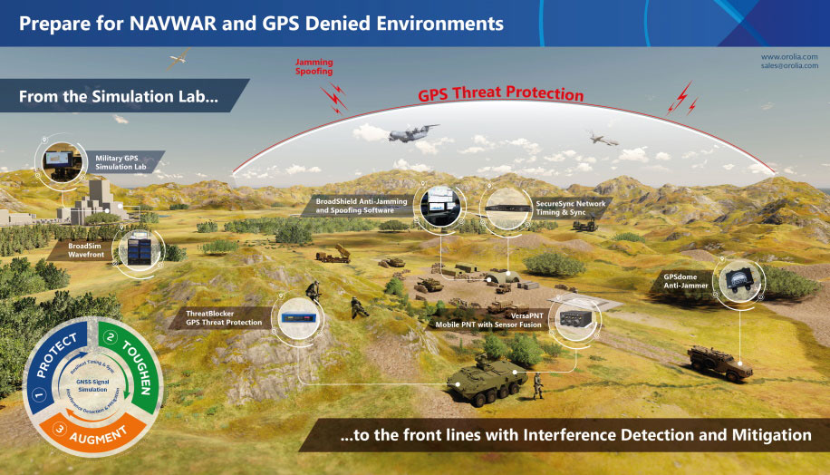
Resilient positioning, navigation and timing (PNT) company Orolia has nearly tripled new U.S. military orders for specialized resilient PNT solutions in the third quarter of 2019, the company stated in a press release.
Orolia said its solutions are helping to meet growing military demand for assured operations in Navigation Warfare (NAVWAR) and GPS-denied environments.
In the third quarter, Orolia unveiled its new Simulation and Interference, Detection & Mitigation (IDM) suite, announced the acquisition of GNSS simulation company Talen-X and introduced new advanced GNSS jamming and spoofing countermeasures.
The new U.S. military orders include the full range of Orolia’s resilient PNT solutions.
“This rapid industry response affirms Orolia’s commitment to delivering trusted military solutions for GPS denied environments,” said Paul Zweers, Orolia vice president of sales and marketing.
Letter signed to advance role of geospatial knowledge infrastructure in global society and economy
Geospatial Media & Communications has signed a letter of cooperation with the United Nations Statistics Division (UNSD) to work together to advance the role of geospatial knowledge infrastructure in global society and economy.
Consistent with their respective mandates, the UNSD and Geospatial Media will collaborate to carry out activities related to their common objective of demonstrating the value of global geospatial knowledge, the data ecosystem, public-private partnerships, and their contribution towards building Geospatial Knowledge Infrastructure and the Global Development Agendas.
The agreement was signed by Stefan Schweinfest, director, UNSD, Department of Economic and Social Affairs, and Sanjay Kumar, CEO, Geospatial Media, in New York on Oct. 31.
“The United Nations 2030 Sustainable Development Agenda is ambitious and requires countries to have solid national information systems to successfully stir the process of implementation. It is a central task of my office, the United Nations Statistics Division, to support countries in building the necessary national information capacities, both in the area of statistics and geospatial information. For this challenging task we need the cooperation of the private sector through well established public-private partnerships. Geospatial Media & Communications is a unique partner in this respect, due to its global reach and its in-depth knowledge and understanding of country needs. I am, therefore, delighted to cooperate with them closely in the coming years,” said Mr. Schweinfest.
“Pursuing its vision to make a difference through geospatial knowledge in world economy nad society, Geospatial Media has been evangelizing geospatial industry globally for over two decades through research, advocacy, media and knowledge exchange platforms. It has contributed in the formation and strengthening of several institutions, including the Association of Geospatial Industries (AGI), World Geospatial Industry Council (WGIC), UNGGIM Private Sector Network and the National Think Tank on Geospatial Strategy for New India. Through this collaboration, our intent is to further our vision to showcase high level value of geospatial knowledge in global development agenda and facilitate alignment and evolution of geospatial stakeholders with emerging socio-economic development models in the fourth Industrial age,” said Mr. Sanjay Kumar.
The intended collaboration will focus on a number of common objectives at national, regional and global levels which will include:
Working together to create joint programs and projects to develop geospatial knowledge infrastructure, networks and human resource capacities;
Assessment of the prospective role of geospatial knowledge infrastructure in global society and economy;
Collaboratively developing broader methods, guidelines, architectures and policy frameworks for the adoption, utilisation and benefits of geospatial knowledge infrastructure;
Develop documents, training modules and other resources to assist National Geospatial Information Agencies in their transformation and modernization aspirations in alignment with the national to global vision of the Integrated Geospatial Information Framework;
Facilitate a collaborative knowledge exchange and engagement atmosphere between the commercial geospatial industry, national geospatial agencies, and the broader user industries and civil society, towards developing public-private partnership models for co-creating geospatial knowledge infrastructure and strengthening of industry and institutional capacities; and
Advocate, communicate and promote the value and utility of geospatial information and enabling technologies for sustainable development.
Touch GIS has released the Touch GIS app for iPhone and iPad. Users can explore the app’s features with a free 14-day trial.
Touch GIS offers professional-grade field data collection and visualization. It takes advantage of devices already used by many people, making field data collection easy and convenient, the company said.
Features include:
an intuitive interface
offline capabilities
map caching
robust file support
customizable attribute forms
preloaded feature class templates
Users can collect point, line and polygon features, as well as create custom feature classes.
File types supported include Shapefile, KML/KMZ, GeoJSON, GPX and CSV (Export).
Custom Forms:
– Description
– Date & Time
– Photo
– List Of Values
– Checkbox
– Address
– Number
– Website
– Phone Number
Preloaded Feature Classes:
– Forestry
– Geology
– Real Estate
– Stream Surveys
– Water Infrastructure
– Wetlands
– Create Your Own!
Adva has launched a modular multi-band GNSS receiver for ePRTC and PRTC-B synchronization, bringing increased precision timing to 5G networks.
The new solution is engineered to overcome ionospheric delay variation that causes timing inaccuracy, enabling communication service providers (CSPs) and enterprises to deliver nanosecond precision.
Previously, this was achieved with expensive, rubidium clocks.
Installed synchronization infrastructure can be installed to increase accuracy and reliability. The multi-band, multi-constellation GNSS receiver card plugs into Adva’s OSA 5430 and OSA 5440, advanced core grandmaster clocks able to support PTP, NTP and SyncE over multiple 1Gbit/s and 10Gbit/s Ethernet interfaces.
This enables network operators to meet the requirements of the ITU’s stringent PRTC-B specifications and support advanced 5G applications.
“What we’re offering the market is an entirely new route to high-precision UTC-traceable network timing that doesn’t require significant investment. Our future-proof technology gives businesses and CSPs a way to boost synchronization performance and meet the ITU’s tight PRTC-B specifications without resorting to expensive alternatives.”
Photo: Adva
“Our new multi-band GNSS receiver is a major milestone for network synchronization. For the first time, operators can harness a solution with multi-band GNSS capabilities combined with our core devices, which can deliver line rates up to 10Gbit/s and support ePRTC levels of timing accuracy,” said Gil Biran, general manager, Oscilloquartz.
“Our modular technology offers a way to enhance equipment in the field, achieve PRTC-B levels of timing and improve the timing accuracy of ePRTC. All that’s required is a simple antenna upgrade. Then our multi-band solution can be plugged into the available slot of our OSA 5430 or OSA 5440 for the nanosecond accuracy that will be key to the services of tomorrow. And, as enhanced availability is also essential for emerging applications, the new technology features unrivalled jamming and spoofing detection capabilities combined with our centralized AI-powered GNSS assurance suite.”
Today’s launch answers the urgent demand for improved precision in GNSS-based timing. Currently, most synchronization networks rely on single-band receivers, which can only be accurate to a limited degree as delay between satellites and receivers is affected by space weather. This creates delay variations leading to time information being out of step by up to several tens of nanoseconds.
Adva’s Oscilloquartz multi-band technology receives GNSS signals in several frequency bands, enabling it to use the delay differences between them to calculate delay variation and compensate for it. This method is more cost-effective than other techniques, such as deploying GNSS receivers with a filter implemented by a costly high-stability rubidium oscillator. The OSA 5440 can utilize two multi-band cards, providing ultimate hardware redundancy.
“What we’re offering the market is an entirely new route to high-precision UTC-traceable network timing that doesn’t require significant investment. Our future-proof technology gives businesses and CSPs a way to boost synchronization performance and meet the ITU’s tight PRTC-B specifications without resorting to expensive alternatives,” commented Nir Laufer, senior director, product line management, Oscilloquartz. “Combined with our OSA 5430 and OSA 5440 core grandmasters, the technology creates a scalable, fully hardware-redundant solution. Its built-in security also guarantees the most sophisticated detection of malicious attacks. By supporting GPS, GLONASS, BeiDou and Galileo, our multi-band, multi-constellation line card offers a versatile and resilient solution for migrating from legacy to next-generation timing. Simply put, there’s no other technology available today that can match the accuracy, redundancy, capacity and price point of our core devices combined with our new multi-band GNSS cards.”
The new multi-band GNSS receiver will be officially launched this week at ITSF and can be viewed on Oscilloquartz’s stand Nov. 4-7.
Epson has launched the Epson SureColor T3170x 24-inch wide-format wireless printer. Engineered to enhance workflow, the new model in the SureColor T-Series product line offers cartridge-free printing in a clean, space-saving design.
The new, easy-to-fill, refillable ink tanks eliminate time spent purchasing and changing ink cartridges. Ideal for low-cost POP and education posters, as well as blueprints and line drawings up to 24 inches, the SureColor T3170x produces accurate, A1/D-size prints in 34 seconds.
“This SureColor T3170x joins the popular T-Series line that delivers powerful printing solutions for many industries, including architecture, engineering, construction, creative professionals and graphic design,” said Matt Kochanowski, product manager, professional imaging, Epson America. “The new refillable ink tank design provides greater flexibility and productivity for workgroups — taking away the worry of changing ink cartridges and lowering running costs — while also delivering the advanced features and space-saving design our customers expect.”
The SureColor T3170x leverages an Epson PrecisionCore MicroTFP printhead with Precision Droplet Control to produce output with crisp lines and outstanding clarity. Whether printing from a roll or the Auto Sheet Feeder, the 4.3-inch color LCD touchscreen makes tasks simple and intuitive, and integrated wireless and Wi-Fi Direct connectivity, allows users to easily print from virtually anywhere in the office using a tablet or smartphone.
Additional product features include:
Cartridge-free printing – High-capacity ink bottles with auto-stop for easy, mess-free filling
Ultra-fast print speeds – A1/D-size prints in as fast as 34 seconds
Low running costs – Ink included in the box can print a substantial number of posters or technical drawings
Easy to operate – Large, intuitive 4.3-inch color LCD screen simplifies print tasks
Compact, clean design – Ultra-small footprint,4 and sleek, minimal design enhances workspaces; easily fits on a desktop or on its own with optional stand, sold separately
Print from virtually anywhere in the office – Easily print from tablets, smartphones and more with integrated wireless plus router-free Wi-Fi Direct printing
Outstanding image quality – PrecisionCore MicroTFP printhead with Precision Droplet Control for outstanding clarity, plus commercial-grade reliability with Nozzle Verification Technology
Versatile media handling – Accommodates rolls up to 24-inch wide and sheets up to 11”x17” through the auto sheet feeder
Precise, sharp details – Print posters, blueprints, line drawings, and more up to 2400 dpi
Easy setup – Get up and running out of the box in as quickly as 30 minutes
Availability
The SureColor T3170x 24-inch wireless printer will be available through authorized Epson Professional Imaging resellers in December 2019. The SureColor T3170x offers a standard Epson PreferredSM Limited Warranty, a one-year program that includes toll-free advanced telephone access Monday through Friday. The Epson SureColor T3170x is designed to work exclusively with Epson ink. For additional information, visit www.proimaging.epson.com.
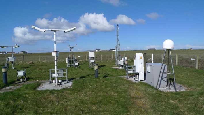
There are more than five billion satnav devices on Earth. Along with smartphones and mobile receivers, this figure includes networks of fixed receiver stations, used to improve accuracy. An ESA-led project will harness these networks to provide an ongoing overview of satnav performance from the global to national and regional scale.
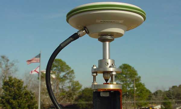
CORS station: The CORS network is a multi-purpose cooperative endeavor involving government, academic and private organizations. The sites are independently owned and operated. Each agency shares its data with NGS, and NGS in turn analyzes and distributes the data free of charge. (Photo: NOAA)
“The general assumption is that Global Navigation Satellite System (GNSS) services can always be relied on, which is true 99% of the time,” commented Michael Pattinson of Nottingham Scientific Ltd. in the United Kingdom, which is developing this new project for ESA.
“That’s fine for the ordinary smartphone user, but for safety-critical applications, in particular, we need to know exactly when systems are not performing optimally, and why.
“Current performance monitoring is often partial, based around individual signal frequencies or constellations, carried out by the service operators themselves. With our new COLOSSUS — Crowd-Sourced Platform for GNSS Anomaly Identification, Isolation and Attribution Analysis — data platform, we’ll be creating the most detailed possible picture of overall performance from the user side, covering all satellite constellations, signal frequencies and receiver types.
OS Net Station: A CORS station in Tiree, the Hebrides, part of the Ordnance Survey’s 110-strong OS Net network. (Photo: Ordnance Survey)
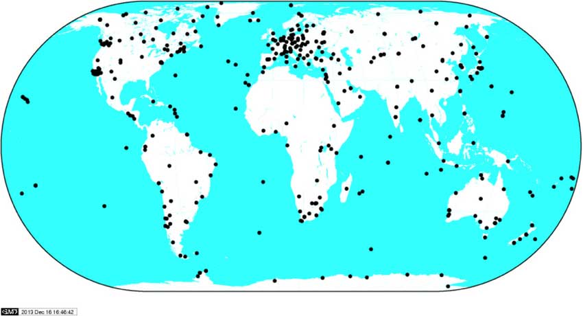
“The aim is to immediately identify system failures, faults and other errors on an immediate, autonomous basis. And we’ll do this by harnessing a resource that is already out there: gathering and analysing positioning data from networks of ‘continuously operating receiver stations’, known as CORS for short.”
There are many hundreds of these CORS stations across the globe. By performing positioning continuously at a fixed site in the landscape, they can be used as a standard, serving to identify and subtract measurement errors to boost positioning accuracy on a localised basis.
Many CORS networks have been established for scientific uses, such as the worldwide International GNSS Station (IGS) network, used as a standard geographical reference and to measure shifts in the solid Earth, oceans and ice.
Others have been set up by national mapping agencies, such as the Ordnance Survey in the UK. There are also private-sector networks, employed for improving the accuracy of services such as land surveying, air service providers, road charging or driverless cars.
IGS Global Network: the worldwide International GNSS Station (IGS) network of CORS stations is used as a standard geographical reference and to measure shifts in the solid Earth, oceans and ice.(Image: ESA)
“Each network is different,” added Pattinson. “Some make their data freely available, others involve registering or payment. We’re talking to operators to allow us to access their data in exchange for sharing our results, and they’re very interested in accessing such performance metrics.
“With measurements from so many sites, when a failure does occur we’ll be able to pin down its likely source almost immediately. Is it localised interference, or does it have a wider impact? Is it atmospheric disturbance? Is only a single model of GNSS receiver affected, or multiple types? Is it a problem with a single satellite, multiple satellites or even multiple constellations?”
The company is also deploying its own CORS receivers as an additional data source, at the same time as it develops and tests its processing algorithms. The aim is to begin testing the cloud-based COLOSSUS towards the end of 2019 and bring the service online in the first few months of 2020.
“Once the service starts, it will run continuously, just like the CORS stations themselves,” Pattinson said. “Our goal is for COLOSSUS to become a key player in GNSS performance monitoring, building up a database of all anomalies that occur and their consequences in terms of constellations, geographical regions and receiver types, to give users, service providers, and regulators an informed sense of how much ‘trust’ to place in these systems.”
This project is supported through ESA’s Navigation Innovation and Support Programme, NAVISP, applying ESA’s hard-won expertise from Galileo and Europe’s EGNOS satellite augmentation system to new satellite navigation and — more widely — positioning, navigation and timing challenges.
Satellite imagery company Soar is now allowing public access to its satellites that provide near-real time imagery all across Earth at 10-meter resolution per pixel.
Both the public and the media will now be able to see high-definition aerial views of anywhere on Earth to observe events as they happen. This includes but is not limited to environmental disasters such as wildfires, tsunamis, hurricanes and drought.
Governments will also be able to monitor activities such as the protests in Hong Kong, or illegal mining or deforestation.
Developed by geospatial experts, the map sources satellite images from the European Space Agency’s Sentinel, NASA’s Landsat feeds and the SuperView and Gaofen satellites.
As well as satellite content, the super-map will integrate imagery sourced from drone owners (drone pilots) around the world, who can earn passive income as the value of their imagery becomes realized. They can thus become a one-stop-shop for the collection, distribution, and monetization of mapping imagery from different sensors.
“The problem Soar is solving is that almost 80 percent of all mapping imagery is currently accessed through just one channel, which is, for the most part, reserved mostly for niche commercial use,” said Soar founder and CEO Amir Farhand. “In many cases, the general public only has access to resources that are not updated as frequently. Soar addresses these limitations by generating dynamic, ever-changing data on our platform.”
“Imagery taken by a drone user can be uploaded to social media, and may attract a few likes, or will sit idle on a hard drive,” Farhand said. “The same image uploaded to Soar contributes content to the seeding of the super-map, providing value to a global community, as well as generating income for the drone pilot.”
Soar’s Head of Growth, Tim Glover added, “Imagine if we could re-use that imagery in a way that was totally authentic, collaborative and most importantly, accessible to all. Soar allows anyone to view the Earth from above, meaning it’s easy to observe things like environmental changes, including drought, melting ice caps, industrial growth, natural disasters like volcano eruptions, just to name a few uses. The aim of Soar is to enable anyone to explore and discover our ever-changing world.”
With almost 10 petabytes of data already acquired, Soar is planning additional imagery as part of their growth strategy. Soar has already received several partnership requests from multinational organizations with excess satellite, aerial and drone content from across the globe.
In the near future, the platform will also feature additional data streams from higher resolution satellites, aerial imagery providers and both commercial and recreational drone operators globally.
The use of Soar is suitable for a wide range of industries and applications including agriculture, environmental, logistics, mining and insurance. However, since its beta launch in late 2018, the largest area of growth has been news and social media as users share imagery of landscape events from around the world.
Soar was founded in 2017 by Amir Farhand, an entrepreneur with more than 15 years of geospatial expertise. The Soar leadership team is headed by Chairman Guy Perkins, former co-founder of aerial imaging companies NearMap and Spookfish. Other key managers come from a wide range of industry sectors with varying backgrounds, including the Australian Special Forces, United States Air Force, Lockheed Martin, Rio Tinto, NBCUniversal and Amblin Entertainment.
Esri has launched its first major advertising campaign with a slogan Esri President Jack Dangermond introduced at the Esri User Conference in July.
“Unlike anyone else on this planet, you and your fellow GIS colleagues truly ‘See What Others Can’t.’ My sense is, it’s now time to share this perspective with the rest of the world,” Dangermond said.
The campaign includes broadcast commercials, industry magazines and newspapers, at airports, on billboards and on websites.
“We are inviting the public to join us in understanding how we see the world and how we want them to see the world,” Dangermond said. “We are hopeful this will help expand the understanding and appreciation of what our users do. We ultimately want to bring more people into our community — sharing information, working together, and finding new ways to solve the greatest challenges of today and the future.”
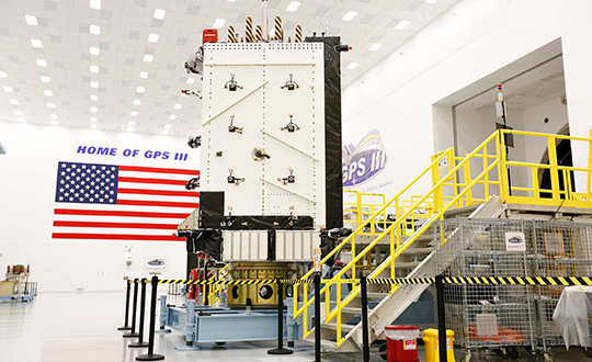
The GPS enterprise reached another major milestone on Oct. 21, when the GPS III Contingency Operations Program (COps) successfully connected with the first GPS III satellite on orbit.
The COps system will allow the Air Force to operationally command and control the new, more powerful GPS III satellites as well as legacy GPS satellites currently in the constellation. The first GPS III satellite was launched on Dec. 23, 2018.
After final system test, the Air Force approved installation of COps to command and control legacy operations at the Master Control Station at Schriever Air Force Base in Colorado Springs, Colo., and at the Alternate Master Control Station at Vandenberg, Air Force Base near Lompoc, Calif.
Trial period begins. In October 2019, the COps program received approval from Air Force Space Command’s Operations and Communications Directorate (A3/6) to enter a trial period.
The trial period includes testing COps command and control with the live, on-orbit GPS III satellite, which allows the program office to conduct developmental and operational testing needed to thoroughly verify requirements and functionality of the satellite.
The testing aims to confirm readiness for operational acceptance targeted for December 2019 and April 2020 for the GPS III satellite and COps respectively.
The GPS III COps program is managed by the U.S. Air Force Space and Missile Systems Center, Production Corps, Command and Control Systems Division, located at Los Angeles Air Force Base in El Segundo, California.
The Production Corps is an 800-plus person team managing 26 programs across the Air Force’s space portfolio.