Author: GPS World Staff

  • GPS in McMurdo Transmitter Makes Finding Planes Easier

    The The Kannad Integra Smart Pack by McMurdo Group could make it twice as easy to find missing aircraft. Photo: McMurdo Group
    The The Kannad Integra Smart Pack by McMurdo Group could make it twice as easy to find missing aircraft. Photo: McMurdo Group

    McMurdo Group, maker of end-to-end search and rescue solutions, has launched the Kannad Integra Smart Pack, an aviation emergency locator transmitter (ELT) bundle with both GPS and antenna redundancy. The product can result in Integra Smart Pack-equipped aircraft being twice as likely to be found in the event of an emergency compared to standard ELTs.

    The Kannad Integra Smart Pack includes:

    • The Kannad Integra ELT – a small, light ELT with a built-in antenna and embedded GPS receiver.
    • The new Kannad Integra e-NAV NMEA – an NMEA-standard interface cable that connects the Integra ELT to the aircraft GPS. The latest known aircraft GPS position is continually updated and stored on the interface cable itself to provide an additional level of redundancy over the embedded Integra ELT GPS data.

    Traditional ELTs rely on an aircraft’s external antenna and GPS equipment, which is subject to failure in the event of an emergency. The Integra ELT, however, can operate independently of the aircraft to provide key positioning data through its internal antenna and GPS receiver.

    With the Integra Smart Pack bundle, in the event that the Integra ELT’s internal GPS antenna is unsuccessful for any reason, the positioning coordinates from the Integra e-NAV NMEA will be used. This additional GPS redundancy will result in better location positioning and higher chance of rescue.

    “McMurdo is delighted to continue its long history of aviation search and rescue innovation with the introduction of the Kannad Integra Smart Pack,” said Christian Belleux, head of McMurdo’s Kannad Aviation Business Unit. “The Integra Smart Pack is a must-have SAR [search-and-rescue] solution to help ensure accelerated rescue response in the event of an emergency and to ultimately save more lives.”

    The Integra ELT Smart Pack is suitable for all types of aircraft with specific versions to support helicopters, general aviation planes and large commercial jets. Once activated, the Integra ELT transmits a distress signal to alert international rescue services to the emergency location via the global Cospas-Sarsat Search and Rescue satellite system, which has helped to save more than 37,000 lives since 1982.

    The McMurdo Group is exhibiting this week at Heli Expo 2015, Booth 5465, in Orlando, Fla.

  • BeiDou Numbering Presents Leap-Second Issue

    Leap-Second-O

    During preparation of playback scenarios for the upcoming leap-second event taking place in June, engineers at Racelogic identified a potential pitfall for GNSS engineers. The difficulty arises from the fact that BeiDou uses a different “day number” for the date to apply the leap second, compared with GPS and Galileo. GPS and Galileo use 1-7 as week day numbers, and BeiDou uses 0-6.

    If this fact has been missed during development, then the result is that the leap second may be implemented a day early on GNSS engines that are tracking the BeiDou constellation, said Mark Sampson, product manager for Racelogic.

    “We tested four different Beidou enabled receivers, from four leading GNSS companies, and none of them appeared to handle the Beidou leap second correctly. This included an engine which originates from China!” Sampson said. “We have since been in contact with two of these companies, who have confirmed that their hardware does have a bug in the leap-second code due to the numbering of the days.”

    The error presents itself when the receiver is running on the BeiDou constellation alone, and when the date is June 29 of this year. In some cases, the BeiDou leap second will be adjusted from 2 to 3 seconds from midnight on June 29, which should in fact occur on midnight of June 30. This will result in an error for the reported UTC time of 1 second for the period of this day. In other cases, the leap second was not implemented at all when running on BeiDou alone.

    “We have also checked the output of a BeiDou signal generator from a different simulator company, and this too uses the 1-7 range for the BeiDou leap-second date instead of the correct 0-6 range,” Sampson said. “This may explain why a number of commercial receivers appear to have been caught out by this issue.”

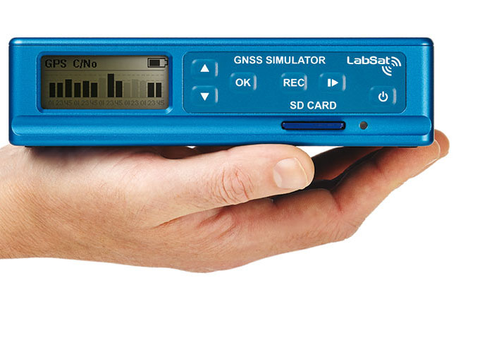
    Racelogic LabSat3 simulator.
    Racelogic LabSat3 simulator.

    In order to help companies test for this problem, Racelogic has generated simulated RF data for June 29 and 30, starting 15 minutes before midnight. “We have two sets of files. One set contains BeiDou only signals and the other contains a combination of BeiDou and GPS signals,” Sampson said. “Note that on some of the receivers we have tested, when GPS is being tracked as well, the GPS leap-second message overrides the one coming from BeiDou and applies the leap second correctly.”

    The scenarios are compatible with Racelogic’s LabSat3 triple constellation simulator, which is available on a free 15-day loan or can be purchased from Racelogic.

  • MWC 2015: Rohde & Schwarz Adds Option for Analyzing Mobile Apps to Test Solution

    MWC 2015: Rohde & Schwarz Adds Option for Analyzing Mobile Apps to Test Solution

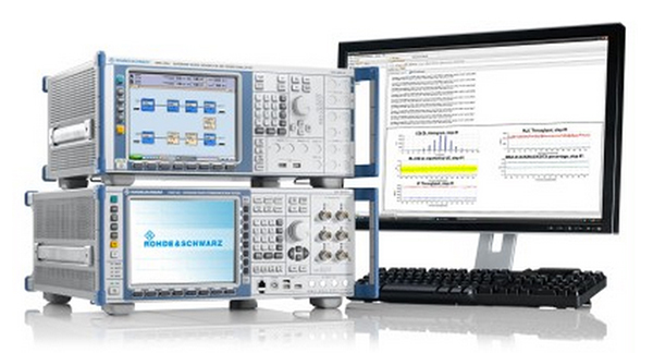
    R&S CMW-PQA Test System for Performance Quality Analysis. by Rohde & Schwarz.
    R&S CMW-PQA Test System for Performance Quality Analysis, by Rohde & Schwarz.

    Rohde & Schwarz is presenting its new over-the-top (OTT) application analysis solution at Mobile World Congress, being held this week in Barcelona, Spain. The solution enables network operators and mobile device manufacturers to quickly and easily analyze and assess the behavior of OTT apps on mobile devices the data traffic they cause.

    The additional software option is for the established R&S CMW-PQA performance quality analysis test system.

    OTT apps are applications such as YouTube and WhatsApp that use mobile networks, but are not a service offered by the network operator. Such apps can cause uncontrolled data traffic on an operator’s network and excessively drain mobile phone batteries.

    The R&S CMW-PQA OTT software now allows users to check which server the OTT app registers with, the number of connections it initiates and the network traffic volume it generates. The R&S CMW500 wideband radio communication tester, the core component of the R&S CMW-PQA, also offers a unique IP and protocol statistical analysis function that enables users to analyze how much the OTT app drains the mobile phone battery. The PACE software fromRohde & Schwarz subsidiary ipoque integrates this precise application identification function into the device.

    The intuitive user interface enables users to quickly and easily configure tests as usual, Rohde & Schwarz said. Analysis results are available in a clearly structured graphical report. Users will have a clear overview of an app’s data throughput over time, its connected and idle state information, and when RRC messages were initiated.

    The OTT solution for the R&S CMW-PQA test system is now available from Rohde & Schwarz. Customers who already have an R&S CMW-PQA do not need to purchase a hardware upgrade. A software upgrade is all that is required to add the OTT functionality to their system.

    The test setup for OTT application behavior is on display at Hall 6, Booth C40, at Mobile World Congress.

  • Google Maps Takes Street View Camera through Amazon Canopy

    Google Maps Takes Street View Camera through Amazon Canopy

    The Street View Trekker on a zipline in the Amazon Rainforest.
    The Street View Trekker on a zipline in the Amazon Rainforest. (Photo credit: Google Maps)

    New imagery of the highest canopy in the Amazon rainforest is now available on Google Maps. The Amazon rainforest is one of the most diverse ecosystems in the world, with many species high in the canopies of the forest still undiscovered.

    “Starting today, with the help of our partners at the Amazonas Sustainable Foundation (FAS), you can begin to unlock some of the wonders of the forest, by traveling from the upper canopy to the forest floor with Google Maps’ first zipline Street View collection,” wrote Karin Tuxen-Bettman, program manager, Google Earth Outreach on a March 1 blog.

    The project is part of Google’s partnership with FAS, who three years ago invited Google Maps to the Rio Negro Sustainable Development Reserve. “Their hope is that sharing the imagery of their local communities, rain forests and rivers with the world will raise awareness and support for their efforts to conserve these areas,” Tuxen-Bettman writes.

    The imagery was collected through Google Map’s Trekker Loan Program, which loans out the Street View camera and technology to tourism boards, non-profits, universities, and research organizations to help collect imagery of remote places.

    The Amazon map imagery was gathered through boat travels on 500 kilometers of rivers, hiking on 20 kilometers of forest trails and ziplining through forest canopies.

    “We hope it inspires you to embark on your own virtual expedition of the Amazon (you can leave the bug repellent at home!),” Tuxen-Bettman writes.

    The map on this page  shows where Google Maps has yet to collect Street View imagery.

    Rio Mariepauá, Brazil. (Photo credit: Google Maps)
    Rio Mariepauá, Brazil. (Photo credit: Google Maps)
  • Meitrack Offers GPS Tracker for 3G Networks

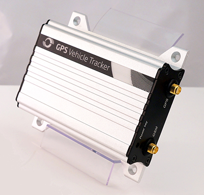
    Meitrack-T1-VEHICLE-TRACKER-WGPS tracking manufacturer Meitrack Group is introducing a tracker that runs on 3G networks. GPS trackers have been running on 2G networks, but soon many wireless carriers will discontinue the outdated 2G technology. Meitrack said it is hard at work making the transition to make all of its current trackers work on the 3G network standard.

    The first model released is the T333 GPS tracker, which offers real-time tracking, history reports, assisted GPS tracking, geofence creation, and an S.O.S. panic button. The tracker can be installed in vehicles ranging from everyday family cars, to construction and commercial trucks.

    The strong outer aluminum casing effectively secures the internal components from exposure to the elements and heat. At 190 grams, the T333 is lightweight and small enough to be securely installed in areas of minimal space, the company said. Meitrack has installed the u-Blox 7 GPS module, upgrading the processing speed and sensitivity. Not only does the T333 GPS tracker run on 3G networks, but it can also run on 2G as a backup if a 3G network is not available.

    The T333 also comes equipped with digital and analog inputs that transform the GPS tracker into a central hub where other accessories can be simultaneously attached and synced. These accessories include fuel sensors, RFID card readers, handset phones, cameras, and even LCDs and LEDs displays.

  • Deadline for ION JNC Abstracts Is Wednesday

    Abstracts are due Wednesday, March 4, for the Institute of Navigation (ION) Joint Navigation Conference (JNC), scheduled for June 22-25 in Orlando, Fla.

    The ION Joint Navigation Conference, sponsored by the ION’s Military Division, is the largest U.S. military positioning, navigation and timing (PNT) conference of the year with joint service and government participation, ION said. The event will focus on technical advances in guidance, navigation and control (GN&C), with emphasis on joint development, test and support of affordable GN&C systems, logistics and integration.

    From an operational perspective, the conference will also focus on advances in battlefield applications of GPS; critical strengths and weaknesses of fielded navigation devices; warfighter PNT requirements and solutions; and navigation warfare.

    For Official Use Only (FOUO), United States only, sessions will be held June 22-24 at the Renaissance Orlando at SeaWorld, Orlando. The U.S. only classified sessions will be held June 25 at Shades of Green Walt Disney World.

    The ION JNC features more than 200 operational presentations on a diverse array of topics. Abstracts are being accepted through March 4.

  • MWC 2015: Geotab Offers Add-On Extender for All-Vehicle Support

    Geotab, a telematics engineering company, has released its IOX-CAN extender, a plug-and-play solution that allows partners to send data from their device over a private CAN network in the vehicle, supporting integrations on all vehicle types.

    Geotab is exhibiting at Mobile World Congress 2015, at Hall 3, Stand 3J20.

    According to Geotab, Fortune 500 companies, including 40 percent of the top ten fleets and 18 percent of the top 100 fleets in North America, rely on Geotab’s solutions to improve productivity, optimize fleets through the reduction of fuel consumption, enhance driver safety, and achieve stronger compliance to regulatory changes.

    A number of companies are already leveraging the IOX-CAN extender to send data from their devices to the MyGeotab system. Geotab’s integration with Mobileye, a technology company that develops vision-based Advanced Driver Assistance Systems (ADAS) providing warnings for collision prevention and mitigation, has been upgraded with the IOX-CAN extender allowing full support for all vehicle types, including OBDII (on-board diagnostics II) vehicles.

    Geotab’s new add-on solution allows Mobileye devices to plug into Geotab’s GO6 and GO7 devices, allowing Mobileye data to be sent to the MyGeotab software platform, where it can be viewed and analyzed by dispatchers and fleet managers.

    “Our solutions are designed to make the roads safer for everyone as the issue of distracted driving continues to be a problem,” said Elad Serfaty, vice president and general manager of Mobileye Aftermarket. “Working with Geotab allows us to not only provide feedback to the driver, and with managers who can effect change where needed, but we can do this across all vehicle types.”

    “Expanding our integration capabilities and continuing our work with Mobileye is a natural evolution as more and more companies realize the benefits of fleet management,” said Neil Cawse, CEO, Geotab. “Providing collision warnings to drivers just before a crash is the first step to creating a safer driving environment for everyone.”

  • MWC 2015: RAD Demonstrates IEEE 1588 Grandmaster

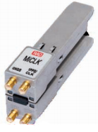
    RAD-grandmaster-MiCLK
    Photo: RAD

    Telecom company RAD will be expanding the timing synchronization capabilities of its Service Assured Access (SAA) solution when it introduces MiCLK, an IEEE 1588 grandmaster clock with a built-in GNSS receiver.The grandmaster clock is SFP-based (small form-factor pluggable).

    RAD is demonstrating the MiCLK at Mobile World Congress 2015, being held this week in Barcelona, Spain.

    “LTE and LTE-A’s stringent synchronization requirements and the growing use of small cells in 4G networks create synchronization challenges in the backhaul segment, but existing solutions are either too expensive or do not provide full network coverage,” said Ulik Broida, RAD’s vice president of marketing and business development. “With the revolutionary MiCLK, RAD makes it easy to upgrade existing backhaul networks to support LTE-A at an affordable price.”

    Many network operators prefer to use IEEE 1588-2008 (also known as Precision Time Protocol, or PTP) and synchronous ethernet to deliver accurate frequency and time throughout 4G backhaul networks. They are reluctant to install GNSS at every cell site because of practical and cost reasons, as well as concern about possible GNSS jamming and spoofing. However, accurate time distribution requires every network element between the time reference — the grandmaster — and the cell site to support IEEE 1588. This could be an expensive and complex endeavor when the grandmaster is located in a central PoP. “MiCLK allows network operators to avoid costly upgrades by bringing the grandmaster to the base station,” said Broida.

    RAD’s patent-pending MiCLK is a miniature pluggable device that responds to the needs of next-generation cellular backhaul networks, the company said. Its SFP design allows simple installation to upgrades any network device with a fully featured IEEE 1588 grandmaster, including a GNSS receiver and various redundancy options to sustain its operation in case of GNSS failure, RAD said.

    “Easily installed with minimal technical intervention, MiCLK is a versatile add-on anywhere in the network,” Broida concludes. “It is a valuable addition to mobile equipment vendor portfolios, and an ideal solution for 4G service providers in search of a quick, cost-effective way to bring accurate synchronization to small cell backhaul.”

    RAD  is exhibiting at Hall 2, Stand 2D50 at Mobile World Congress.


  • MWC 2015: Rx Networks Updates GNSS Extended Ephemeris Solution

    Rx Networks Inc., a mobile location technology and services company, announced the upcoming release of its GPStream PGPS v8 extended ephemeris solution at Mobile World Congress 2015, taking place this week in Barcelona, Spain.

    The patented technology, being used in hundreds of millions of devices, is designed to speed up the time-to-first-fix (TTFF) of any GNSS chipset while improving acquisition sensitivity in challenging environments.

    Compared to the previous version, GPStream PGPS v8 effectively doubles accuracy performance while supporting all four global GNSS constellations. GPStream PGPS v8 will be available for integration testing in the second quarter of 2015, with commercial release in the fourth quarter of 2015. (Full commercial support for Galileo will remain subject to the readiness of the constellation).

    All major GNSS semiconductor vendors are now offering or developing multi-constellation support to improve availability in challenging environments. Quad-constellation support also enables OEMs and GNSS chipset manufacturers to meet any national or regional market requirement. Availability of extended ephemeris across the four constellations is required to ensure fast TTFF and optimal sensitivity. Early lab access to the latest GPStream PGPS v8 solution from Rx Networks can help chipset manufacturers validate performance early in the development cycle and thus accelerate the time to market for their new multi-constellation chipsets.

    A key component of any extended ephemeris solution is the accuracy of the orbit and clock predictions. This accuracy is often presented as an error in meters compared to the native broadcast ephemeris transmitted by the satellites. The latest version of GPStream PGPS improves this accuracy by a factor of two, compared to its previous release. For example, day 1, 7 and 14 accuracies for GPS are now 2.8 m, 4.5 m and 11.4 m compared to 6.3 m, 12.5 m and 30.2 m previously. BeiDou and Galileo will experience similar performance. GLONASS is also significantly improved, with day 1, 7 and 14 accuracies of 1.8 m, 6.5 m and 13.7 m compared to 7.3 m, 13.4 m and 27.2 m previously.

    “Rx Networks continues to expand its relationships with major OEMs and GNSS chipset manufacturers to help them deliver innovative, multi-constellation and highly accurate GNSS performance,” said John Carley, senior product manager at Rx Networks. “This latest release reaffirms our commitment to provide best in class Assisted-GNSS solutions for the mobile market.”

    Rx Networks is exhibiting in Booth 5H75 at Mobile World Congress.

  • MWC 2015: InvenSense to Ship Positioning Software for Smartphones

    InvenSense Inc. is making available its InvenSense Positioning Library (IPL) software, designed to provide sensor-assisted positioning in places where GNSS alone cannot provide desired accuracy. Invensense is a provider of intelligent sensor system on chip for motion and sound in consumer electronic devices.

    InvenSense made the announcement at Mobile World Congress, taking place in Barcelona, Spain March 2-5.

    The IPL incorporates advancements in sensor-assisted positioning algorithms that allow use of inertial sensors to improve GNSS positioning in urban areas where satellite signals are either blocked or distorted by multipath, enabling continuous location availability while driving in underground parking lots, tunnels, or walking in urban canyons. The IPL enables continuous and accurate position, velocity and orientation in challenging operating environments.

    These sensor-assisted positioning algorithms have been designed to operate under normal pedestrian and driving use without restrictions on the device orientation. Supported pedestrian use includes handheld, hand swinging, in pocket, call mode and belt holster. The algorithms also allow any use within the vehicle, such as in cradle, cup holder or simply left on a seat. The software was designed in a way to maximize accuracy and minimize constraints on the user.

    The IPL is designed to operate with an IMU and GNSS receiver as minimum hardware. Integration with a magnetometer, barometer, and vehicle speed sensor is also available, which provides additional heading integrity as well as height and velocity accuracy for sensor-assisted positioning.

    IPL is designed for smartphones using Android, iOS, Windows and general Linux operating systems and has already started shipping commercially. The underlying navigation technology comes from years of development at Trusted Positioning Inc., which was acquired by InvenSense this past summer.

    “With more consumers using their smartphones for turn-by-turn navigation on foot or in vehicle, one of the most frustrating user experience issues is losing your GPS (GNSS) signal in an unfamiliar location or being re-routed erroneously due to multipath errors,” said Ali Foughi, vice president of Marketing and Business Development at InvenSense. “With IPL technology, high-accuracy location guidance is always available and provides smartphone OEMs with a differentiated user experience and consumers with a more reliable navigation solution.”

    The InvenSense Positioning Library is available immediately.

    InvenSense is exhibiting in booth #D61 in Hall 7 at Mobile World Congress.


  • ISRO to Launch Fourth Navigation Satellite March 9

    The Indian Space Research Organization (ISRO) is expected to launch IRNSS-1D on March 9, reports The Times of India. IRNSS-1D is the fourth navigation satellite in the Indian Regional Navigational Satellite System, and will make the constellation operable.

    The launch is tentatively planned for March 9 around 6:35 p.m. However, final go for the launch will be given by the ISRO’s Launch Authorization Board, which will meet March 6.

    IRNSS-1D will be flown into space in the Indian Polar Satellite Launch Vehicle-XL.

    The space segment of the IRNSS consists of seven satellites: three  in geostationary orbit and four in inclined geosynchronous orbit. The ground segment consists of infrastructure for controlling, tracking and other facilities. The entire IRNSS constellation of seven satellites is planned to be completed by 2015.

    Both IRNSS-1A and 1B are functioning satisfactorily from their designated geosynchronous orbital positions. The first three satellites in the IRNSS series were launched from Sriharikota on July 1, 2013, April 4, 2014, and October 16, 2014. IRNSS-1E and IRNSS-1F satellites are expected to be launched before year end.

    IRNSS is an independent regional navigation satellite system designed to provide position information in the Indian region and 1,500 kilometers around the Indian mainland. IRNSS will provide two types of service: Standard Positioning Services (SPS) — provided to all users — and Restricted Services (RS), provided to authorized users.


  • Successful Testing — and Why It Is More Important Than Ever

    By John Pottle and Neal Fedora

    John Pottle
    John Pottle

    Precision matters. While “accuracy” is somewhat one-dimensional, “precision” is multi-faceted. We submit to you that whatever area of GNSS-based location you are interested in, precision matters today and will matter more in the future. In this column, we’ll explain why this is.

    Traditional test approaches involve taking measurements to evaluate fundamental performance, for example, time-to-first-fix. As the number of critical applications that rely on positioning, navigation and timing (PNT) increases, the list of considerations for testing also grows.

    Critical applications typically require higher integrity. There are a myriad of techniques to achieve this, from adding constellations, additional frequencies, improved navigation message authentication approaches and everything in between. Examples of safety-related applications include rail, connected car and aviation. Commercially critical application examples are smartphone payment authentication and container port automation. Protecting the warfighter and ensuring mission success against growing interference and jamming are key initiatives for the military. All of these applications are becoming more sophisticated and complex, stressing the importance of precision in testing.

    Neal Fedora
    Neal Fedora

    Testing these critical applications requires:

    • Precise and clear test objectives
    • Precise definition of test approaches to explore both nominal and off-nominal conditions
    • Comprehensive test tools that include all required signal components precisely modeled and controlled
    • Test signal precision of at least an order of magnitude better than the device under test
    • Results analysis that can quickly and effectively highlight areas of interest or concern.

    Robustness against Cyber Attacks. The second area calling for more precision is the need for a more robust PNT systems in the face of increasing cyber attacks and interference. While well known in the IT world, the GNSS community is relatively unfamiliar with being targeted by hackers. Attacks on GNSS technologies are increasing in frequency and sophistication for both commercial and military users. The stakes are rising as the incidents increase from occasional (often accidental) interference to more structured and organized approaches to jamming and even spoofing.

    We’re predicting a game of cat and mouse where these cyber attacks and interference threats will continually evolve to try and stay one step ahead of the protections in place. In our view, this will call for increasingly clever and proactive threat-detection techniques in navigation systems, in addition to precise, reliable test solutions to verify them.

    Spirent’s test solutions address these growing demands by providing not only multi-GNSS signal simulators, but also inertial and interference simulators, anti-jamming test solutions, and record and replay of actual observed interference and even communications port vulnerability testing.

    In our view, the diversity of critical applications will increase, emphasizing the need for a precise approach to test planning, execution and analysis. Robust PNT is an achievable vision, and we are excited for the future.


    John Pottle is marketing director for Spirent Communications plc. Neal Fedora is director of engineering for Spirent Federal Systems Inc.