Author: GPS World Staff

  • Sixth Galileo Satellite Reaches Corrected Orbit

    Sixth Galileo Satellite Reaches Corrected Orbit

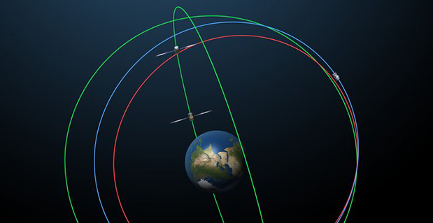
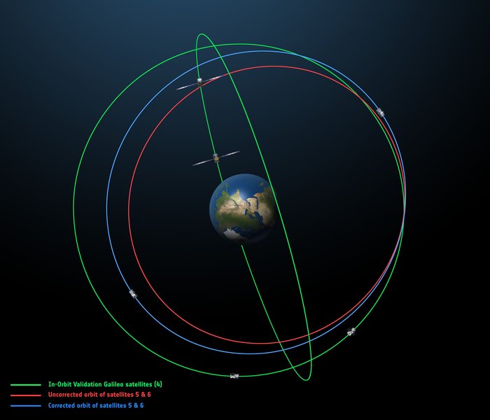
    The original (in red) and corrected (in blue) orbits of the fifth and sixth Galileo satellites, along with that of the first four satellites (green). Photo: European Space Agency
    The original (in red) and corrected (in blue) orbits of the fifth and sixth Galileo satellites, along with that of the first four satellites (green). Photo: European Space Agency

    By the European Space Agency

    The sixth Galileo satellite of Europe’s navigation system has entered its corrected target orbit, which will allow detailed testing to assess the performance of its navigation payload.

    Launched with the fifth Galileo last August, its initial elongated orbit saw it traveling as high as 25,900 km above Earth and down to a low point of 13,713 km — confusing the Earth sensor used to point its navigation antennas at the ground.

    A recovery plan was devised between ESA’s Galileo team, flight dynamics specialists at ESA’s ESOC operations centre and France’s CNES space agency, as well as satellite operator SpaceOpal and manufacturer OHB. This involved gradually raising the lowest point of the satellites’ orbits more than 3500 km while also making them more circular.

    The fifth Galileo entered its corrected orbit at the end of November 2014. Both its navigation and search and rescue payloads were switched on the following month to begin testing. Now the sixth satellite has reached the same orbit, too.

    This latest salvage operation began in mid-January and concluded six weeks later, with 14 maneuvers performed in total. Its corrected position is effectively a mirror image of the fifth satellite’s, placing the pair on opposite sides of the planet. The exposure of the two to the harmful Van Allen Belt radiation has been greatly reduced, helping to ensure future reliability.

    Significantly, the corrected orbit means they will overfly the same location on the ground every 20 days. This compares with a standard Galileo repeat pattern of every 10 days, helping to synchronize their ground tracks with the rest of the constellation.

    The test results from Galileo 5 proved positive, with the same test campaign for the sixth satellite due to begin shortly, overseen by ESA’s Redu centre in Belgium. A 20 m-diameter antenna will study the strength and shape of the navigation signals at high resolution.

    “I am very proud of what our teams at ESA and industry have achieved,” says Marco Falcone, head of Galileo system office. “Our intention was to recover this mission from the very early days after the wrong orbit injection. This is what we are made for at ESA.”

    The decision whether to use the two satellites for navigation and search-and-rescue purposes will be ultimately taken by the European Commission, as the system owner, based on the in-orbit test results and the system’s ability to provide navigation data from the improved orbits.

    The next pair of satellites is due for launch on March 27.
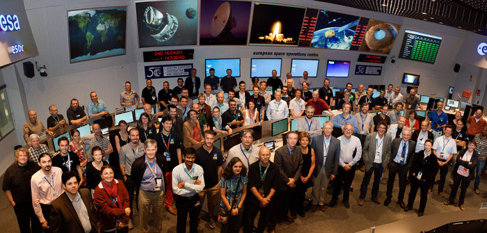
    The Galileo operations team, joined by Director General Jean-Jacques Dordain, Director of Human Spaceflight and Operations Thomas Reiter and experts from European industry, in the Main Control Room at ESA’s Space Operations Centre, ESOC, in Darmstadt, Germany, August 28, 2014. (Photo courtesy of ESA)
    The Galileo operations team, joined by Director General Jean-Jacques Dordain, Director of Human Spaceflight and Operations Thomas Reiter and experts from European industry, in the Main Control Room at ESA’s Space Operations Centre, ESOC, in Darmstadt, Germany, August 28, 2014. (Photo courtesy of ESA)
  • Trimble Introduces Correction Service for Agriculture in Europe 

    Trimble Introduces Correction Service for Agriculture in Europe 

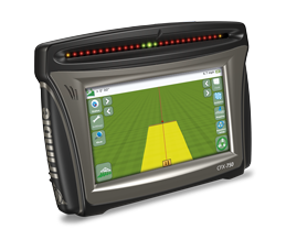
    The Trimble CFX-750 display. Photo: Trimble
    The Trimble CFX-750 display. Photo: Trimble

    Trimble announced today a new version of its CenterPoint RTX correction service that delivers convergence to 4-centimeter horizontal accuracy in less than 5 minutes. The service is designed for a variety of precision agriculture operations in Central and Western Europe, and is available for use with the Trimble CFX-750 display.

    Trimble CenterPoint RTX delivers highly accurate GNSS corrections via satellite without the need for traditional reference station RTK infrastructure, mobile data plans or additional on-machine hardware. The GNSS-enabled correction service delivers repeatable, real-time high-accuracy positions for land preparation, planting, harvesting and other high-precision farming applications.

    Enabled by the new version of RTX technology, RTX version 5.0, the fast convergence time is the result of a new region-specific atmospheric model and a dense ground reference station network. Growers will realize an approximate 80 percent improvement in RTX convergence time as compared to the RTX-standard service that typically provides 30-minute convergence time, Trimble said.

    Delivered via a new satellite broadcast covering western and central Europe, the new service will be available in Austria, Belgium, Czech Republic, France,Ireland, Germany, Luxembourg, the Netherlands, Western Poland, Southern Sweden and the United Kingdom.

    “We are continually advancing our Trimble RTX technology to improve productivity in the field,” said Patricia Boothe, general manager of Trimble Positioning Services. “Faster initialization times allow growers to start working more quickly, freeing up time to focus on other farm operations. No other satellite-delivered correction service today can offer better than 4 centimeter accuracy in less than 5 minutes.”

  • Launch Prep on Track for Galileo’s Next FOC Satellites

    Launch Prep on Track for Galileo’s Next FOC Satellites

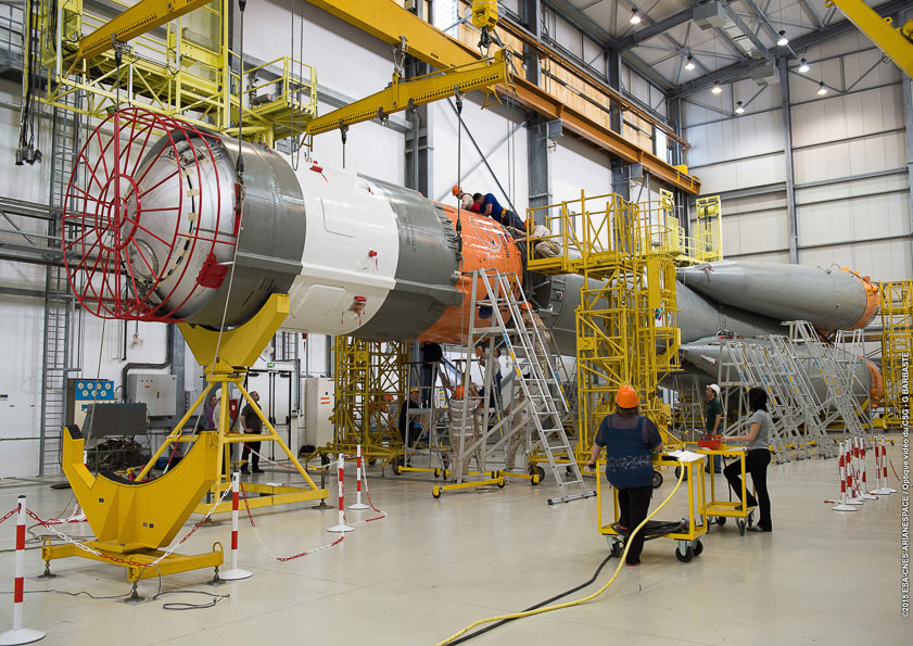
    Soyuz’ Block I third stage is mated to the launcher at the Spaceport’s MIK integration building.
    Soyuz’ Block I third stage is mated to the launcher at the Spaceport’s MIK integration building. Photo: Galileo

    Preparations for Arianespace’s next Soyuz flight, which will lift into orbit two more Galileo satellites, are in full swing at multiple locations across the spaceport in French Guiana. Work includes a key integration step for the medium-lift launcher, plus the start-up of fueling for its Galileo satellite passengers.

    Soyuz’ Block I third stage was mated to the vehicle’s core during activity today in the MIK Launcher Integration Building, concluding its basic build-up. Once the checkout process is completed, Soyuz will be transferred to the launch pad, where it will receive the two Galileo spacecraft and the Fregat upper stage, all of which are well into preparation phases of their own.

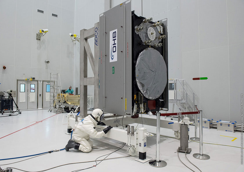
    Payload fueling began earlier this week, with Galileo 8 (Galileo FOC-FM4) — the fourth Galileo Full Operational Capability (FOC) satellite, and eighth overall — receiving its propellant load in the Spaceport’s S5A fueling and integration hall. After its sister Galileo FOC-FM3 (Galileo 7) co-passenger undergoes this same process, the two will be integrated side-by-side on a dispenser for their shared ride aboard Soyuz on March 27.

    The fueling process followed the finalization last week of FM3 and FM4’s hardware and software, as well as the charging of their batteries — which will be relied upon during the short period from launch to unfurling of these spacecraft’s solar arrays in orbit.

    The Galileo program is Europe’s initiative for satellite navigation, providing a highly accurate global positioning system under civilian control — to consist of 30 satellites in total, along with European control centers and a worldwide network of sensor and uplink stations.

    Galileo’s FOC phase — during which the network’s complete operational and ground infrastructure will be deployed — is managed and funded by the European Commission, with the European Space Agency delegated as the design and procurement agent on the Commission’s behalf.

    The FM3 and FM4 spacecraft were built by OHB System in Bremen, Germany. Their navigation payloads, which will generate the precision positioning measurements and services to users worldwide, were supplied by Surrey Satellite Technology Ltd. in Guildford, UK.

    This upcoming mission is designated Flight VS11 in Arianespace’s numbering system. It will be the company’s fourth launch carrying spacecraft for the Galileo constellation, as well as the 11th flight of a workhorse Soyuz from French Guiana since the 2011 introduction.

    the fourth Galileo Full Operational Capability (FOC) satellite is loaded with on-board propellant inside the S5A fueling and integration hall. Photo: Galileo
    the fourth Galileo Full Operational Capability (FOC) satellite is loaded with on-board propellant inside the S5A fueling and integration hall. Photo: Galileo
  • Report on Indian GPS Market Looks at Next 5 Years

    Feedback Business Consulting has released a report on opportunity in the Indian GPS current market scenario, structure and practices.

    The market scenario in “Opportunity in the Indian Global Positioning System (GPS) Market — 2015” includes current market size estimates by players, top companies, product categories, end user segments and regions. The product categories include tracking and navigation; segments include automobile, logistics, IT, ITe and mobile phones.

    The market structure section details the value of key players’ presence across products and end user segments. The market practices section explores understanding the GPS market sets in business, market trends, distribution practices and pricing.

    Some of the key companies featured in the report include Aadhithya Systems, Blaupunkt India, Caska India, Garmin India, Google Maps India and Locationguru.

    The report also provides a snapshot of key competition and past market trends with a forecast over the next five years. Anticipated growth rates and the factors driving and impacting growth are also provided.

    Market data and analytics have been derived from a combination of primary and secondary sources.

    More details and table of contents about this report can be found at Research and Markets’ website.

  • PPP Solution from NovAtel Improved for Sub-Decimeter Accuracy

    NovAtel has announced significant performance improvements to its precise point positioning (PPP) solution. NovAtel CORRECT with PPP will now offer the new TerraStar-C correction service as its exclusive source for satellite-delivered PPP correction data.

    TerraStar-C contains an enhanced correction data set that enables up to 4-centimeter accuracy and instant re-convergence when combined with the receiver error models and positioning algorithms offered by NovAtel CORRECT. This new level of PPP performance is available on NovAtel’s OEM6 receivers with firmware version 6.600.

    NovAtel CORRECT is the positioning algorithm on NovAtel’s GNSS receivers that handles corrections from a variety of sources, including real-time kinematic (RTK), PPP, spaced-based augmentation systems (SBAS) and differential GPS (DGPS). NovAtel CORRECT with PPP combines GNSS satellite clock and orbit correction data from TerraStar’s global reference station network with NovAtel’s receiver algorithms to yield robust sub-decimeter positioning without the need for nearby base stations.

    Correction data provided by TerraStar is delivered to the end user via Inmarsat satellites. With satellites visible globally, PPP is an ideal solution for precision applications where communications infrastructure is either unreliable or not available. In addition, applications where signal interruptions are common will benefit from a more robust positioning solution with the ability to quickly regain full accuracy following a temporary loss of GNSS signals, NovAtel said.

    NovAtel customers with current TerraStar-D subscriptions have the option to upgrade to the new TerraStar-C service level free of charge. The new NovAtel PPP performance level is available immediately.

  • Tallysman Application Enables Companies to Build Fleet Networks

    Tallysman Wireless has released a hosted data service for its TruFleet AVL (Automatic Vehicle Location) system, which runs on MOTOTRBO digital two-way radio networks. The new service enables Tallysman’s channel partners to build and brand their own carrier network of individual radio systems and to generate an ongoing revenue stream using any MOTOTRBO radio configuration, from conventional repeaters though to wide area trunking systems.

    TruFleet is a web browser interface for Tallysman’s fleet management AVL application that enables clear fleet overview and management. It delivers excellent web-based reporting capabilities, is very reliable, and has a rich, intuitive interface that is simple to master and to operate.

    The new TruFleet hosted data service enables channel partners to offer a cost-effective AVL solution for fleet sizes with as few as 15 subscribers.

    “The TruFleet solution generates compressed batched messages transmitted at a low reporting rate, similar to first generation Tallysman Sprite devices, but a patent-pending algorithm provides much greater data compression, conserving data bandwidth,” said John Seymour, director of data systems at Tallysman. “This enables us to to provide precise positioning at rates that are competitive with cellular systems.”

  • Veripos Offshore PPP Services Improve Accuracy

    Veripos, a supplier of high-precision GNSS positioning facilities to offshore and associated industries, has upgraded its Apex and Apex² precise point positioning (PPP) services.

    The services now typically provide users with a horizontal position accuracy of better than 5 cm and 12 cm in the vertical at the two sigma (95 percent) confidence level.

    The enhanced levels of performance, now available to all current users of Apex and Apex² without any need to upgrade, have been calculated from static data obtained in Aberdeen, Scotland, where Veripos is headquartered, as well as Houston, Texas, and Singapore. Veripos said that accuracies may vary with observing conditions, however.

    The improved accuracy follows a major upgrade of the entire Veripos global reference station network for tracking all GNSS signals, together with introduction of new receivers and geodetic antennas for delivery of better measurement quality resulting from refinements to algorithms and software used to derive necessary GNSS orbit and clock corrections.

    Designed to meet all offshore positioning and navigation applications, the dual-beam Apex and Apex² PPP services are relayed via seven geostationary communications satellites to ensure continuous availability and service redundancy while providing access to both GPS and GLONASS constellations. Positional accuracy is maintained regardless of user location, Veripos said.

  • Connor-Winfield Offers TCXO for Compliance with ITU-T G.8262

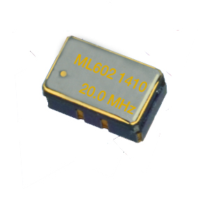
    Connor-ML602-TCXO
    Photo: Connor-Winfield

    Connor-Winfield is offering two new temperature compensated crystal oscillator models. TL602 and ML602 TCXO models are designed for use in conjunction with 0.1-Hz (and higher ) filter bandwidths for compliance with T1-based hierarchy specifications such as ITU-T G.8262 Option 1 and 2 ECC and ITU-T G.813 Option 1 and 2 SEC, Stratum 3 for Sonet, IEEE1588 and Synchronous Ethernet. CW’s TCXO line utilizes analog temperature compensation for excellent short-term stability characteristics, the company said.

    The TL602 and ML602 TCXOs maintain 280-ppb pk-pk frequency stability over the industrial temperature range of -40 to +85C. They are also excellent frequency reference choices for small cell, wireless and instrumentation applications, Connor-Winfield said.

    Features:

    • Available frequencies are 10 MHz, 12.8 MHz, 19.2 MHz, 19.44 MHz, 20 MHz and 24.576 MHz.
    • LVCMOS or clipped sine.
    • Fixed output or Voltage control.
    • Meets MTIE and TDEV masks measured at 0.1-Hz bandwidth.
    • Short term stability 1×10⁻¹⁰ performance.
    • 280-ppb peak-to-peak temperature stability over the full industrial temperature range.
    • Sub-300 ps jitter performance over 12 kHz-20 MHz band.
    • Lifetime accuracy of +/- 4.6 ppm.
    • Full ROHS and REACH compliance.
    • 7×5 mm (TL602) or 5×3.2 mm (ML602) packaging options.
  • Galileo Boosters Prepped for March 27 Launch

    Two more full operational capability (FOC) Galileo satellites are scheduled for launch March 27. This video shows the four first-stage boosters of the Soyuz launcher being assembled in Europe’s Spaceport in French Guiana. Assembly takes place on a horizontal basis, in the Russian manner. The video shows four thrusters assembled around the main body. After takeoff, the engines burn for 120 seconds and then are dropped. The thrust is transferred to the main body by a ball joint located above the propeller of the cone-shaped structure.

  • FAA UAS Proposal Open for Comments Until April 24

    The public has until April 24 to comment on a framework of regulations proposed by the Federal Aviation Administration (FAA) in February. The regulations would allow routine use of certain small unmanned aircraft systems (UAS) in today’s aviation system, while maintaining flexibility to accommodate future technological innovations, the agency said.

    The FAA proposal offers safety rules for small UAS (under 55 pounds) conducting non-recreational operations. The rule would limit flights to daylight and visual-line-of-sight operations. It also addresses height restrictions, operator certification, optional use of a visual observer, aircraft registration and marking, and operational limits.

    The new rules would not apply to model aircraft. However, model aircraft operators must continue to satisfy all of the criteria specified in Sec. 336 of Public Law 112-95, including the stipulation that they be operated only for hobby or recreational purposes.

    The public will be able to comment on the Small UAS Notice of Proposed Rulemaking for 60 days from the date of publication in the Federal Register. The proposed regulation was published for public comment on February 23, and comments will be accepted through April 24.

    Read an overview of the Small UAS NPRM (PDF).

    Read the complete Small UAS NPRM (PDF).

  • IRNSS-1D Launch Rescheduled for March 29

    The launch of the fourth satellite for the Indian Regional Navigation Satellite System, previously scheduled for March 9, has been postponed until March 29 at 13:00 UTC. The delay is due to the replacement of a faulty telemetry transmitter on the satellite.

    “We are targeting the last few days of March for the launch. A team is working on a new telemetry transmitter to replace the [faulty] one that failed in the satellite. After fixing it, all numerous tests that we conducted earlier must be repeated,” M.Y.S. Prasad, Director of the launch unit, Satish Dhawan Space Centre, Sriharikota, told The Hindu on Tuesday.

    The launch, originally scheduled for March 9,  was delayed March 4 when routine checks found a transmitter malfunctioning. The ISRO delayed the flight and removed the satellite from its launcher to put a new transmitter.

    IRNSS-1D will be fourth in the seven-spacecraft IRNSS constellation.

    — With information provided by the CANSPACE listserv.

  • New Version of GAPS PPP Software Available

    A new version of the online GAPS precise point positioning software is now available. GAPS — GPS Analysis and Positioning Software — is offered by the University of New Brunswick Geodesy and Geomatics Engineering Department.

    The latest release provides capabilities for handling GPS data files in both RINEX 2 and 3 formats, whether Hatanaka-compressed or not, along with a number of receiver raw file formats. Also, additional input and output data-quality verification is now performed.

    More information on the release can be found here, and the new version is available here.