Anritsu plans to showcase a sophisticated, cloud-based connected car system for fleet tracking at Mobile World Congress 2015, which will be held in Barcelona March 2-5. The system was developed by the University of Hertfordshire in the UK with the help of network simulation technology from Anritsu.
The system will be demonstrated using a GNSS simulator from Spectracom to provide location information to the system being tested.
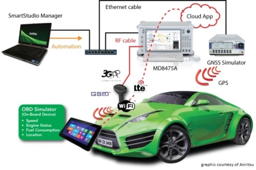
The connected car demonstration will show a car’s diagnostics system connecting to the cloud via a simulated LTE network environment provided by Anritsu’s mobile network simulator, the MD8475A. An application in the cloud enables a fleet manager on any Internet-connected device to view the location and operating parameters of any vehicle in the fleet in real time.
The MD8475A enables the university’s development team to test, from their Hertfordshire laboratory and with a single instrument, how the system’s in-car LTE modem would perform in mobile networks all across the world, and operating according to all major worldwide standards.
The combination of the MD8475A and the Spectracom simulator provides a complete test environment, to simulate any global location, and any type of cellular connectivity, to ensure correct operation of the system. This test bed will showcase the effectiveness of a complete wireless test-bed solution, to enable cost-effective development testing, product validation, and customer experience evaluation within a single system.
Anritsu Corporation has been a communications provider solutions for more than 110 years, with test and measurement solutions including wireless, optical, microwave/RF and digital instruments, operations support systems and solutions that can be used during R&D, manufacturing, installation and maintenance.
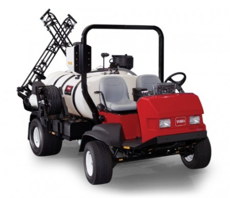
Topcon Positioning Group is partnering with The Toro Company to develop a GPS-guided sprayer that Toro will start selling to the commercial equipment marketplace this summer. The GeoLink system will be available for the Toro Multi Pro 5800 initially, with plans to offer it for a broader range of Toro sprayers in the future.
“We’re thrilled to partner with Toro on our debut in the turf spraying marketplace,” said Jason Killpack, director of business development, strategic partnerships for Topcon.
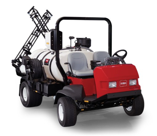
The Toro Multi Pro 5800 sprayer will get Topcon GPS guidance.
“This new system, which builds upon Topcon innovations developed for precision agriculture, is an excellent example of how positioning technologies can benefit non-traditional industries. We are taking proven precision agriculture technology and providing it as a resource for Toro to employ in its market,” Killpack said.
“In addition to working in tandem with Toro to develop this exciting new product, it also provides us the opportunity to expand our TopNETlive network, which is a key initiative within our organization.” The TopNETlive network is a subscription-based, real-time, GNSS reference network delivering high-quality correction data to rovers used for surveying, construction, GIS mapping and agricultural applications throughout North America.
“We started by understanding customer needs, and then selected Topcon as a partner to develop an integrated user-friendly solution,” said Jace Bertsch, marketing manager for Toro. “We are very excited to offer the unique features that have been engineered into this system, and are confident that GeoLink will be successfully deployed in both the golf and sports field market segments. Simply put, GeoLink ensures accurate and consistent coverage, which translates into exceptional results and reduced chemical costs.”
Farmers Edge Inc., a precision agriculture and independent data-management company, has acquired GranDuke Geomatics Ltd. of Lethbridge, Alberta. The agreement was finalized on Jan. 9, giving control of the geospatial solutions and software development company to Farmers Edge.
Headquartered in Winnipeg, Canada, Farmers Edge has operations in North and South America, Australia, Russia and Eastern Europe. The company said it’s goal is to increase growers’ profitability maintaining an environmentally sustainable approach by leveraging advanced precision tools and big data analytic solutions.
Farmers Edge offers its Precision Solutions package for every agribusiness, crop and geography. Precision Solutions is a turnkey comprehensive package that includes variable rate technology, field centric weather monitoring, high-resolution satellite imagery, in-field telematics and real boots on the ground. Farmers Edge allows farmers to collect, store and transfer data, make advanced management decisions and measure results.
Fertilizer and yield maps provided by GranDuke Geomatics Ltd. are part of the Precision Solutions product line, offering growers an increase in efficiency through automated workflows, specialized software design and cloud-based data processing.
GranDuke Geomatics Ltd. was founded in 2012 by Guy Duke and Kevin Grant, and with the assistance of the National Research Council offers customized software solutions and geospatial applications to clients in precision agriculture, environmental monitoring, and oil and gas. With 22 employees, GranDuke Geomatics Ltd. will continue to provide advanced GIS and yield data processing services for Farmers Edge.
“The acquisition of GranDuke is a huge opportunity for our company and our staff,” Grant said. “Farmers Edge is a world-class, fast growing precision agriculture company. We are excited to be a part of their continued growth.”
“This acquisition is the culmination of a lot of hard work and late evenings providing Farmers Edge with rapid software development and quick product turn-around times for their data analysis and mapping,” Duke said.
“We’re really excited about the acquisition of GranDuke Geomatics because they bring an outstanding software engineering team and valuable ag technology IP to the table,” said Wade Barnes, president and CEO of Farmers Edge Inc. “We are now incorporating this IP into our decision support tools that bring all the information together to make a meaningful impact on production. We want our growers to have all resources they need to attain the best results from their investment.”
Kalashnikov produces a well-known assault rifle. The acquisition of the UAV companyZALA Aero is part of the company’s development strategy through 2020, according to a statement released to Defense News.
“Based off Kalashnikov Concern and ZALA Aero company, we plan to develop and manufacture drones, mobile and earth-based management stations,” said Aleksey Krivoruchko, Kalashnikov Concern CEO.
“Our main product here will be intelligence-gathering pilotless airplanes, helicopters and aerostats. The decision to purchase control stake of ZALA Aero to widen our product line has been made as a part of the strategy of Kalashnikov corporate development through the year 2020 and as a part of the process of developing new sectors of our market.”
The UAVs will operate to secure state borders, intelligence gathering and rescue operations, as well as special operations, the report states.
Volvo Cars has a complete system solution that makes it possible to integrate self-driving cars into real traffic, with ordinary people in the driver’s seat. The automaker presented its planned system in an online press conference Feb. 19.
“We are entering uncharted territory in the field of autonomous driving,” said Peter Mertens, senior vice president of Research and Development, Volvo Car Group. “Taking the exciting step to a public pilot, with the ambition to enable ordinary people to sit behind the wheel in normal traffic on public roads, has never been done before.”
As the Drive Me project enters its second year, Volvo is moving toward its goal of placing 100 self-driving cars in the hands of customers on selected roads around Gothenburg by 2017. The public pilot — a collaboration between legislators, transport authorities, a major city and a vehicle manufacturer — is a central component of Volvo’s plan to achieve sustainable mobility and ensure a crash-free future.
Early prototype cars are now being tested on the DriveMe route in and around Gothenburg, Sweden.
Volvo’s production-viable autonomous driving system is based on a complex network of sensors, cloud-based positioning systems and intelligent braking and steering technologies.
“Autonomous driving will fundamentally change the way we look at driving. In the future, you will be able to choose between autonomous and active driving,” Mertens said. “This transforms everyday commuting from lost time to quality time, opening up new opportunities for work and pleasure.”
Volvo’s autopilot system is designed to be reliable enough to allow the car to take over every aspect of driving in autonomous mode, Volvo said. The technology advances a crucial step beyond the automotive systems demonstrated so far since it includes fault-tolerant systems, the carmaker said.
“It is relatively easy to build and demonstrate a self-driving concept vehicle, but if you want to create an impact in the real world, you have to design and produce a complete system that will be safe, robust and affordable for ordinary customers,” said Erik Coelingh, technical specialist at Volvo Cars.
The main challenge is to design an autopilot that is robust for traffic scenarios as well as for technical faults that may occur. The driver can’t be expected to suddenly intervene in a critical situation. Initially, the cars will drive autonomously on selected roads with suitable conditions, such as without oncoming traffic, cyclists or pedestrians.
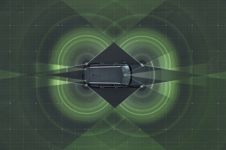
Volvo’s system generates exact positioning and a complete 360° view of the car’s surroundings through a combination of radars, cameras and laser sensors. A network of computers processes the information, generating a real-time map of moving and stationary objects in the environment.
“Making this complex system 99 percent reliable is not good enough. You need to get much closer to 100 percent before you can let self-driving cars mix with other road users in real-life traffic,” Coelingh said. “Here, we have a similar approach to that of the aircraft industry. Our fail-operational architecture includes backup systems that will ensure that the autopilot will continue to function safely if an element of the system were to become disabled.”
For example, the probability of a brake system failure is very small, but a self-driving vehicle needs a second independent system to brake the vehicle to a stop, because it is unlikely that the driver will be prepared to press the brake pedal.
On the road, the complete technology solution is designed to handle even the most complicated scenarios, from smooth commuting to heavy traffic and emergency situations, Volvo said. “Just as good drivers would, potentially critical situations are approached with sensible caution. In a real emergency, however, the car reacts faster than most humans,” Coelingh said.
When autonomous driving is no longer available — because of weather, technical malfunction or the end of the route has been reached — the driver is prompted by the system to take over again. If the driver is incapacitated for any reason and does not take over in time, the car will bring itself to a safe place to stop.
Volvo expects that autonomous driving could cut fuel consumption, improve traffic flow, and open up possibilities for urban planning and more cost-efficient investments in infrastructure.
“Developing a complete technological solution for self-driving cars is a major step. Once the public pilot is up and running, it will provide us with valuable knowledge about implementing self-driving cars in the traffic environment, and help us explore how they can contribute to sustainable mobility,” Coelingh said. “Our smart vehicles are a key part of the solution, but a broad societal approach is vital to offer sustainable personal mobility in the future. This unique cross-functional cooperation is the key to a successful implementation of self-driving vehicles.”
Drive Me system components:
The 76-GHz frequency-modulated, continuous wave radar is placed in the windscreen and combined with a camera to detect objects on the road. Four radars behind the front and rear bumpers locate objects in all directions. Long-range radars in the rear ensure a good rearward detection of vehicles in parallel lanes.
Sensor technologies. Volvo Cars is developing a holistic solution that generates exact positioning and a complete 360-degree view of the car’s surroundings. This is achieved by a combination of multiple radars, cameras and laser sensors. A redundant network of computers processes the information, generating a real-time map of moving and stationary objects in the environment.
Precise positioning is based on this surround information together with GPS and a high-definition 3D digital map that is continuously updated with real-time data. The system is reliable enough to work without requiring driver supervision.
Combined radar and camera. The combined 76-GHz frequency-modulated continuous wave radar and camera placed in the windscreen is the same as that in the new XC90. This system reads traffic signs and the road’s curvature and can detect objects on the road such as other road users.
Surround radars. Four radars behind the front and rear bumpers (one on each corner of the car) are able to locate objects in all directions. By sweeping both left and right, transmitting waves that bounce off signs, poles, and tunnels, they monitor a full 360-degree around the car.
360-degree surround vision. Four cameras monitor objects in close proximity to the vehicle. Two are under the outer rear-view mirrors, one is in the rear bumper and one is in the grille. Besides detecting objects at close range, these cameras monitor lane markings. The cameras have a high dynamic range and can handle quick changes in lightning conditions, such as when entering a tunnel.
Multiple beam laser scanner. This sensor system is placed in the front of the vehicle, below the air intake. The scanner can identify objects in front of the car and ensures very high angle resolution. It can also distinguish between objects. The laser sensor has a range of 150 meters for vehicles and covers a 140-degree field of view.
Trifocal camera. A trifocal camera placed behind the upper part of the windscreen is three cameras in one, providing a broad 140-degree view, a 45-degree view and a long-range, yet narrow, 34-degree view for improved depth perception and distant-object detection. The camera can spot suddenly appearing pedestrians and other unexpected road hazards.
Long-range radars. Two long-range radars placed in the rear bumper of the car ensure a good rearward field of view. This technology is useful when changing lanes because it can detect fast-moving vehicles approaching from far behind.
Ultrasonic sensors. Twelve ultrasonic sensors around the car are used to identify objects close to the vehicle and support autonomous driving at low speeds. The sensors are based on the technology used for current park-assist functions enhanced with advanced signal processing. This technology is useful for detecting unexpected situations, such as pedestrians or hazards on the road close to the car.
High-definition 3D digital map. A high-definition 3D digital map provide the vehicle with information about the surroundings, such as altitude, road curvature, number of lanes, geometry of tunnels, guard rails, signs, and exits. The position geometry is in many cases at centimeter level.
High-performance positioning. The high-performance GPS is one part of the positioning control that is enhanced by a combination of an advanced GPS, a three-degrees-of-freedom accelerometer and a three-degrees-of-freedom gyro. By matching the 360-degree image created by the multitude of sensors with the map image, the car will get the information about its position in relation to the surroundings.
By combining the information from the sensors and the map, the Drive Me car is able to choose the best course in real time, factoring in variables such as the curvature of the road, speed limit, temporary signs and other traffic.
Cloud services. The cloud service is connected to the traffic authorities’ control center. This ensures that the most up-to-date traffic information is always available. Control center operators also have the ability to tell the drivers to turn off the autonomous drive mode if necessary.
Driverless cars are now traveling Britain’s public roads, according to a report in the Providence Journal. Four prototype self-driving cars took to the country’s highways, launching Britain’s first public trials. Still, with regulatory and legal hurdles, officials said fully driverless cars are unlikely to be used on British roads until 2030.
Four types of autonomous vehicles are being tested, including a shuttle that looks like a larger golf cart and a compact two-seater “pod.” Journalists took rides on the shuttle, which traveled a public square outside central London’s O2 Arena.
The project was “still in the early days,” Transport Minister Claire Perry told the Associated Press, but she added the new technology has the potential to make roads safer and attract global investment.
Driverless cars are also being tested in U.S. cities by companies including Google, and Apple and Sony are at least exploring autonomous vehicles. Meanwhile, automakers such as Audi, Mercedes-Benz and Nissan are developing autonomous cars, and Volvo expects to test its self-driving cars on customers by 2017. The widely discussed goal is to have autonomous vehicles on the market by 202o.
Fleetmatics Group now offers new features for its mobile field service management solution Fleetmatics WORK. The enhancements help businesses to operate more efficiently and maximize their resources, the company said. Fleetmatics is a global provider of mobile workforce solutions for service-based businesses.
This latest release dramatically accelerates time to cash for SMB operators by embedding a payment link directly into the emailed invoice that is generated. With this new online payment powered by Stripe, Fleetmatics WORK closes the loop between job completion and payment. Jobs can now be invoiced from the field instantly via email and transactions can be processed securely in real time.
Fleetmatics WORK has added integrations with QuickBooks Online in the U.S. and MYOB AccountRight Live in Australia and New Zealand. Now, when jobs are completed, the invoices flow seamlessly from Fleetmatics WORK to the user’s accounting system and updated client information is sent between the systems to keep all data in sync, Fleetmatics said.
Business owners now have additional tools to manage fieldworkers. As service businesses grow, it becomes increasingly important for them to have manageable views of their field. New fieldworker tags in Fleetmatics WORK give dispatchers clear visibility to sort schedules and make assignments based on best fit.
“Our mission is to help customers achieve greater levels of productivity, service and efficiency,” said Jonathan Durkee, Vice President of Product Management for Fleetmatics. “With the new online payments, seamless accounting integrations and increased fieldworker visibility we’re enabling field service businesses to drive even stronger results.”
Free training and ongoing support is available to all users through Fleetmatics’ award-winning customer service, which provides education and best practices for transforming data into actionable business intelligence.
Galileo’s Ground Mission Segment in the Fucino Control Centre in Italy oversees Galileo navigation services and satellite payload operations.
News from the European Space Agency
In Roman times the milestone was the central method of navigation, with all distances fixed from a ‘golden milestone’ in the imperial capital. Today, navigation satellites have become the modern equivalent of milestones — but Rome still has a role to play.
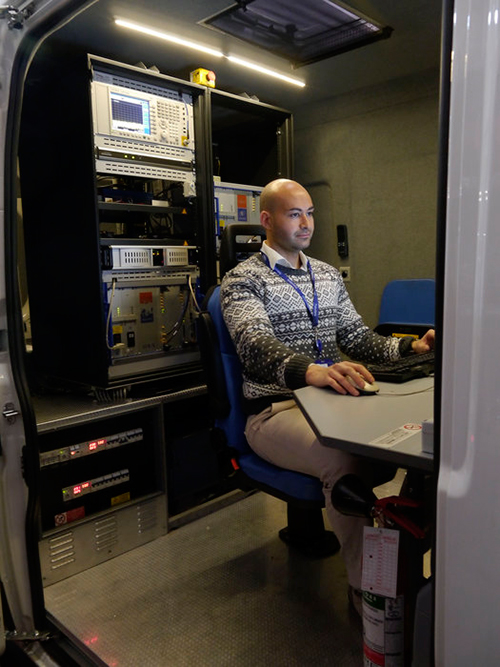
Inside the Galileo System Evaluation Equipment facility, based at Thales Alenia Space in Rome.
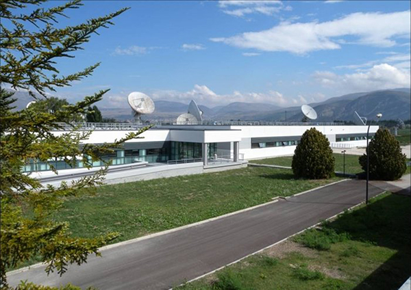
The Thales Alenia Space plant in the eastern suburbs of Rome is home to the Galileo System Evaluation Equipment facility, which provides a troubleshooting platform for the Galileo ground network and an assessment of the performance of Europe’s under-construction satnav constellation.
Based in the main plant building, it is equipped with a secure data link to the Galileo Control Centre in Fucino, 90 km away, which oversees Galileo navigation services. This link gives it direct access to all the data gathered by the global ground segment, from the sensor station data to the navigation messages uplinked to the satellites, including satellite orbits and onboard clock corrections.
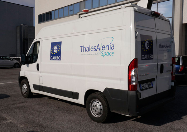
The facility can then apply separate software to these inputs, rather than that used in the Galileo Mission Segment, to provide a “second opinion” on Galileo performance. In addition, a van measures Galileo performance in the field, gathering data across a range of vehicle and rural environments.
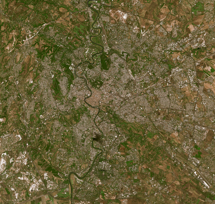
The River Tiber flows through the historic centre of Rome, seen in high-resolution detail by France’s Spot-5 satellite.
“The facility is being routinely operated by the Thales Alenia Space team,” explains Enrico Spinelli, overseeing it on the ESA side. “It is being upgraded to automatically process the data received from the Galileo control centres, perform troubleshooting analyses and provide inputs for the monthly Early Service Key Performance Indicators report. These reports are provided in turn to the European Commission’s European Global Navigation Satellite System Agency, as part of Galileo’s Early Services preparatory activities.”
The facility made the Rome area one of the two main centres of activity during Galileo’s In-Orbit Validation phase, along with the ESA’s ESTEC technical centre in Noordwijk, the Netherlands. In-Orbit Validation was the extensive system testing performed on the ground during late 2012 and early 2013 to ensure the embryonic four-satellite system was performing as designed, including Galileo’s historic first position fix of longitude, latitude and altitude on March 12, 2013.
The Galileo System Evaluation Equipment facility hosted at Thales Alenia Space in Rome is equipped with a van measures Galileo performance in the field, gathering data across a range of vehicle and rural environments.
“The facility was developed for that phase, but has performed so well that it was decided to keep it in operation during succeeding phases,” adds Enrico. “Along with its intended use in monthly reporting, its direct access and processing of Galileo Control Centre data will make it a powerful tool for system troubleshooting for both Galileo’s upcoming services. It can give us independent analyses of factors such as the availability and quality of data from Galileo Sensor Stations and the Orbit Determination and Time Synchronisation process which keeps the overall Galileo system in sync.
“It can also allow us to check the accuracy of software models used to compensate for ionospheric delay, the accuracy of almanacs charting satellite orbital positions and to analyze the efficiency of the ground-to-satellite contact plans for the uplink of the navigation message which the satellites rebroadcast, even to verify the navigation message is being broadcast in its correct structure.”
The improved facility should help to ensure the timely and reliable introduction of initial Galileo services, planned in 2016.
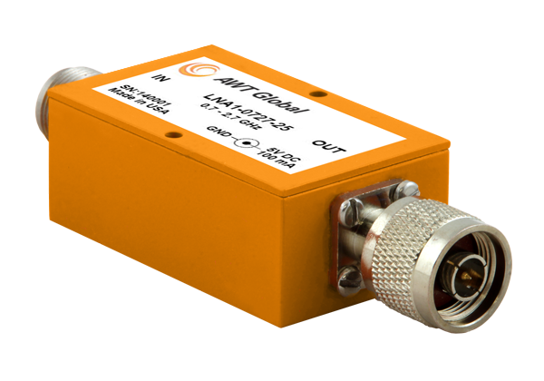
AWT Global has launched a new product line of low noise amplifiers: the LNA1 Series.
The new compact Low Noise Amplifiers (LNAs) are suited as RF measurement amplifiers and for signal boosting applications. LNA1 amplifiers cover telecommunications frequency bands from 700 to 2700 MHz. High gain of 25dB (+/-3) makes them perfect for applications like interference hunting.
“Due to its small form factor, LNA1 is well suited for mobile applications,” said Wolfgang Damm, president of AWT Global. ”LNA1 has been designed with power requirements of 5V/100mA, so it can be supplied by any USB port, standard at most portable instruments like spectrum analyzers.”
LNA1-0727-25 covers a frequency range of 700 to 2700 MHz. Impedance is 50 Ohms and VSWR ratio is 2.2:1. LNA1 features 25 dB (+/-3) of gain and 2.0 dB NF. Size is: 1.5” x 1.0“ x 2.5” ( 38 x 25 x 64 mm). Both, input and output comes standard with N-Type connectors, INP N(f) / OUT N(m). Other connector types are available on request. Power is supplied with a common 5.5 OD, 2.1 ID connector. AWT Global’s LNA1-0727-25 LNAs are available for sales immediately.
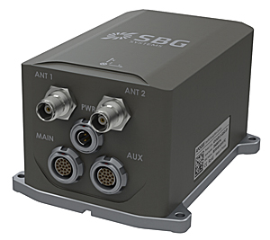
SBG Systems has released the Apogee Series, its most accurate inertial navigation systems based on robust and cost-effective MEMS technology. The INS/GNSS integrates the latest generation of MEMS sensors and a tri-frequency GNSS receiver. Apogee achieves 0.008° in roll and pitch in real-time and 0.005° in post-processing. With two antennas, it delivers a robust and accurate heading.
Four models compose the Apogee line.
The Apogee-A provides only orientation data.
The Apogee-N additionally embeds a GNSS receiver; it is a compact solution with one antenna for land and aerial applications.
The Apogee-D embeds a dual-antenna GNSS receiver for accurate heading under low dynamics conditions.
The Apogee-E delivers navigation data when connected to an external GNSS receiver or to the SplitBox with integrated GNSS.
Mobile Mapping. Apogee can be precisely synchronized with LiDAR equipment because of a UTC time-stamping accurate to 1 microsecond. This integrated INS/GNSS provides optimal position in multipath environment or during GNSS outages, thanks to a tight GNSS integration and the continuous fusion of inertial and odometer data. To get the required positioning accuracy, Apogee supports RTK and Precise Point Positioning services (Omnistar, Terrastar, and more).
Aerial Mapping and Remote Sensing. With very low noise gyroscopes, low latency, and high resistance to vibrations, the Apogee allows aerial surveys by plane or helicopter. It provides real-time orientation and position data with direct fusion of inertial and GNSS information. Compact, lightweight and low power, the Apogee is easy to install, and has an embedded web interface for configuration.
Post-processing. Orientation and position data can be recorded in the Apogee data logger. At the office, the user imports data in the post-processing software. This tool gives access to several RTK networks and reference station offline data (such as VRS and CORS.) Additionally, it enhances orientation and position accuracy by a complete “backward/forward” calculation.
“SBG Systems manufactures inertial systems from the concept to the production. The Apogee benefits from our high level of expertise in integrated design, IMU calibration, testing, and filtering,” said Alexis Guinamard, CTO of SBG Systems.
All models are available for order. Below is a promotional video with more information.
Apple is working on its own autonomous car, according to Reuters. An auto industry source told Reuters that the tech giant is gathering information and parts to make a prototype for the autonomous electric vehicle — the entire car, not just automotive software or components.
“They don’t appear to want a lot of help from carmakers,” said the unnamed source.
Apple is gathering advice on parts and production methods, focusing on electric and connected-car technologies, while studying the potential for automated driving, the source told Reuters.
“Fully automated driving is an evolution. Carmakers will slowly build the market for autonomous cars by first releasing connected and partially automated cars,” the source said. “Apple is interested in all the potential ways you can evolve the car; that includes autonomous driving.”
Meanwhile, Sony is also turning to autonomous vehicles, according to USA Today. The electronics giant is teaming up with Japanese robotics company ZMP to develop self-driving automobiles, reports the Financial Times. Sony invested 100 million yen (about $842,000) in ZMP.
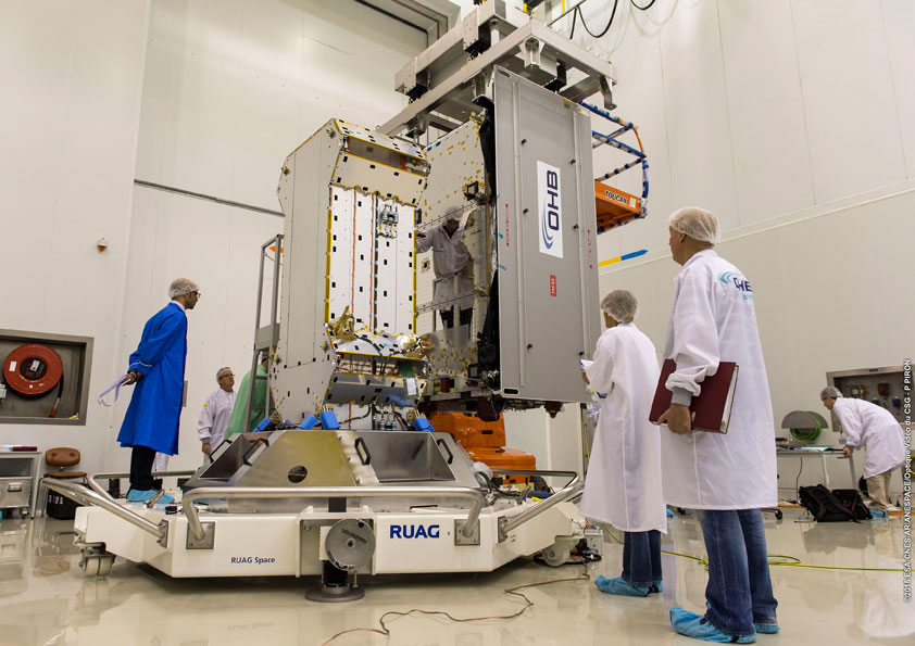
The Flight Model #3 (FM3) spacecraft is moved for positioning on the payload dispenser. (Photo credit: Arianspace)
The third and fourth Galileo Full Operational Capability (FOC) satellites are a confirmed “fit” for their Arianespace Soyuz launch March 27, having made initial contact with the mission’s dual-payload dispenser in French Guiana, according to Arianespace.
The fit check was completed over a two-day period inside the Spaceport’s S1A payload preparation building. The two satellites were installed separately, with the Flight Model #3 (FM3) spacecraft integrated on — and subsequently removed from — the dispenser on Feb. 9. Flight Model #4 (FM4) underwent the same process the following day.
The payload dispenser for Galileo was developed by RUAG Space Sweden for Arianespace, and carries one satellite on each side. It will deploy the spacecraft during the Soyuz launch by firing a pyrotechnic separation system to release them in opposite directions at the orbital insertion point.
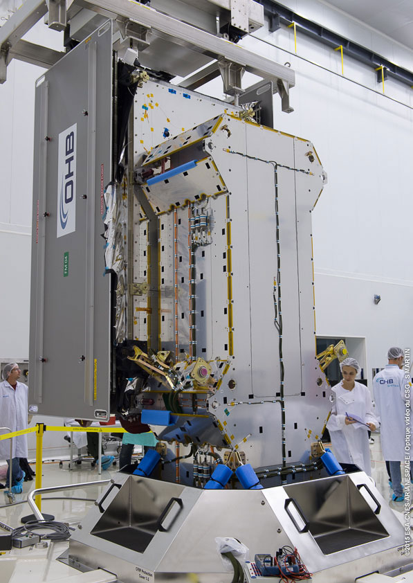
Flight Model #4 (FM4) after its integration. (Photo credit: Arianspace)
Final integration on the dispenser is to be performed during upcoming processing at the spaceport, and will be followed by the completed unit’s installation on Soyuz.
The March 27 mission — designated Flight VS11 in Arianespace’s numbering system — will be the company’s fourth launch carrying spacecraft for the Galileo constellation. FM3 and FM4 were built by OHB System, with Surrey Satellite Technology Ltd. supplying their navigation payloads.
The Galileo network’s complete operational and ground infrastructure will be deployed during the Full Operational Capability phase, which is managed and funded by the European Commission. The European Space Agency has been delegated as the design and procurement agent on the commission’s behalf.