u‑blox has announced the NEO-M8T and LEA-M8T precision timing modules, which are able to generate a precise reference clock with <20 ns accuracy. The receivers offer high sensitivity (-157 dBm signal acquisition with assisted GNSS) that allows quick start-up inside structures with limited sky view. The precise reference clock is derived from multi-GNSS including GPS, GLONASS, and BeiDou.
The LEA-M8T module is footprint compatible with existing LEA-5T/6T designs, facilitating easy upgrade. The NEO-M8T is optimized for timing applications requiring low power consumption and long battery life such as geophones used for seismic field measurements. Both compact, surface-mount modules meet stringent requirements for reliability, accuracy and low power consumption.
“These new modules are the industry’s highest performance GNSS timing modules in terms of accuracy, reliability and power consumption,” said Thomas Nigg, Vice President of Product Marketing at u-blox, “The new modules are perfect solutions for mission-critical infrastructure systems including mobile communication networks, power generation and distribution systems and seismic measurements.”
The NEO and LEA-M8T modules are multi-GNSS, pin-compatible successors to u-blox’ existing PPS timing modules and complements the previously announced GNSS disciplined frequency reference module, LEA‑M8F.
Measuring 12.2 x 16.0 mm (NEO-M8T) and 17.0 x 22.4 mm (LEA-M8T), the modules deliver high integrity and reliability with RAIM (Receiver Autonomous Integrity Monitoring) and alarms, which are crucial features for extremely reliable operation. Two time-pulse outputs are available, configurable from once per minute up to 10 MHz. The modules also output multi-GNSS RAW data including carrier phase, code phase and pseudo-ranges.
The modules can deliver time according to any international standard including calibration of inter-constellation offsets. Survey-in and single satellite timing features increase timing accuracy and timing availability with as few as one single satellite in view. Support for low duty cycle operation reduces power consumption for battery-powered applications which results in cost savings as smaller batteries can be used.
The M8T timing modules are delivered in u-blox’ established LEA and NEO form-factors with standardized pin-out, allowing ready migration from previous product generations. u-blox timing products can make optional use of u-blox AssistNow or industry standard aiding data. This reduces the time to first fix and delivers exceptional acquisition sensitivity, even on first installation before precise location or time is known.
The U.S. National Transportation Safety Board has ruled that drones are aircraft for the purpose of the Federal Aviation Administration’s prohibition of their careless or reckless use.
The NTSB affirmed the agency’s position that unmanned aircraft systems (UAS) meet the legal definition of “aircraft,” and that the agency may take enforcement action against anyone who operates a UAS or model aircraft in a careless or reckless manner.
The FAA appealed a decision by an NTSB Administrative Law Judge in Huerta v. Pirker, after the judge dismissed the FAA’s order requiring Raphael Pirker to pay a civil penalty of $10,000 for operating an unmanned aircraft in a careless or reckless manner at the University of Virginia in October 2011.
The FAA said in a statement, “The FAA believes Mr. Pirker operated a UAS in a careless or reckless manner, and that the proposed civil penalty should stand. The agency looks forward to a factual determination by the Administrative Law Judge on the ‘careless or reckless’ nature of the operation in question.”
Commercial drones are currently banned in the U.S., except for certain exemptions like one announced in September for some TV and movie production companies, as reported by PC World. Amazon.com and Google have said they plan to use drones to deliver goods. The FAA is required by U.S. Congress to frame a “safe integration” plan for the commercial use of UAS by Sept. 30, 2015.
The NTSB was ruling in an appeal against an FAA order that imposed a fine of $10,000 on aerial photographer Raphael Pirker in October 2011 for flying recklessly a powered glider aircraft near University of Virginia at Charlottesville, Virginia. Pinker was said to have been hired to supply aerial photographs and video of the university campus and medical center. He had argued that his aircraft, which was described as an UAS, was in fact a model aircraft.
Ultra-Low-Power, High-Accuracy Location for Wearable GNSS Devices: From Host-Based to On-Chip
Photo: Steve Malkos, Manuel del Castillo, and Steve Mole, Broadcom Inc., GNSS Business Unit
As location penetrates smaller and smaller devices that lack memory and computation power, GNSS chips must reacquire the standalone capability that they shed when first going to small form factors such as phones. A new chip with a new architecture demonstrates navigation and tracking and avoids burdening its main processor with heavy software.
By Steve Malkos, Manuel del Castillo, and Steve Mole, Broadcom Inc., GNSS Business Unit
End users first experienced the amazing capabilities of GPS 12 years ago with early mass-market GPS devices. The focus was on navigation applications with specific tracking devices like personal navigation devices and personal digital assistants (PNDs, PDAs). With the advent of smartphones, GPS became a must-have feature. Other constellations were added to improve performance: GLONASS, QZSS, SBAS, and very recently, BeiDou. In the current phase, the focus is shifting to fitness applications and background location. This is not an insignificant change.
Always-on connected applications, high-resolution displays, and other such features do not improve battery life. This article describes new ultra-low-power, high-accuracy location solutions for wearables’ power consumption.
Impact of Always-On Connected Applications
New applications require frequent GNSS updates with regard to user position. Sometimes the application will be open and other times it will not. The chips need to keep working in the background, buffering information and taking predefined actions. The GNSS chips need to be able to cope with these new requirements in a smart way, so that battery life is not impacted. Saving power is now the name of the game.
Furthermore, GNSS is penetrating small devices: the Internet of Things (IoT) and wearables. They do not have the luxury of large resources (memory, computation power) as smartphones do. GNSS chips cannot leverage the resources in those devices; they need to be as standalone as possible. In summary, the new scenario demands chips that:
do not load device’s main processor with heavy software;
use less power while maintaining accuracy;
can be flexibly configured for non-navigation applications.
New GNSS Chip Architectures
The industry is designing chips to meet these requirements by including the following features:
measurement engine (ME) and positioning engine (PE) hosted on the chip;
accelerometer and other sensors directly managed by the chip;
new flexible configurations, duty cycling intervals, GNSS measurement intervals, batching, and so on.
These features require hardware and software architectural changes. The new chips need more RAM than that required for smartphones, as they must now host the ME and PE. Wearables and IoT devices are small, cheap, and power-efficient. They do not have large processors and spare memory to run large software drivers for the GNSS chip. In many cases, the device’s microcontroller unit (MCU) is designed to go into sleep mode if not required, that is, during background applications. Therefore, new GNSS chips with more RAM are much better adapted to this new scenario.
New chips must tightly integrate with sensors. The accelerometer provides extremely valuable information for the position update. It can detect motion, steps, motion patterns, gestures, and more. However, as a general rule, the MCU’s involvement in positioning should be minimized to reduce power consumption. For power efficiency, the new GNSS chips must interface directly with the sensors and host the sensor drivers and the sensor software.
Finally, new chips must adapt to different human activities as they are integrated into wearable devices. This is the opposite approach from past developments where GNSS development was focused on one use case: car navigation. Now they must adapt to walking, running, cycling, trekking, swimming, and so on. All these activities have their particularities that can determine different modes in which new GNSS chips can work. Electronics must now conform to humans instead of the other way around. New wearable-chip GNSS tracking strategies include dynamic duty cycling and buffering, which contribute to the goal of reducing power consumption without compromising accuracy.
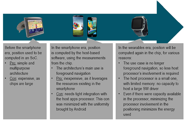
Satellite positioning embedded in devices over the last few years first saw on-chip positioning before the era of smartphones, where you had dedicated SoCs that supported the silicon used to compute the GNSS fix. These expensive chips had lots of processing power and lots of memory. Once GNSS started to be integrated into cellphones, these expensive chips did not make sense. GNSS processing could be offloaded from the expensive SoCs, and part of the GNSS processing was moved onto the smartphone application processor directly.
Since navigation is a foreground type of application, the host-based model was, and is still, a very good fit. But with advances in wearable devices, on-chip positioning will become the new architecture. This is because the host processor is small with very limited resources on wearables; and because energy must be minimized in wearables, reducing the processor involvement when computing GNSS fixes is critical.
Some vendors are taking old stand-alone chips designed for PNDs and repurposing them for wearable devices. This approach is not efficient, as these chips are large, expensive, and use a lot of power.
GNSS Accuracy
While the new fitness and background applications in wearables have forced changes in GNSS chips’ hardware and software architectures, GNSS accuracy cannot be compromised. Customers are used to the accuracy of GNSS; there’s no going backwards in performance in exchange for lower power consumption.
Figure 1. Software architecture for wearables.
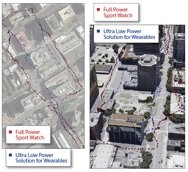
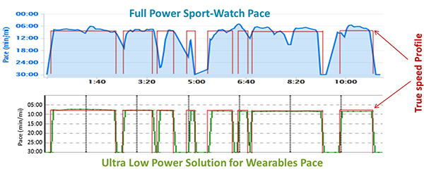
A series of tests shown here demonstrate how a new wearable, ultra-low-power GNSS chip produces a comparable GNSS track to existing devices using repurposed full-power sportwatch chips, while using only a fraction of the power.
Speed Accuracy. Not only does the ultra-low-power solution produce a comparable GNSS track, it actually outperforms existing solutions when it comes to speed and distance, thanks to close integration with sensors and dynamic power saving features (Figures 2 and 3).
Figure 2. Ultra-low-power versus full power.Figure 3. Full-power sportwatch, left, and ultra-low power chip, right, in more accuracy testing.
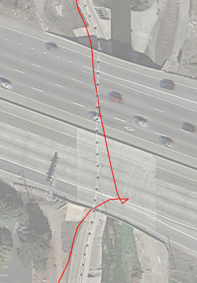
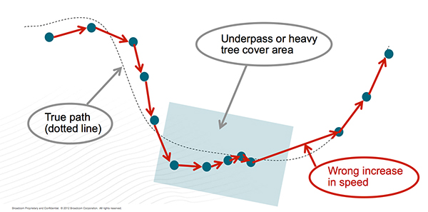
GNSS Reacquisition. GNSS-only wearable devices face a design challenge: to provide complete coverage and to avoid outliers. This is seen most clearly when the user runs or walks under an overpass (Figure 4). Familiar to urban joggers everywhere, the underpass allows the user to cross a busy road without needing to check for traffic, but requires the GNSS to reacquire the signals on the tunnel exit. See the GNSS track in Figure 5: when the device reacquires the signals, the position and speed accuracy suffers.
Figure 4. Position accuracy on reacquisition, emerging from overpass.Figure 5. GNSS speed accuracy on reacquisition.
Using the filtered GNSS and sensors, however (Figure 6), enables smooth tracking of speed and distance through the disturbance.
Figure 6. Sensors provide smooth speed estimate.
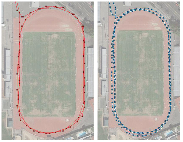
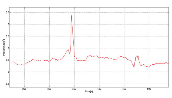
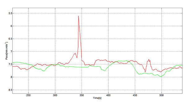
Urban Multipath. The pace analysis in Figure 7 shows a user instructed to run at a constant 8-minute/mile pace, stopping to cross the street where necessary. The red line on each plot shows the true pace profile. The commercial GNSS-only sportwatch on top shows frequent multipath artifacts, missing some of the stops and, worse for a runner, incorrectly showing erroneously high pace. The ultra-low-power chip captures all the stops and shows a constant running pace when not stopped.
Figure 7. Urban multipath tests.
It is well known in the community that regular sportwatches give unreliable speed and distance estimates in urban environments — where most organized running races are held! There’s nothing worse, as a runner, than to hear the distance beep from your watch going off earlier than expected: how demoralizing! The major benefit of this solution is that the speed estimate is much more reliable in the presence of multipath. At the same time, battery life can be extended because the GNSS is configured to use significantly less power.
fSpeed in existing solutions is computed in two different ways: indirectly from two consecutive, time-stamped GNSS position estimates, each derived from range measurements to the satellites, and directly from the Doppler frequency offset measurements to the satellites. Both range and frequency measurements are subject to significant error when the direct path to the satellite is blocked and a reflection is acquired.
The effects of multipath mean that the range error may in typical urban environments be hundreds of meters. The frequency error is also a function of the local geometry and is typically constrained by the magnitude of the user’s horizontal speed.
In either case, the GNSS device alone, in the presence of signal multipath, generates a velocity vector that fluctuates significantly, especially when there is a change in the satellites used or signal propagation path between the two consecutive positions. A variety of real-life cases generate this sudden fluctuation in velocity vector:
Running along a street in an urban canyon and turning a 90-degree corner.
Running along a pedestrian lane and taking a short road underpass.
Running under tree cover and suddenly arriving at an open area.
Running under an elevated highway and turning 90 degrees to a wide-open area.
In each case, the chips are using a certain set of satellites, and suddenly other, higher signal-strength satellites become available. A typical situation is for the position to be lagging the true position (while under tree cover, going through an underpass) and needing to catch up with the true position when arriving to the wide-open area. A jump in position is inevitable in that situation. This is not too bad for the GNSS track, but it will mean a noticeable peak in the speed values that is not accurate. Fitness applications save all of the computed speed values and generate a report for each workout. These reports are not accurate, especially the maximum speed values, for the reasons explained above.
Figure 8 describes a typical situation where the actual speed of the runner is approximately constant. GNSS fixes are computed regularly; however, the speed computed from subsequent GNSS fixes have sudden peaks that spoil the workout speed reports.
Figure 8. Sudden peaks spoil workout speed reports.
The new ultra-low-power solutions for wearables solve this problem by deriving speed and accumulated distance from the sensors running in the device. This avoids incorrect speed peaks, while still being responsive to true pace changes by the runner.
In running biomechanics, runners increase pace by increasing step cadence and/or increasing step length. Both methods depend on the runner’s training condition, technique, biomechanics, and so on. As a general rule, both step cadence and step length increase as the running speed increases from a jogging speed to a 1,500-meter race speed.
A runner may use one mechanism more than the other, depending on the moment or on the slope (uphill or downhill). In the case of male runners, the ratio of step length to height at a jogging speed is ~60 percent.The ratio of step length to height in a 1,500 meter race speed is ~100 percent. For female runners, the respective ratios are ~55 percent and ~90 percent.
The ultra-low-power chips take into account both mechanisms to derive the speed values. The sensor algorithms count the number of steps every time interval and translates the number of steps into distance multiplying by the step length. The reaction time of the GNSS chip to speed changes based on a higher cadence is immediate.
Speed changes due to longer steps are also measured by the ultra-low-power chips. The step length is constantly calibrated by the GNSS fixes when the estimated GNSS position error is low. The reaction time of the GNSS chip to speed changes based on longer steps has some delay, as it depends on the estimated error of the GNSS fixes.
Manufacturer
The ultra-low-power, high-accuracy, 40-nanometer single-die BCM4771 chip was designed by Broadcom Corporation. It is now being manufactured in production volumes and is focused on the wearables and IoT markets.It consumes five times less power than conventional GNSS chips (~10 mW) and needs 30 KBytes of memory in the MCU for the software driver. It features tight integration with the accelerometer and innovative GNSS tracking techniques for extremely accurate speed, accumulated distance, and GNSS tracking data.
Steve Malkos is an associate director of program management in the GPS Business Unit at Broadcom, responsible for defining GPS sensor hub and indoor positioning features. He has a B.S. in computer science from Purdue University, and currently holds eight patents,10 more pending, in location.
Manuel del Castillo is an associate director of marketing for Broadcom in the GNSS group. He has an MS in electronic engineering from the Polytechnic Universityand an MBA from the Instituto de Empresa, both in Madrid, Spain. He holds three patents in location with five more pending.
Steve Mole is a manager of software engineering for Broadcom in the GNSS group. He received his bachelor’s degree in physics and astrophysics from the University of Manchester.
A new Placecast poll indicates that nearly 118 million smartphone owners will be relying on their phones for holiday shopping this year. For smartphone owners who plan to do holiday shopping, three out of four will use their phones to find sales, comparison shop, take pictures of possible gifts, and make purchases.
The survey also showed that American shoppers are very aware of in-store beacons, despite the fact that it is a relatively new technology; more than half (52 percent) of the cell phone/smartphone owners surveyed said they have heard of in-store beacons, and 15 percent have engaged with them.
“Brands that embrace beacons are highly likely to see a spike in their sales in the coming shopping season and in general,” said Placecast CEO Alistair Goodman.
Beacon technology is only one indoor location technology being pursued by retailers. Kevin Dennehy’s Wireless LBS Insider column from August, Indoor Location Has Major Growing Pains, but Big Upside, provides an overview.
Conducted in October among more than 2,000 U.S. adults, this was the fifth survey in Placecast’s Alert Shopper series, one of the longest running research series around how consumers interact with various marketing and purchasing mechanisms. This year’s poll reveals the latest trends in mobile shopping and provides key insights for brands and technology providers on how to connect with the highly connected consumer this holiday season, when stakes are high. The poll was conducted online within the U.S. for Placecast by Harris Poll.
According to the National Retail Federation (NRF), holiday spending will be up nearly 5 percent this year compared to last year, with the average person expected to spend about $800. The NRF reports that gift givers “plan to splurge” for holidays like Christmas, Kwanzaa, and Hanukah: “Consumers are spending more across the board on family, friends, co-workers, pets and even babysitters…Sales and discounts were listed as the most important factor.”
“It’s not surprising that consumers are most influenced by sales and discounts; the question is, what is the best way to get these offers to them? Our survey looked at various ways brand can reach customers, and we found that reaching users on mobile while they are near stores, and using in-store technology — like beacons — are some of the best ways of reaching consumers who are looking for offers, or for more information to make a purchase,” said Goodman.
Beacons are a small, low-cost piece of hardware installed in stores. They emit a signal (called Bluetooth low energy, or BLE) that can be targeted directly to phones. Beacons can bring the analytics and targeting capabilities of the online experience to physical stores — for example, sending a discount for perfume to a 40-year-old woman who has recently done an online search for scents.
Because beacon technology is relatively new, the high awareness level discovered in this wave of the Alert Shopper series may seem surprising to the industry; the research team involved in data analysis for the Harris Nielsen poll explains the possible cause: “Consumers are clearly voting in favor of beacons due to stores promoting them and the value they deliver in couponing. While awareness seems high at 52 percent, this may be due to people wanting to identify with the coolness of new technologies, and certainly indicates huge promise for it. Minority Report is looking more and more like a reality than a movie,” said Kathryn Koegel, chief of Insights and Communications Steampunkt Collaborative.
Goodman seconds this “halo effect” of new tech: “There could very well be a huge halo effect here, but nonetheless, one fact remains: we are all now assuming that there is technology in stores that can connect with our phones — whether it’s opening an app or getting a push notification. But the real art lies in delivering timely and useful ads and offers, not overwhelming the consumer, and making sure the promotions are targeted accurately.”
The Alert Shopper V survey revealed that 15 percent of cell phone/smartphone owners had interacted with beacons. “Though this number is likely higher than the actual number of people who have interacted with in-store beacons, the fact that people are highly aware of them and think they interact with them bodes well for the technology,” said Koegel.
The importance of in-store marketing was underscored by another data point from the Placecast survey; the top activity for Mobile Millennial females (women 18-34 who own a smartphone and plan on doing any holiday shopping this year) — when asked what they plan to use their smartphone for while holiday shopping this season — is searching for a coupon for a store they are already in, with over half (52 percent) looking to save money by checking their phones. The same percentage said they would use their smartphone to take a picture of a potential gift to text a friend or family member for their opinion (52 percent).
The Alert Shopper Survey #5 revealed these key takeaways for brands and marketers this holiday season:
Phones are an integral part of the shopping process: among those who plan on doing any holiday shopping, 3 out of 4 smartphone owners plan to use their phones for some part of their gift-finding and buying experience.
Among all smartphone owners, searching for an item in a search engine to find a local retailer topped the list of mobile actions for holiday shopping this season, with 2 out of 5 (39 percent) saying they plan to use their smartphone for this; sending a picture of a potential gift to a friend or family member at a close second (38 percent), followed by searching for a coupon for the store they’re in (33 percent).
Mobile Millennials are the most active mobile shoppers this holiday season: Young men ages 18-34 (91 percent) and women ages 18-34 (85 percent) who own smartphones reported the highest percentages when asked if they plan to use their phones while shopping this holiday season; these Millennials make up about 25 percent of the United States population, outpacing Baby Boomers and Gen X (ages 28-38). Though they have not reached their peak spending potential, Millennials nonetheless control 21 percent of consumer discretionary purchases, which is estimated at over a trillion dollars in direct buying power and a huge influence on purchases by older generations (i.e., parents and grandparents).
Moms and dads with children under 18 in their household will be very active on mobile: 86 percent of dads plan to use their smartphones for holiday shopping this year. When asked what they will use their phones for the most popular answer among dads was “use my phone to look for an item in a search engine to find a local retailer.” Over half (54 percent) gave this answer. Three out of four (75 percent) mothers plan on using their smartphones for holiday shopping this year. While men are searching for retail locations, mobile moms selected “take pictures of potential gifts to text and get opinions from friends/family” as the top mobile activity, with nearly half (48 percent) saying they will do this.
Satellite navigation has been at the forefront of technological developments. GPS, the most efficient and widely used satellite navigation system, is in the process of being upgraded by the technologically advanced satellites called GPS III. Once manufactured only by the U.S., satellite navigation systems are now being developed by other countries as well.
The IRNSS in India, Compass (BeiDou) in China, and Galileo in Europe are examples of systems that are either operational or are expected to be so in the next few years. These navigation systems are expected to create new opportunities in the GPS/GNSS market. The new navigation systems will require receivers’ and applications compatible with the new systems.
Although, Galileo is interoperable with GPS, it still would require new receivers and applications to complement the new system. China’s BeiDou is already partially in operation, and is expected to become fully operational by 2020. Countries such as Sri Lanka and Thailand are buying the system from China. The expansion in the use of the Chinese navigation system during the period 2015-2020 will involve military spending on COMPASS receivers both in the domestic market as well as the international market.
Topics covered include:
Introduction
Executive Summary
Global Military GPS/GNSS Market Size and Drivers
Industry Trends, Recent Developments and Challenges
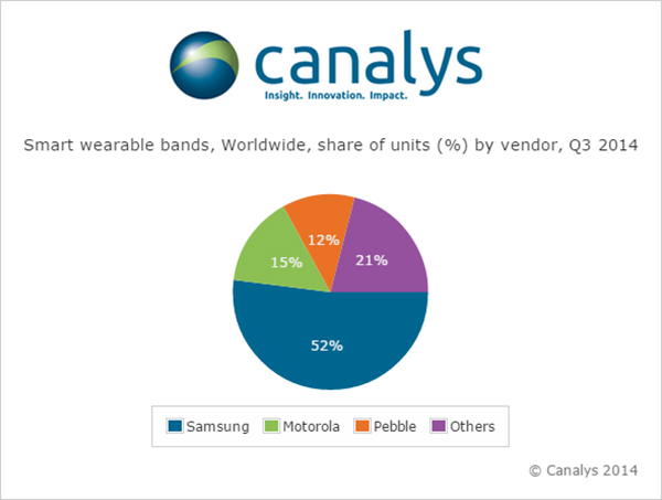
Nearly 5 million smart and basic wearable bands shipped in Q3 2014, with total unit shipments increasing 37% quarter on quarter as Android Wear made its mark for the first time, according to a report by independent analyst company Canalys.
Motorola Mobility’s Moto 360 was by far the most successful of the initial Android Wear devices, accounting for more than 15% of the smart band market according to Canalys estimates. Despite being supply-constrained, its appealing design helped it to easily out-ship other Android Wear products.
LG has responded to early interest in the Moto 360 by quickly adopting a circular display with the G Watch R.
Meanwhile, Samsung remained the overall smart band market leader, and the company has already begun to experiment with larger display sizes and cellular connectivity with the Gear S, its sixth smart band.
Though the platform is still young, Android Wear will be fundamental to the development of the market, as it is poised to be one of the two dominant wearable operating systems outside of China, alongside Apple’s Watch OS. But Google will need to redesign the Android Wear user interface before the platform can achieve its true potential.
‘The announcement of the Apple Watch late in the quarter has likely had an effect on sales of existing devices, as some consumers will choose to wait for Apple’s wearable,’ said Canalys Analyst Daniel Matte. ‘The smart band market was flat between Q2 and Q3, but with an installed base of over 1.8 billion Android smart phones, there is a huge potential market of Android users not considering an Apple Watch.”
Fitbit and Jawbone held onto their first and second place positions, respectively, in the basic band market for the quarter, and both have just announced new products. Garmin passed Nike to take third place in shipments, while Xiaomi and Huawei also overtook the one-time market leader and rounded out the top five. “Low-end basic bands providing simple activity tracking functionality are becoming increasingly commoditized, and will flood the market heading into the holidays, especially in China,” said Canalys Analyst Jingwen Wang. ‘To combat this, Fitbit, Jawbone and others have attempted to make basic bands smarter, adding various smart watch features and increasing the sophistication and integration of sensors.’
Google Fit, Microsoft Health and the Samsung Digital Health Platform have all recently been announced in response to Apple’s HealthKit. While the new Microsoft Band does not have strong hardware appeal, Microsoft’s cross-platform cloud services approach is a wise strategy, and the company is importantly staking its relevance early in a new market. There is tremendous opportunity for brand new services on wearable platforms, and not just in the area of health and fitness. Expect developers to eagerly embrace Apple’s WatchKit SDK, expected to be released in early 2015.
Wearable band shipment data is taken from Canalys’ Wearable Technology Analysis service, which provides quarterly market tracking, including country-level estimates. Canalys defines basic wearable bands as devices serving a specific set of purposes that act as accessories to smart devices, are designed to be worn on the body and not carried, and that cannot run third-party computing applications. Smart wearable bands are multi-purpose devices that serve as accessories to smart devices, are designed to be worn on the body and not carried, and are capable of running third-party computing applications. Bands are wearables designed to be wrapped around the body and do not include activity trackers in the form of clips.
The National Geodetic Survey is seeking applicants for a geodesist (real-time kinematic network) with the Spatial Reference System Division. Applications are being accepted through December 4.
The individual selected for this position will:
Serve as subject matter expert and liaison to the Real-Time Kinematic Network (RTN) community.
Assist in defining policy and guidance related to RTN for geodetic products and services.
Serve as customer service representative responding to inquiries from various users regarding the geodetic products and services related to OPUS and RTN’s.
Perform software maintenance, development, testing, debugging, and refining NGS software to improve NGS Online Positioning User Service (OPUS) Products and Services for use in validating RTN base stations.
Space News is reporting that the U.S. government has alerted the European Union that any preferential treatment the EU gives to its Galileo positioning, navigation and timing network will likely violate World Trade Organization (WTO) agreements signed by the United States and the 28-nation EU.
According to a report by Peter B. de Selding, U.S. government officials voiced concerns that the EU is weighing equipment mandates for aviation, car-accident reporting and emergency-call regulations that could unfairly tip the scales in favor of Galileo to the detriment of U.S. GPS-enabled hardware.
In a presentation to the 9th Meeting of the International Committee on GNSS, held Nov. 10-14 in Prague, a senior GPS official said the United States and the EU have signed a wide body of satellite navigation agreements designed to promote open market access and interoperability.
European Commission officials have said in recent months that they are still weighing how to stimulate Galileo use.
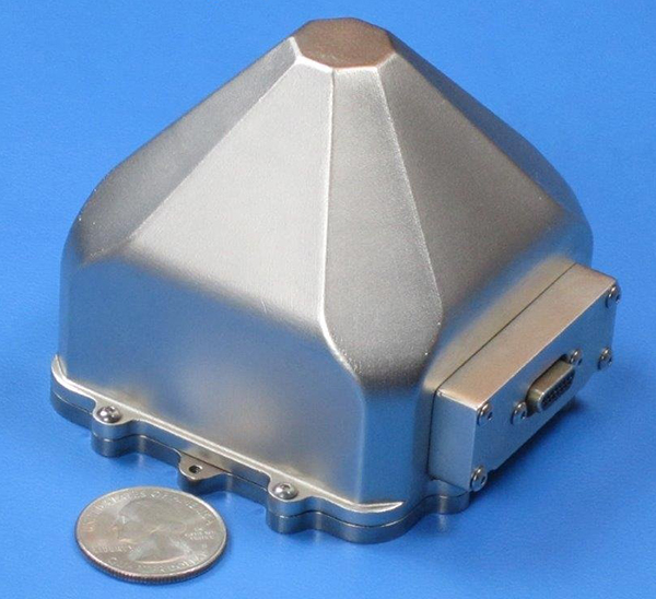
Sensors in Motion (SIM) has introduced a MEMS (micro-electro-mechanical) navigation-grade inertial system (INS) that it says could transform the $8 billion/year inertial market with new products by offering price and performance specifications better than those currently available.
The first INS devices have been delivered to the Army CERDEC Night Vision Electronic Sensors Directorate (NVESD).
SIM, a spinout from NASA’s Jet Propulsion Laboratory and California Institute of Technology, is developing a family of high-accuracy MEMS gyroscopes, accelerometers and inertial measurement unit ( IMU) solutions. It says it has perfected unique MEMS structures using volume silicon wafer processing techniques to produce gyroscopes having ARW (angle random walk) less than 0.0035 degree/root-hour and bias instability less than 0.01 degree/hour with extraordinary vibration and temperature immunity, a performance comparable to ring laser (RLG) and fiber optic (FOG) gyros that are 20 times larger and 100 times more expensive.
These features are mandatory for numerous applications where location is not available from GPS or vehicle position accuracy is required including autonomous vehicles, drones, mining asset tracking, dead reckoning, agricultural seed placement, oil and gas directional drilling, self-driving autos, firefighter navigation, optical image stabilization, industrial equipment azimuth, aerospace and defense products and most GPS-denied environments, in addition to new applications.
Current devices would have a vehicle position off as much as 1 foot per second at 45 miles per hour.
“We see this technology opening an additional $2B sensor market needing size, weight, power, cost and performance that does not exist today. “ said David Smukowski, CEO of SIM.
With adequate resources the company says further performance gains are possible, even while shrinking the devices smaller for better economics.
CSR plc has released significant upgrades for the SiRFstarV 5ea automotive-grade quad-GNSS location platform. Support has been added for concurrent use of GPS and BeiDou (BDS) satellite constellations, along with major updates to the SiRFDRive software dead-reckoning algorithms. Together, these upgrades ensure that SiRFstarV 5ea offers improved automotive positioning performance meeting the requirements of OEMs across the globe.
CSR is being acquired by Qualcomm, with the transaction expected to close by the end of the summer of 2015.
By adding support for China’s BDS constellation to SiRFstarV 5ea’s existing GPS and GLONASS capabilities, the new software offers automotive OEMs the flexibility to perform concurrent GPS and GLONASS or GPS and BDS operations. The new BDS capability provides OEMs the opportunity to market their products to regions where BDS support is mandated and also exploit the benefits of the BDS satellite constellation which is now fully operational over China and surrounding countries. The SiRFstarV 5ea platform, which is optimized and certified for the strict requirements and life cycles of the automotive industry, is also Galileo-ready through future software upgrades.
“Automotive OEMs from around the globe all have something to gain from the new additions to our cutting-edge SiRFstarV 5ea automotive location platform,” Anthony Murray, senior vice president, Business Group, at CSR, said. “Tier Ones and OEMs are looking to develop global platforms that can be easily configured to meet regional requirements and preferences, while Asian car manufacturers in particular have been calling for simultaneous GPS and BDS support to meet regional market needs for BDS support.”
SiRFDRive for SiRFstarV 5ea now also includes CSR’s latest dead reckoning algorithms that work alongside concurrent GPS and GLONASS operations. The combination of increased satellite visibility and the latest dead-reckoning algorithms improves the overall performance in challenging environments such as Chicago and Tokyo by a factor of two.
“Many Tier Ones are looking for more complete dead reckoning solutions to simplify the design process and accelerate time to market. SiRFDRive is a state-of-the-art plug-and-play solution that covers a range of end products spanning from low to high end telematics and navigation systems,” continued Murray.
SiRFstarV 5ea is designed for automotive market AEC-Q100 qualification requirements as a standalone location engine platform. The platform provides automotive Tier One suppliers and OEMs around the world with continuous, highly accurate positioning capabilities for the next generation of in-dash navigation and telematics applications in cars, trucks and other moveable assets requiring automotive-qualified devices.
Updated SiRFstarV 5ea evaluation kits are available now, and the SiRFstarV 5ea platform is ready for immediate integration into next generation infotainment and telematics products.
CSR provides the following video describing SiRFDrive.
Jerker Hellström, founder and CEO of Handheld Group.
Jerker Hellström, founder and CEO of Handheld Group, has identified three key trends in mobile computing in 2015. Handheld is a maker of rugged computers for professionals.
His predictions:
1.Larger displays even for rugged mobile computers.
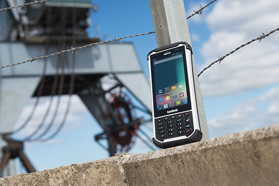
“Rugged laptops, tablets, PDAs and smartphones continue to be the fastest growing market mobile computer segment, and just like the screen size of smartphones for the mass market has increased, so will the displays of rugged computers. Screen size is the “$64,000 question” in the rugged computer segment — it is a major consideration for all users, but it is also linked to the application and how data and information are presented, both in terms of how it is captured and how it is communicated to the end user. I foresee a stronger demand for maximum screen real-estate in the smallest, lightest possible form factor. (One real-life example would be the recently launched Nautiz X8 by Handheld with a huge 4.7-inch display for an IP67-rated rugged device).”
2.Higher IP ratings.
“Mobile computers across all market segments are increasingly being manufactured, and marketed, as more durable, more rugged and with higher IP ratings (ingress protection against water and dust).This a function of computers, tablets and smartphones being with us all the time, everywhere. The consumers demand durable devices that can be knocked around a bit! But it has also become a marketing gimmick. Some devices are now advertized as having the previously unattainable IP68 rating. But do the customers actually understand it? It actually means nothing unless the manufacturer informs us of the submerged time and depth. I expect a continued upwards ‘IP rating creep’ but also an invigorating discussion about the definition and value of IP ratings and the tests carried out on mobile computers.”
3.Increasing interest for Android.
“Microsoft Windows Mobile or Windows Embedded has for a long time been the operative system of choice for rugged mobile devices, albeit with increasingly stronger competition from Android. 2015 will be the year when he industry truly embraces Android. The rapid growing of Android consumer phones has standardized the Android user behavior and generated a spillover effect to the industrial sector. There is an increase of industrial software being developed for Android, boosted by the first generation industrial Android devices. Also, Android can take advantage of powerful multicore CPUs in a way Windows Embedded Handheld has not been able to.“
The Nautix X8 rugged Android handheld.
Jerker Hellström is the founder and CEO of Handheld, a manufacturer of rugged mobile computers, PDAs and smartphones.Heis a pioneer and industry veteran in the mobile rugged computer industry. In both entrepreneurial and managerial positions, he has more than 25 years of experience from developing, designing, manufacturing and marketing rugged computers globally. Jerker´s educational background is in engineering and computer science.
Telefónica and Geotab have announced an agreement to partner in Europe. The agreement will initially focus on the markets of Spain, Germany and the U.K., with the intention to explore Latin American markets in the near future.
The solution, which includes Geotab’s plug-and-play device, offers real time fleet management and the ability to develop a number of alerts, notifications, and review driver trip and activity reports. Advanced features also include on-board diagnostics through engine indicators to return feedback, such as engine failures, or an in-depth engine fault code diagnosis; detect accidents and retrace cause of the accident; and allow add-ons such as a navigational device, NFC driver ID key, sensors and more.
According to Geotab, the technology will help businesses improve their on-road productivity, on-road safety, and ecological efficiency, in addition to optimizing fleet performance to reduce fuel costs. Fleet managers will gain more intelligence across multiple vehicles giving them the data and insights needed to make more informed business decisions in real-time. Furthermore, drivers will have more insight over their individual vehicles.
Through this agreement, Telefónica extends its fleet management offer to further cover the global needs for its clients of both large corporations and small and medium size companies.
“We’re delighted to partner with Geotab, who through continuous innovation have many of the world’s largest fleets already using their product,” said Surya Mendonça the m2m managing director at Telefonica. “This agreement allows Telefónica to provide a best-in-class ‘plug and play’ fleet telematics product in Europe that reinforces our portfolio and gives our m2m customers further access to the strongest solutions.”
“We are seeing tremendous growth for fleet management solutions worldwide and the wireless carriers are now becoming an integral component of the fleet telematics and connected machine ecosystem. We are impressed by the Telefonica m2mteam and look forward to working together with Telefonica to deliver the most advanced fleet telematics solution in the market,” said Neil Cawse, CEO of Geotab.