Author: GPS World Staff

  • The System: GLONASS in April, What Went Wrong

    The System: GLONASS in April, What Went Wrong

    By Gerhard Beutler, Rolf Dach, Urs Hugentobler, Oliver Montenbruck, Georg Weber, and Elmar Brockmann

    What Happened: On April 1, 2014, at 21:15 UTC, all GLONASS satellites started to transmit wrong Broadcast Messages (BM) as previously reported by GPS World. The satellite positions derived from these BM were wrong by up to ± 200 kilometers in each of the three coordinates x, y, and z of the Earth-fixed, geocentric, equatorial coordinate system. The problem disappeared after an hour (after two erroneous BM) for two GLONASS satellites; for other satellites, the problem lasted much longer: up to 10 hours. By about 07:30 UTC on April 2, the April Fools’  “joke” was over.

    Effect on GPS/GLONASS Receivers

    Essentially, we can distinguish two classes of receivers: those using the GLONASS BM for tracking and those not using them. The first class of receivers “became aware” of problems in real time, because GPS and GLONASS observations did not result in a consistent position estimation. In the best case, all affected GLONASS observations were flagged (and removed from further consideration) and the positioning worked properly with a reduced number of satellites. In the worst case, the receivers stopped tracking GPS and GLONASS satellites completely. The second class of receivers tracked GPS and GLONASS normally. The tracking problems created a major uproar in the user community of combined GPS and GLONASS receivers.

    On June 3, 2014, at the 13th meeting of the U.S. National Space-based Positioning, Navigation, and Timing (PNT) Advisory Board, Gerhard Beutler, representing the authors of this article, delivered a presentation including an example of a permanent network of GPS and GLONASS dual-system receivers in Switzerland and neighboring countries, where about 40 percent of the approximately 60 receivers stopped tracking both GLONASS and GPS satellites. The malfunctioning receivers had to be reset manually on the morning of April 2 (for more information, see: www.gps.gov/governance/advisory/meetings/2014-06/beutler1.pdf).

    Event as Viewed by the IGS

    At first sight, the GLONASS April 1 and 2 event was actually a non-event for the International GNSS Service (IGS). The IGS is a voluntary federation of more than 200 worldwide agencies that pool resources and data from about 400 permanent GPS and GLONASS stations to generate precise GPS and GLONASS products.

    The IGS product series, including precise GPS and GLONASS ephemerides, were generated as usual before, during, and after the event.  On April 4, a quick analysis by Urs Hugentobler revealed that only the GLONASS BM were affected; the GLONASS code (pseudorange) and phase observations and the GLONASS satellite clock corrections, were not affected.

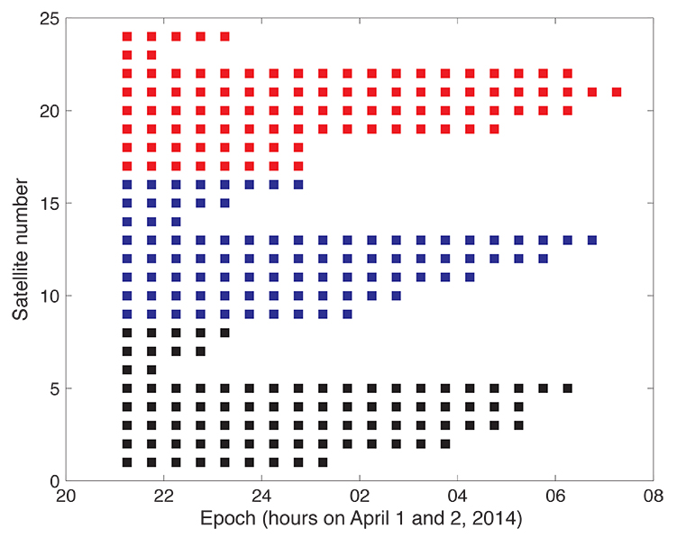
    Figure 1 shows that the GLONASS event started simultaneously for all satellites (for stationary receivers, the first wrong positions were calculated for 21:00 UTC, based on the BM with Time of Clock (ToC) at 21:15 UTC). The problem was fixed for the first two satellites (the GLONASS satellites in orbital slots 6 and 23) one hour later; the last satellite wasn’t fixed until 07:30 on April 2 (using the correct BM at 07:45).

    Figure 1. Affected broadcast messages for each GLONASS satellite. Colors indicate the different orbit planes.
    Figure 1. Affected broadcast messages for each GLONASS satellite. Colors indicate the different orbit planes.

    More than 60 percent of the more than 200 combined GPS and GLONASS receivers in the IGS network tracked the GLONASS satellites normally. Fewer than 40 percent of the combined-constellation receivers had serious data outages (for GLONASS or even for both GLONASS and GPS). The number of GLONASS observations used in the daily work of the IGS analysis centers (ACs) was, however, only reduced by about 10 percent on April 2 (and even to a lesser extent on April 1). The small reduction is explained by the fact that only the last three and the first seven hours of April 1 and 2, respectively, were affected.

    As the IGS ACs do not need the BM (neither for GPS nor for GLONASS), but may rather use their predicted orbits derived from the precise ephemerides of the preceding days, the number of good observations was still amply sufficient to calculate precise GLONASS orbits for April 1 and 2, essentially at the expected accuracy level.

    Detailed Analysis

    To further explore the structure of the problem, the BM-derived satellite positions were used as pseudo-observations in an orbit determination process. Orbit determination was successful when analyzing only “good” positions (prior to April 1, 21:00 or after April 2, 07:30). Orbit determination was successful, as well, when using only positions from “bad” BM. Successful means that the root-mean-square (RMS) error of the orbit determination process was of the order of about 0.5 meters per satellite coordinate — the expected order of magnitude.

    As the bad satellite positions are now known to obey the laws of orbital motion, one may further investigate the nature of the differences between the “good” and the “bad” orbital positions. For that purpose, the precise GLONASS orbits of the IGS Center for Orbit Determination in Europe Analysis Center served as a reference. Its orbital positions were compared in the inertial coordinate system (one not rotating with the Earth) to the erroneous BM-derived positions by means of an orthogonal transformation, where only the three rotation angles around the x-, y-, and z-axes of the inertial equatorial coordinate system were estimated.

    Table 1 shows that the positions derived from the normal (“good”) GLONASS BM compare very well to the IGS precise orbits. Except for a minor rotation about the z-axis, one obtains zero-rotations about the orthogonal axes in the inertial coordinate system.

    Table 1. Rotation of the entire system of good orbit positions (April 1, 0:00 – 20:45 UTC) with respect to precise IGS reference orbits (“good” BM) and rotation of the entire system of bad orbit positions (April 1, 21:00 – April 2, 07:00 UTC) with respect to precise IGS reference orbits (“bad” BM).
    Table 1. Rotation of the entire system of good orbit positions (April 1, 0:00 – 20:45 UTC) with respect to precise IGS reference orbits (“good” BM) and rotation of the entire system of bad orbit positions (April 1, 21:00 – April 2, 07:00 UTC) with respect to precise IGS reference orbits (“bad” BM).

    Table 1 also shows that the “bad” positions were obtained from the reference positions by a rotation of about 0.5 degrees around the inertial x-axis. The RMS of 71 meters should be compared to the entire effect of up to 200 kilometers per coordinate. Comparing this RMS of 71 meters with the RMS of the orbit determination of about 0.5 meters per coordinate also says, however, that the “true” transformation is more complicated than one represented by just a series of three rotations.

    We did not further investigate how this more or less consistent rotation could enter into the GLONASS BM. It seems to be clear, however, that a systematic error slipped into the realization of the GLONASS BM, which were activated at a common reference epoch for all satellites (but uploaded to individual satellites at different times).

    Figure 1 suggests that the problem was almost immediately recognized by GLONASS operators: already an hour later the first two satellites started to transmit BM with the usual accuracy level.

    Figure 1 also supports the idea that the problem was remedied satellite-by-satellite. A back-of-the envelope calculation revealed that the satellites were above the horizon of at least one of the Russian uplink sites at the times of switching back to the correct BM.

    Summary and Conclusions

    The GLONASS event was one that we might have described by the phrase “such a thing can never happen.” For the user community, the situation was aggravated by the fact that the event was not reported through the official Russian channel by issuing a Notice Advisory to GLONASS Users (NAGU). This definitely should have happened in the interest of transparency.

    The above analysis was based on information available through the IGS. It was performed weeks after the event. It is worth noting, however, that the information needed for the analysis was available in real time. The reference orbit used in the analyses could have been replaced by the IGS predicted orbits generated in the ultra-rapid series.

    In view of the importance of BM for all users and in particular for the users of IGS real-time products, the IGS might consider monitoring the quality of BM for all GNSS.

    Fixing the GLONASS Bug: Report from Moscow

    In a May 23 conversation with journalists, Javad Ashjaee, president of JAVAD GNSS, decried the recent controversy about monitoring stations on both U.S. and Russian soil, saying it was based in misinformation and misinterpretations, inflated by a political crisis. He also supplied a different perspective on the GLONASS signal outage than has been reported in other media outlets.

    “There was speculation in early April that it took GLONASS 11 hours to correct a software bug because it took that long for all the satellites to pass over a control station on Russian soil. This was not the case, I have learned from conversations with their engineers and with the head person responsible for all of this. One engineer made a mistake and uploaded the wrong software. Until they could find it and debug it — and it took them 11 hours to do so — they could not upload correct software to the satellites.

    “The 11-hour outage was not due to a wait for all satellites to pass over ground control stations on Russian soil to receive a fresh upload of data,” continued Ashjaee. “GLONASS has the capability, like GPS, to make updates via inter-satellite communication. The delay was caused by the time it took to find the bug in the erroneous software that had been uploaded and correct it.”

    Ashjaee addressed the monitoring station controversy, saying that Russia had sought GLONASS monitoring stations in the United States, not for uploading any data, but for monitoring GLONASS satellites to provide more accurate orbit and clock information, for the free benefit of all users.

    Click here for Ashjaee’s full discussion of the U.S.–Russian monitoring station controversy. For news updates on the situation, see http://stage.globalpositioningnews.com/tag/russian-monitoring-stations/.
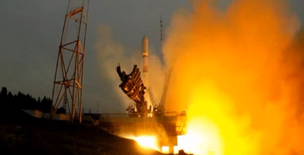
    Russian Launch

    A single GLONASS-M satellite was launched from the Plesetsk Cosmodrome on June 14. GLONASS-M 55 (with designation 755 once operational and also known as Kosmos 2500), was inserted into the constellation’s Plane 3 and will occupy orbital slot 21.

    Manufacturer Reshetnev reported that the satellite is equipped with an experimental payload capable of transmitting signals in the L3 frequency band. The L3 signal, centered at 1202.025 MHz , is CDMA unlike the GLONASS legacy FDMA signals. The experiment will include flight testing of the new equipment and evaluation of its accuracy characteristics. The GLONASS-K1 test satellite also transmits an L3 signal.

    GLONASS-launch-O

    European Space Symposium: Digest

    Copernicus, “the younger brother of Galileo,” will be the main implementation of Galileo and other GNSS technologies going forward in Europe, according to to Paul Weissenberg, EC deputy director general for enterprise and industry. An Earth-observation satellite program administered by the European Space Agency to provide accurate and timely information to improve the management of the environment, understand and mitigate the effects of climate change, and ensure civil security, Copernicus was previously known as the Global Monitoring for Environment and Security (GMES).

    Sliding to the Right. Galileo will make its “early-service declaration in the first half of next year,” said Matthias Patschke, director of EU satnav programs. This appears to back off slightly from previous dogged determination to declare services before the end of 2014.

    The EC may propose legislation to make mandatory the use of GNSS technology in different areas: as with eCall, starting in 2015, including Galileo in the receivers inside cars, according to Marian-Jean Marinescu, member of the European Parliament.

    Peter Large of Trimble spoke out against the mandating of a specific GNSS use in any market: “A bad policy outcome that moves backward into regionalization.”

    For an expanded report, see the June GNSS Design & Test e-newsletter.

  • Tests Show Existing Tech Can Meet Proposed FCC Indoor 911 Accuracy

    fcc-logo_TAn independent study of indoor tests of a hybrid wireless location technology was submitted today to the Federal Communications Commission (FCC) by wireless location engineering firm TechnoCom. The study demonstrates that existing technologies can satisfy location requirements within the timeframe proposed by the FCC in its draft rule on indoor 911 accuracy for wireless calls, according to True Position, which commissioned TechnoCom to perform the testing.

    Multiple wireless carriers have challenged the technical feasibility of the proposed rule, claiming that existing technologies cannot satisfy the proposed accuracy requirements, with a spokesperson for the industry trade association claiming the rule represented “aspirational target setting.”

    The results filed today by TechnoCom disprove those assertions, showing that viable technology exists in the market today, True Position said.  According to TechnoCom’s findings, “The outcome is a current overall performance that readily meets the FCC’s proposed location performance threshold for indoor wireless E911 at the 67th percentile.  The demonstrated performance even comes very close to meeting the 50 meter threshold at 80%, which is intended for 5 years from adoption of the proposed rules.”

    Multiple other vendors have submitted filings to the FCC claiming that their technologies would also satisfy the requirements of the rule on the timeline proposed by the FCC.

    “These results should prove helpful to the FCC as it moves toward reaching a resolution on its proposed rule on indoor location requirements,” said Craig Waggy, CEO of True Position.  “We know that accurate location information is vitally important to American consumers, and that the FCC is intent on remedying the lack of wireless indoor location requirements for calls placed to 911 from wireless devices.”

    The tests were conducted using True Position’s commercially available Uplink Time Difference of Arrival (UTDOA) technology standalone, and a hybrid solution consisting of Assisted GPS (A-GPS) and UTDOA technologies, and included indoor testing in both urban and suburban environments in Wilmington, Delaware, and surrounding areas.

    For the testing, buildings of varying sizes, construction materials and use were selected by the independent firm, and a total of 62 test points were selected among 16 buildings. In all cases, the test buildings and test points remained anonymous to True Position until the conclusion of the testing and delivery of all results to the independent firm.

    In early 2013, TechnoCom conducted the indoor accuracy testing for the FCC’s Communications, Security, Reliability and Interoperability Council (CSRIC).  The same location and measurement methodologies were used in these tests.

    The FCC has estimated that 10,000 lives could be saved each year if calls made to 911 from wireless phones had accurate location information.

  • ABI Research: Third Generation of LBS to Capitalize on Location-Based Advertising

    The LBS market continues to grow strongly and with the arrival of always-on ubiquitous location, ABI Research believes that the market is ready to truly support location based advertising efforts. In Western Markets, a third generation of location-based services is now underway. It has forecast retail/shopping, ambient intelligence, hyperlocal social and personal asset tracking/BLE beacon applications to emerge as the next wave of important location based services over the next five years, with ABI Research forecasting a four-fold increase in revenues by 2019.

    In emerging regions the value of location is not lost with strong local deals/offers markets already emerging. Senior analyst Patrick Connolly comments, “In Asia, ABI Research sees LBS downloads breaking 4 Billion in 2019. In China, major Internet companies can see the necessity of location and are acquiring/integrating as they move to mobile. Tencent, the Chinese Internet giant, has spent approximately $200 million to acquire an 11.28% stake in mapping company NavInfo. This follows Alibaba’s acquisition of AutoNavi. Tencent has also invested in the Chinese Yelp, Dianping, which is one of the top three players in the local deals market, which is estimated to have reached $1.2 Billion in 1Q14. Sina Weibo, which floated on the NASDAQ in April also has its own Places application.”

    Furthermore, in a reversal of previous LBS application trends, ABI Research expects to see many of these companies expanding into international markets in the future. Momo is such an app, with 20 million subscribers, which is using location to go local and generate advertising revenues. It has used a round of investment to launch an English version of the application, which it hopes will enable it to expand.

    These findings are part of ABI Research’s Location Based Services Market Research.

  • New Geospatial Computing Book Penned by Ruizhi Chen

    Geospatial-computing-WA new text and reference book, Geospatial Computing in Mobile Devices, has been published by Artech House. Recent developments in smartphones enable them to meet many of the demanding requirements for geospatial computing, in terms of computation power, data storage capacity, and memory space. This book, written by Ruizhi Chen and Robert E. Guinness, addresses and instructs in geospatial data acquisition, processing, visualization, context detection, and context intelligence.

    Chapters of the 209-page book include:

    • Fundamentals of Mobile Positioning
    • GNSS, Wireless, and Hybrid Positioning in Mobile Devices (three separate chapters)
    • Mobile GIS and LBSs (two separate chapters)
    • Context Awareness and Reasoning (two chapters), and
    • Future Directions in Mobile Geospatial Computing.

    Co-author Ruizhi Chen previously published a cover story in GPS World magazine, 3D Smartphone Navigation Using Geocoded Images and another technical article, Multi-Sensor, Multi-Network Positioning, also in GPS World. He is a professor and head of the Department of Navigation and Positioning at the Finnish Geodetic Institute. He holds a Ph.D. in geophysics from University of Helsinki. He is the general chair of the IEEE conferences Ubiquitous Positioning, Indoor Navigation and Location-Based Services held in 2010 and 2012, and scheduled this year for November 20–21 at Texas A&M University, Corpus Christi.

  • ESA Recognizes First Galileo Navigation Fixes

    ESA Recognizes First Galileo Navigation Fixes

    ESA offered to issue certificates for the  first 50 Galileo positioning fixes — provoking responses from across the whole world. While half the applications came from Galileo’s home continent, others came from the rest of the world, including Australia, Canada, China, Egypt, New Zealand, Russia, United States, and Vietnam.
    ESA offered to issue certificates for the first 50 Galileo positioning fixes — provoking responses from across the whole world. While half the applications came from Galileo’s home continent, others came from the rest of the world, including Australia, Canada, China, Egypt, New Zealand, Russia, United States, and Vietnam.

    Billions of satnav position fixes are performed daily, but determining your place in the world using Europe’s Galileo system is quite new. Because of this, in March the European Space Agency (ESA) offered to issue certificates for the first 50 Galileo fixes.

    Responses to the offer came from around the world. While half the applications came from Galileo’s home continent, others came from Australia, Canada, China, Egypt, New Zealand, Russia, the United States, and Vietnam.

    The first two satellites of Europe’s Galileo constellation were launched in October 2011, followed by two more a year later. Four is the minimum needed for determining position, allowing testing of the full Galileo system to begin.

    Slovakian company GoSpace performed Galileo positioning while driving around Bratislava on 1 May 2014. The company was among those certified by ESA for their early Galileo positioning achievement.
    Slovakian company GoSpace performed Galileo positioning while driving around Bratislava on 1 May 2014. The company was among those certified by ESA for their early Galileo positioning achievement.

    The historic first positioning fix using only Europe’s civil-owned navigation system took place at ESA’s Navigation Laboratory in its ESTEC technical centre in Noordwijk, the Netherlands, on March 12, 2013.

    Galileo’s navigation signals could be picked up anywhere in the world that the orbiting satellites come into view, however. Equipped teams from industry, universities, research centers, and government institutions took the opportunity to perform their own fixes, along with a couple of private individuals.

    The Galileo team knew of fixes being performed on an informal basis. The idea came to mark the anniversary of the first positioning fix by issuing commemorative certificates to groups who had picked up the signals to perform their own fixes. Teams were asked to include details of the receiver they used, the start and finish of the fixes in Universal Time Coordinated (UTC) and a plot of their latitude/longitude positioning overlaid on a map, such as Google Earth.

    • Italy turned out to be the single best-represented country in Europe, with six separate fixes,
    • Germany and the UK followed Italy closely with five fixes each.
    • Several groups achieved fixes on the very same day as ESA.
    •     Figure 1. Positions obtained by only Galileo E1 Open Service (the antenna is located at the roof of the Ta Quang Buu library building inside HUST campus)
      Galileo positioning performed in the NAVIS Centre at the Hanoi University of Science and Technology in Vietnam on March 27, 2013, overlaid on a Google Earth map.

      Most of the receivers were software-based radio systems, with signal processing performed by software on a computer linked to a radio-frequency front end. Professional receivers were also customized.

    • A private individual from Gdansk, Poland, used his own receiver to perform a fix, intended for amateur rocketry.
    • An individual in Pec, Hungary, achieved a fix with a modified receiver.
    • Most of the applications were obtained with static receivers and simple position fixes with Galileo’s Open Service signals, but there were some special cases. These included precise point positioning, where offline processing is applied to give extremely precise centimeter-scale positioning — typically used in surveying, the oil and gas industries, and precision agriculture. Some of these fixes were actually performed before the first real-time positioning fixes, including fixes done at the University of New Brunswick.
    • Belgium’s Royal Military Academy performed Galileo’s first position fix at sea, aboard Belgian frigate Leopold-I, which sailed along the Norwegian coast.
    • A navigation company from New Zealand performed positioning while walking.
    • A technology firm in Slovakia performed drive testing.
    • A German telecom company made use of the satellite signals for timing and network synchronization. One of the most important applications of Galileo will be as a nanosecond-scale time source, enabling the effective synching of financial, power and data networks around the globe.
    A Trimble Navigation team used one of their own handheld receivers to perform Galileo-based positioning in pedestrian testing in Christchurch, New Zealand on 14 April 2014. The results are overlaid on a Google Earth map. 
    A Trimble Navigation team used one of their own handheld receivers to perform Galileo-based positioning in pedestrian testing in Christchurch, New Zealand on 14 April 2014. The results are overlaid on a Google Earth map.

    The certificates will be issued soon.

    General use of Galileo will begin as more satellites join the first four in orbit so the first services can be rolled out. The next two Galileo satellites are in French Guiana, beginning their preparations for launch.

    It should take only a slight software update to ready the current generations of satnav receivers to work with Galileo signals, ESA said.

    Sources of Galileo certification applications.
    Sources of Galileo certification applications.
  • Letters: Galileo Sync, GLONASS Scoop, an Open Letter

    GPS_May_enews_160June Cover Story

    In the June issue’s cover story, “Interchangeability Accomplished,” is a paragraph headed, “Satellite Intersystem Biases,” which appears to assert that Galileo System Time (GST) is 3 seconds ahead of UTC.

    However, in the version of the Galileo Signal In Space Interface Control Document posted at: http://ec.europa.eu/enterprise/policies/satnav/galileo/files/galileo-os-sis-icd-issue1-revision1_en.pdf, paragraph 5.1.2 appears to indicate that Galileo System Time (GST) was synchronized, at the second level, with GPS time on 22 August 1999 (that is, 13 seconds ahead of UTC).  And, given that a) GST, like GPS time, does not step for announced leap seconds, and b) the IERS has, as of today, announced 3 leap seconds since 22 August 1999, such would appear to suggest that GST is presently roughly 16 seconds (vice 3 seconds) ahead of UTC.

    — Stuart Eventhal
    Fountain, Colorado

    Author Frank van Diggelen replies:

    Yes! You are right, the article should have said 16 seconds for Galileo, not 3. Thanks for catching that. I’ve corrected the text that appears in the online version of the article, and the accompanying figure.

    Media Scoop

    The online article covering Javad Ashjaee’s input on the GLONASS situation makes a positive statement that clarifies what has been a horrible reporting job across the board by news channels.

    Fox, CBS, NBC, and ABC should all be ashamed that GPS World scooped them on what appears to be a simple story.

    Good work.

    — Mark Silver
    IGage Mapping Corporation
    Salt Lake City, Utah

    To Consumer-Grade GNSS Chip Manufacturers

    I would like you to consider including a very simple feature in your GPS functionality that will permit elevation to be identified to decimeter level in many instances. The changes needed to the chip are simply the ability to accept an accurate latitude and longitude input, and an elevation calculation function that uses input latitude and longitude.

    In addition to enabling instantaneous calculation of an accurate elevation, it may be that a “residual better accuracy” will remain for some time after the calculation, and that this will permit substantially improved latitude and longitude identification at a close distance.

    The geo-location scene has evolved rapidly over the past 20 years. It is now very commonplace to be able to locate the latitude and longitude of a location extremely quickly and extremely accurately. For instance, the Google Earth image from the front of my house shows the dotted dividing line in the center of the road. Measuring one of these lines in Google Earth gives a size of 3.1 meters by 20 to 30 cm wide. The lines actually measure 3.0 meters by 12 cm wide. From within Google Earth I can identify the latitude and longitude of the end point on the centre of this line to within ±10 cm with a high degree of confidence. In addition there may be some other small errors in Google’s reporting of the latitude & longitude (for example due to placement of the image or distortion of the image), but these are hopefully minimal.

    Now if I place my GPS unit on the end center of this line in the road, I am provided with a result that I know is erroneous. The GPS horizontal location shown in Google Earth is very rarely within two meters of my known location. It is known that altitudinal accuracy is always some two times worse than horizontal accuracy.

    If I can simply tell the GPS unit that I am at this known horizontal location, it is a relatively simple calculation to recalibrate the clock and pseudoranges to provide my elevation, which will have an accuracy of a two times the accuracy of the horizontal position. Decimeter horizontal accuracy will provide 2-decimeter altitude accuracy. This is close to 100 times better than the elevation accuracy currently available on any consumer grade stand-alone device and is also effectively instantaneous!

    This functionality is simple to implement. I would hope that it could be implemented with nothing more than an upgraded ROM which includes a new API function to allow the input of “I know this is my current horizontal location” and an enhanced calculation process which uses this horizontal location to calculate altitude.

    I am unsure whether a residual improvement in accuracy can be attained. Even an improved accuracy for 1 minute after the fix would be useful in many situations, and an improved accuracy for 5 to 10 minutes would be a boon.

    — Glenn Thorpe
    Holder, Australia

  • M3 Systems Announces Simulator Based on Vector Signal Transceiver

    M3 Systems Announces Simulator Based on Vector Signal Transceiver

    StellaNGC_Simulator-O

    M3 Systems is now offering the StellaNGC multi-constellation GNSS simulator based on the National Instruments (NI) vector signal transceiver.

    The simulator is designed for the testing of satellite navigation receivers for GPS, GLONASS, Galileo, and EGNOS/WAAS. It is designed to improve performance, scalability, and versatility, and reduce cost over existing navigation test solutions.

    GNSS is the predominant technology today for navigation and outdoor positioning. However, given the weakness of GNSS signals, receiver performance is often affected by interference from the local environment and propagation channel conditions. Understanding the effects of this interference is of particular importance not only for existing GNSS signals but also for future signals that will appear with the deployment of new constellations such as Galileo.

    To properly characterize receiver performance under varying conditions, the StellaGNC multi-constellation GNSS simulator provides signal generation, signal recording and replay, interference generation, signal and data processing, and complete analysis tools. The StellaNGC simulator is based on the NI vector signal transceiver in PXI for improved performance and full simulation capabilities. For record and playback only, a scaled-down version is also available based on the NI USRP (Universal Software Radio Peripheral). Both options were developed with NI LabVIEW and benefit from the performance and flexibility of the NI RF platform.

    The simulator provides a scalable solution that allows easy signal additions through software upgrades, multi-frequency, processing extensions with the addition of FPGAs with NI FlexRIO, and an HDD extension for storage increase. Because the simulator is based on the open PXI standard, the hardware investment can also be extended to other applications, such as simulation, record and playback, or payload simulation.


  • EuroGeographics to Create Expert Group in GNSS Positioning

    Members of EuroGeographics are creating a European platform for networking, sharing best practices, and exchanging expertise on GNSS positioning.

    Plans for the new Positioning Knowledge Exchange Network (KEN) were revealed at the association’s recent Extraordinary General Assembly following a proposal by the Head Office for Geodesy and Cartography, Poland. Its focus will include:

    • maintaining a network of experts in satellite positioning and navigation
    • following the development of relevant technologies and practices
    • working on the most effective utilization of Galileo services, and
    • developing common standards, policies and guidelines for best practice.

    Now EuroGeographics members will work to agree on roles and joint actions through a cooperation agreement with the European Position Determination System (EUPOS), the Reference Frame Sub Committee for Europe (Euref), and the Council of European Geodetic Surveyors (CLGE). The new Positioning KEN will incorporate experts from all four organizations and will also invite other key players to participate.

    “This is a really exciting addition to our range of benefits for members,” said EuroGeographics Executive Director and Secretary General Dave Lovell OBE. “It demonstrates how they are driving the association’s development to ensure its activities continue to meet their needs by reflecting emerging trends and the relevant interests of the European Institutions. We look forward to strengthening our relationships with EUPOS, Euref and CLGE as we work together to create the uniform GNSS service for Europe.”

    EuroGeographics KENs provide an open forum for members and invited experts. Each focuses on an area of particular interest for national mapping, land registry and cadastral authorities. These include Business Interoperability, Quality and Emergency Mapping.

  • FCC to Fine Chinese Jammer Retailer $34.9M for Online U.S. Sales

    FCC to Fine Chinese Jammer Retailer $34.9M for Online U.S. Sales

    GPS_Jammer

    The Federal Communications Commission plans to issue the largest fine in its history against C.T.S. Technology Co., Limited, a Chinese electronics manufacturer and online retailer, for allegedly marketing 285 models of signal jamming devices to U.S. consumers for more than two years.

    The FCC applied the maximum fine allowed to each jammer model allegedly marketed by C.T.S., resulting in a planned fine of $34,912,500.

    “All companies, whether domestic or foreign, are banned from marketing illegal jammers in the U.S.,” said Travis LeBlanc, Acting Chief of the Enforcement Bureau. “Signal jammers present a direct danger to public safety, potentially blocking the communications of first responders. Operating a jammer is also illegal, and consumers who do so face significant civil and criminal penalties.”

    GPS_jammer_CTS-T2C.T.S. operates a website that markets consumer electronics to individuals in the United States, where it allegedly misled U.S. consumers by falsely claiming that certain signal jammers were approved by the FCC. In fact, the use of such devices by U.S. consumers is illegal under any circumstance. C.T.S. also sold 10 high-powered signal jammers to undercover FCC personnel.

    The FCC also is ordering C.T.S. to cease marketing illegal signal jammers to U.S. consumers and provide information to the FCC about any persons and entities in the United Sates that purchased its devices.

    Signal jammers are radio frequency transmitters that intentionally block, jam, or interfere with authorized communications, such as cellphone calls, GPS systems, Wi-Fi networks, and first responder communications. It is a violation of federal law to market, sell, import, or use a signal jammer in the United States and its territories, except in very limited circumstances involving federal law enforcement.

    The FCC is asking people to report the sale or use of an illegal jammer by contacting the FCC Enforcement Bureau through the FCC online complaint portal, or by calling 1-888-CALL-FCC (or 1-888-225-5322). To voluntarily relinquish a signal jammer, e-mail [email protected]. Additional information, including the FCC Consumer Alert on the jamming prohibitions and the FCC Enforcement Advisory to retailers regarding the marketing of illegal signal jammers, is available at www.fcc.gov/jammers.

    The FCC enforcement action against C.T.S. is available at http://hraunfoss.fcc.gov/edocs_public/attachmatch/FCC-14-92A1.pdf.

  • Rugged IP68 GPS Handhelds and Field Computers Launched

    Rugged IP68 GPS Handhelds and Field Computers Launched

    The GAGAN-enabled Sxtreo GN11.
    The GAGAN-enabled SXtreo GN11.

    Stesalit today announced the availability of the SXtreo range of rugged GPS handhelds for survey, industrial use, and field work under extreme conditions such as agriculture, forestry, roads, security and construction.

    The SXtreo series of mobile devices are rated IP-68, meaning they are waterproof, dust proof, shockproof, and are coupled with built-in mobile GIS applications. Long battery life allows GPS data collection for a full work day, without the need for recharging. The GNSS devices come with full-size USB port for connecting devices.

    Stesalit is based in India, and the SXtreo gives that country an affordable option to take geotagged photos and conduct waypoint surveys. The design and conceptualization of SXtreo is a result of the in-house R&D effort of Stesalit. The road towards the birth of SXtreo is presented in the video:

    The GAGAN-enabled SXtreo GN series of rugged GNSS field computers and PDAs comes with a full keypad and large five-inch sunlight-readable screen for field data entry in large forms. These models are designed for GPS data collection and asset management, socioeconomic surveys, mapping, agriculture, logistics, forestry, public transportation, construction and security.

    The SXtreo WP 60 and WP61 devices have all the features of a smartphone.

    The Sxtreo WP 61 rugged smartphone.
    The SXtreo WP 61 rugged smartphone.

    SXtreo handheld’s Android and embedded Linux-based open-source secured operating systems are compatible with a range of sector-specific applications designed by Stesalit.

    • SXgeo is specially designed for waypoint, routes, and track surveys. The added advantage from the similar existing applications is that one can capture geotagged photos and transfer the survey data through GPRS.
    • SXsurvey is a complete suite for comprehensive survey management. With the features of SXgeo, one can also create large forms dynamically in the devices for survey data collection.
    • SXfield is specifically built for the field workers and employees working away from office like road construction, oil, gas and other utility services, logistics and distribution chains, FMCG, consumer and white good companies with large sales networks, operations and maintenance organizations with large service networks, and security organizations including police.
    • The integrated application SXagro is a geospatial agriculture decision-support system in use by agriculture universities and state agriculture departments.

    In addition, the SXtreo range of IP68 rugged smartphones is compatible with most of the off-the-shelf mobile software applications.

  • KVH Launches TACNAV 3D Inertial Nav System with Embedded GPS/GNSS

    KVH Launches TACNAV 3D Inertial Nav System with Embedded GPS/GNSS

    TACNAV-3D-KVH-O

    KVH Industries has introduced TACNAV 3D, a highly accurate inertial navigation system designed for battlefield vehicles, at Eurosatory 2014, an international defense and security industry trade show in Paris, France.

    The TACNAV 3D system is the latest product in KVH’s TACNAV line of tactical navigation systems, and will be on display in the KVH booth (Stand J531, Hall 6) at Eurosatory through June 20.

    The fiber-optic gyro-based TACNAV 3D inertial navigation system provides full three-dimensional navigation and an embedded GNSS. Its modular tactical design and flexible architecture allow it to function as either a standalone inertial navigation solution or as the core of an expandable, multi-functional battlefield management system. It is designed to provide navigation for light armored vehicles, both wheeled and tracked, medium and heavy combat vehicles, and main battle tanks.

    The TACNAV 3D system is fitted with an Iridium transceiver to transmit and receive vehicle position, waypoint, and target location to or from a command center or other vehicles, and can receive messages from the battlefield management system to pass on to the command center via the Iridium short duration burst message function. TACNAV 3D can also receive and transmit Ethernet and CANbus signals, and RS-422.

    “For military vehicles operating on the modern digital battlefield, this completely modular package is a vital component for effective battlefield management,” said Dan Conway, KVH executive vice president for Guidance & Stabilization sales. “It is affordable, lightweight, and easy to integrate with any number of existing vehicles, both turreted and non-turreted. With a built-in communications option, TACNAV 3D is designed for short duration burst messaging, which can make a life or death difference to a soldier.”

    TACNAV 3D builds upon the success of KVH’s TACNAV family of products, and incorporates the 1750 IMU, which combines 3 axes of KVH’s compact high accuracy DSP-1750 fiber optic gyro (FOG), with three axes of high-performance MEMS accelerometers. The TACNAV 3D system is designed to provide extremely accurate heading, dead reckoning, navigation, orientation, and 100% situational awareness in GNSS-denied environments.

  • Arrow RF & Power Reaches Agreement with Maxtena

    Arrow Electronics, Inc., has announced that its RF & Power business will globally distribute products from Maxtena, Inc., a developer and producer for wireless solutions, including GNSS, Iridium, Inmarsat and Thuraya satellites, and terrestrial M2M, MSS and LTE applications.

    Arrow RF & Power will distribute Maxtena’s line of rugged and compact helix antennas, microstrip antennas, and combo antennas, and will also support customers with custom wireless solutions ranging from smart metering to 4G LTE. Maxtena’s products are designed for portable wireless applications including satellite phones, communications gear, handheld navigation, asset tracking, UAVs, recreational devices, and industrial equipment.

    “Maxtena’s proprietary Helicore technology provides high-performing yet miniaturized antenna solutions,” said Mark Vitellaro, director, strategic marketing, Arrow RF & Power. “Maxtena’s technical and competitive advantages combined with our technical and customer support will enable design engineers to utilize the optimum antenna solution for their needs.”

    “Maxtena is very excited to have Arrow RF & Power on board as an authorized distribution partner,” stated Vanja Maric, director of sales and marketing, Maxtena. “Their product and technology knowledge and expertise, along with their ability to form strong and lasting customer relationships make Arrow RF & Power a perfect fit for Maxtena and our unique products.”

    More information is available at www.arrow.com/rfpower.