Tallysman Wireless, Inc., is offering a family of very low power, compact, high-performance GNSS antennas for precision, commercial, and military applications.
Based in Ottawa, Canada, Tallysman Wireless, is a designer and manufacturer of high-performance GNSS, Iridium, and Globalstar antennas and associated components.
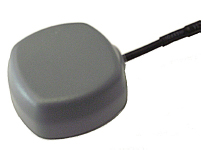
The TW4327 and TW4329 are low-power GPS L1 + GLONASS G1 antennas that feature current consumption of 1.75 mA typically and parametrically invariant performance over a supply range from 2.5V to 12V.
The TW4327 o ffers a 21-dB gain minimum, and the TW4329 includes a narrow pre-fi lter to prevent front end saturation by near out-of-band interfering signals.
Both antennas are more tolerant to detuning eff ects caused by the operational environment, thanks to a 40% thicker patch element that provides wider bandwidth than conventional antennas. These antennas are also very compact (38mm x 38mm x 14.4mm), making them ideal for use in a wide range of locations.
The TW4027 and TW4029 are equivalent antennas for reception of GPS L1 signals.
“These products are ideal for any battery operated applications where low power is a pre-requisite,” said Gyles
Panther CEO of Tallysman Wireless, “and the wider patch element bandwidth will minimize detuning in non-ideal
environments, such as in covert applications.”
Tallysman Wireless has recently added an authorized distributor of its products for Russia (Aurora Mobile Technologies), and another distributor for Asia (Advanced Information Technology, Inc.), for the countries of Vietnam, Hong Kong, Singapore, China, Indonesia, and India.
The two April failures in Russia’s GLONASS were caused by mathematical mistakes in software, according to Oleg Ostapenko, head of the Russian space agency Roscosmos.
Russian newspaper Ria Novosti reported on a press conference where Ostapenko said that programmers who had designed the satellites’ new software had made several mathematical mistakes, but the problem was not major and has practically been solved. “There were some mathematical mistakes, but they have been corrected,” he said.
Ostapenko said that the remaining problems would be solved by mid-May, and there is almost no chance of a similar failure happening in the future.
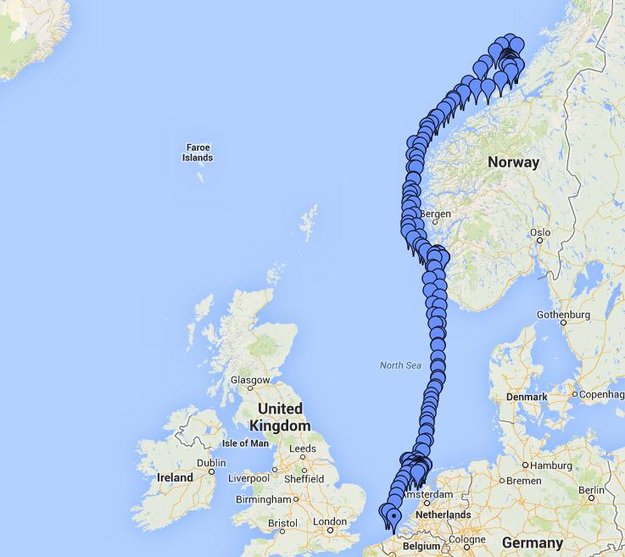
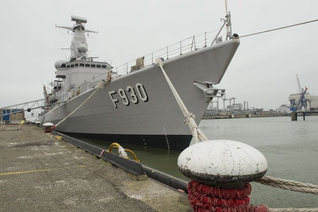
Belgian frigate Leopold I-F930 in rough water off Norway during Galileo maritime testing. In December 2013 the frigate participated in the first maritime trials outside mainland Europe of the Galileo satellite navigation system.
Results are being processed from the first Galileo maritime trials outside of mainland Europe. The long-range, high-latitude testing spanned the North Sea, following the same historical sailing route that Viking dragon-ships used 1200 years ago.
Ancient manuscripts record Viking navigators relied on “sunstones” to find their way — archaeologists believe these may have been polarizing crystals to pinpoint the Sun even in overcast skies.
By contrast, Belgian frigate Leopold I-F930, participating in the end-of-year trials, carried the most up-to-date equipment possible, with multiple Galileo receivers for both its public Open Service (OS) and secure Public Regulated Service (PRS).
“Galileo is in a transition between its In-Orbit Validation (IOV) phase and follow-on Full Operational Capability phase,” said Miguel Manteiga Bautista, head of ESA’s GNSS Security Office. “This means we are engaging in all kinds of experimental demonstrations of all Galileo services, in particular PRS, which offers the most highly accurate positioning and timing performance, but with access strictly restricted to authorized users.”
The recorded course of Belgian frigate Leopold I-F930 during the first high-latitude trials of Europe’s Galileo satellite navigation system. The frigate sailed first from the Dutch marine base of Den Helder on 4 December 2013 to Stavanger in Norway. From there it progressed north in very rough seas with 10-m high waves, coming close to the Arctic circle on December 17 — a first for Galileo PRS observations — before heading homeward.
The frigate sailed first from the Dutch marine base of Den Helder on December 4, 2013, to Stavanger in Norway. From there it progressed north in very rough seas with 10-meter-high waves, coming close to the Arctic circle on December 17 — a first for Galileo PRS observations — before heading home.
The testing provided tangible in-situ evidence of Galileo signal stability across both its operating frequencies up at high latitudes, equaling low satellite elevations in the local sky.
Following the completion of earlier road, then flight, testing last summer and autumn, the last challenge for Galileo’s IOV phase was to engage in a long-term maritime trial into high latitudes. The testing was performed as part of the PRS Participants to IOV project jointly managed by ESA and the European Commission, in collaboration with the European GNSS Office Agency and several Member States possessing PRS test receiver technology.
The trials were performed by the Royal Military Academy of the Belgian Ministry of Defence, the UK Space Agency in collaboration with Nottingham Scientific Ltd. and ESA, to ensure PRS signals were available whenever the four Galileo satellites in orbit came into view.
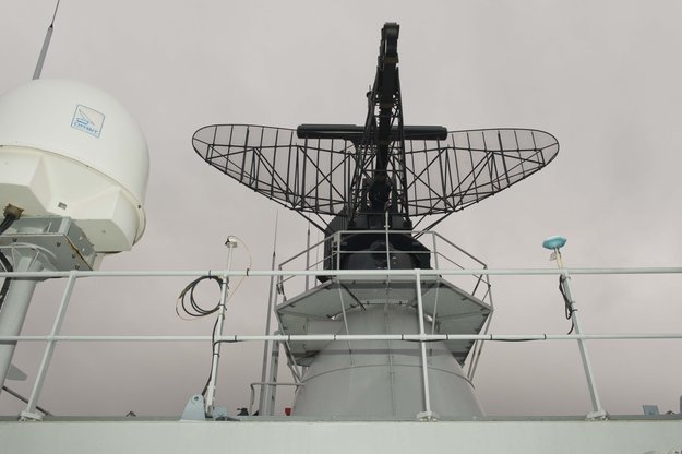
Two receivers, seen either side of the main antenna, were carried by Belgian frigate Leopold I-F930 during high-latitude testing of both Galileo’s publicly-available Open Service and secure Public Regulated Service in December 2013.
A dual-test setup was fitted to the frigate at Den Helder. Belgium connected a PRS receiver and an OS receiver, both manufactured in Belgium by Septentrio NV, to a common antenna. The PRS receiver recorded raw PRS measurements on both frequencies while the OS receiver logged data from openly available Galileo, GPS and GLONASS signals at one-second intervals.
Nottingham Scientific installed its Ultra system configured to record radio-frequency samples, allowing the detailed post-processing of Galileo OS and PRS signals.
“As this was a first use of PRS equipment outside EU borders, the security issues were quite challenging,” said Bruno Vermeire, head of the Belgium Competent PRS Authority (Federal Public Service of Foreign Affairs). “Several partners from different countries and industries were involved. At all times the necessary security was assured, though this could not have been possible without the dedicated joint commitment of all partners.”
David Parker, head of the UK Space Agency, commented, “This test is a significant milestone on the road to demonstrating early PRS capability across a range of platforms. It should serve as a model for wider international collaboration between national governments and industry to prove and demonstrate PRS in different applications.”
Belgian frigate Leopold I-F930 at Den Helder dockyard in the Netherlands.
Alain Muls, professor of the Royal Military Academy of Belgium, faced the challenge of coordinating the maritime trial without interfering with the normal operations of the frigate. “Thanks to the cooperation of with the Maritime Component of the Belgium Defence, in particular that of the frigate’s commander and crew, preliminary results look very promising. Reception of Galileo’s OS and PRS navigation services have been practically demonstrated under severe maritime conditions with waves of up to 10 meters in height.”
“This activity is a truly collaborative effort at all levels. The trial involved UK and Belgian governments and industry partners with support from different European bodies as well as officials from the Netherlands and Norway,” said Mark Dumville, Nottingham Scientific general manager. “This team effort has enabled the concept of radio-frequency sampling processing of Galileo PRS signals to be tested in real-world operational environments. We have confirmed that the prototype receiver is now ready to support European governments and associated PRS applications.”
The collaborative nature of this trial was formally recognized as the Leopold I-F930 reached Stavenger. Under the supervision of Belgium’s CPA, Jochen Devadder, the country’s Ambassador to Norway Michel Godfrind provided a Norwegian delegation with details of the testing.
Results from the trial will guide future Galileo developments for years to come.
U.S. Air Force Space Command will be implementing CNAV messages on the GPS L2C and L5 signals beginning April 28 at 14:30 UTC, to facilitate user familiarization and development of compatible user equipment. No GPS satellite outages or degradations are planned. The L2C and L5 CNAV messages should be transparent to users.
A 30-day public comment period on the pre-operational CNAV message ended April 4, apparently without enough concern to halt or delay the implementation.
These pre-operational signals may not comply with all requirements, and so shouldn’t be used for safety-of-life or other critical purposes, Air Force Space Command said.
Full text of the NANU appears below:
Subject: New NANU 2014038
NOTICE ADVISORY TO NAVSTAR USERS (NANU) 2014038 NANU TYPE: GENERAL
*** GENERAL MESSAGE TO ALL GPS USERS *** The purpose of this notification is to inform users of an upcoming event related to the GPS satellite constellation. Air Force Space Command will be implementing CNAV messages on the GPS L2C and L5 signals beginning J118/1430z with updates from the control segment approximately twice per week. The message populated signal content will include Broadcast Message Types (MT) 10, 11, 12, 30, and 33. There are no planned GPS satellite outages or degradations for this activity. L2C and L5 CNAV messages should be transparent to GPS receivers that do not process L2C or L5 CNAV messages. These populated signals are intended to facilitate user familiarization and development of compatible user equipment.
NOTE: Until further notice, the L2C and L5 signals are considered pre-operational. A pre-operational signal means the availability and other characteristics of the broadcast signal may not comply with all requirements of the relevant Interface Specifications and should be employed at the users’ own risk. Therefore these signals should not be used for safety-of-life or other critical purposes. Any military or civil users who encounter user equipment problems following message population of the L2C and L5 signals should contact the applicable POCs identified below as soon as possible. Aviation users should file reports consistent with FAA-approved procedures.
*** GENERAL MESSAGE TO ALL GPS USERS ***
POC: CIVILIAN – NAVCEN AT 703-313-5900, HTTP://WWW.NAVCEN.USCG.GOV
MILITARY – GPS OPERATIONS CENTER at HTTPS://GPS.AFSPC.AF.MIL/GPSOC, DSN 560-2541,
COMM 719-567-2541, [email protected], HTTPS://GPS.AFSPC.AF.MIL
MILITARY ALTERNATE – JOINT SPACE OPERATIONS CENTER, DSN 276-3514,
COMM 805-606-3514, [email protected]
NovAtel Inc. announces that with the release of its 6.400 firmware, NovAtel CORRECT positioning technology is now available with TerraStar’s precise point positioning (PPP) corrections. Delivered via L-band, TerraStar corrections provide decimeter-level accuracy worldwide on all NovAtel OEM6 high-precision receivers, without users having to add base-station infrastructure. Subscriptions to the TerraStar correction service are available seamlessly to customers through NovAtel’s standard sales order process.
NovAtel CORRECT optimally combines data from multiple GNSS satellite constellations with corrections from a variety of sources, to deliver the best position solution possible. The strategic importance of TerraStar’s decimetre-level correction service to NovAtel’s product offering is reflected in the recent purchase of TerraStar parent company Veripos by Hexagon.
“The OEM nature of TerraStar’s correction service makes them a perfect partner for NovAtel,” stated Sara Masterson, New Business Development Manager for NovAtel. “We are extremely pleased with the performance of our current TerraStar offering and, with the ability to now work more closely together, we are very excited about developing positioning innovations for our customers in the future.”
NovAtel CORRECT is available for land, air and sea applications, providing customers with one-stop shopping for receivers, antennas and correction services. It provides integrators with the opportunity to choose pricing and subscription options that best match their OEM business objectives.
GPS IIF-5 was launched on February 20 and turned over to the 2nd Space Operations Squadron (2 SOPS) for operations on March 5. This was the 10th successful launch and initialization using Braxton Technologies‘ Launch, Anomaly Resolution, and Disposal Operations (LADO) system.
LADO has performed all the mission planning, commanding and telemetry processing necessary to prepare all GPS satellites for operational use since October 2007. Developed and sustained by Braxton Technologies, LADO was built using Braxton’s ACE Premier commercial-off-the-shelf (COTS) product line for spacecraft control, astrodynamics and simulation.
“Braxton is proud to be a key partner on the GPS program,” said Ken O’Neil, Braxton’s President and Chief Operating Officer. “As a small business, we greatly value our partnership with the US Air Force and enjoy quickly delivering innovative capabilities to support the U.S. military and the GPS worldwide user community.”
The GPS IIF-5 replaces the GPS IIA-15 satellite launched in 1994. The 19th Space Operations Squadron (19 SOPS) will control the GPS IIA-15 using LADO, where the spacecraft will be stored as a spare available for reactivation within the x-plane for the remainder of its useful life.
Omnilink, a provider of advanced machine-to-machine (M2M) tracking and monitoring solutions, has been named to the Verizon Partner Program as a Silver member.
“U.S. government agencies, businesses, and consumers have depended on Omnilink to monitor the location, safety, and condition of offenders, assets, vehicles, loved ones, fleets, employees, and much more since 2004,” said Steve Hudson, Omnilink’s chief development officer. “We help businesses track and monitor virtually anything on almost any device, and set high standards in reliability, accuracy and ease of use. And now we are excited to make these solutions available to Verizon customers.”
Omnilink FocalPoint Offender Monitoring is an advanced electronic monitoring solution that gives government agencies the ability to reliably track and monitor the location and status of their entire offender caseload across the U.S. on virtually any device. FocalPoint Offender Monitoring combines reliable GPS/AGPS/AFLT/RF hardware, the friendliest software, comprehensive 24/7/365 support services, and state-of-the-art-infrastructure for complete offender supervision.
Omnilink Asset Tracker helps companies better manage their assets with an award-winning asset optimization, theft prevention, and monitoring and safety solution. Asset Tracker is an all-in-one asset tracking system that gives companies the ability to track and monitor the location and condition of all their physical assets—vehicles, trailers, equipment, retail, ATMs, bank bags, goods in transit, and much more — across the U.S. and beyond via their computer, tablet, and smartphone.
The Verizon Partner Program tailors regional and national opportunities for systems integrators, value added resellers, agents and solutions providers to accelerate delivery and adoption of solutions for meeting medium business requirements. In addition, the program features a tiered benefits structure that allows members the flexibility to determine levels of commitment, and also includes simple-to-use tools and clear and consistent engagement processes.
Verizon Enterprise Solutions creates global connections that generate growth, drive business innovation and move society forward. With industry-specific solutions and a full range of global wholesale offerings provided over the company’s secure mobility, cloud, strategic networking and advanced communications platforms, Verizon Enterprise Solutions helps open new opportunities around the world for innovation, investment and business transformation.
Spectra Precision has introduced the MobileMapper 20 GIS handheld. In the same form factor as the current MobileMapper 10 handheld, MobileMapper 20 offers enhanced capabilities: a new bright VGA color touch screen display, a 5-MP camera for higher resolution images, doubled memory capacity and 3.5G cellular performance.
The Spectra Precision MobileMapper 20 provides real-time GPS accuracy of better than 2 meters and post-processed accuracy of a half-meter using MobileMapper Office software. Mapping professionals can also take advantage of Spectra Precision’s optional MobileMapper Field software for data collection, maintenance and inspection.
MobileMapper 20 GIS handheld.
MobileMapper 20 incorporates a variety of communication technologies, including Bluetooth, Wi-Fi and a 3.5 G cellular modem, to keep mobile workers connected and more efficient while in the field. With a compact lightweight design, large display and long battery life (typically more than 20 hours), the easy-to-use handheld is ideal for intensive data collection. The MobileMapper 20 runs Windows Embedded Handheld 6.5 and offers the flexibility to support a broad range of third-party software applications.
“Building on the popular MobileMapper 10 handheld and responding to our customers’ evolving needs, we have significantly increased the power and functionality of our entry-level MobileMapper product portfolio,” said Olivier Casabianca, business area director of Trimble’s GeoInstruments. “With the introduction of MobileMapper 20, Spectra Precision is further extending the GIS capabilities of our customers in the field, while simultaneously providing them with the peace-of-mind of a standard two-year warranty.”
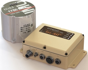
The Geo-iNAV Advanced is a fully integrated GPS-aided inertial navigation system that utilizes KVH’s 1750 IMU to provide a high-performance navigation solution.
KVH Industries, Inc., has entered into a strategic partnership with Geodetics Inc., developer of real-time, high-precision position and navigation solutions. The goal is to provide high-performance positioning and navigation products for commercial applications requiring high levels of precision, from unmanned platforms to terrestrial navigation.
Geodetics is integrating the KVH 1750 inertial measurement unit (IMU) into two solutions: Geo-iNAV Advanced, a GPS-aided inertial navigation system; and Geo-RelNAV, a high-accuracy relative navigation, positioning, and orientation system. The KVH 1750 IMU provides highly accurate 6-degrees-of-freedom angular rate and acceleration data, contributing to the high performance of the Geodetics products while also providing a commercial off-the-shelf (COTS) solution. The COTS designation means the Geo-iNAV Advanced system is available for commercial applications such as manned and unmanned aircraft and control, security platforms on land, air and sea, surface or subsea unmanned vehicles, mobile mapping systems, and photogrammetry and terrestrial navigation.
As reported April 9, NovAtel, Inc., has added the KVH 1750 as an inertial measurement unit (IMU) option in its SPAN GNSS/INS line of positioning products.
“Geodetics evaluated a number of IMU technologies, and based on our desire to address the needs of the commercial marketplace worldwide without sacrificing performance, we chose the KVH 1750 IMU, says Dr. Jeffrey Fayman, vice president, planning and development for Geodetics Inc. “With the integration of the KVH 1750 IMU in Geo-iNAV Advanced, you have the best inertial navigation system Geodetics can provide worldwide.” The navigation, position, and orientation accuracy of the Geo-iNAV Advanced is centimeter level, according to Fayman, thanks in part to the high accuracy of the KVH 1750 IMU.
“KVH is proud to have a strategic relationship with Geodetics,” says Jay Napoli, vice president, FOG/OEM sales at KVH. “The high performance of the 1750 IMU helps enable Geodetics’ systems to deliver ground-breaking accuracy while remaining available to the commercial marketplace.”
For navigation challenges such as collision avoidance and vehicle-to-vehicle navigation and communication (V2V), the Geodetics Geo-RelNAV system offers a highly accurate, real-time relative positioning and orientation solution that utilizes single- or dual-frequency GPS receivers and the high performance KVH 1750 IMU. The Geo-RelNAV provides precise relative position and orientation between moving platforms such as manned or unmanned air, marine, and ground vehicles. This relative position data is used for such applications as autonomous aerial refueling, autonomous landing, and collision avoidance.
KVH is one of the only fiber optic gyro manufacturers to control the entire production process, from creating its own specially designed polarization-maintaining optical fiber to packaging its gyros together in advanced systems for inertial measurement, inertial navigation, and attitude heading and reference systems. As a result, KVH’s inertial sensors and gyros offer outstanding accuracy and excellent durability at a lower cost than competing systems.
Spectracom, a business of the Orolia Group, has extended its global service capability through a partnership with EZU Technologies. Joining Spectracom service centers in North America and Europe, EZU Technologies will support Spectracom users throughout the Asia-Pacific region from its facility in Hong Kong. Initially, services will include equipment calibration and repair services. Over time, more capability will be added to deliver Spectracom’s full range of services in the region.
Spectracom’s portfolio of GNSS signal management solutions include a variety of services to ensure their customers gets the most out of their application for positioning, navigation and timing. “We understand our customer’s needs for fast access to services. Our strong growth in Asia, particularly for GNSS simulation and enterprise-class timing, will be supported by localizing services in the region,” said Thierry Delhomme, general manager, Spectracom Europe.
This new service center is the first of several partnerships to deliver global services in support of Spectracom solutions. Lisa Withers, Spectracom President and CEO, said, “We are pleased to expand our existing partnership with EZU Technologies to develop a regional service hub. This will enhance the local service provided by our strong set of local distributors and resell partners throughout the region.”
Spirent Communications today introduced the GSS6300M range of multi-channel GPS and multi-GNSS simulators for receiver integrators, application developers, aftercare and production testing environments. This entry-level test system readily enables laboratory evaluation of GPS performance across different locations and routes, Spirent said. In addition to being easy-to-use even for non-GPS experts, the GSS6300M range features competitive pricing for engineering teams looking to integrate positioning functionality to new classes of consumer electronic devices.
The GSS6300M is a “one-box” solution with everything required to start testing immediately and can be controlled from a tablet or smartphone, or via remote commands across multiple interfaces. It enables a variety of fundamental test and compliance to industry standard. Users can create custom trajectories using a Google Maps interface to help evaluate receiver performance.
The GSS6300M offers the same preeminent signal quality as other Spirent test systems, which are used by governments and space agencies around the world. High fidelity test equipment ensures the highest user experiences, leading to improved customer satisfaction, reduced product returns and greater market success for integrators and application teams.
“Positioning is of key importance to a wide range of new applications and consumer devices. As navigation and GPS test experts, Spirent wants to help developers build high-performing positioning functionality into their systems quickly and easily,” said John Pottle, marketing director of Spirent Positioning Technology. “Spirent provides test equipment that our customers rely on to achieve accurate results they can trust. The GSS6300M continues this tradition and is priced to be widely accessible.”
The GSS6300M is designed to for the huge and growing range of applications and technologies that incorporate location features — from vehicles and mobile devices to wearable technology, security tracking and other new market segments. In addition to GPS, the GSS6300M fully supports GLONASS, BeiDou and Galileo, the Russian, Chinese and European navigation systems.
Pitney Bowes Inc. has entered into a multi-year partnership with INRIX, Inc., provider of traffic information and driver services, to deliver advanced location intelligence solutions through the company’s traffic intelligence platform.
By integrating location capabilities with traffic analysis, INRIX and Pitney Bowes will enhance the driving experience of today’s connected drivers, the companies said. By delivering this information through INRIX’s mobile app, users are empowered to make better location-based decisions in real-time.
“Pitney Bowes’ location intelligence solutions can add compelling new capabilities to the existing products of mobile-oriented companies such as INRIX,” said James Buckley, Senior Vice President and General Manager, Location Intelligence, Pitney Bowes. “Our products help unearth non-obvious relationships between specific locations to improve the customer experience and drive loyalty.”
INRIX has designed a leading traffic intelligence platform that uses smart data and advanced analytics to solve transportation issues worldwide. The company uses a unique approach called “smart crowd-sourcing” that analyzes real-time traffic speed and incident data from a wide variety of public and private traffic sources ranging from road sensors and up-to-the-minute traffic speeds and community reports crowd-sourced from millions of vehicles and mobile devices throughout the day. Whether through an in-car or smartphone navigation application, a local newscast or the company’s INRIX Traffic app, INRIX offers up-to-the-minute traffic information and other driver services to help more than 150 million drivers save time, fuel and money.
Pitney Bowes Location Intelligence solutions merge organizational data with location data to provide users with the capability to make more informed decisions. For INRIX, this technology compiles and correlates addresses with coordinates from a mobile device to establish real-time location or a desired destination. Combining that with other data such as specific traffic flow, demographics and behavior patterns, users can uncover key points of interest by accessing Pitney Bowes advanced location search. For example, if a consumer is planning to visit a popular department store in a specific region, the technology makes it possible to suggest a relevant restaurant recommendation for lunch, based on the data that is collected about user preferences, convenience, proximity and projected traffic patterns.
“INRIX had a number of compelling reasons to partner with Pitney Bowes,” said Scott Sedlik, Vice President, Product Planning and Market Development for INRIX. “Our customers are looking to make real-time decisions using location data, and Pitney Bowes has the most comprehensive suite of offerings to fulfill that need. Other key reasons for teaming include a strong customer focus and alignment with our own strategic goals and approach.”