Author: GPS World Staff

  • Locata Warns: Lessons to Be Learned from GLONASS Spasm

    Locata Warns: Lessons to Be Learned from GLONASS Spasm

    Calling it an “unprecedented and deeply worrying total disruption . . . [that] shook the industry,” Locata Corporation reiterated its call for redundant terrestrial systems to back up GNSS in the wake of the April 1 11-hour GLONASS system outage.

    Nunzio Gambale, Locata CEO, said “We have been telling the industry for years that you cannot have a critically important capability like GPS without also having a backup! What is Plan B if the satellite systems fail? What replaces the space signal when there is a problem? If anyone needed a sign to understand why Locata has spent years inventing and developing the world’s first local terrestrial equivalent of the GPS system, then last week’s meltdown of a complete global satellite navigation system is it. This event should terrify every nation, government, and company that depends on navigation satellites for their business or, in some cases, their very lives.”

    The navigation and timing functions of the global positioning systems underpin the world’s banking systems, stock exchanges, digital TV and Internet, cell phone networks, and, in some cases, the national electricity supply, Locata pointed out. GPS, in particular, plays a crucial role in transportation, shipping, and logistics, serving as the enabling technology for critical functions like air traffic control. Reliability is therefore not just important; it is essential across all applications. Locata, the Resilient Navigation and Timing Foundation (RNTF) in Washington, D.C., and others have persistently called attention to the need for redundant terrestrial systems that will back up expensive, vulnerable, and aging global satellite navigation constellations while simultaneously providing the local control and resiliency that satellite-based systems cannot deliver.

    Professor Chris Rizos of the School of Civil and Environmental Engineering at the University of New South Wales stated that “This catastrophic failure of one of the world’s two global satellite navigation constellations is a wakeup call for all of us. We ignore the possibility of these ‘Black Swan’ events at our own peril.”

    The GLONASS disruption was felt around the world, immediately upon its origination, especially in professional applications, such as tractor automation for farming, machine control and robotics in mining and heavy industry, and in the national infrastructure used by surveyors and industry across many countries.

    “This shows just how interlinked the physical and cyber worlds have now become,” added Professor Brett Biddington, a space and cybersecurity expert from the School of Computer and Security Science at Edith Cowan University, Australia. “The prospect of a software glitch, whether unintentional or intentional, seems highly likely [as a cause for the failure]. If it was a deliberate attack, however, it points to a changing face of warfare where the real enemy may be impossible to detect and deter until very damaging strikes, such as an attack on the GPS system, have already taken place.

    “The vital point here is that this is no longer just a question for scientists and technologists. A locally controlled backup system for this essential signal is a national policy question of the highest order.”

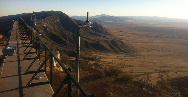
    Locata Corporation and other industry authorities have long testified on global satellite navigation vulnerabilities and the need for diverse technology options to strengthen and back up GPS, GLONASS, and other systems. Locata developed a robust solution and has been awarded a sole-source contract by the U.S. Air Force (USAF) to provide its terrestrially based alternative positioning for military applications where GPS has been completely jammed. The first wide-area Locata system is being deployed now at the White Sands Missile Range in New Mexico. The USAF demonstrated that the White Sands Locata network delivers what has been extremely high accuracy over a 2,500-square mile area, positioning aircraft flying up to 35 miles away to an accuracy of better than six inches.

    A pair of LocataLite transmit antennas overlook a section of the White Sands Missile Range blanketed by the Locata high-precision ground-based positioning system.
    A pair of LocataLite transmit antennas overlook a section of the White Sands Missile Range blanketed by the Locata high-precision ground-based positioning system.

    “There is no other technology that can do this, and it’s delivered in the complete absence of GPS,” continued Gambale. “What is being demonstrated at White Sands is that Locata supplies precisely the same function as GPS, even when there is no GPS available. That’s exactly what you need if the satellites fail.

    “If this event had been a GPS failure instead of a GLONASS failure – and it could very easily have been – then the entire world would have plunged into a catastrophe. This event is the navigation equivalent of a ‘close call moment,’ and from here on out no one can even question that this is a really serious problem that must be addressed. Another industry expert recently told me, ‘If there was a sustained GPS outage, it would cause a global financial nuclear winter from which it would take us decades to recover.’”

    Gambale concluded, “We need action to develop local backups like Locata around places like airports and other strategically important areas – now! We must not wait until we are faced with another seemingly impossible event like a complete satellite constellation failure. We may not dodge this bullet a second time.”

    Locata terrestrial positioning technologies complement GPS by setting up ground-based transmitters, called LocataLites, to create a local constellation called a LocataNet. Once properly deployed, Locata’s unique nanosecond-accurate TimeLoc system synchronizes the network, which allows it to replicate the positioning capabilities of GPS, locally. LocataNets operate today in environments ranging from small warehouses to open-cut mines, wide-area aircraft approach-and-landing systems, and wider areas for aircraft and unmanned aerial vehicle (UAV) uses.

  • Septentrio Offers Multi-Constellation Receiver for Space Weather Monitoring

    Septentrio-PolaRxSThe PolaRxS by Septentrio is a multi-frequency, multi-constellation receiver dedicated to ionospheric monitoring and space weather applications. It features simultaneous high-quality tracking of all visible signals (L1, L2, L5, E5ab/AltBOC GPS/GLONASS/Galileo/Beidou/SBAS) at low noise levels. The receiver outputs an extensive set of GNSS measurements, including signal phase and intensity at up to 100 Hz, with a phase noise standard deviation (phi60) as low as 0.03 rad.

    The A Posteriori Multipath Estimator (APME+) tackles short-delay multipath to enhance the measurement quality, while LOCK+ tracking guarantees robust tracking of rapid signal dynamics during scintillation events. Included tools provide continuous total electron content (TEC) and scintillation indices logging for space weather and ionosphere monitoring.

    Learn about more Galileo-ready products in our Galileo Product Showcase from the April 2014 issue.


  • Indoor GNSS Positioning Research Employs Spectra Precision Equipment

    Researchers at Telecom SudParis are working on a solution to provide indoor continuity for GNSS positioning. The idea is to deploy a minimal transmission infrastructure in order to allow a standard receiver to measure pseudo-ranges and carrier phases, thus leading to an indoor accurate positioning. The infrastructure consists of a few antennas fed through optical fibers with a GNSS-like signal.

    Based in Paris, Telecom SudParis is a part of the Institut Mines-Telecom, an education and research institution in the fields of information and communication technology.

    Nel Samama
    Nel Samama

    To achieve positions accurate to a few decimeters, the locations of the various indoor antennas had to be accurately known.  This was achieved with the Spectra Precision FOCUS 8 total station in a local reference frame. In addition, in order to calculate the indoor positioning in WGS84 format, to achieve full compatibility with current outdoor GPS, a Spectra Precision ProMark 800 GNSS receiver was used to link the local reference frame and the GPS.  “ The accuracies of the FOCUS 8 and the ProMark 800 and their ease of use were invaluable to us,” said Nel Samama, lead researcher and Professor at the Institut Mines-Telecom.

    The International Conference on Indoor Positioning and Indoor Navigation (IPIN) 2012 and 2013 published the first results of the research, and the latest results will soon be published in a paper, “Repealite Based Indoor Positioning System Performance.”  The papers propose a new approach to indoor positioning: the repealite system. It aims at providing continuity of the positioning service through the use of GNSS-like signals, thus leading to a single technological means: a GNSS receiver, for both outdoors and indoors. A few error sources have been dealt with in order to reach sub-meter accuracy indoors, among which one has to cite multipath and near-far effects. The paper describes a way to reach indoor sub-meter accuracy and the practical current implementation of the system.

  • LBS Market Worth $39.87 Billion by 2019

    A newly issued report by MarketsandMarkets focuses on growth in the location-based services market, and says it will be worth $39.87 billion by 2019.

    The report, “Location Based Services (LBS) Market (Mapping, Discovery and Infotainment, Location Analytics, Leisure and Social Networking, Location Based Advertising, Augmented Reality and Gaming, Tracking) — Worldwide Forecasts and Analysis (2014-2019),” provides a comprehensive market and forecast analysis of the overall market, segmented by products, services, technologies, applications, regions, and verticals. The report covers all the major sub segments of the LBS market and provides the quantitative (market size and market growth) and qualitative (trends, analysis, and insights) analysis for those segments.

    Included are 99 market data tables, 17 figures spread through 254 pages, and an in-depth table of contents on the LBS market. This comprehensive coverage of the LBS Market provides important inputs such as drivers, restraints, and opportunities in this market, profiles the major players in this market, maps the competitive landscape, and provides the overall perspective on the LBS Market in the various verticals and regions, according to MarketsandMarkets.

    LBS is a solution that stands for applications that integrate geographic locations information with business processes, helping in analysis of location information. The location-based information is required in distinct business data sets for relating, comparing, and analyzing relationships in the data. The service also provides an economical alternative to agencies with existing internal GIS resources. As a result of these multidimensional benefits of location information, operators are considering it as an asset, leading to numerous investments being made to extract, use and market it.

  • GLONASS Transitions to New Geocentric Coordinate System

    The transition to using the terrestrial geocentric coordinate system “Parametry Zemli 1990” (PZ-90.11) in operating GLONASS has been implemented, according to an April 4 announcement by the Russian Federal Space Agency’s Information-Anayltical Center.

    The implementation fulfills Russian Government Resolution № 1463 of December 28, 2012, “On the Common National Geodetic Coordinate Systems,” outlining the transition starting at 3 p.m. on December 31, 2013. The fundamental geodetic constants as well as the Earth’s ellipsoid parameters used in PZ-90.11 are provided in the annex to the resolution.

    The updated version of the GLONASS ICD (edition 5.1 of 2008) has been published.

  • SkyTraq Launches Miniature Programmable GNSS Receiver Module

    SkyTraq‘s new family of high-performance system-in-package (SiP) GNSS receiver modules supports GPS, GLONASS, Beidou, QZSS and SBAS.The modules integrate SkyTraq Venus8 positioning engine, 1MByte Flash memory, LNA, SAW filter, high precision 0.5ppm TCXO, RTC crystal, and other passive components within tiny 10mm x 10mm x 1.3mm package. The smallest configuration requires only antenna and power to have position fix and generate NMEA output.

    This new 10mm x 10m sized GNSS module family consists of Venus858F-GL GPS/GLONASS receiver module, Venus858F-BD GPS/Beidou receiver module, and Venus838F GPS receiver module. All three modules support additional QZSS and SBAS signal. The three modules are pin compatible; one application design works for all three models.

    Within the consumer and industrial GNSS segment, these modules feature industry’s fastest 50Hz GPS, 20Hz GPS/Beidou, and 20Hz GPS/GLONASS update rate, 29sec cold start TTFF, and better than -160dBm tracking sensitivity.

    Module interface includes two UART, four SPI, one 2-wire interface (I2C compliant), and two PWM among the 28 function-multiplexed digital I/O. A customized Arduino IDE can be used to program the modules, making use of the on-chip peripherals and sharing the internal 32bit RISC, IEEE-754 compliant FPU, and memory resources. Venus838F GPS module has roughly 50MIPS + 490KByte Flash + 45KByte RAM available for user programming.

    Optimized for lowest bill of material cost, the dime-sized modules are designed for high-volume cost-sensitive GNSS applications. Combined with properly tuned antenna fitted to customer’s application design, it provides optimal performance at lowest system cost.

    To lower barrier of adopting latest satellite navigation technology, the traditionally higher-priced GPS/GLONASS and GPS/Beidou receiver modules are offered at same price as the GPS receiver module.

    Volume delivery of all three modules to customers begins in May 2014; engineering sample, datasheet, reference design, and evaluation kits are available now.

  • NovAtel Adds Commercially Exportable IMU-KVH1750 to SPAN GNSS Line

    NovAtel Adds Commercially Exportable IMU-KVH1750 to SPAN GNSS Line

    NovAtel's iMU-KVH1750.
    NovAtel’s iMU-KVH1750.

    NovAtel, Inc., has added the IMU-KVH1750 as an inertial measurement unit (IMU) option in its SPAN GNSS/INS line of positioning products. The IMU-KVH1750 is a high-performance commercial off-the-shelf (COTS) sensor that offers excellent bias stability and repeatability, NovAtel said. It incorporates KVH’s DSP-1750 precision fibre-optic gyro with very low noise MEMS accelerometers.

    Commercially exportable, the IMU-KVH1750 integrates easily with NovAtel’s OEM6 series of receivers to provide a tightly coupled 3D navigation solution, the company said. Offering customers continuous position, velocity and attitude (roll, pitch and azimuth) measurements, a SPAN system is stable and available even through periods when satellite signals are blocked or unavailable.

    The IMU-KVH1750 supported SPAN system is designed for mobile and airborne mapping applications as well as hydrographic survey. It can be relied on to provide accurate, continuous performance in harsh environments, and features excellent shock vibration and thermal functionality.

  • Spectracom Offers GNSS Signal Generator for Production Testing

    Spectracom Offers GNSS Signal Generator for Production Testing

    GSG-51-GNSS-Signal-Generator-WThe GSG-51 GNSS signal generator provides a fast and cost-effective solution for production testing for Galileo and other GNSS. It emulates a single GNSS signal and can be upgraded for Galileo, as well as to increase the channel count, add receiver trajectory control, and add advanced features such as SBAS (WAAS, EGNOS,MSAS, or GAGAN), white noise generation, or multipath simulation. Its main application is a simple but very fast manufacturing test, to assure that the assembly is correct, that the antenna is properly connected, and that the receiver can receive and identify a satellite signal, for instance, in mobile phones with integrated GNSS receivers.

    With a wide RF level range from –65 to –160 dBm, the sensitivity of all types of GNSS receivers can be verified with a minimum of delay. The 60-dB of extra power from normal test scenarios allows for splitting the signal many times.

    Contact Spectracom to learn more.

    For more products ready for Galileo, see our Galileo Product Showcase.

  • IRNSS-1B Launched into Orbit

    India’s Indian Space Research Organisation (ISRO) launched its second navigation satellite today, April 4, at 11:44 UTC. A Polar Satellite Launch Vehicle (PSLV) rocket launched the IRNSS-1B spacecraft in a mission originating from the Satish Dhawan Space Centre. Read more here.

  • Second of Seven Satellites for IRNSS Launched

    Second of Seven Satellites for IRNSS Launched

    IRNSS-B is launched April 4, 2014.
    IRNSS-B is launched April 4, 2014.

    India’s Indian Space Research Organisation (ISRO) launched its second navigation satellite today, April 4, at 11:44 UTC. A Polar Satellite Launch Vehicle (PSLV) rocket launched the IRNSS-1B spacecraft in a mission originating from the Satish Dhawan Space Centre.

    Liftoff was on schedule. IRNSS-1B is the second of seven satellites that comprise the first-generation Indian Regional Navigation Satellite System (IRNSS). IRNSS-1B will join IRNSS-1A already in orbit in forming the first pair of satellites for the IRNSS.

    Watch the launch in this video:

    The IRNSS system will consist of three geostationary satellites and two pairs of spacecraft in inclined geosynchronous orbits. Each IRNSS satellite uses a rubidium-based atomic clock to keep time, transmitting signals on L and S-band frequencies at 1,176.45 and 2492.028 megahertz respectively. A C-band transponder and an array of retroreflectors will be used to determine ranging data for calibration, according to NASASpaceflight.com.

  • Broadcom Enables Pinpoint Indoor Location Technology with 5G Wi-Fi SoC

    Broadcom Corporation has announced the industry’s first 5G Wi-Fi (802.11ac) system-on-chip (SoC) to deliver pinpoint indoor positioning technology. The BCM43462 SoC, featuring Broadcom’s new AccuLocate technology, provides sub-meter accuracy on physical locations enabling retailers and public venue operators to deliver more personalized experiences to consumers.


    Broadcom will demonstrate its AccuLocate technology at Interop, Las Vegas, April 1 – 3, 2014, booth #1239.

    Analysts predict the indoor location market to reach $4 billion in 2018, fueled by increasing demand for location-based services in public venues such as shopping malls, department stores, airports and stadiums. By leveraging location-based services, retailers and venue operators can offer discounts, promotions and personalized services to consumers based on exact locations while enterprise network IT staff can use the technology to track and manage assets, Broadcom said.

    Broadcom’s latest 5G Wi-Fi SoC with on-chip AccuLocate technology operates using fine timing measurement (FTM) technology, resulting in highly accurate positioning regardless of environmental factors, Broadcom said. Previous versions of indoor positioning relied on received signal strength indicator (RSSI) technology, where signal strength and performance can vary depending on environmental factors such as crowd density or temperature.

    “Broadcom’s latest 5G Wi-Fi innovation with integrated AccuLocate technology delivers highly accurate sub-meter pinpoint technology that rivals the capabilities of outdoor location based technology,” said Ed Redmond, Broadcom vice president and general manager, Compute and Connectivity. “In addition to providing a more customized user experience, this technology has the added benefit of allowing venue operators to monetize their investment in existing Wi-Fi infrastructure.”

    “Location-based technology installations will break the 25,000 mark in 2014, while mobile devices capable of supporting indoor location will reach hundreds of millions within two years,” said Patrick Connolly, ABI Research senior analyst. “Rising demand for these services by the world’s leading venue operators and retailers is generating an immense opportunity for leading component suppliers, such as Broadcom, who are early to market with innovative solutions.”

    About 5G Wi-Fi

    Increased reliance on wireless networks, the explosion of video consumption and growing number of wireless devices are all putting tremendous stress on legacy 802.11a/b/g/n networks. With new innovations that allow for more reliable coverage, 5G Wi-Fi technology addresses these challenges, allowing mobile device users to stream digital content between devices faster, and simultaneously connect more wireless devices to home and enterprise networks, while conserving battery power.

    Key Features of the Broadcom BCM43462 SoC

    • Dual-band (2.4 GHz and 5 GHz) complete 5G WiFi (11ac) SoC with integrated MAC, PHY and radio
    • Three-stream spatial multiplexing up to 1.3 Gbps
    • State-of-the-art security provided by industry standardized system support
    • Embedded hardware acceleration enables increased system performance
    • Full IEEE 802.11a/b/g/n legacy compatibility with enhanced performance
    • Support for FASTPATH® UAP, Broadcom’s enterprise class access point software

    Availability

    Broadcom’s BCM43462 SoC with integrated AccuLocate technology is now sampling. AccuLocate technology is also available on Broadcom’s BCM43520 5G Wi-Fi 2X2 SoC, BCM43460 5G Wi-Fi 3X3 SoC and BCM4354 5G Wi-Fi 2×2 MIMO Combo Chip.

  • Topcon Introduces Field Controller for Advanced Data Collection

    Topcon Positioning Group announces a new data controller — the FC-500 — with numerous features and benefits, including a large 4.3-inch touchscreen display and 5MP camera with built-in LED flash.

    The FC-500 is designed for the professional operating Topcon MAGNET Field, Site and Layout software and Topcon’s Pocket 3D.

    Ray Kerwin, director of global surveying products, said, “The FC-500 works with all Topcon GPS/GNSS receivers and total stations, and meets or exceeds all field application requirements.  Additionally, the FC-500 works with the new Topcon LN-100 instrument dedicated to BIM and one-person construction layout, simplifying workflow with the seamless integration with our MAGNET suite of software solutions.”

    Kerwin said, “With a sunlight readable screen, the controller is easy to use even in bright sunlight.  It is the ideal job site controller in any condition (waterproof up to one meter, IP68 rating) and the large camera format with built-in LED flash and built-in 8GB flash storage allows the storing of hundreds of job site photos.”

    The standard model has both Bluetooth and Wi-Fi connectivity, while the FC-500 GEO has Bluetooth, WiFi and GPS.  A third model comes with the addition of a 3.5G cellular modem that allows access to the MAGNET Enterprise Solutions suite, “making the FC-500 the perfect field instrument for sending and receiving data files to the MAGNET cloud,” Kerwin said.

    For the GIS professional using MAGNET Field software, the FC-500 has a geotagging feature that allows imprinting file information, including GPS location, directly on photos.