Author: GPS World Staff

  • Harris Corp. Completes Space Qualification Testing of Hosted Payload for Global Aircraft Tracking System

    Harris Corporation has achieved a key milestone under a five-year contract with Aireon LLC that will create the first global satellite-based aircraft tracking system. The announcement was made during the SATELLITE 2014 Conference and Exhibition, held March 10-13 at the Washington Convention Center in Washington, D.C.

    The company’s Automatic Dependent Surveillance-Broadcast (ADS-B) 1090 Extended Squitter receiver payload has been successfully tested and qualified for simulated operation in the harsh environment of space for more than 12 years. Simulated performance testing also validated the agility of the payload to adapt to evolving aircraft traffic patterns over the same span of time.

    Harris is providing Aireon with 81 of the ADS-B receiver payloads. They will be hosted on board the Iridium NEXT satellite constellation to enable precise aircraft tracking that will optimize air traffic management around the world. Ground-based ADS-B networks, which process GPS signals and other data from aircraft, are limited by an infrastructure that cannot monitor flights over oceans or remote regions, a limitation now highlighted by the disappearance of a Malaysia Airlines jetliner on March 8.

    The Harris payloads are based on the company’s AppStar reconfigurable payload platform. They will be mounted on 66 low Earth-orbiting satellites, six on-orbit spares and nine ground spares that comprise the Iridium NEXT constellation. The air traffic surveillance function will be performed separately from the main mission of the spacecraft. The constellation’s main mission is providing voice and data coverage to satellite phones, pagers and integrated transceivers over Earth’s entire surface. The launch of the first Iridium NEXT satellite is planned for 2015.

    “Completion of this testing verifies that our payload design works for its intended environment and moves us into the production phase,” said Bill Gattle, vice president and general manager, National Programs, Harris Government Communications Systems. “This program exemplifies the benefits of a public-private partnership model, using commercially hosted payloads to get both government and commercial mission capabilities into space without the time and cost required to build and launch separate satellites.”

    “Harris has met or exceeded all of the major milestones in the development and test of the receiver payload for this groundbreaking program,” said Don Thoma, president and CEO, Aireon. “The combined, powerful offering our collective organizations will provide to the global air traffic community will transform air travel.”

  • Javad Ashjaee Talks GNSS

    Javad Ashjaee Talks GNSS

    Javad Ashjaee
    Javad Ashjaee

    On Thursday, March 20, CEO Javad Ashjaee of JAVAD GNSS will conduct a free webinar on the current state-of-the art in high-precision GNSS technology: Where is high-precision GNSS today? Where is it headed?

    Further topics include new products and solutions from JAVAD GNSS, U.S. sales and customer-support news, and the offer of a two-week free trial for professional land surveyors of the JAVAD GNSS’s newest equipment, the TRIUMPH-LS and TRIUMPH-2. There will also be a question and comment session with one of the industry’s most accessible CEOs. Register here.

    The 75-minute free webinar starts at 1 p.m. Eastern U.S. Time,  10 a.m. Pacific.

  • Topcon Adds Apps, Expands TopNETlive Service

    Topcon Positioning Group has added two new mobile applications to the Apple App Store.  Topcon Tierra and Sitelink3D mobile apps are designed to offer on-the-go remote connections to equipment and job sites.

    The Topcon Tierra mobile app lets customers login with their existing passwords and track their equipment fleets from an iPhone or iPad. “The Topcon Tierra app allows users to easily check on their fleets, fences, productivity reports and get alerts any time, anywhere,” said Kris Maas, construction products marketing manager.  The Topcon Tierra mobile app is available to download at no charge.

    Customers can also manage and monitor job sites with the new Topcon Sitelink3D mobile app. “The Sitelink3D app lets users visualize real-time project management information on their iPhone or iPad with their existing Sitelink3D logins,” said Maas. “Remote connection to equipment within Sitelink3D is easier than ever with the addition of the app.” The Sitelink3D mobile app is available for purchase on the Apple App Store.

    TopNETlive Expands. Topcon Positioning Group also announced the expansion of its TopNETlive network service into 19 states and five Canadian provinces. TopNETlive uses a dense network of ground-based reference stations capable of supporting all major GNSS satellite constellations to provide high-accuracy with fast initialization time.

    The 24 states and provinces now included in the service are Alabama, California, Connecticut, Delaware, Georgia, Illinois, Indiana, Maine, Maryland, Massachusetts, Mississippi, New Hampshire, New Jersey, New York, Pennsylvania, Rhode Island, Vermont, Virginia, Wisconsin, Ontario, New Brunswick, Newfoundland, Nova Scotia and Quebec.

    “TopNETlive network service is a primary source for all levels of correction for users in the agriculture, construction, surveying, civil engineering and GIS industries,” said Jonathan Ball, senior manager for Topcon network business. “It is designed to support all makes and models of GNSS and guidance equipment, making it a logical choice for companies that use multiple brands of positioning equipment.”  Ball further states that, “TopNETlive offers many different subscription plans to fit the operations and the budget of almost any user.”

  • Spectracom Begins Program for Application-Specific Testing

    Spectracom Begins Program for Application-Specific Testing

    Spectracom’s GSG-6 Simulator with monitor.
    Spectracom’s GSG-6 Simulator with monitor.

    Spectracom has begun a program to develop robust application-specific testing solutions. The program fills what the company calls a technology and expertise gap in providing customers in a variety of industries the tools to perform more comprehensive qualification of their mission-critical systems. Examples of these industries include:

    • multi-constellation (GPS, GLONASS, Galileo, BeiDou) simulation;
    • integrated MEMs/INS testing;
    • interference detection and mitigation (IDM) verification;
    • assisted-GNSS (A-GPS) validation,
    • hardware-in-the-loop (HIL) testing for automotive applications;
    • high-dynamic platform simulations for aerospace and defense (UAVs, UASs); and
    • precision agriculture/surveying testing via RTK/differential measurements.

    “Our full featured platform of multi-GNSS simulation capabilities  combine flexible hardware and user oriented software to deliver  the functionality and user interfaces necessary for today’s demanding test scenarios,” said Spectracom CTO, John Fischer. “We understand, however, that even the most powerful tools often need something more to reduce complexity, increase productivity and ensure consistent, reliable results. Toward these ends we are excited to bring our extensive applications knowledge directly to our customers to design and deliver custom configurations and test systems that are unique to their applications.”

    Today’s PNT applications combine data from a variety of receivers, sensors and other sources. Spectracom is designing its solutions to integrate simulated GNSS RF with all other data sources in the test system for true “hardware-in-the-loop” verification, the company said.

    For instance, Spectracom’s new assisted-GNSS (A-GNSS) feature is designed to integrate with 3GPP/LTE testers to send “assistance data” directly to the device under test. The company takes a similar approach to testing RTK-enabled receivers with user-settable virtual base-station parameters.

    “Spectracom’s value is to partner with our customers to ensure they have the ability to easily use GNSS simulation as part of a comprehensive PNT testing solution,” said Rohit Braggs, Director of Marketing and Strategy. “More testing in the lab enables faster time to market, at a reduced cost and increased reliability. We are asking developers of the most demanding PNT applications to put us to the test.”

  • Comment Period on Pre-Operational CNAV Message Opens

    A Federal Register Notice has been published allowing for a 30-day comment period on the proposed CNAV message on L2C and L5. The notice seeks comment from the public and industry regarding plans by the U.S. Air Force to broadcast pre-operational L2C and L5 civil  navigation (CNAV) messages from certain GPS satellites beginning in April.

    The Department of Transportation is the agency seeking comments. Its concerns about the plan drew ire in January.

    “These messages will be formatted in accordance with Interface Specifications IS–GPS–200G and IS–GPS–705C, each dated January 31, 2013. However, a pre- operational signal means the availability and other characteristics of the broadcast signal may not comply with all requirements of the relevant Interface Specifications and should be employed at the users’  own  risk,” the notice says.

    According to the notice, the Department of Transportation seeks comments on the benefits, risks, or issues to users from the plan, including comments on the appropriate timeline for broadcasting pre-operational CNAV messages. Comments are requested from industry on:

    • the receiver development benefits and other intended uses of pre-operational signals, and
    • the benefits and potential impacts to users of continuous pre-operational CNAV messages with L2C and  L5 signals set healthy.

    The deadline to submit comments is April 4, 2014.

    Comments should include the docket number [DOT– OST–2014–0028] and be submitted using one of the following methods:

    (1) Federal  eRulemaking Portal: www.regulations.gov.

    (2) Fax: 202–493–2251.

    (3) Mail: Docket Management Facility (M–30),  U.S. Department of Transportation, West Building Ground Floor,  Room W12–140, 1200 New Jersey Avenue SE., Washington, DC 20590–0001.

    (4) Hand delivery: Same as mail address above, between 9 a.m. and  5 p.m., Monday through Friday, except Federal holidays. The telephone number is 202–366–9329.

    The full Federal Register Notice can be downloaded here.

  • Topcon Announces Haul Truck System, DS-200 Upgrade at CONEXPO

    Topcon Positioning Group has made several product and service announcements at CONEXPO-CON/AGG, being held this week in Las Vegas.

    Haul Truck System. The HT-30 haul truck module for Sitelink3D features a small, portable GPS-enabled control box that mounts into the truck cab. As the truck is loaded, data about the load is input, such as material type, driver, and quantity. The load is then integrated into Sitelink3D and can be tracked for scheduling, rerouted if needed elsewhere, and recorded once delivery is made.

    Whether the material is fill dirt, removal of overburden, select material, base course or even asphalt, HT-30 can be quickly plugged in so management and reporting can be maintained in real-time. For more information on the HT-30 or Sitelink3D, visit topconpositioning.com.

    Topcon DS-200.  Topcon has added the DS-200 with XPointing technology to its DS line of total stations in the North American market. XPointing technology allows the DS-200 to lock on to prisms quickly, even in dim or dark conditions, Topcon said.

    The DS-200 can be configured for interaction with Topcon’s RC5 remote system, which allows users up to 1000 feet (300 meters) away to easily perform a QuickLock with a push of a button, Topcon said.

    As a Hybrid Positioning capable total station, the DS-200 offers the use of both GNSS positioning and optical positioning technology designed to increase field efficiency. The system can become fully robotic with Hybrid Positioning technology, which can allow shots to measured with a GNSS receiver when the line-of-sight is blocked.

    Standard additional features of the DS series include LongLink communications, TSshield security and maintenance technology, MAGNET integrated software onboard, and rugged water-resistant IP65 construction.

    Enterprise Solutions. Topcon Positioning Group also announced a new workflow management system designed to connect all sites, all data, crews and equipment. Topcon Enterprise Solutions offers constant communication, data sharing, scheduling, updating, supporting, and accurate productivity data in real-time, no matter where the job or the office is located.

    Cloud-based Topcon Enterprise Solutions provides seamless connectivity from any office or remote user, to any site, to each enabled machine and field crew, throughout the entire project life cycle, Topcon said.

    Topcon_Enterprise_SolutionsThe system is designed to allow users quicker accessibility and management of increasing volumes of data, thereby exponentially increasing a company’s efficiency. Integrating data in a cloud-based environment from Topcon software services like Sitelink3D or MAGNET allows users to make time-sensitive decisions faster.

    The system can also be deployed to key partners of the company, such as engineers and sub-contractors, enabling instant updating of job files, material volumes and equipment schedules instantly with assured accuracy.

    In addition to site and data management, Enterprise Solutions includes the option to activate a corporate Topcon TotalCare account, providing immediate access to online training and technical support for virtually all Topcon products.


  • Navman Wireless Debuts Telematics Portal for Fleets

    Fleet tracking provider Navman Wireless USA has announced a new web-based telematics portal designed to streamline management of mixed heavy equipment fleets by consolidating machine data from all OEM and Navman Wireless-tracked assets into a single interface.

    The new solution complies with the AEMP Telematics Data Standard, provides one-stop fleetwide visibility without adding third-party hardware to machines that already have factory-installed OEM telematics, and supports integration of data into the enterprise office system for broader business use.

    Fleet operators can request data access credentials from each OEM represented in their fleet. Data from each reporting source will be securely transmitted to operators’ servers and then aggregated for use in the portal’s widgets, dashboards, maps and reports.

    Information available from the portal ranges from machine location, fleet utilization, fuel burn, and geofence and curfew violations to equipment use by jobsite, preventive maintenance schedules, and beyond. Related information such as machine inspection data and photographs of machine damage can be imported into the system for further data consolidation.

    Other value-added features include the ability to sort reports by OEM, analyze data by machine category, and click to access real-time weather reporting from each jobsite to help fleet managers and equipment rental companies quickly ascertain the reason for low real-time utilization rates. Future enhancements such as idling data will be added as new versions of the AEMP standard dictate which data elements may be available from OEMs in a common format.

    “For the past decade, contractors with mixed fleets have been increasingly handicapped in their use of telematics by the fractured nature of the reporting. Only the largest fleets with exceptional budgets and large IT teams have been able to afford to consolidate the data from each OEM website,” said Steve Blackburn, VP North America, Navman Wireless. “Our new portal offers a single view of all telematics data regardless of the source, giving operators insights and controls that can help drive new fleet efficiencies and profitability.”

    The new Navman Wireless portal is scheduled to begin beta testing in April. It will be available by subscription and priced according to the number of assets tracked, with Navman Wireless support and ongoing upgrades included in the subscription package.

    Navman Wireless is hosting a hospitality suite, Room B at the Marriott Courtyard Las Vegas Convention Center, at this week’s CONEXPO-CON/AGG conference. For more information, call 877-891-5009 or email [email protected].

  • Topcon Technology Hits the Road in North America


    Topcon Technology Roadshow 2014, by Topcon Positioning Systems, launches in April. The hands-on educational program is focused on advanced positioning technologies and will feature a 5,000 square-foot mobile classroom/theater housed in a custom-designed 18-wheeler.

    The Technology Roadshow will cover North America, traveling more than 23,000 miles in six months. Each of the currently scheduled 23 stops for the free educational program – beginning April 10 in Pleasanton, California, and ending in October at Riverside, California — will include multiple sessions over two days. The events will focus on technology trends in the construction, surveying and GIS, engineering and architecture/engineering/contractor (AEC) professions.

    “With technology advancing so rapidly, many of our customers are telling us that it is difficult for them to keep up,” said Mark Contino, Topcon vice president of global marketing. “The Technology Roadshow is a fresh ‘we’ll-bring-the-technology-to-you’ concept that will provide an educational experience to construction and surveying professionals who want to learn about these exiting new solutions first hand, so they can determine the best fit for their business. Instead of flying half way across the country to attend a trade show or conference, we’re excited for this opportunity to bring tomorrow’s positioning technology to the construction, engineering and surveying backbone of North America — on their timetable, close to home, on a one-on-one basis.”

    “The focus of this unique learning event will demonstrate how the entire breadth of Topcon solutions works seamlessly together,” Contino said. “The real beauty is we’re bringing it directly to decision makers and end-users, allowing every company — big or small — the opportunity to see first-hand how new solutions and technologies can help them to become more productive and profitable.

    “We believe this rolling ‘user conference’ is a proactive way to help make sure the opportunity to learn about new technology is available to anyone who wants to learn.”Topcon industry and application professionals will staff the traveling unit. Topcon dealer personnel from the local area are tour sponsors and will assist them at each stop.

    For more information, go to the official Topcon Technology Roadshow website and register for an event in your area.

  • Topcon Adds Advances to P-32 Asphalt Paving System

    Topcon Adds Advances to P-32 Asphalt Paving System

    Topcon's P-32 asphalt paving system.
    Topcon’s P-32 asphalt paving system.

    Topcon Positioning Group announces advances to its P-32 asphalt paving system with new components including the ST-3 sonic tracker, anti-vibration slope sensor and a firmware update to the full-color, graphical display GC-35 control box.

    “The P-32 paver system was built to improve smoothness, ensure accurate slope and material thickness and provide unmatched operator ease-of-use,” said Kris Maas, machine control product marketing manager.  “Announced in 2013, the P-32 saves time and improves safety by allowing an operator to view elevation and slope values of the screed from a single control box. With these new components, this state-of-the-art 2D control system will continue to improve the speed and quality of asphalt paving.”

    The ST-3 sonic tracker is designed to enhanced position indication on string lines, give a wider range of linear detection and work better in tight areas. “The introduction of the ST-3 sonic tracker will increase productivity for users by providing smoother surface detections,” said Maas. “The smoother it can be, the faster the job will be finished.”

    The new slope sensor to the P-32 system is designed to increase accuracy in the most challenging conditions.  “This new slope sensor is amazingly resistant to vibrations and provides stable operation within dynamic temperature ranges,” said Maas.

    A firmware upgrade to the GC-35 full-color, graphical display control box provides enhanced slope accuracy data. “The cross slope value will be displayed even when the control box is set in elevation control mode on both sides, which takes the guess work out of knowing whether the cross slope is correct. Additionally, block slope calibration protects users from accidentally changing the slope sensor while the P-32 system is in operation,” said Maas.

  • 2014 Simulator Buyers Guide

    2014 Simulator Buyers Guide

    In GPS World’s annual Simulator Buyers Guide, we feature simulator tools, devices, and software from six prominent companies. Also available as a downloadable PDF.


    CAST Navigation

    CAST-SGX GPS Satellite Simulator

    sgx_high-W

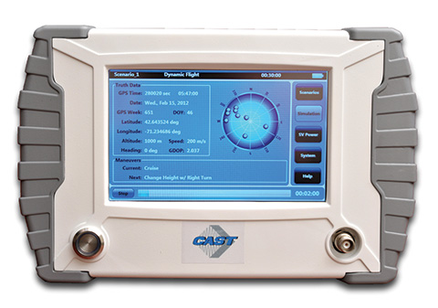
    The new SGX GPS satellite signal simulator from CAST Navigation provides the user with dynamic, repeatable GPS RF signals for use in the laboratory or in the field for a wide range of GPS applications. The SGX simulator is housed in a portable, lightweight, handheld enclosure measuring 7 x 11 x 3 inches and weighing just over 4 pounds.

    The SGX replaces the CAST-SIMCOM simulator, a 17- inch, 50-pound simulator. The SGX is lightweight and portable, operates on AC or battery power, and features 16 channels of L1 C/A and P codes. Based on CAST’s technology that has been developed for use in the company’s larger military products, it is extremely accurate and repeatable.

    The SGX is controlled via an intuitive touchscreen interface that allows the user to select, start, and stop scenarios, change screen views, and change satellite RF power levels while a scenario is running. Three test scenarios are delivered with the simulator.

    XGEN Plus Scenario Generation Software. This optional software gives the user the ability to generate custom scenarios for use with the SGX. The software allows for complete control over GPS almanac, ephemeris, and all satellite error sources.

    The user can select from a variety of vehicle types and simulate static or dynamic motion. The user may also employ antenna gain patterns and vehicle silhouettes if desired. The user may generate a trajectory by defining a total mission profile using a six-degree-of-freedom model. The new scenarios can be downloaded via USB port or SD card interfaces.

    CAST has been in the GPS simulation and support business for more than 30 years, designing, developing, manufacturing, and integrating innovative GPS/INS simulators and associated equipment for government, military, prime vendor, and consumer markets.

    www.castnav.com
    phone: 978 858-0130
    email: [email protected]

    IFEN Inc.

    NavX-NCS Professional GNSS Simulator
    NavX-NCS Essential GNSS Simulator

    NCSPRO-MULTI_SW-W

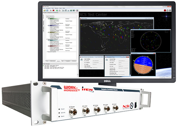
    The absolute flexibility of the NavX-NCS Professional GNSS Simulator allows it to be configured with up to 108 channels and all of the following signals:
    •    GPS L1/L2/L5 C/A & P code and L2C
    •    GLONASS G1/G2 standard & high accuracy codes
    •    Galileo E1/E5/E6 (BOC/CBOC/AltBOC)
    •    BeiDou B1/B2
    •    SBAS L1/L5 (WAAS, EGNOS, MSAS, GAGAN)
    •    QZSS L1 & L1-SAIF
    •    IMES

    The user is enabled to assign signals freely to any of the RF modules fitted to the simulator. This allows the same hardware to be used in a range of different configurations.

    Signals may be added by software license with no need to return the hardware for upgrade.

    Up to four independent RF outputs may be fitted, enabling the user to simulate multiple antenna locations simultaneously (allowing simulation of multiple antennas on one vehicle, multiple vehicles simultaneously, a mixture of static locations and mobile vehicles, and multiple antenna elements forControlled Reception Pattern Antenna [CRPA] testing).

    The comprehensive and easy-to-use Control Center operating software allows the operator to quickly create realistic test scenarios for effective testing of user equipment.

    IFEN also offers the NavX-NCS Essential GNSS Simulator, which is available with 21 or 42 channels and is capable of simulating GPS L1 (including SBAS L1), GLONASS G1, Galileo E1, BeiDou B1, QZSS L1, and IMES. The simulator is also supplied with Control Center operating software for comprehensive scenario generation.

    www.ifen.com
     
    For USA and Canada
    Mark Wilson
    phone: 951-739-7331
    email: [email protected]
    For Rest of World
    Dr. Guenter Heinrichs
    phone: +49-8121-2238-20
    email: [email protected]

    RaceLogic

    LabSat 3

    LabSat3_on-Hand-SD-Screen-W

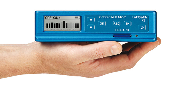
    LabSat 3, the latest generation of GNSS simulators from Racelogic, is a low cost, stand-alone, battery powered, multi-constellation, RF record and replay device designed to assist GNSS engineers in the development and testing of their products. With its small size and all-in-one design, LabSat 3 makes it easier than ever to collect raw satellite data in the same environment that end users experience in everyday use. This enables repeatable and realistic testing to be carried out under controlled conditions.

    LabSat 3 doesn’t need to be connected to a PC to record live-sky GNSS signals. With one-touch recording to SD card and a two-hour battery life, it can be used in any outdoor location to create real-world scenarios, for eventual replay back in the lab. As well as recording GPS, GLONASS, BeiDou, QZSS, Galileo, and SBAS signals, it can simultaneously log CAN bus, serial, or digital data, embedded alongside the satellite information. This additional information can then be replayed alongside the GNSS output, with synchronization to within 60 ns. A 1 PPS signal can also be generated using the internal GPS receiver.

    LabSat 3 can be used as a replay system out of the box with a set of pre-recorded scenarios supplied as part of the package, recorded from various locations around the globe. SatGen software, a free version of which is included with LabSat 3, allows for scenario generation of user-defined trajectories, with precise control over velocity, heading, height, and constellation profiles. Routes are also easily created in Google Maps, and the software also supports NMEA and KML file import. SatGen gives the test engineer the ability to develop a product using simulations that would be difficult or impossible to record due to geographic location or safety constraints.

    LabSat 3 is available in four variants: replay only, or record and replay, of a single channel — one of GPS/Galileo/SBAS/QZSS, GLONASS, or BeiDou; and replay only, or record and replay, of dual channels — two of GPS/Galileo/SBAS/QZSS, GLONASS, or BeiDou.

    LabSat is currently used by many leading manufacturers of GPS chipsets, portable navigation devices, smartphones, and by major car companies in their test, development, and production processes.

    www.labsat.co.uk; phone: +44 (0)1280 823803

    Rohde & Schwarz

    R&S SMBV100A: GNSS Simulator on Vector Signal Generator

    Rohde-Schwarz-Beidou-W

    Rohde & Schwarz extends the functionality of the R&S SMBV100A vector signal generator by adding BeiDou/Compass capability to its integrated GNSS simulator. With the R&S SMBV-K107 option, the GNSS simulator now covers the BeiDou standard as well as the GPS, Galileo and GLONASS satellite navigation systems.

    The new option allows users to generate real-time scenarios with up to 24 BeiDou satellites. R&S SMBV-K107 supports all possible BeiDou orbits and can therefore even simulate satellites that are not yet in orbit. It also supports hybrid scenarios with GPS, Galileo, or GLONASS satellites. A software update makes it easy to upgrade existing GNSS simulators for BeiDou. No hardware modifications are required.

    The R&S SMBV100A permits users to quickly define their own satellite scenarios to test GNSS receivers under diverse conditions. A wide range of options are available for simulating realistic effects such as signal obscuration and multipath propagation. These scenarios can now be configured for BeiDou as well.

    This inexpensive solution is one of the few on the market that does not require an external PC for testing receivers and components of satellite-based navigations systems. In addition to GNSS signals, the R&S SMBV100A can simulate mobile radio, wireless, and radio standards, allowing users to test several functions with a single instrument.

    The new R&S SMBV-K107 option is now available from Rohde & Schwarz.

    www.rohde-schwarz.com
     
    email: [email protected]

    Spectracom

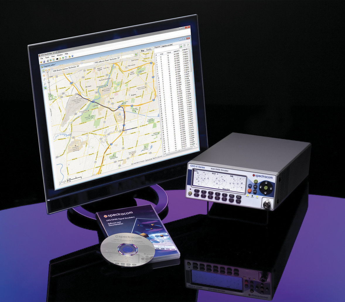
    Configurable, Upgradeable GNSS Simulators

    GSG_Family-SPECTRACOM-W

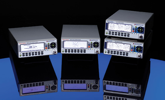
    Spectracom multi-channel, multi-frequency GSG Series GPS/GNSS Signal Simulators are designed for research, development and manufacturing. They provide powerful, affordable, and easy-to-use application-specific GNSS testing solutions allowing users to simulate virtually any condition through built-in and user-defined scenarios. The simulators now feature expanded capabilities and a flexible, field upgradeable design that allows users to select only the features needed for a specific application, upgrade when necessary.

    The GSG 5 and 6 Series simulators are portable and fully operational via front panel, web-based remote control (Ethernet, USB, GPIB), or SCPI protocol. The models include GSG StudioView PC Software to build, edit, and manage complex scenarios and trajectories. Advanced simulation features include: SBAS (WAAS, EGNOS, GAGAN, MSAS), multipath scenarios, interference detection and mitigation, white-noise generation, and trajectories. The new features and capabilities can be added to any GSG-5 or GSG-6 purchased since June 2012.

    GSG-6 Series Multi-Frequency, Advanced GNSS Simulator
    •    Up to 64 channels and 4-frequencies simultaneously
    •    GPS, GLONASS, Galileo, BeiDou
    •    Sync multiple units for testing hundreds of signals
    •    L1, L2, L2C, L5, E1, E5, B1; [E6, B2, B3 capable HW, with FW upgrade available in the future]
    •    P-code, pseudo P(Y) in L1 and L2
    •    Add-ons for real-time scenarios, record and playback, Assisted-GNSS, RTK/Differential measurements, high velocity
    •    Fully upgradable to future constellations and signals

    GSG-5 Series Multi-Channel, Advanced GNSS Simulator
    •    4, 8 or 16 channels
    •    GPS, GLONASS, Galileo, BeiDou
    •    L1, E1, B1
    •    Upgradeable to more channels and frequencies

    GSG-51 Low Cost Single Channel GPS Signal Generator
    •    1-channel GNSS tester for fast, simple manufacturing test and validation
    •    Fully upgradeable to GSG-5 and 6 series

    www.spectracom.com
     
    email: [email protected]; phone: 585-321-5800

    Spirent Federal Systems

    GNSS Simulators

    GSS8000-W

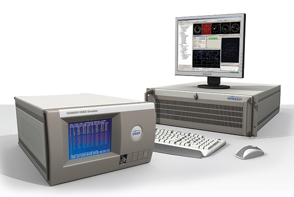
    Spirent provides simulators that cover all applications, including research and development, integration/verification, and production testing.

    GSS8000 (pictured). Spirent’s flagship simulator, the GSS8000, is fully approved for Y-code, SAASM, AES M-code and SDS M-code testing. Spirent provides options and configurations for testing GNSS interference effects and interference mitigation techniques, such as integrated GPS/inertial testing, CRPA testing, and jamming/anti-jam simulation.

    Spirent has delivered simulators that produce legacy signals as well as modernized signals such as 2C, L5, and L1C. In addition to GPS, systems can include GLONASS L1/L2, Galileo, and Beidou-2, plus SBAS (WAAS, MSAS, and EGNOS) and Japan’s Quasi-Zenith Satellite System (QZSS).

    CRPA Test System. Spirent’s Controlled Reception Pattern Antenna (CRPA) Test System generates both GPS L1/L2 and interference signals; multiple GSS8000 chassis may be combined to coherently control up to seven antenna elements. Null-steering and space/time adaptive CRPA testing are both supported by this comprehensive approach.

    GSS7790. Spirent’s GSS7790 Multi-Output Simulation System allows the signal from each satellite to be mapped to a separate RF output. These signals can then be fed to individual transmit antennas, which, when suitably deployed in an anechoic chamber, replicate the spatial diversity of satellite and jammer signals incident on the receiver antenna. Additional flexibility is offered as the signal is further split into its GPS L1 and L2 components, as appropriate.

    www.spirentfederal.com
     
    Jeff Martin, Director of Sales
    Kalani Needham, Sales Manager
    email: [email protected]
    phone: 801-785-1448; fax: 801-785-1294


  • The Business — March 2014

    The Business section of the May 2014 issue. Download the PDF.

    Includes: Spirent’s SimSAFE Fights Signal Vulnerability; JAVAD TR-3 Receiver; Teleorbit Upgrades Simulation Environment; IFEN Contract for Galileo Signal Test Bed; Spectracom Program for Application-Specific Testing; Spectra Precision SP-80 Uses Six GNSS Systems; Briefs

  • Spirent’s SimSAFE Fights Signal Vulnerability

    Spirent’s SimSAFE Fights Signal Vulnerability.
    Spirent’s SimSAFE Fights Signal Vulnerability.

    By Tracy Cozzens

    Spirent Communications now offers SimSAFE, a software solution that simulates legitimate GNSS constellations along with spoofed or hoax signals to evaluate receiver resilience and help develop counter measures.

    Hoax or spoofing attacks work by mimicking genuine GNSS signals, which mislead GNSS receivers.  The military and critical infrastructure — such as wireless networks, banking, and utilities — are especially interested in being able to detect and reject spoofing attacks.

    “GNSS signal vulnerability is becoming a significant issue,” said John Pottle, marketing director of Spirent’s Positioning Division.  “The industry is beginning to talk more about vulnerability and how we actually think about categorizing the threat — what approaches are there to evaluate performance in the presence of interference signals? If you’re a developer, what approaches are there to clean up your performance? You’ll see us at Spirent being quite a bit more vocal about these areas in the coming months.”

    SimSAFE was developed in conjunction with Qascom, a small organization of half a dozen GNSS signal security and authentication experts headed by Oscar Pozzobon, who served as the chief solutions architect for SimSAFE. Pozzobon contributed his knowledge of GNSS security and vulnerabilities, which were then integrated into the SimSAFE system.

    SimSAFE provides a means of emulating a spoofing attack, and then monitoring a receiver under attack to evaluate mitigation strategies and countermeasures.

    “SimSAFE really gets into details on how a receiver reacts in the presence of the hoax signals,” Pottle said. “By really understanding that, really getting into how is the receiver is acting and reacting, you can understand better how your receiver is likely to behave, and tune it up.”

    The SimSAFE laboratory-based test solution is fully controllable, so that users can evaluate a receiver’s response to a wide range of spoofing attacks. As Pottle put it, when fed both authentic and spoofed signals, “What’s the receiver going to see? It’s going to see the authentic signals, it’s going to see a couple of spoofed signals. And you can play around with the spoofed signals — that’s the controllable bit. While this is happening, the detector module within SimSAFE monitors and reports the receiver’s response to the attacks. At its most simple, that’s the power of SimSAFE.”

    SimSAFE is aimed not only at receiver developers, a core audience of Spirent’s, but at anyone trying to build a system that may be subject to intentional interference, such as in the military or critical infrastructure. “Those people are starting to ask questions about what should I be worried about? What kind of an attack might I be open to? How can I be sure, if I’ve got a choice of three or four receivers, that I’m going to choose one that meets my needs in terms of resilience to intentional interference?” Pottle said. “Our belief is that SimSAFE will allow people to evaluate different receivers and strategies for mitigating spoofing attacks, and therefore help them to build the right level of resilience in their systems.”

    SimSAFE is available in two variants. SimSAFE Simulated uses the simulator for all signals, both satellite and spoofed, using one or more channels for the spoofed signal.

    Instead of a simulator, SimSAFE Live pulls authentic signals from sky with an antenna, so the user has the full power of the simulator to generate a much broader range of spoofing attacks. “The clever bit is aligning the spoofed signal with the real signal, getting the timing and frequency synced up,” Pottle said.

    Spirent is also working on other technologies to mitigate spoofing, including work with interference signals from ground-based transmitters, adaptive antenna lab-based tests, and integration with inertial sensors, such as in military jets.

    SimSAFE’s signal control capabilities.
    SimSAFE’s signal control capabilities.