Exelis has successfully completed several software upgrades for the new Global Positioning System Next Generation Operational Control System, or GPS OCX. Integration and testing were recently conducted on iteration 1.5 of the OCX navigation, encryption and Mission Upload Generator, or MUG, software.
The new version of GPS software will help ground controllers better understand the satellites’ exact positioning in space. The encryption software is also designed to automatically code and decode GPS signals, facilitating the exchange of user information by securely transmitting navigation payload data between the OCX ground system and the orbiting constellation of satellites.
The MUG software is responsible for creating spacecraft payload updates to refresh the navigation data transmitted to all GPS users. This data is typically generated for each satellite multiple times a day and helps to consistently minimize user error.
“These software milestones demonstrate a clear path to improved GPS accuracy and integrity,” said Drew Trainor, OCX program manager for Exelis Geospatial Systems. “Civilian and military users will have more accurate and secure GPS signals, and these milestones bring us one step closer to GPS modernization.”
Under a February 2010 contract award from Raytheon, Exelis is providing software that will simulate the behavior of GPS signals in space. In addition, Exelis is building high-precision receivers for use in ground monitoring stations placed strategically around the world. Exelis is also providing data encryptors that help ensure secure information exchange between the ground and space segments of the system.
Once the new operational control segment is implemented, GPS will improve a variety of business and economic practices, including air traffic control, crop management, and environmental monitoring, among others. The new capabilities offered by GPS modernization will also provide military users increased accuracy, availability, anti-jam power and international interoperability.
Telenav, Inc., announced today that it has acquired skobbler GmbH, the European-based navigation company with the highest rated OpenStreetMap (OSM)-based GPS navigation apps in the world. With this acquisition, Telenav brings the most successful OSM navigation experts in the world together as one team — including the founder of OSM, Steve Coast, who joined Telenav in 2013 — and becomes a major contributor to the creation of the open-sourced and most comprehensive map of the world, according to the announcement.
The acquisition closed on January 29 for consideration of approximately $19.2 million in cash and $4.6 million of company common stock.
“Crowdsourced OSM can power personalized navigation services like Scout — with highly detailed maps on a global scale,” said HP Jin, Telenav’s chairman and CEO. “We plan to offer Scout with OSM for much of the world. We have already made significant headway toward this goal in the U.S., including using OSM for our HTML5 version of Scout.”
OSM is the only crowdsourced and open-sourced map of the globe and, for many developers, it has become a clear alternative to Google Maps.
“Waze and Google — or, just Google now — provide similar mechanisms to improve their maps, based mostly on OSM’s innovations. With one big catch. It is very much their map. Not yours,” said Coast in his blog commentary today regarding the acquisition. “OpenStreetMap is different. All of the quality data contributed is openly available — just like Wikipedia. So, anyone can download, experiment and play with it freely. It’s not locked up beyond your reach.”
Since Coast founded OSM, the community has doubled year over year to more than 1.5 million registered editors, becoming a global community of local editors in every corner of the world. Its crowdsourced model publishes edits every minute on openstreetmap.org, resulting in maps that are detailed and up to date. For example, newly laid streets and newly developed areas can be updated on a regular basis and in real time. In addition, OSM allows for greater map detail for pedestrians such as alleys, sidewalks, parks, hiking trails, zoos, and even city trees.
Telenav has been an active contributor to OSM for more than three years, working closely with the community to enhance specific features needed for navigation, traffic and other future location-based services.
With offices in Germany and Romania, skobbler was the first company to launch a commercial navigation app using OSM (in 2010) for both Android and iOS devices and is available in app stores in 49 regions with worldwide map coverage. In order to do this, skobbler developed sophisticated algorithms that evolved OSM data from a display map to a navigable map.
skobbler’s apps are top ranked and highly rated in multiple countries including Germany, the Netherlands, and Sweden. skobbler’s CEO, Peter Scheufen, previously served as the CEO of Navigon, which became a leading GPS device manufacturer in Europe and was eventually purchased by Garmin. The other skobbler founders also held senior roles at Navigon before founding skobbler. Telenav expects that all skobbler employees will join Telenav as part of its OSM team, bringing significant industry-leading software expertise in location-based services, navigation and mapping.
“By joining our efforts with skobbler, we will build on our combined successes to bring the best mapping and navigation services to our customers around the world,” said Jin. “The benefits of an open source model will provide an enormous opportunity to change the economic models of navigation and other location-based services.”
“OSM is currently one of the most active and dynamic crowdsourcing communities and is growing at an explosive rate,” said Scheufen. “Our team lives and breathes OSM and so we are excited to join forces with Telenav to create the largest, most sophisticated, and smartest OSM navigation team in the world.”
In connection with the acquisition and in accordance with NASDAQ Marketplace Rule 5635(c), Telenav granted four employees of skobbler and its subsidiaries, upon the closing of the acquisition, restricted stock units for an aggregate of 634,920 shares of common stock.
These RSUs were granted outside of the existing Telenav stock plans and without stockholder approval pursuant to NASDAQ Marketplace Rule 5635(c)(4) with the following terms: each RSU vests as to 50% of the award on the anniversary of Acquisition and as to 50% of the award on the second anniversary of the Acquisition, subject to continued employment through each relevant date.
Applanix Corporation and American Aerospace Advisors have completed a successful series of test flights of AAAI’s RS-16 platform equipped with Applanix’ DMS-UAV aerial photogrammetry payload. This is the first successful mission for a long-endurance UAS (unmanned aerial system) capable of producing professional-grade, directly georeferenced mapping imagery for civilian applications such as pipeline monitoring, power line and emergency response mapping.
The RS-16 Unmanned Aircraft System equipped with the Applanix Direct Mapping Solution (DMS).
Tests were conducted over restricted airspace in the state of New Jersey. A joint team from Applanix and AAAI planned and flew a sequence of missions to evaluate the capabilities of the UAS. These include, critically, the ability to provide highly accurate, directly georeferenced and orthorectified aerial imagery without the need for ground control points or aerial triangulation calculations. The system, consisting of the airframe, its avionics, mobile ground control station and the digital mapping payload, performed according to expectations and successfully produced high-quality imagery.
“Performing safe and successful missions with long endurance unmanned aircraft in civilian airspace are a challenge that goes far beyond selecting the right aircraft and payload,” said David Yoel, CEO of American Aerospace Advisors. “Working with Applanix, we have produced an integrated system that is designed from the ground up with civilian mapping operations in mind. We believe this system has the capability to transform the aerial mapping industry.”
The Applanix RS-16 in flight.
The RS-16 DMS is a complete, operational system capable of conducting large area operations within the National Airspace System in the United States, and in other jurisdictions as local regulations allow. Within the USA, AAAI is engaged with several of the recently announced UAS research and test sites, which operate under the auspices of the FAA to develop the certification and operational requirements necessary to safely integrate UAS into the national airspace.
The GNSS-Inertial systems at the core of Applanix’ DMS-UAV aerial mapping payload uses commercial inertial technologies that are offered globally.
“The market for airborne imaging systems is in a state of rapid change,” said Joe Hutton, director of Inertial Technology and Airborne Products at Applanix. “Developments in imaging technology, in processing capability, and in the nature of inertial sensors, make a directly georeferenced UAS a reality today, where it would have been inconceivable even a few years ago. Our ability to take our established market-leading manned solutions, and integrate the technology successfully into an unmanned platform, speaks volumes for the engineering expertise of Applanix and AAAI.”
The Lockheed Martin team developing the U.S. Air Force’s next generation Global Positioning System (GPS) recently turned on power to the bus and network communications equipment payload of the program’s second satellite designated GPS III Space Vehicle 2 (SV-02).
The successful powering on of GPS III SV-02, on December 19, 2013, at Lockheed Martin’s Denver-area GPS III Processing Facility (GPF), is a major production milestone which demonstrates the satellite’s mechanical integration, validates its interfaces, and leads the way for electrical and integrated hardware-software testing.
“The GPS III SV-02 bus power on is a significant milestone, positioning SV-02 in line with the Air Force’s first GPS III space vehicle, SV-01, in our GPF, where both satellites are progressing through sequential integration and test work stations specifically designed for efficient and affordable satellite production,” explained Mark Stewart, vice president for Lockheed Martin’s Navigation Systems mission area.
On November 11, 2013, the propulsion core module for SV-02 was delivered to the GPF from Lockheed Martin’s Space & Technology Center, in Stennis, Mississippi, where the core was manufactured. The structural backbone of the satellite, the core contains the integrated propulsion subsystem that allows the GPS III to maneuver on orbit immediately after launch, as well as to conduct repositioning maneuvers throughout its mission life.
The GPS III program will affordably replace aging GPS satellites, while improving capability to meet the evolving demands of military, commercial and civilian users, Lockheed Martin said. GPS III satellites will deliver three times better accuracy; provide up to eight times improved anti-jamming capabilities; and include enhancements which extend spacecraft life 25 percent further than the prior GPS block. The GPS III also will carry a new civil signal designed to be interoperable with other international global navigation satellite systems, enhancing civilian user connectivity.
Lockheed Martin is under contract for production of the first six GPS III satellites (SV 01-06), the first four funded under the original contract and the fifth and sixth recent fully funded by an exercised Air Force option on December 13, 2013. Lockheed Martin had previously received advanced procurement funding for long-lead components for the fifth, sixth, seventh and eighth satellites (SV 05-08).
The first GPS III satellite (SV-01) was powered on February 28, 2013. GPS III SV-01’s spacecraft bus and antenna assemblies were delivered to Lockheed Martin’s GPF this summer. SV-01 is now in the integration and test flow leading to delivery “flight-ready” to the Air Force.
The GPS III team is led by theGlobal Positioning Systems Directorateat the U.S. Air Force Space and Missile Systems Center. Lockheed Martin is the GPS III prime contractor with teammates Exelis, General Dynamics, Infinity Systems Engineering, Honeywell, ATK and other subcontractors. Air Force Space Command’s 2nd Space Operations Squadron(2SOPS), based at Schriever Air Force Base, Colo., manages and operates the GPS constellation for both civil and military users.
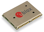
u‑blox has introduced its MAX, NEO and LEA GNSS modules in its next-generation, multi-constellation positioning platform u‑blox M8.
The new module series satisfies a wide range of requirements by providing a scalable range of features including antenna management, integrated filters, data logging, crystal or TCXO, and rich set of interfaces, u-blox said.
The modules can acquire and track all visible GPS, GLONASS, BeiDou, QZSS and SBAS satellites and can track any two GNSS systems simultaneously for increased reliability, accuracy and faster acquisition time. For an overview of all modules, click here to download u-blox’ GNSS module selector guide.
“Our advanced u-blox M8 modules are the result of u-blox’ in-house GNSS chip design expertise and end-to-end ownership of the entire IC and module manufacturing processes. This gives us full control over features, quality and production allowing us to react quickly to customer requirements,” said Thomas Seiler, u-blox CEO. “Being independent of third-party GNSS chip suppliers means we offer our customers exactly the right feature set, chip and module options, smooth upgrade path and a clearly defined product roadmap extending years into the future.”
u-blox’ online assisted-GNSS service, AssistNow, has also been radically improved to support an unbeatable level of global positioning performance. The free service is available in online and offline versions and supports both assisted GPS and GLONASS.
The MAX-M8, NEO-M8 and LEA-M8 modules provide cutting edge positioning performance and -167 dBm tracking sensitivity for a wide range of applications including vehicle and asset tracking, eCall / ERA-GLONASS emergency call systems, vehicle telematics for insurance, road pricing and anti-theft devices, navigation, security, and point-of-sales terminals.
u-blox continues to offer u-blox 7 based modules MAX, NEO and LEA-7 which remain optimal for low-power, cost-efficient, single-GNSS designs. The new u-blox M8 modules maintain hardware and software compatibility with u-blox 7 modules to allow easy upgrade or product variants utilizing the same PCB layout.
u‑blox’ capability of delivering u-blox 7 and u-blox M8 GNSS technologies in both module and integrated circuit form-factors provides maximum design flexibility and protects customers’ development investments over successive product generations.
First samples and evaluation kits for u-blox M8 modules are available for customer evaluation.
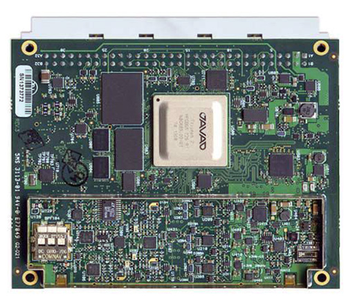
The 864-channel TRE-3 receiver, just announced by JAVAD GNSS, can simultaneously access all current GNSS signals, with room to spare for multiple-channel tracking of select signals, according to the company. The new product offers many features, including:
Three ultra wide-band (100 MHz) fast sampling and processing, programmable digital filters and superior dynamic range. After 12-bit digital conversion, nine separate digital filters are shaped for each of the nine GPS L1/Galileo E1, GPS L2, GPS L5/Galileo E5A, GLONASS L1, GLONASS L2, Galileo E5B/BeiDou B2/GLONASS L3, Galileo altBoc, Galilee E6/BeiDouB3/QZSS LEX, and BeiDou B1 bands.
Each band consists of a combination of a digital cascaded integrator-comb (CIC) filter and a digital finite impulse response (FIR) filter (up to 60-th order) where signal selection is performed.
Two types of digital in-band anti-jamming filters (automatic 80-th order and “user selectable” 256-th order).
Multiple channels to acquire and track each satellite signal. For example, 20 channels can be assigned to acquire the GPS L1 signal, each spaced one millisecond apart. Up to 5 channels can be assigned to track each signal, each with different filter parameters and tracking strategies. This supports acquiring and tracking weaker signals in difficult conditions, especially under trees and canopy — potentially using up to the 864 channels available in the receiver! Several patents are pending.
80 dB out-of-band interference rejections: high dynamic range of wide RF bands and highly rectangular digital filters make the receiver much more resistant to out-of-band jamming.
High-speed high-dynamic automatic gain control (AGC) to respond to interferences and signal variations.
Programmable filter width (by commands).
Highly stable digital filters (band characteristics do not change with age, input voltages, or temperature).
Improved GLONASS inter-channel bias performance (due to a flat digital filter shape).
New multipath rejection technique.
60-MHZ-wide Galileo altBoc band takes advantage of the full benefit of this signal. Its multipath resistance is improved even beyond that of the company’s new multipath reduction technique, it asserts.
864 GNSS channels allow tracking all current and future satellite signals.
Three wide-band RF sections enable monitoring spectrums and interferences in three 100-MHz-wide bands.
TRE-3 can track and decode the QZSS LEX signal messages, making it a unique product on the market in this regard, according to the company.
Features for time -transfer applications: In time sources where the zero crossing of the input frequency defines the exact moment of the time second, the receiver monitors zero crossings and accurately defines the moment of the time second. An external time interval measurement unit is not required to measure zero crossing and 1-PPS offset.
Embedded calibrator measures phase and code delays of each of the nine bands in timing applications. External calibration is not required.
TRE-3 is form, pin-out, and command compatible with the company’s earlier TRE-G3T receiver. It uses 8-Watts of power, compared to 4-Watts of the TRE-G3T
JAVAD GNSS has published an invitation to professional land surveyors in the United States to submit resumés for consideration. The company says it seeks “talented” surveyors to advise on its customer support and to participate in evaluating product features and ideas.
Singapore-based Miclyn Express Offshore (MEO), a provider of offshore support vessels across South East Asia, Australia and the Middle East, has awarded Veripos a five-year contract for provision of high-precision GNSS positioning services in support of its fleet of 27 ships.
Under the terms of the contract, Veripos will provide MEO’s fleet with Veripos Ultra Precise Point Positioning (PPP) service designed to deliver decimeter-level accuracies globally along with associated integrated mobile receivers. Among the first vessels assigned to utilize the service and equipment are MEO’s new 2,000 dwt platform supply vessels, MEO Ranger and MEO Resolution, both of which have been equipped with LD5-GG2 receivers. Meanwhile, four older MEO vessels have been similarly configured to receive Veripos Ultra service.
Commenting on the latest contract award, Walter Steedman, Veripos chief executive officer, said it further consolidated the company’s continuing leadership for provision of precise GNSS positioning services for offshore applications throughout the region and beyond.
Miclyn Express Offshore employs more than 1,400 shore-based personnel and seafarers.
Garmin International has introduced two new handhelds geared for the golf aficionado, including a new top-of-the-line model, the Approach G8.
The Approach G7 and G8 golf handhelds have color touchscreens, more than 30,000 preloaded international courses, a rechargeable battery capable of multiple rounds, and new measurement features such as PlaysLike Distance, which shows adjusted range for uphill and downhill shots.
For golfers who prefer to leave their smartphones in their bags, the new Approach handhelds offer Smart Notification technology, which lets the user pair a compatible iPhone 4S or later to receive emails, texts, and call alerts on the device (Android compatibility is expected in the second quarter of this year). The devices are also compatible with Garmin Connect, so users can upload their scores and track their progress over time.
Both the Approach G7 and G8 incorporate the new measurement feature PlaysLike Distance, which adjusts distances for uphill and downhill shots, so players get the most accurate yardage measurements. Both devices also offer Club Advice, which remembers how far users hit each club and makes recommendations based on shot distances.
Another new feature in the G7 and G8 golf handhelds is the Big Numbers mode, so users can easily see the vital information they need without squinting or reading glasses.
The Approach G7 and G8 handhelds come preloaded with more than 30,000 international courses, with no extra subscriptions or fees. Both devices give precise distance to the front, back and center of the green, as well as layup and dogleg distances. Both devices have a rechargeable battery that plays an entire weekend of golf (15 hours) on a single charge.
The Approach G7 and G8 double as digital scorecards with scoring options for Stroke Play, Stableford, Skins and Match Play with adjustable handicaps. Users can save, review, share and print scores for up to four players. With the vibrant screen, the G7 and G8 offer colorful layup arcs at 100, 150, 200 and even 250 yards, so users know exactly how far to hit when laying up.
The Touch Targeting feature lets users touch any point on the display, and will give the precise distance to that exact spot, no matter if it is on the fairway, a hazard, a landing area, or even the front, middle or back of the green.
Like other Approach devices, the G7 and G8 have Green View, which allows users to zero in on a map of the green and manually position the pin in order to get the most accurate yardages. There is also an advanced Stat Tracking feature in the G7 and G8, which keeps track of fairways hit, greens in regulation and putts per round. These stats can be viewed during the round, or can be downloaded afterwards.
The premium Approach G8 also provides blind shot assistance with the new PinPointer feature, which shows the user the exact center of the green even if it’s not visible, and points them in the right direction for more accurate blind shots. Additionally, it adds Wi-Fi, so the G8 will automatically update courses when connected to Wi-Fi at no additional cost. The G8 rounds out the Approach family as the top-of-the-line golf handheld from Garmin.
New to the Garmin golf lineup, the Approach G7 and G8 will now be compatible with Garmin Connect. With the recent revamp of the online community, owners with Approach G7 and G8 will be able to upload, analyze and share their scorecards, as well as other data like fairways hit, greens in regulation, shot distance and number of putts. Users can keep track of whom they’ve played against, and who won each round. They can analyze course data, and see hole-by-hole details to understand their own trends and tendencies to improve their game. This is great to track users’ progress and improvements over time for every course they play.
Rugged, and with a water rating of IPX7, the Approach G7 and G8 are durable enough to withstand a rainstorm, or users’ golf bags without fear of damage. The Approach G7 and G8 will be available in Q1 2014. The Approach G7 will retail for $299.99 and the Approach G8 will retail for $399.99, and will be available at specialty golf retailers, golf course pro-shops and on garmin.com.
GNSS simulation expert Spirent Federal is inviting users to “a rigorous and thorough” one-and-a-half-day training conference, including a half-day of For Official Use Only (FOUO) sessions, set for March 26-27 in Salt Lake City.
The 2014 Spirent Federal GNSS Training Conference features hands-on training led by Spirent engineers on its latest GNSS simulation equipment. FOUO sessions will be held on Thursday, March 27, for U.S. citizens only.
Topics covered include:
SVN49 anomaly simulation
Utilizing remote control and motion
Advanced modeling and simulation techniques
Differential GPS and augmentation systems
Multi-GNSS constellation testing
Integrated GPS/inertial testing (FOUO Session)
M-code simulation (FOUO Session)
CRPA testing (FOUO Session)
General sessions will be held Wednesday and Thursday, March 26-27. FOUO sessions will be held Thursday, March 27.
For information and to register, visit the event website.
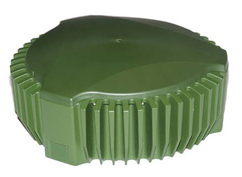
Public Works and Government Services Canada (PWGSC) has selected NovAtel’s GAJT-700ML antenna for testing on Canadian Army armored vehicles. The GAJT-700ML, developed in Calgary at NovAtel’s global headquarters, is a single-unit GPS anti-jam antenna system for land vehicles.
The testing is being conducted through PWGSC’s Build in Canada Innovation Program (BCIP).
NovAtel was selected to participate under the BCIP’s “safety and security” priority area. PWGSC will procure a number of GAJT-700MLs on behalf of the Department of National Defense (DND). The Directorate of Land Requirements (DLR) — with the assistance of the Quality Engineering Test Establishment (QETE) and the Land Force Trials and Evaluation Unit (LFTEU) — will oversee all testing on DND’s behalf.
Field testing, centered on battlefield days, is expected to take place in early March of 2014 at 4th Canadian Division Support Garrison Petawawa. The battlefield days will analyze the performance of GAJT on the Artillery Observation Post Variants (OPV) of the Light Armored Vehicle III (LAV III) in operational conditions to confirm the suitability and robustness of GAJT-700ML for this role. The process is expected to be completed by the end of March.
“NovAtel has worked closely with Canadian and Allied defence agencies to test the resilience of the GAJT-700ML in challenging jamming environments,” said Jason Hamilton, vice president, Marketing and Product Management. “The BCIP program provides an opportunity to expand this testing to incorporate end user soldier feedback on the installation and operational effectiveness of GAJT during battlefield usage of the LAV OPV. This invaluable feedback will be used by NovAtel to further drive product innovation in support of Canada and its Allied partners.”
“The Canadian Army requires accurate, secure and reliable access to Global Positioning Systems to conduct operations throughout the full spectrum of conflict in all potential theatres of operation,” said Colonel Andrew Jayne, Director Land Requirements. “With the ever-increasing demands on the electromagnetic spectrum and threat of harmful interference, technologies which contribute to the assurance of position and timing information are a critical enabler of Army and Canadian Armed Forces operations in today and tomorrow’s operating environment.”
GAJT is a null-forming technology that negates jammers, ensuring the satellite signals necessary to compute position and time are always available. Three categories of GAJT are manufactured by NovAtel:
GAJT-700ML: for use with military land vehicles, networks and timing infrastructure
GAJT-700MS: for marine vessels, from small boats to capital ships
GAJT-AE: for use with an external antenna in size and weight constrained applications
The BCIP was created by the Government of Canada to strengthen Canadian innovation. The program offers procurement and testing of pre-commercialized products and services, at a late stage of development. The BCIP:
Bridges the “pre-commercialization gap”
Supports Canadian suppliers by connecting innovators and government users and by testing innovations
Provides real-world evaluation of pre-commercial goods and services
Improves the efficiency and effectiveness of government operations