The regulatory announcement explains that Hexagon, Topcon Europe B.V. and Topcon Corporation have entered into a memorandum of understanding (MoU) related to Veripos, Inc. Hexagon Acquisition Ltd., an indirectly wholly owned subsidiary of Hexagon, has made an unconditional cash offer for all outstanding shares in Veripos not already owned by Hexagon Acquisition Ltd. Hexagon Acquisition Ltd. owns and has received acceptances and pre-acceptances for a total of 9,980,630 shares, representing 30.1 per cent of the outstanding shares in Veripos.
Under the MoU, Hexagon would establish a customer agreement between Topcon and Veripos, under which Topcon will act as a reseller of the satellite broadcast correction signal offered by Veripos. This “TerraStar Agreement” between Veripos and Topcon is intended to be an agreement with TerraStar GNSS Ltd., a wholly-owned subsidiary of Veripos and the contractual partner for all resellers and customers of the on-shore services. Under the TerraStar Agreement, Topcon will be entitled to offer the signal to its customers and to make its products compatible with the signal.
Also under the MoU, Hexagon and Topcon will establish a separate joint venture company on an equal partner basis for the purposes of pursuing joint efforts and cooperation in relation to the future development and direction of the services provided under the TerraStar Agreement.
GNSS receiver manufacturers who are partners with TerraStar include NovAtel, Altus Positioning Systems, and Septentrio Satellite Navigation.
The acceptance period for the unconditional cash offer expires on January 29, subject to further extensions but not beyond February 7.
The new Mazda3 infotainment system, which appears in Mazda3’s Active Driving Display, is now running on NNG’s iGO navigation engine, and includes TTS, voice recognition and full 3D navigation.
This solution, supported by Mazda’s MZD Connect, is also reportedly the first on the market to offer an embedded connected-service package with Internet connection provided through the driver’s smartphone. Drivers will be able to access dynamic local search, fuel prices, real-time traffic and weather information free of charge in the first 60 days, and benefit from three years of free map updates.
“Mazda’s new design, KODO, has really inspired us to develop an integrated infotainment system, with knowledge and refined features matching the look and performance of the car,” said Péter Balogh, NNG. “We succeeded in offering cutting-edge solutions in the head unit, enhanced safety, usability and comfort to the driver.”
Hyundai Motor America has selected Verizon Enterprise Solutions to provide a range of connected services including safety, security, diagnostics and infotainment to Hyundai vehicles starting in 2014.
“We selected Verizon to provide the wireless network service for ‘Next-generation Blue Link’ because both customer opinion and various data sources indicate that Verizon provides the best solution to our customers for both coverage and quality,” said Woo-Young Kwak of Hyundai Motor Group.
Hyundai vehicles are distributed throughout the United States by Hyundai Motor America and are sold and serviced through more than 820 dealerships nationwide. According to Forrester Research, the number of vehicles shipped worldwide with embedded connectivity is expected to grow from 5.4 million in 2012 to 36 million in 2018.
“Our agreement with Hyundai expands our long-standing collaboration with a wide range of auto manufacturers throughout the industry to support network engineering, security, cloud solutions, telematics platform, and program management for millions of vehicles in the U.S. and around the world,” said Mark Bartolomeo of Verizon Enterprise Solutions. “We are thrilled to be working with Hyundai to help enhance the driving experience for their customers. It’s the breadth of our expertise combined with the depth of our technology that allows our clients to launch new services and initiatives faster.”
AT&T and Sabre, a global travel technology company, announced they will jointly explore solutions that could usher in a more personalized experience for travelers. The two companies are developing and testing solutions that will utilize AT&T’s newly enhanced Location Information Services (LIS) – Hybrid, which allows developers to build geo-aware mobile applications. The companies are exploring how device-based location information services can help airlines, airport retailers, and other travel-related companies deliver intelligent, predictive and personalized services throughout a traveler’s journey.
AT&T LIS Hybrid has the ability to define custom geofences (a virtual perimeter within a geographic area) in any shape or size, both indoors and out, using cellular, GPS and Wi-Fi information shared by the user from their devices. Knowing when a traveler enters or leaves a pre-defined geofence would allow travel suppliers to provide personalized services and relevant offers based on the traveler’s real-time location.
“By applying cutting-edge technologies, coupled with data analytics and better intelligence, we can give travelers the personalized experience they have come to expect in today’s connected world,” said Sarah Kennedy of Sabre Labs, the technology incubator and research lab at Sabre. “Together with AT&T, we will explore the role advanced location-based services can have in helping travel suppliers provide better, more personal service to their customers.”
The app might alert airline staff when a high-status passenger is still clearing security when her flight is due to depart; or notifies travelers of special promotions as they approach an airport bookstore; or warns a passenger if he is in the wrong terminal for his connecting flight. The two companies are exploring technology that could underpin these types of apps across almost all types of smartphones, tablets and operating systems. Any services developed as part of the trial will meet location services best practices guidelines when it comes to customer privacy including customer opt-in.
“Our application programming interface, or API, and software development kit allows companies like Sabre to build multi-carrier geo-aware mobile applications,” said Laura Merling, of AT&T. “AT&T LIS Hybrid works with Wi-Fi as well as existing cellular device-based information location services such as GPS, to deliver near-precise device location information indoors and outdoors.”
Phase one of the pilot project between Sabre and AT&T is expected to be completed during the first half of 2014.
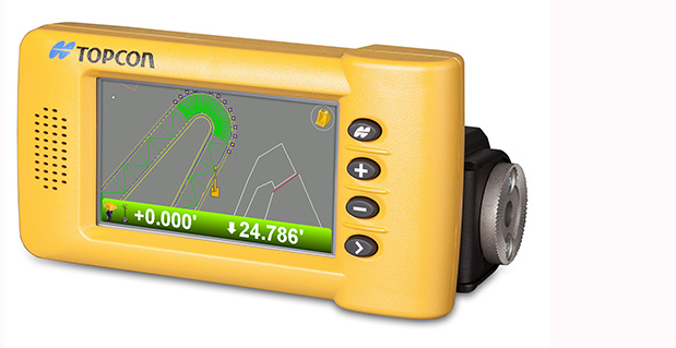
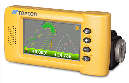
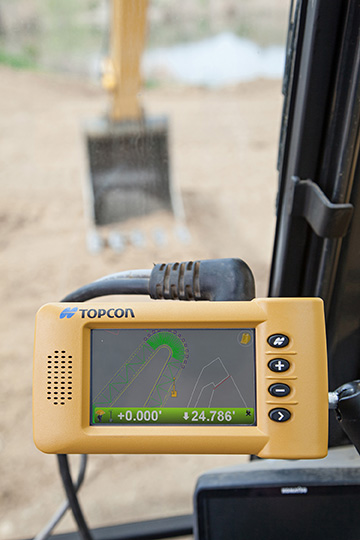
Topcon Positioning Group announces the addition of two new indicate control systems to its excavator control system lineup — the X-32 and X-33. The systems feature Topcon’s new GX-30 control box and TS-i3 sensors.
The GX-30 features a full-color touchscreen display. The TS-i3 sensors have no moving components, offer single and dual-axis measurement modes, and include convenient LED status indicators.
“The X-32 is a versatile and easy-to-use 2D excavator system that includes technology not available on other, more expensive systems,” said Kris Maas, manager for machine control product marketing.
“The X-32 is an excavator grade indication system to fit any budget. With this new system, you have the flexibility to use a wide array of references from which to work: Existing surface, a hub, previous cut, single slopes and dual slopes with the use of a compass or rotating laser. It’s as easy as choosing your reference and entering a cut and/or slope depth,” Maas said.
“The X-32 allows an operator to work faster, with consistency and greater degree of accuracy, and promotes a safer work site by keeping a grade checker out of the trench.”
Additionally, Maas said, “The X-32 grows as your needs expand because it’s easily upgradeable to a 3D system.”
“The X-33 adds Topcon’s industry-leading GNSS satellite technology to create a highly productive 3D indicate excavator grade control system,” Maas said. The system’s MC-i3 GNSS receiver with Vanguard technology provides “maximum flexibility in satellite signal tracking. Additionally, the MC-i3 is Sitelink3D ‘ready’ for integration into Topcon’s real-time 3D management solution,” he said.
The new 3D system is designed to establish grade faster and ensure the operator stays on grade. “The system eliminates over excavation and controls material usage, allowing the user to ‘see’ the exact position of the machine on site and the bucket position at all times,” Maas said. When detailed information is required, the operator can select to visualize the plan, profile, or sectional view and use the dual grade indicators for elevation control.
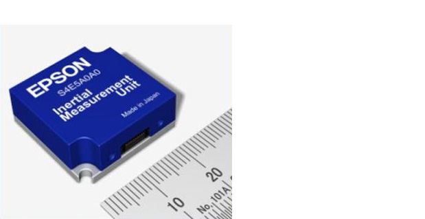
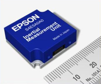
Epson Electronics America has announced a strategic partnership with Geodetics Incorporated of San Diego, California, for production of a new variant of its Geo-iNAV product.
According to the announcement, Geo-iNAV is a fully-integrated GPS-aided inertial navigation system that provides real-time, high-precision positioning and navigation for manned and unmanned air, sea and ground vehicles. It combines GPS and proprietary sensor fusion technologies to achieve centimeter-level real-time positioning and navigation for dynamic platforms. Geodetics will offer Geo-iNAV integrated with Epson’s new G362 and G352 IMU modules. The G362 and G352 are the world’s highest performance IMUs on the market in their size, weight and power class, the company said.
“Geodetics has the high-precision navigation expertise necessary to integrate IMU and GPS technologies, producing Inertial Navigation Systems (INS) that meet the performance requirements of very demanding applications,” said David Gaber, EEA’s IMU product line manager. “The combined solution, called Geo-iNAV Tactical, is a cost-effective, tactical-grade INS in a compact package with no EAR or ITAR export control restrictions.”
Geodetics President and CEO Lydia Bock added, “Epson has established a new benchmark for MEMS IMU performance, enabling Geodetics’ products to reach new applications and customers by delivering high performance for a significantly lower cost than competing devices.”
Epson says that with recent advances in unmanned vehicle technologies, the GNSS ecosystem has expanded to support mission-critical applications, which require more accurate navigation. Geo-iNAV Tactical delivers this capability with features to support reliable and precise navigation with a low SWaP (size, weight and power) profile for autonomous vehicles and payloads on manned vehicles. Geo-iNAV Tactical is offered in several configurations designed to meet a wide range of requirements and is available in commercial as well as SAASM configurations.
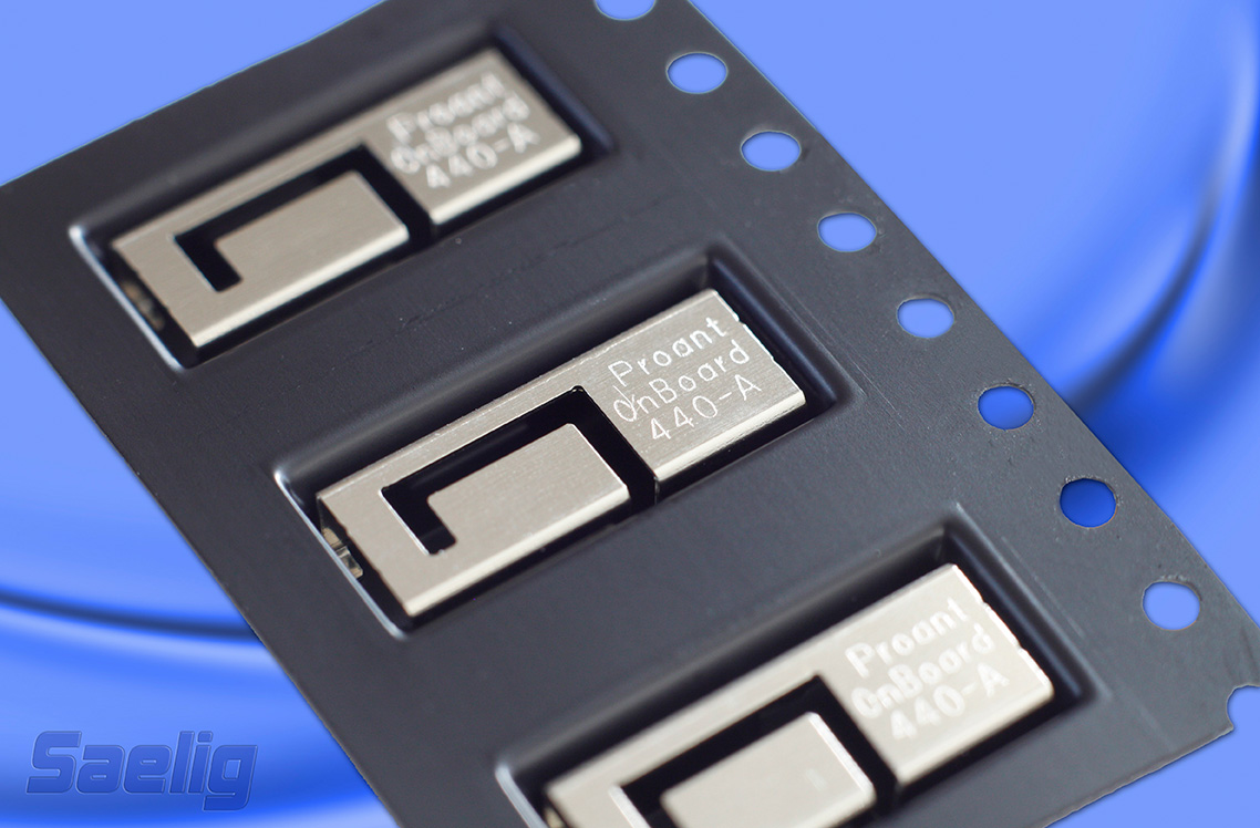
Saelig Company, Inc., announces the availability of the Proant OnBoard SMD 2400 (2.4GHz band) and SMD GPS (GPS and GLONASS) miniature surface-mount (SMD) antennas for mobile wireless products. The OnBoard series moves embedded antenna integration one step ahead by combining high performance and low cost in this new OnBoard SMD family, the company said.
Traditionally, small low-cost antennas for printed circuit board assembly have been manufactured with a dielectric substrate as the base for the radiating structure. With this approach, the antenna is normally a rectangular block, which means that the PCB area below the antenna is unavailable for mounting other components. Another drawback is that the substrate itself introduces dielectric losses to the antenna, reducing its total efficiency.
Proant has taken the concept of small SMD antennas one step ahead by increasing both the antenna performance and design flexibility, and combining this with low cost and manufacturability. The result is the new OnBoard SMD antenna family, which builds on previous OnBoard antennas, but in a surface mounted sheet-metal solution, packaged in tape-on-reel and suitable for high volume manufacturing. One of OnBoard’s key features, which eliminates the need of the dielectric substrate used in other SMD antennas, is the patent-pending capacitively-loaded footprint of the antenna’s supporting pins, which significantly reduces losses and increases the performance.
The first two products to be launched in this 50 ohm RoHS-compliant family are OnBoard SMD 2400 (2.4GHz band) and SMD GPS (GPS and GLONASS). Future variants will include WLAN dual-band, 868/915 MHz, and GSM versions.
“We wanted to simplify antenna integration for our customers,” said Tomas Rutfors, CEO of Proant. “The solution was to make a simple product that satisfies both engineering and sourcing needs. With the OnBoard SMD family, we have defined a new product segment, which didn’t exist before.”
Made in Sweden by Proant AB, a widely respected specialist antenna company in the M2M and wireless market, providing a wide range of embedded and external antennas, OnBoard SMD 2400 (2.4GHz band) and SMD GPS (GPS and Glonass) are available now at under $1 (1000 pcs) from Saelig Company, Inc., the USA technical distributor. A demonstration board is also available at $35.
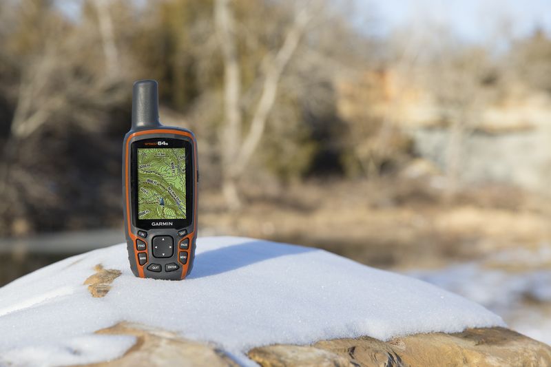
Garmin International Inc., a unit of Garmin Ltd., today announced the GPSMAP 64 series of rugged outdoor handhelds. The GPSMAP 64 series brings a dual GPS and GLONASS receiver, preloaded geocaches and smartphone connectivity for LiveTrack and Smart Notification to its product line for hikers, hunters, and geocachers.
“Building on the popularity of the GPSMAP series, the new GPSMAP 64 series improves functionality to make a top-notch device even better,” said Dan Bartel, Garmin vice president of worldwide sales. “The GPSMAP 64 is ideal for anyone, no matter if it’s their first handheld, or if they’ve used Garmin for years. It combines trusted Garmin technology with the comfort of a device people know and love.”
The GPSMAP 64 series has a 2.6-inch sunlight-readable transflective color display and a high-sensitivity GPS and GLONASS receiver with a quad helix antenna for superior reception. With the addition of GLONASS satellites, the time it takes for the receiver to lock on to a position is (on average) approximately 20 percent faster than using GPS alone. This allows users to get their position quickly and precisely even in heavy cover and deep canyon.
The GPSMAP 64 series features three distinct water-resistant (IPX7) models to suit various activities and interests. The basic GPSMAP 64 includes a built-in worldwide basemap with shaded relief, and supports BirdsEye Satellite imagery and TOPO U.S. 24K maps. The GPSMAP 64s adds a 3-axis electronic compass and barometric altimeter. Additionally, the 64s adds wireless connectivity for data transfer between other compatible Garmin handhelds and mobile apps, and for Smart Notification technology. With this, users can receive emails, texts and alerts on the device (when paired with an iPhone 4S and later). This allows users’ smartphones to be safely protected from the elements. The 64s also comes with a one-year subscription of BirdsEye Satellite Imagery. The GPSMAP 64st includes preloaded U.S. 100K topographic maps. With this, users will be able to search for points of interest by name or proximity to their location and view descriptive details for terrain contours, topo elevations, summits and geographical points.
For outdoor adventurers, the rugged GPSMAP 64 devices are compatible with BaseCamp, a free software download that allows users to view and organize maps, waypoints, routes and tracks. The 64s and 64st models are compatible with the BaseCamp mobile app for data transfer, and the Garmin Connect mobile app, for features such as LiveTrack. With LiveTrack, users can pair their device with the app, and invite friends and family to follow their activity in real time. This provides peace of mind, especially if users are alone. Through ANT+, the 64s and 64st models are also compatible with external sensors such as an external temperature sensor and heart rate monitor. With ANT+, the 64s and 64st models can act as a remote for the new VIRB and VIRB Elite action cameras.
Each device comes preloaded with the locations of 250,000 geocaches from Geocaching.com. Devices store and display key information to find the hidden containers including the geocache coordinates, terrain rating, its difficulty, hints and descriptions, so users no longer have to manually enter coordinates or print out geocache info. By going paperless, users are helping the environment, and improving their efficiency. If users would like to continue geocaching beyond the preloaded geocaches, when they register their device they can sign up for the free premium membership trial through Geocaching.com, and download more geocaches. The GPSMAP 64 devices can store millions more, so users will no longer have to pick and choose which geocaches they want to load on their device.
All of the devices in the GPSMAP 64 series have a dual-battery system, where both standard AA batteries and a rechargeable NiMH battery pack (sold separately) can be used. The devices have internal memory (4GB for 64/64s and 8GB for 64st), and a microSD card slot to store additional data and maps.
The new GPSMAP 64 series will be available this month. The GPSMAP 64 will retail for $299.99, the GPSMAP 64s will retail for $399.99, and the GPSMAP 64st will retail for $499.99.
Loctronix Corporation, a provider of unified positioning solutions for GNSS-challenged environments, has announced the availability of the ASR Workbench, a development toolset for the company’s recently released ASR-2300 software-defined radio (SDR) module. The ASR-2300 is a function-rich SDR for high-performance positioning, navigation and timing (PNT), and communication applications, the company said.
“The ASR-2300 delivers advanced SDR capabilities in a small, mobile form-factor enabling developers to readily create and field complex SDR-based solutions. The new ASR Workbench tool makes it easy for developers to take full advantage of the ASR-2300’s capabilities,” said Michael Mathews, Loctronix’ CEO and founder.
The new ASR Workbench is a Windows-based Integrated Development Environment (IDE) for SDR applications development and testing. It comes with a drag-and-drop, real-time DSP modeling tool with integrated support for the ASR-2300. With ASR Workbench developers will be able to:
Process multiple ASR-2300 baseband I/Q sample streams.
Access a variety of DSP processing and visualization blocks for use in custom models.
Record/playback signals, analyze received signals using a variety of demonstration models.
Optimize the performance and configuration of the ASR-2300 module with a suite of diagnostic tools.
Export data into formats supporting additional analysis using a variety of standard tools including Matlab/Simulink, Excel, etc.
Loctronix’ ASR-2300 SDR module provides multiple, fully-integrated RF paths supporting reception of GNSS, cellular, ISM band, and UHF signals of opportunity, making it suitable for demanding scientific, military, aerospace and commercial/industrial applications, such as UAV/UAS navigation, GPS-challenged or -denied tracking and navigation, combined communications and navigation radios, and GPS integrity monitoring and validation, according to Mathews.
“Using an SDR effectively is challenging due to the steep learning curve required to take advantage of its many programmability benefits. At Loctronix, one of our highest priorities is to provide tools that simplify complex application development. It is not enough to provide just an API and hardware for the user community and hope that they will learn how to use the platform effectively,” Mathews said.
“Developers looking to create solutions for these demanding applications will realize greater functionality with the ASR-2300, thanks to its multiple sensor and multiple frequency capabilities,” he added. “The new ASR Workbench will result in shorter development times and lower development costs for such high-performance PNT applications.”
The ASR Workbench will be freely downloadable for customers purchasing the ASR-2300. The ASR-2300 SDR is available directly from Loctronix.
Honda Motor Co. is joining an alliance of companies that will work with Google Inc. on technological innovations for inboard automotive information networks, such as GPS, according to The Asahi Shimbun. Honda will be joining Audi AG, General Motors, and Hyundai Motor Group in the Open Automotive Alliance. The alliance plans to incorporate Google’s Android operating system into automotive communications systems.
Google has also indicated interest in the development of driverless cars.
Toyota Motor Corp., meanwhile, established a joint venture with Microsoft Corp. three years ago to develop information technology for Toyota’s next-generation vehicles. The technology allows for updating map data and other services for the GPS in Toyota vehicles, as well as track stolen vehicles.
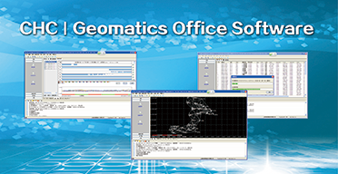
CHC announced today the availability of CHC Geomatics Office (CGO), a software solution dedicated to post processing static and kinematic GNSS raw data. CGO supports GPS+GLONASS+BeiDou data in various raw data formats and is compatible with major brands, allowing a seamless integration with an existing pool of equipment, the company said.
“CGO is undoubtedly the most affordable yet powerful GNSS post processing software available in the market.” says George Zhao, CEO of CHC. “In addition, this new product launch reinforces our commitment to provide full GNSS solutions to our customers including post-processing applications.”
A 90-day fully functional demonstration license is available to enable users to evaluate the CGO’s features before purchasing.
CHC designs, manufactures and markets a wide range of professional GPS/GNSS solutions in more than 50 countries. Headquartered in Shanghai (China), CHC is a GPS/GNSS manufacturer with a strong international presence and employs more than 500 professionals worldwide.
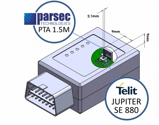
Telit Wireless Solutions and Parsec Technologies today announced that a combination of the companies’ technologies results in a low profile companion solution for GPS receiver and antenna. For host devices able to accommodate higher volumetric symmetry, assembly of the components can be made to fit a 6 x 16 x 8 millimeter volume. A flat component arrangement can yield an ultra-low-profile volume of 6 x 16 x 2.4 millimeters.
“Receivers combining the Parsec PTA/PT Family and Telit’s Jupiter SE880 modules deliver good user experience in finished LBS (location-based services) critical products without sacrificing design flexibility, ease of implementation or cost,” said Michael A. Neenan, CEO and founder of Parsec Technologies, Inc. “The combination is ‘bullet-proof’ in providing a rewarding design experience making RF work reliably, passing end-product regulatory compliance testing without re-test.”
“Miniaturization is a major enabler of new application areas for positioning and M2M,” said Taneli Tuurnala, Vice President and Head of GNSS Division of Telit Wireless Solutions. “With the Parsec antennas, the complete receiver features the industry’s ‘smallest landed footprint,’ making it suitable for use in wearable electronics, UBI devices or adapters for the mobile computing industry.”
Along with miniaturization, the receiver outperforms top traditional designs, handling a loss of 10 dB or greater in GPS signal reaching, for example, the typical OBD port under a vehicle’s dashboard where many usage-based insurance (UBI) dataloggers are installed. The PTA1.5M active antenna delivers the ultra-sensitive Jupiter SE880 micro receiver over 15 dB of additional gain in the operating frequency range. Both companies are making available complete application notes to simplify the engineering effort for system integrators.
The miniature 4.7 x 4.7 millimeter LGA (Land Grid Array), SiRFstarIV-based Jupiter SE880 receiver module employs heterogeneous 3D integrated technology to achieve best-in-class performance in all dimensions critical for regular or size-constrained GPS applications. Its RF front-end employs spatially calibrated waveguide-quality radio paths inside the three-dimensional space of its architecture, reducing parasitic impedances characteristic of traditional 2-D RF designs. Inside, a multi-filter system includes not only the traditional SAW filters typical in GPS receiver designs but also a 2.4-GHz notch-filter capable of nullifying the jamming effects of high-energy radio devices such as Wi-Fi hot-spots, Bluetooth systems, cordless phones, and others, which greatly affect a GPS receiver’s ability to resolve timid satellite signals in the hostile radio environment where they need to operate.
The PTA1.5M, with a gain of 15dB, and PTA1.5x2M, with a gain of 30dB, are tiny GNSS active antenna modules capable of receiving signals down to -192 dBm with frequency centered at 1575.42 (±1.023) MHz. Either model delivers a radiated efficiency greater than 60% when mated to the Jupiter SE880 receiver. Parsec’s PT1233D LNA also has the highest available IP3 at low voltage, helping eliminate interference. Both PTA1.5M and PTA1.5x2M can incorporate the antenna element, an optional SAW filter, the cascadable PT1233D LNA, matching and passives components, on a low cost, easy to integrate 10×16 mm single sided PCBA with “back side” copper clad ground plane. The height of the PTA1.5M and PTA1.5x2M modules vary according to application, allowing their use in even the smallest form factors including Intel’s M.2 Next Generation Form Factor (NGFF) module (23x30x2.4 mm, LxWxH).