The new Hemisphere GNSS logo uses only the word Hemisphere.
Today, Hemisphere GNSS introduced its new “Hemisphere” corporate branding and logo to reflect its global GNSS focus. The company is also announcing a new website that has been built from the ground up based on customer and partner input.
In February 2013, Hemisphere GPS was renamed and incorporated as Hemisphere GNSS Inc. The company owns both names, but in order to reflect the company’s support of all Global Navigation Satellite Systems (GNSS) and update the company image, Hemisphere GNSS Inc. will be adopting the use of the new “Hemisphere” logo.
“We are pleased to have completed our transition from a GPS agriculture-focused organization to a truly global GNSS Technology and Applications company. Today we are reaffirming our commitment to offering the best value in GNSS OEM boards, antennas, marine positioning, survey, mapping, and machine control products,” said Phil Gabriel, president at Hemisphere GNSS. “We are now introducing our new stylized globe logo and our updated branding to simply read ‘Hemisphere,’ as well as our new website and URL; www.HemisphereGNSS.com.”
The new website is easier to navigate and will assist customers in finding the information they need in a shorter amount of time, the company said. Employee email addresses are also being updated to first name initial, last name @HemisphereGNSS.com, though old email addresses will continue to work for the foreseeable future.
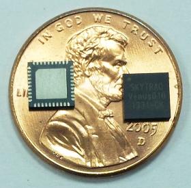
SkyTraq Technology Inc., a fabless GNSS positioning technology company, today introduced highly integrated Venus816 single-chip GPS receiver capable of supporting dual passive antenna and active antenna inputs, automatic switching from passive antenna to active antenna, and active antenna short circuit protection without needing extra external components. It offers low BOM cost for antenna-embedded GPS products needing external active antenna option.
The Venus816 includes two RF inputs with integrated antenna switching and external active-antenna current detection. A high-linearity on-chip 20dB gain 0.9dB noise figure LNA is used with one of the inputs, offering cascaded system noise figure of 1.2dB, allowing Venus816 to be used with passive antenna without the need for additional external LNA device.
The Venus816 works with GPS, QZSS, and SBAS signals, features industry leading 40Hz update rate, 29sec cold start TTFF, -148dBm cold start sensitivity, -165dBm tracking sensitivity, multipath suppression, jamming mitigation and reporting.
It is comes in 5mm x 5mm QFN40 package. A minimum of 6 external components is needed to form a working GPS receiver.
Venus816 engineering sample, evaluation kit, datasheet and reference design are available in late of October; mass production begins in November.
With its recent Ingress Protection (IP) certification, the Leica Zeno GG03 SmartAntenna is now an IP68-certified SmartAntenna for GIS applications. IP68 represents the top rating for protection against dust, moisture and water. Meeting the tough standards for Ingress Protection (IP) makes the Leica Zeno GG03 a rugged GNSS SmartAntenna for GIS asset collection and management tasks.
The upgradable Leica Zeno GG03 SmartAntenna is designed for organizations that require a compact and lightweight device for accurate and reliable positioning. The robust design of the Zeno GG03 brings further advantages when collecting GIS assets by offering reliable and rugged operation in extreme environments, even after continued exposure to water and dust.
“The Leica Zeno GIS series is used all over the world in the most demanding environments,” said Product Manager Johannes Hotz. “The IP68 rating further underlines the quality and robustness of the Leica Zeno GG03. The industry-leading GNSS performance and an unmatched ultra-rugged design is a big win for our customers in the field.”
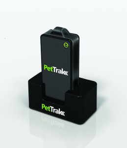
eTrak has announced the release of its latest product, the PetTrak GPS+ tracking system. Now available for purchase online, PetTrak is a small, lightweight device used to track the location of most pets.
PetTrak uses GPS+, eTrak’s patent-pending technology utilizing Wi-Fi, Cell ID, and GPS to deliver accurate location, indoors or out. Users will be able to utilize PetTrak to always know the location of their animal companions. PetTrak also allows users to set up specific safety circle zones, around designated areas where pets spend most of their time. If the pet leaves or enters this zone, the pet’s owner will be notified via text or email.
“One of the best features of PetTrak is the safety circle, which enables pet owners to draw a boundary circle around the house, yard, or any place that provides a protective perimeter for a pet,” said John Harris, eTrak founder and CEO. “If a pet wanders off beyond the circle, PetTrak will send an email and text message to the owner’s cellphone and computer. Not only that, but it will even include a Google map with the pet’s location.”
The PetTrak device can be attached to Simply attached to a pet’s collar. The animal can then be tracked in virtually any environment around the clock, from any smartphone, computer or tablet. With more than six million pets lost every year, PetTrak is designed to help owners rest assured knowing their furry friends are safe.
Research and Markets has issued a new precision farming technology report. According to the report, the growth of the market is expected to be remarkable, and is estimated to reach $3.72 million by 2018, at an estimated CAGR of 13.36% from 2013 to 2018. The major players in this industry are Deere & Co. (U.S.), Trimble Navigation (U.S.), Topcon positioning systems (U.S.), Raven Industries (U.S.), Precision Planting (U.S.), and AGCO (U.S.).
The major drivers for this market are augmented yield and profitability, energy and cost saving, and government assistance. Major restraints such as high initial investments and lack of awareness and their impact analysis are also covered under this study. North America currently leads the market share for precision farming as this region has the maximum adoption. Asia-Pacific (APAC) is the emerging market for precision framing and has been enjoying the highest growth rate among all the geographic regions. It is believed that the APAC market will grow at a CAGR of 25.16% from 2013 to 2018.
The full title is “Precision Farming Market by Technology (GPS/GNSS, GIS, Remote Sensing & VRT), Components (Automation & Control, Sensors, FMS), Applications (Yield Monitoring, VRA, Mapping, Soil Monitoring, Scouting) – Global Forecast & Analysis (2013 – 2018).”
The report covers all the technologies, components, and applications of precision farming; it provides a detailed analysis of the current market scenario and estimation for the next five years. Major applications like field mapping and yield monitoring are driving the market. Moreover, the market is driven by important technologies like GPS and variable rate technologies. This market is already progressing well in developed countries and it is also expected to grow well in the developing nations as a result of their ever growing food demands.
This study describes the value chain for precision framing market by considering all the major stakeholders in the market, and their role analysis. The report also performs a detailed scrutiny of the Porter’s five force analysis for the market. All the five major factors in these markets have been quantified using the internal key parameters governing each of them.
Key Topics Covered:
1 Introduction
2 Executive Summary
3 Cover Story
4 Market Overview
5 Global Precision Farming Market By Technology
6 Global Precision Farming Market By Hardware & Software Components
7 Precision Farming Market by Application
8 Global Precision Farming Market By Geography
9 Competitive Landscape
10 Company Profile – Overview, Products And Services, Financials, Strategy & Development
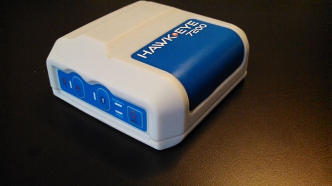
Blue Sky Network’s HawkEye 7200 Portable M2M Tracking Solution.
Blue Sky Network, a supplier of satellite tracking and communication solutions for aviation, land and marine, has launched the HawkEye 7200 portable M2M tracking solution. The HawkEye 7200 includes features such as multinational GNSS receiver support and integrated Bluetooth for Iridium connectivity to smart devices. Designed in a small form factor, the HawkEye 7200 can be powered by battery or via an external power source and is a key addition to Blue Sky Network’s solutions portfolio extending the reach of smart device communications globally anywhere in the world.
The HawkEye 7200 is Blue Sky Network’s first product to incorporate a multinational GNSS receiver. It combines the major GNSS providers into a single location-based chip that can be used in other parts of the world including GLONASS for Russia and the Galileo for the European Union. This multinational GNSS receiver feature enables fleet operators with globally dispersed assets to obtain position reports with increased accuracy and performance. When used with New SkyRouter, Blue Sky Network’s cloud-based web-portal, the HawkEye 7200 offers portable tracking and resource management of any asset type across the globe. The HawkEye 7200 hosts an RS232 interface and digital inputs/outputs for connectivity and control of external sensors or other telematics devices.
With the integrated Bluetooth connectivity, the HawkEye 7200 supports Blue Sky Network’s new iPhone/iPad application. The application allows users to send emails, short-code messages and customizable electronic forms through the Iridium network. With the ability for operators to build and fully customize forms — such as flight plans, maintenance records and logistic records of remote assets — HawkEye 7200 supports the industry’s movement toward paperless fleet operations.
“Blue Sky Network is a long-time member of the Iridium partner ecosystem and is continuously delivering cutting-edge M2M communication solutions targeting new markets,” said Bryan Hartin, executive vice president, commercial sales and marketing of Iridium. “The HawkEye 7200 is yet another solution from Blue Sky Network that offers powerful capabilities and applications that utilize the Iridium network. Together we are providing customers with critical connectivity worldwide.”
“The HawkEye 7200 further bolsters our leadership position in the mobile resource management and tracking industry,” said Blue Sky Network’s CEO and founder, Jon Gilbert. “Combining our HawkEye 7200 with our iPhone/iPad application and our industry-leading backend web portal, New SkyRouter, our customers have a complete end-to-end solution to link the far reaches of the world right in the palm of their hand. We are shrinking the global communication barrier and improving the methods by which people anywhere make connections to manage critical assets and communicate.”
Blue Sky Network is showcasing the HawkEye 7200 at the Helitech International Helicopter Expo & Conference, in London on September 24-26, in booth #B59.
The new HawkEye 7200 is in process of being certified by Iridium, with production expected in Q4 2013.
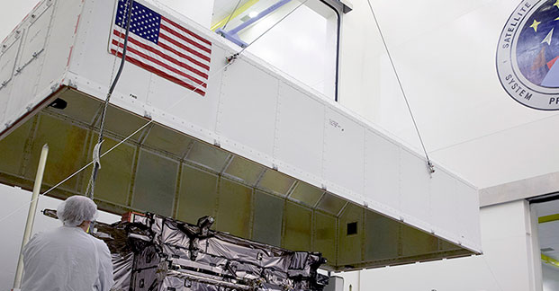
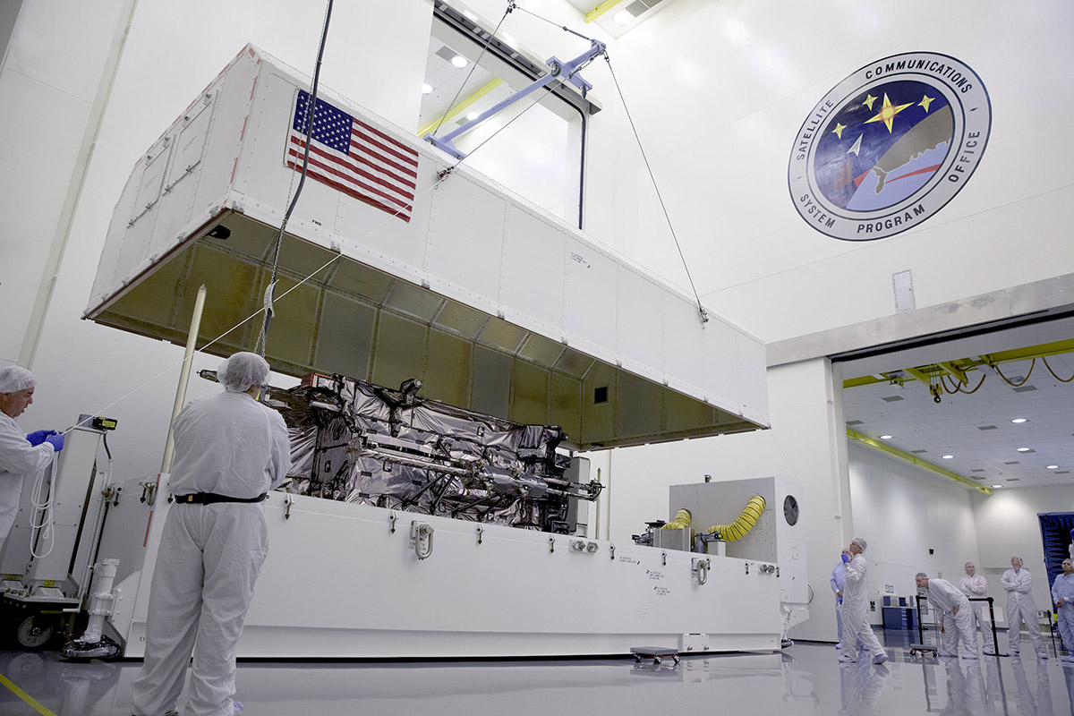
During the August test, the GPS III Non-flight Satellite Testbed (GNST) proved that it could connect with and receive commands from the Launch and Check Out System.
The prototype for Lockheed Martin ‘s next generation GPS III satellite reached a major milestone on August 30 when it successfully established remote connectivity and communicated with the GPS Next Generation Operational Control System (OCX), being developed by Raytheon, during a series of pre-flight tests.
During the Compatibility and Integration (C&I) Tests, Lockheed Martin’s GPS III Non-flight Satellite Testbed (GNST) — a full-sized, functional satellite prototype currently residing at Cape Canaveral Air Force Station — proved that it could connect with and receive commands from Raytheon’s Launch and Check Out System (LCS), part of the next-generation OCX that supports the satellite and mitigates risks prior to launch.
The GNST received commands from the LCC node at Lockheed Martin’s facility in Newtown, Pennsylvania, via the OCX servers at Raytheon’s facility in Aurora, CO, the system then returned satellite telemetry to the control station. The tests mirror launch and early orbit testing planned for all flight vehicles.
“The GNST is essentially a non-flying, functional GPS III satellite. While we have connected OCX with ground-based simulators before, these C&I tests were the first time that OCX and a GPS III satellite have actually communicated,” explained Keoki Jackson, vice president for Lockheed Martin’s Navigation Systems mission area.
Matthew Gilligan, a vice president with Raytheon’s Intelligence, Information and Services business and Raytheon’s GPS OCX program manager, stated, “This was an invaluable early opportunity to demonstrate command and control of the GPS III satellite with LCS, proving the end-to-end system capabilities well before putting an actual GPS III in orbit. The positive results tell us that we are right on track for the first GPS III launch.”
The LCS works hand-in-hand with Lockheed Martin’s Launch and Checkout Capability (LCC) contract, which brings online some of OCX’s GPS III-specific capabilities early to provide on-orbit checkout and control of the satellites.
The GNST has been at the Cape since July dry-running launch base space vehicle processing activities and pre-launch testing that all future flight GPS III satellites will undergo. The first flight GPS III space vehicle (SV-01) is expected to be available for launch in 2014, and launched by the U.S. Air Force in 2015.
Prior to shipment to the Cape, the GNST was developed and then completed a series of high-fidelity activities to reduce program risks, improve efficiencies and pathfind the integration, test and environmental checkout that all production GPS III satellites undergo at Lockheed Martin’s new GPS III Processing Facility in Denver, Colo.
An innovative investment by the Air Force under the original GPS III development contract, the GNST has helped to identify and resolve development issues prior to integration and test of SV-01. Following the Air Force’s rigorous “Back-to-Basics” acquisition approach, the GNST has gone through the development, test and production process for the GPS III program first, significantly reducing risk for the flight vehicles, improving production predictability, increasing mission assurance and lowering overall program costs.
The Lockheed Martin-developed GPS III satellites and Raytheon’s OCX are critical elements of the U.S. Air Force’s effort to modernize the GPS enterprise more affordably while improving capabilities to meet the evolving demands of military, commercial and civilian users worldwide.
GPS III satellites will deliver three times better accuracy; provide up to eight times more powerful anti-jamming capabilities; and include enhancements which extend spacecraft life 25 percent further than the prior GPS block. The GPS III also will carry a new civil signal designed to be interoperable with other international global navigation satellite systems, enhancing civilian user connectivity. The spacecraft bus and antenna assemblies for the first GPS III satellite have been delivered to Lockheed Martin’s GPS III Processing Facility and are in the integration and test flow leading to the planned space vehicle delivery in 2014.
Lockheed Martin is currently under contract for production of the first four GPS III satellites (SV 01-04), and has received advanced procurement funding for long-lead components for the fifth, sixth, seventh and eighth satellites (SV 05-08).
OCX will revolutionize GPS command and control and mission management capabilities, controlling all legacy and new military and civil signals, providing protection against evolving cyber threats and ensuring continuity of operations during cyber attacks, and reducing operation and sustainment costs through efficient software architecture, automation and performance-based logistics. OCX represents a quantum leap in capabilities over the current Operational Control System and provides flexibility and adaptability to meet future GPS mission needs. Raytheon is the OCX prime contractor and is on track to deliver the final Launch and Checkout System in 2014.
The GPS III team is led by the Global Positioning Systems Directorate at the U.S. Air Force Space and Missile Systems Center. Lockheed Martin is the GPS III prime contractor with teammates ITT Exelis, General Dynamics, Infinity Systems Engineering, Honeywell, ATK and other subcontractors. Raytheon is the GPS OCX prime contractor with teammates ITT Exelis, Boeing, Braxton, Infinity Systems Engineering, and NASA’s Jet Propulsion Laboratory. Air Force Space Command’s 2nd Space Operations Squadron (2SOPS), based at Schriever Air Force Base, Colo., manages and operates the GPS constellation for both civil and military users.
Kongsberg Seatex has given users of the eBird System the ability to equip SmartWing instrumentation with two additional features — a compass and a GNSS receiver. eBird is a bird concept for lateral, vertical and roll streamer control in marine seismic acquisition that enables fault tolerant and efficient multi-streamer steering by employing a wide range of innovative and patented technological solutions.
The innovative approach of placing a GNSS receiver in the wings opens new opportunities for improving the efficiency of an operation – in particular during launch and recovery but also when running lines.
The built-in GNSS receiver has been implemented based on Kongsberg Seatex’ extensive competence within GNSS technology. Transmission of satellite data from the seismic vessel to eBird reduces the time to first position fix considerably – giving eBird a position with one wing semi-surfaced. The built-in compass has been developed based on Kongsberg Seatex’ deep knowledge and experience within sensor technology and is fully integrated with SmartWing. The compass provides heading information from a submerged eBird.
These add-ons represent further improvements to the eBird streamer positioning and control concept.
“We always try to find improvements to our solutions and these new features are excellent examples of how we combine our core technology and expertise to create improved value for our customers,” says Gard Ueland, President of Kongsberg Seatex AS. “This is one step further in our offering to the seismic market, and we will continue to improve our solutions in close cooperation with our customers.”
eBird has, since its introduction at SEG in 2009, gained high attention within the seismic acquisition community with its sleek and functional design and utilisation of innovative technology together with proven performance in large seismic streamer spreads.
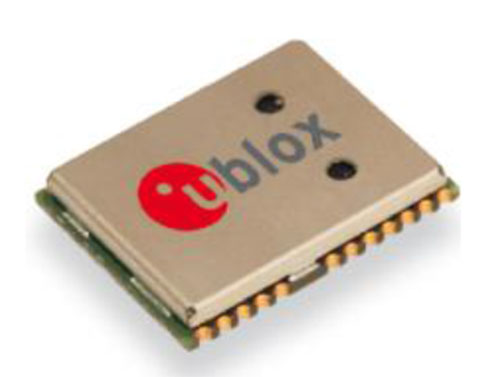
The NEO-7P sub-meter GPS positioning module with Precise Point Positioning (PPP) and Differential GPS.
Swiss-based u‑blox has introduced the NEO-7P, an improved, low-power, compact, high-precision GPS module. While remaining backwards compatible with its predecessor NEO-6P, the new module achieves standalone sub-meter precision based on single-frequency precise point positioning (PPP) technology.
Fully autonomous sub-meter performance can be realized for most outdoor applications within coverage of Satellite Based Augmentation Systems (SBAS) throughout North America (WAAS), Europe (EGNOS), and Japan (MSAS).
In areas where SBAS is unavailable, the NEO-7P achieves high-accuracy based on Differential GPS (DGPS) positioning as an alternative to PPP. DGPS uses RTCM correction messages (correctional data defined by the Radio Technical Commission for Maritime Services) from a local reference station or aiding network to cancel out measurement error introduced by atmospheric distortion and variances in satellite orbits and clocks.
“The NEO-7P addresses many requirements for precise positioning used in surveying, mapping, marine, and clear-sky recreational applications,” said Thomas Nigg, VP product marketing at u-blox. “The solution delivers sub-meter positioning performance based on two techniques at a fraction of the cost of other high precision solutions. The solution is compact, requires no external base station, and uses a single frequency receiver.”
The device comes in u-blox’ compact NEO Leadless Chip Carrier (LCC) module form factor. A UART, USB and I2C interface provide flexible connections to a host processor. It can also communicate directly with u‑blox’ SARA 2G, LISA 3G and TOBY LTE cellular modules.
The NEO-7P also provides complete GPS satellite raw data allowing further accuracy improvement based on post processing by an external host. Internal Flash memory allows simple firmware upgrades. The NEO-7P also supports Russian GLONASS Japanese QZSS positioning standards.
The module is suitable for vehicle, industrial and consumer applications.
Detailed information about the NEO-7P can be found on the u-blox website.
Sponsored by:Hemisphere GNSS
Original Broadcast Date: Thursday, September 19, 2013 Moderator: Janice Partyka, Wireless LBS Insider editor Speakers: David Jumpa, Chief Revenue Officer, Airbiquity;Scott McCormick, President, Connected Vehicle Trade Association; Andrew Maliszewski, Executive VP, Micronet;Scott Sedlik, VP Product and Marketing, Inrix Summary: The biggest announcements and the most interesting news at the three big wireless/electronics shows in 2013 have all concerned the connected car. Location is a core technology. How will the connected vehicle market evolve? Will there be similarities to the more advanced fleet market? Providers of navigation, mapping, traffic, middleware, search, points of interest and mobile advertising all have key roles to play. How will the complexity of personalization and extras make it difficult to deliver products and service? The pace will only accelerate. Sort through the multiple issues and get your roadmap to the future with Janice Partyka and a panel of industry experts.
JAVAD GNSS has launched a new version of the TRIUMPH GNSS receiver, which features 864 channels — more than any receiver it has yet offered. The TRIUMPH-LS land survey receiver offers, in addition to the 864 GNSS channels, three powerful processors, 256 I/O, 24 digital filters, 24 anti-jam filters and 14-MB program memory all in a single chip, which uses less power and makes the total system less expensive, according to the company.
The announcement was made at the ION GNSS+ Conference, being held this week in Nashville, Tennessee.
Javad Ashjaee, CEO and founder, explained the decision to incorporate 864 channels. “Some questioned the need for the 216 channels. They now realize the need for 440 channels. We assign multiple channels to each satellite for redundancy and reliability. We use more than 100 channels to scan GNSS bands for interference — 864 channels is the key to reliable performance.”
The TRIUMPH-LS provides visual stake-out, six parallel RTK engines, more than 3,000 coordinate conversions, advanced coordinate geometry features, and rich attribute tagging on a high-resolution 800 x 480 pixel display. When used in photogrammetry, offsets can be calculated using the internal camera for 10-centimeter accuracy, or an external camera for 5-centimenter accuracy. TRIUMPH-LS is the first JAVAD GNSS receiver to offer photogrammetry for land survey.
Other features include versatile attribute tagging, feature coding, automatic photo and voice documentation, and an interference monitoring and reporting feature.
The TRIUMPH-LS has a battery life of 25 hours in RTK rover mode with full screen brightness and UHF/GSM. Two hours of charge equals two days of surveying. The internal batteries are field serviceable and can be easily replaced by the user when needed.
The TRIUMPH-LS, including batteries and pole, is the lightest GNSS RTK receiver in its class, according to JAVAD GNSS. The total weight of the system — including radio, controller, pole and 25 hours of internal battery — is 2.5 kilograms.
Built on a tough magnesium alloy chassis, all connectors, SIM cards, and micro-SD cards are protected against harsh environmental conditions. The pole can be collapsed and the unit can easily fit in a car seat — there are no long poles and no separate controller or brackets to disassemble.
The TRIUMPH-LS automatically updates all firmware when connected to the Internet via Wi-Fi. The built-in GNSS full tracking antenna has a large ground place and excellent centering and rotational performance.
To learn more about the TRIUMPH-LS, stop by the JAVAD GNSS booth (Booth D) in the ION GNSS+ Exhibit Hall now through Friday.Presentation will be given Thursday at the conference room of the exhibition hall at 2:00 pm.
The collaborative solution will be launched commercially later in 2013, and was previewed at ION GNSS+ in September in Nashville, Tennessee.
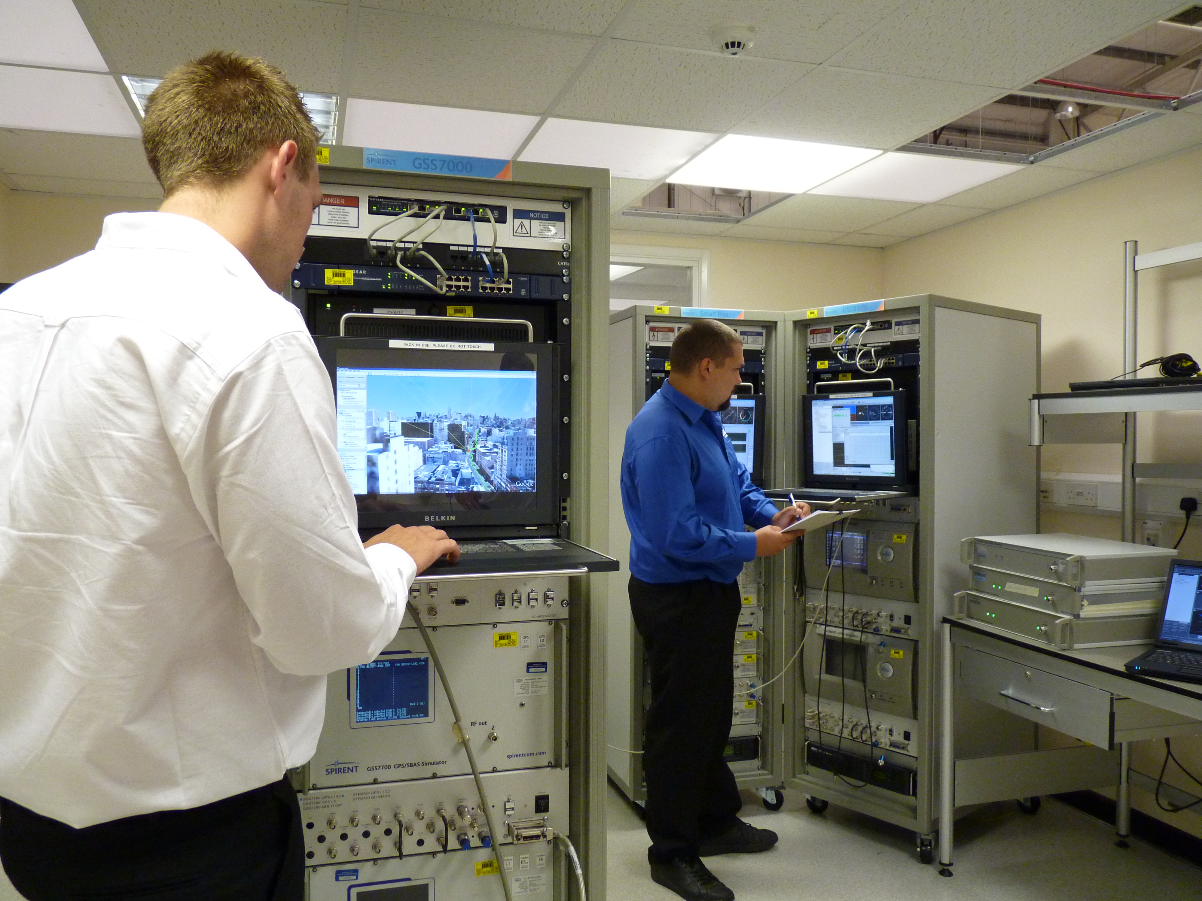
The test bed will concurrently simulate legitimate GNSS constellations and spoofed or hoax signals. It will enable positioning systems manufacturers to improve their products’ resilience to hoax signals.
As GNSS becomes increasingly embedded in modern infrastructure for application timing and device positioning, the impact of spoofing attacks becomes greater. From mobile telephony to Internet banking, GNSS timing signals are used in many key systems, and yet there is no requirement on GNSS equipment to demonstrate any degree of robustness to block or even detect malicious attacks that disrupt performance.
“There is growing industry concern about the vulnerability of satellite navigation signals,” said John Pottle, Marketing Director of Spirent’s Positioning Division. “This will help the industry to create positioning systems that are more resilient to interference.”
Hoax or spoofing attacks work by mimicking genuine GNSS signals, which mislead GNSS receivers. Often affected receivers do not recognize when they are receiving fake signals and continue to operate normally, but provide false time or position information. This new test tool helps to develop systems that will detect and counter spoofing attacks by providing a fully controllable laboratory based, non-radiated test solution to evaluate a receiver’s response to a range of spoofing attacks. The test tool controls the emulation of signals representing both the genuine GNSS signals and the false signals. This allows users to simulate a wide range of sophisticated attacks and monitor the response of the receiver under attack to then improve the resilience of the design against such attacks.
For more information on threat detection and mitigation testing visit Spirent Booth #F during ION GNSS+, September 15-20 in Nashville, Tennessee.