The Esri Mobile team announced it has released an update to the ArcGIS for Android app.
There are several key bug fixes and enhancements that improve app stability (NIM084516, NIM084565), support for an on-premises Portal, and secured services (NIM84775).
Update: Elon Musk, SpaceX’s CEO and chief designer, has posted an update on the status of the upcoming Falcon 9 launch on his Twitter account. “Will do another static fire of rocket to make sure all is good & AF [[Air Force]] needs to test ICBMs, so probable launch Sept 29/30,” Musk tweeted.
“The static fire is scheduled for later this week, perhaps Wednesday, sources said. It will retest the Falcon 9 rocket after several problems cropped up during a hotfire of the launcher’s engines Thursday at Vandenberg Air Force Base, Calif.
“The U.S. Air Force Western Range, which controls a network of tracking and communications assets based at Vandenberg, is busy for the next few weeks due to Minuteman ballistic missile testing.”
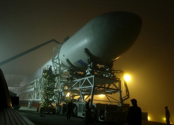
The Falcon 9 rocket, with CASSIOPE inside its fairing, on the way to the launch pad at Vandenberg Air Force Base. (Photo credit: SpaceX).
A GPS instrument designed by University of New Brunswick scientists is scheduled to be launched into space aboard the SpaceX Falcon 9 rocket on September 15. The rocket will depart Vandenberg Air Force base in California as part of the CASSIOPE (Cascade Smallsat and Ionospheric Polar Explorer) mission.
Dr. Richard Langley, GPS World Innovation editor and professor in geodesy and geomatics engineering at the University of New Brunswick, is a principal investigator behind the scientific portion of the CASSIOPE mission. Langley and his colleagues will monitor data from the GPS instrument, which is part of the Enhanced Polar Outflow Probe (e-POP) payload aboard the spacecraft.
E-POP will continue the sequence of Canada’s orbiting space environment sensors, which began with Canada’s first satellite, Alouette 1, launched in 1962 to study the ionosphere. e-POP is, perhaps, the most extensive suite of sensors for studying the ionosphere/magnetosphere/thermosphere yet to be launched, and will provide Canadian and other scientists with the opportunity to better understand the impact and variability the sun has on the space environment — what we call “space weather.”
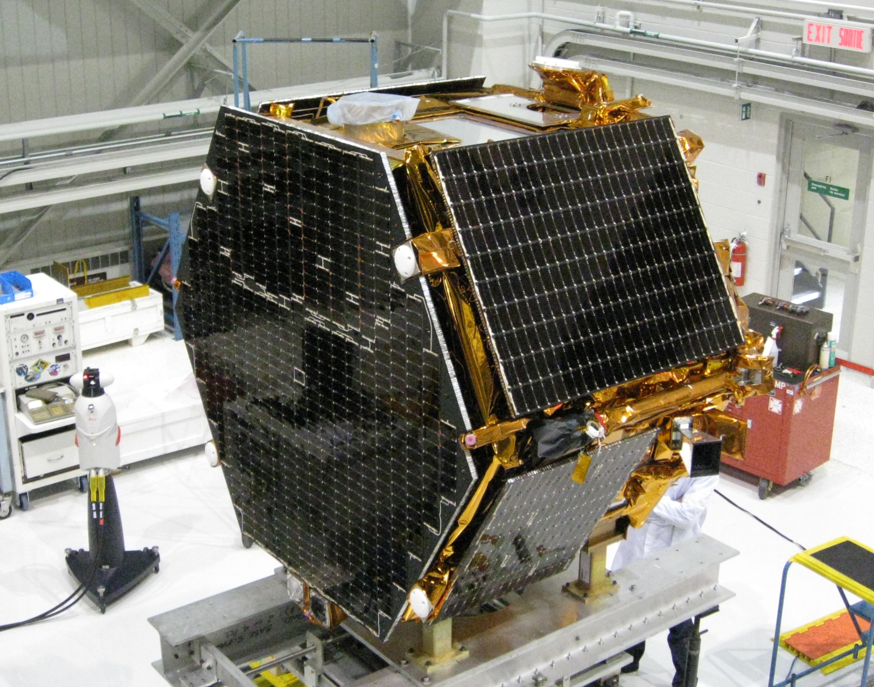
The research satellite CASSIOPE on a test platform at the Canadian Space Agency’s David Florida Laboratory. CASSIOPE hosts the GPS Attitude, Positioning, and Profiling instrument designed by GGE researchers. The four white antennas on the left-facing side of the spacecraft will be used to determine the position, velocity, and attitude of the spacecraft while the antenna on the upper side will be used to profile the ionosphere’s electron density. (Photograph courtesy of MacDonald, Dettwiler and Associates Ltd.)
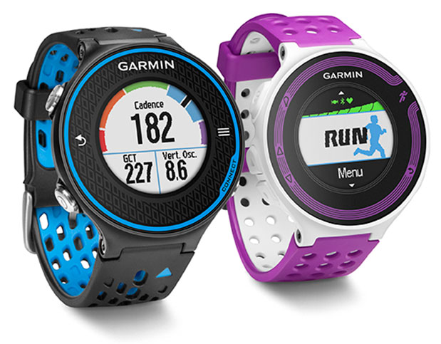
Garmin International Inc., a unit of Garmin Ltd., the global leader in satellite navigation, is now offering the Forerunner 620 and Forerunner 220 GPS running watches, both of which have color displays. The Forerunner 620 offers advanced features like recovery advisor, race predictor and VO2 max (maximal oxygen uptake) estimate to help runners train and achieve race goals. When used with the new HRM-Run (heart rate) monitor, the 620 also provides feedback on running form.
For indoor training, such as on a treadmill, the 620 and 220’s built-in accelerometer tracks distance and pace, so runners don’t need a separate sensor. Both models boast Garmin’s unique one-inch Chroma color display to easily interpret data.
“Whether running indoors or out, Forerunner 620 and 220 will change the way runners look at training,” said Dan Bartel, Garmin vice president of worldwide sales. “Advanced features in the 620 such as recovery advisor, VO2 max estimate, race predictor and stats on running economy, combined with connected features and training plan options found in both the 620 and 220, make these watches must haves for runners of all levels. To keep runners motivated the watches also notice if runners hit any personal records on that run, like their fastest mile, 5k, 10k, half or full marathon or their longest run to date.”
Regardless of a runner’s experience, motivation, or how far or fast they go, they likely want to know how they can improve and objectively measure their fitness. Forerunner 620 does just that by estimating runners’ VO2 max, which is a good indicator of athletic capability. Previously, the only way to accurately obtain VO2 max was by paying for a lab test.
When used with a heart rate monitor, the 620 incorporates several pieces of data, like running speed, beats per minute and heart rate variability, into an advanced algorithm to estimate runners’ VO2 max. The number itself indicates the maximum volume of oxygen a runner can consume per minute, per kilogram of body weight at their max performance. Theoretically, the more oxygen runners can use during high-level exercise, the more energy they can produce. A color gauge on the watch display shows how a runner’s VO2 max data compares to other individuals of their gender and age range. Based on the VO2 max estimate, the 620 can predict a runner’s race time for several distances. This can give runners a time target for their next race, assuming they’ve completed proper training.
When wearing HRM-Run, Forerunner 620’s recovery advisor and recovery check take the guesswork out when it comes to planning recovery time between hard workouts. Just like a coach, it learns the runner and their physiology based on heart rate data, so it factors this against their last workout and then shows how much time before they are fully recovered and ready for their next hard running workout. Color-coding on the high-resolution Chroma display gauge makes it easy to interpret — green means they are good to go. When runners see red on the display and a recovery time of more than three days, they might consider taking a rest day or just doing a light recovery run.
HRM-Run also has an accelerometer in the module that measures torso movement in order to calculate 3 different running metrics:
Cadence — the number of steps per minute. It displays the total steps (right and left combined)
Vertical oscillation — the bounce in runners’ running motion. It displays the vertical motion of a runners’ torso, measured in centimeters.
Ground contact time — the amount of time in each step that you spend on the ground while running, measured in milliseconds.
Thanks to their Bluetooth Smart wireless upload capabilities, Forerunner 620 and 220 can send runners’ run data to the Garmin online community, Garmin Connect, without being connected to a computer. It can transfer the data through the Garmin Connect Mobile app on their compatible smartphone. Additional connected features include live tracking, which allows runners’ friends and fans to follow along and see their stats in real-time. Runners must have their phone paired with their 620 or 220 throughout the run to use the LiveTrack feature. Victories, goals achieved and successes can be shared on runners’ social media sites by posting updates through the Garmin Connect Mobile app.
With the growing popularity of the run/walk training method in the distance running community (example: a runner runs for five minutes, walks for one minute and repeats for the duration of the course), Garmin has included a run/walk alert. This alert allows Forerunner 620 and 220’s other features, such as, Auto Lap and Auto Pause, to remain active during a run/walk session.
Both Forerunner 620 and 220 are water-resistant to 50m and can stand up to much more than rain, sweat and splashes. The Forerunner 620 has a touchscreen display responsive enough that it can be operated with running gloves, while the 220 is operated with easy to push buttons. Both models have rechargeable batteries lasting up to six weeks in watch mode and up to 10 hours in training mode.
Answer a GNSS Trivia Question and Get in on the Musical Action
Got the urge to sling notes likes a Nashville country star? Come by GPS World’s booth (#116–#118) at ION GNSS+ for a look at the brand-new Fender Telecaster electric guitar — first prize in a random drawing of correct answers in a GNSS Trivia Contest.
One lucky winner will leave ION with this music legend under his or her arm. All you have to do is correctly answer One Question, such as:
What does DRMS stand for, in the GNSS community?
A. Data Record Management System
B. Decision, Risk, and Management Sciences
C. Defense Resource Management System
D. Distance Root Mean Square
Correct answers will go in one bin, incorrect answers in another. At 3:45 p.m. Thursday in the GPS World booth, during the afternoon coffee break on the exhibit floor, one winner will be drawn at random from each bin. The winner from the first bin gets the Telecaster guitar; the winner from the second bin gets two tickets to GPS World’s Leadership Dinner on Thursday evening.
All players must complete a subscription form to qualify for a free subscription to GPS World magazine, or one of eight different email newsletters, in order to play the Trivia Game.
Winners need not be present at the drawing to win — but must respond to an email or text alert, to come by the booth before 6 p.m. on Thursday to claim either prize.
The Telecaster, a dual-pickup, solid-body electric guitar made by Fender, revolutionized sound when it burst upon the scene in 1951, and has been in continuous production ever since. Guitarists from Jeff Beck to James Burton, not neglecting Keith Richards or Bruce Springsteen, have played on a Telecaster.
Chronos Technology, global timing and synchronization company, is exhibiting its anti-jamming technology at ION GNSS+ 2013 in Nashville, Tennessee, September 18-20.
Exhibiting at Stand 723, Chronos will be demonstrating the Chronos Sentinel system, which enables a light-touch deployment of GPS jamming detection for a short period of time and allows a GPS jamming report to be created to enable management to assess the threat.
The CTL3520 handheld GPS jamming detector by Chronos Technology.
Chronos will also be displaying various GPS products, including the new CTL3520 handheld GPS jamming detector and locator system aimed specifically at detecting GPS jammers hidden in vehicles. The unit can pinpoint even the weakest jammer and identify the vehicle in which the jammer is hidden, even in a busy multi-storey car park. Other applications include detecting vehicles with jammers at ports, fleet depots, airport car parks and taxi ranks.
In addition, Professor Charles Curry, managing director with Chronos Technology, is presenting a technical paper “GPS Jamming -Threat Scenarios” on Monday, September 16, at CGSIC, which precedes ION GNSS+ 2013.
For more information about ION GNSS+ 2013, visit www.ion.org
Symmetricom will be participating in a new products panel at ION GNSS+, which will be held September 16-20 in Nashville, Tennessee.
Phil Bourekas, Symmetricom executive vice president of marketing, will take part in “New Products Panel: Legacy and Expertise in GNSS Timing” on Thursday, September 19, 8:30 a.m. to 12:15 p.m. in Grand Ballroom East of the Nashville Convention Center, Nashville, Tennessee.
The presentation will focus on Symmetricom’s suite of GNSS-applicable timing products, ranging from precision time protocols to atomic clocks, and how they can be used by the government, communications, power and enterprise verticals.
Symmetricom is also a sponsor of the exhibitor-hosted reception. In its booth (#619), Symmetricom will exhibit and demonstrate the following products:
GPS Time & Frequency Receivers (XLi and XLi SAASM GB-GRAM models)
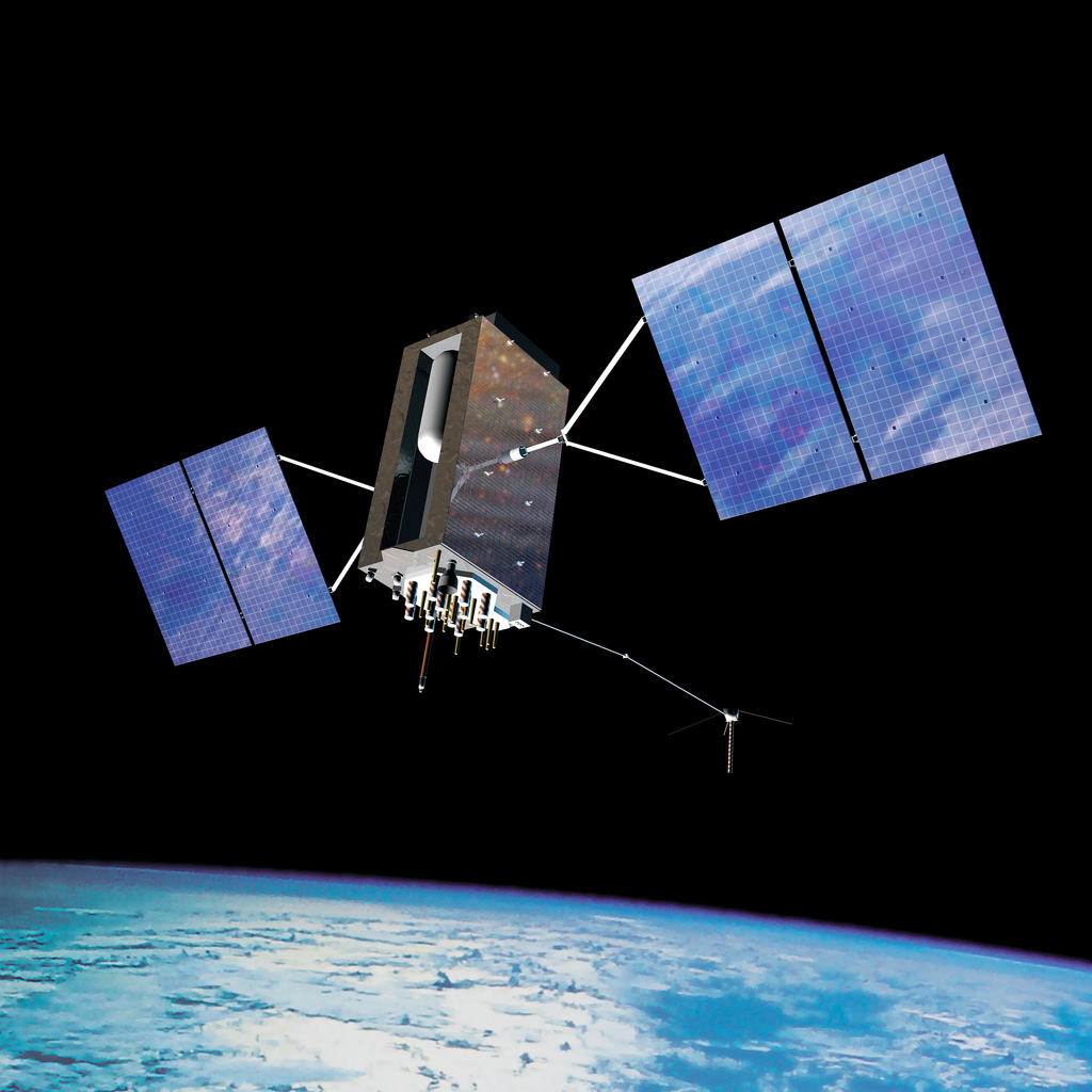
Artist’s concept of the nextgen GPS III satellite (courtesy of the USAF).
Lockheed Martin and Raytheon Company successfully completed the third of five planned launch and early orbit exercises to demonstrate the launch readiness of the world’s most powerful and accurate Global Positioning System (GPS), the U.S. Air Force’s next-generation GPS III satellite and Operational Control System (OCX).
Successful completion of Exercise 3, on August 1, was a key milestone demonstrating Raytheon’s OCX software meets mission requirements and is on track to support the launch of the first GPS III satellite, being produced by Lockheed Martin. Two additional readiness exercises and six 24/7 launch rehearsals are planned before launch of the first GPS III satellite in 2015.
Using new installments of Raytheon’s OCX software and Lockheed Martin’s GPS III Launch and Checkout Capability (LCC), the Air Force Global Positioning System Directorate and the industry team completed a launch and early orbit exercise over a three-day period in late July. Exercise 3 demonstrated space-ground communications; first acquisition and transfer orbit sequences; orbit-raising maneuver planning and execution; and basic anomaly detection and resolution capabilities. In addition, the industry and customer teams jointly executed mission planning activities, such as orbit determination and the generation of upload command files.
Exercise 3 expands on two previous exercises, with a longer mission timeline, and the introduction of simulated vehicle and ground anomalies to evaluate the combined response capabilities of the control segment, satellite and operations crew. “Successful completion of Exercise 3 clearly demonstrates that OCX is on track to support the first GPS III satellite launch,” stated Matt Gilligan, a vice president with Raytheon’s Intelligence, Information and Services business and Raytheon’s GPS OCX program manager. “The system responded as designed, and met all of the launch exercise success criteria and successfully demonstrated our anomaly response.”
“Exercise 3 demonstrated that the cross-organizational operations team is on track to support successful GPS III launch and on-orbit checkout missions from our Newtown facility,” said Keoki Jackson, vice president of Lockheed Martin’s Navigation Systems mission area. “I look forward to the team’s continued success as they progress through the complex mission readiness program towards the first GPS III launch.”
The Lockheed Martin-developed GPS III satellites and Raytheon‘s OCX are critical elements of the U.S. Air Force’s effort to modernize the GPS enterprise more affordably while improving capabilities to meet the evolving demands of military, commercial and civilian users worldwide.
GPS III satellites will deliver three times better accuracy; provide up to eight times more powerful anti-jamming capabilities; and include enhancements which extend spacecraft life 25 percent further than the prior GPS block. The GPS III also will carry a new civil signal designed to be interoperable with other international global navigation satellite systems, enhancing civilian user connectivity. The spacecraft bus and antenna assemblies for the first GPS III satellite have been delivered to Lockheed Martin’s GPS III Processing Facility and are in the integration and test flow leading to the planned space vehicle delivery in mid-2014.
OCX is being developed in two Blocks using a commercial best practice iterative software development process, with seven iterations in Block 1 and one iteration in Block 2. Exercise 3 was conducted using the recently completed Iteration 1.4 software. Exercise 4, scheduled for early 2014, will use Iteration 1.5 software, which includes the Launch and Checkout System capability as well as all critical information assurance features needed to support launch of the first GPS III satellite.
Despite the continued decline of PNDs, and the threat of smartphones, smart watches and eyewear, the portable GPS-enabled device market is forecast to continue to hold its own thanks to dedicated HUD/eyewear, cycling and health/tracking devices, according to a report by ABI Research.
ABI Research’s quarterly GNSS Database forecasts the new and emerging markets for GPS-enabled devices, and where the opportunities lie in terms of device formats and vertical markets. The report also considers the impact of competitive formats such as smartphone applications, wearable sensors, smart watches, and smart eyewear, providing a complete picture of drivers and inhibitors in this market.
Senior analyst Patrick Connolly comments, “The overall market is forecast to grow from 33.3 million units in 2012 to 36.79 million in 2018, following a brief dip in 2013 as PND declines outweigh growth in other areas. Total revenues will undergo a brief period of fluctuation from 2013 to 2015, before rising to $7.14 billion in 2018.”
Dominique Bonte adds, “The markets for cycling computers, health/elderly, and fitness are starting to get interesting. As ASPs decline and smart watches become a more established part of our lives, the addressable market will be eaten up, limiting the growth potential for dedicated fitness devices. Looking longer term, ABI Research has forecast very strong growth for HUD/eyewear devices, particularly in the fitness, golf, and cycling categories. It would not be surprising to see an acquisition in this space over the next 12 months.”
These findings are part of ABI Research’s Location Devices Research Service, which includes research analyses, market data, insights, and competitive assessments focused on the GPS/GNSS IC and devices markets.
Registration is now open for Munich Satellite Navigation Summit 2014, which will be held March 25-27, 2014, at the Residenz Muenchen in Munich, Germany.
The summit will have a booth (Booth H) in the exhibit hall at the ION GNSS+ conference next week in Nashville, Tennessee. The conference is offering a special ION rate for those who register no later than October 21.
The summit has been established as the European and International conference with global impact featuring invited high-ranking worldwide speakers from industry, science and governments dealing with the directions of satellite navigation now and in the future.
The summit starts on March 25 with the Exhibition Opening and Champagne Reception at 16.30 hrs. The technical programme of the conference starts with the Opening Plenary Panel discussing the topic “GNSS – New Challenges” at 17.15 hrs. Afterward, the Bavarian State Reception in the famous Residenz München provides opportunities for networking.
The technical program includes plenary discussions among invited speakers and presents a concise update on the main activities in worldwide satellite navigation systems, in particular:
Implementation of the European satellite navigation system Galileo
Modernization of the U.S. Global Positioning System (GPS IIF, GPS III)
Status and modernization of the Russian Global Satellite Navigation System GLONASS
Developments of new global and regional systems like the Chinese COMPASS, the Japanese QZSS and the Indian IRNSS
Space-Based Augmentation systems (SBAS)
Legal issues of privacy devices and GNSS re-transmitters
Getting the centimeter on global scale (Precise Point Positioning)
Design of future navigation systems: Will autonomous sensors come to the fore
GNSS monitoring of the system earth and natural disasters
Integrated applications of GNSS and Earth Observation
The Munich Satellite Navigation Summit will further highlight the creation of new applications and services in satellite navigation, in combination with telecommunication and information technology, in particular geo-information technology.
Various sessions will feature discussions among invited panellists talking about perspectives and critical issues in various rapidly growing application scenes of satellite navigation, in particular with Galileo. Brief presentations and statements of the panelists are initiating each session. An interactive question and answer period with the auditorium is closing the topic.
In 2014:
An exhibition for industry and institutions is taking place during the conference.
The European Satellite Navigation Master competition will be announced.
The summit includes a parallel track on Copernicus the European Commission’s Earth Observation Programme. Alongside technical and political updates, the sessions will also give insight into services and applications enabled by the programme.
The Summit is part of the efforts of the Bavarian government and the cluster on aerospace and satellite navigation to stimulate applications and services in this high-tech field.
For more information, contact +49-89-6004-3425 or e-mail [email protected].
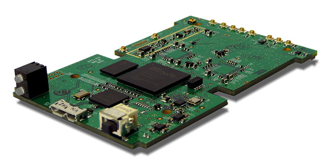
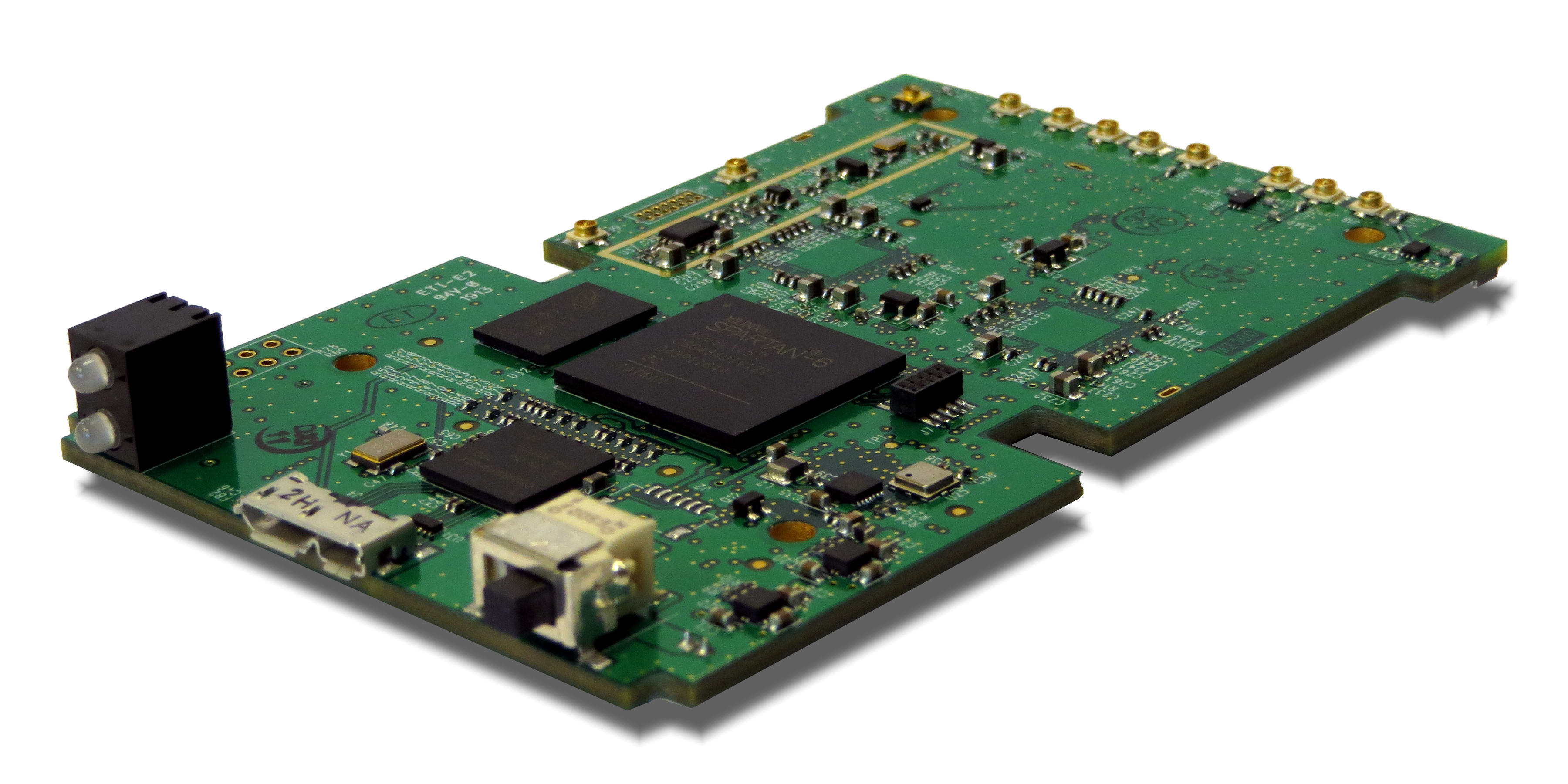
Loctronix Corporation, a provider of unified positioning solutions for GNSS-challenged environments, is making available its new software-defined radio (SDR) module, the ASR-2300, for developing high-performance positioning, navigation and timing, and communication applications.
The ASR-2300 will be on display September 16-19 at the Institute of Navigation annual meeting, ION GNSS+ 2013, in Nashville, Tennessee.
“The ASR-2300 delivers advanced SDR capabilities in a small, mobile form-factor enabling developers to readily create and field complex SDR-based solutions. The module moves SDR out of the lab and into production, providing the critical piece for tapping advanced, multi-sensor/signals of opportunity for high-performance PNT,” stated Michael Mathews, Loctronix’ CEO and founder.
According to Mathews, “The ASR-2300 is unique amongst the growing number of SDRs, having multiple, fully-integrated RF paths supporting reception of GNSS, cellular, ISM band, and UHF signals of opportunity. The ASR-2300 will benefit SDR developers working on demanding scientific, military, aerospace and commercial/industrial applications.”
The ASR-2300 is a multiple-input and multiple-output (MIMO) transceiver module incorporating two wideband Field Programmable RF (FPRF) transceivers (300 MHz to 3.8 GHz) from Lime Microsystems, 10-axis accelerometer/gyro/compass/barometer sensors, and a large programmable FPGA capable of over 300 MiB/sec sustained communications with a host processor via USB 3.0 interface. The module’s nine integrated RF path options and low size, weight, and power characteristics contribute to ease of integration and portability. Accommodating both internal 1 PPM TCXO or external frequency reference, multiple ASR-2300s can be inter-connected via an expansion port and/or UART interface, supporting real-time reception / transmission of 4, 6, 8 or more signals without the need for significant additional hardware.
With on-board flash for storing developer customizable firmware and FPGA logic, the ASR-2300 can be configured to operate in a variety of different power profiles, maximizing battery life without requiring a host processor. The modules will be factory-programmed with only the RF receiver capabilities enabled. Developers can enable transmit functionality by modifying the firmware and waveforms.
The A2300 Open Source Project at Myriad RF
To encourage innovation in PNT and communications applications, Loctronix has partnered with Lime Microsystems to provide the source materials for the ASR-2300 module under open source licensing at the Myriad RF project.
“The broad utility of the ASR-2300 makes it an ideal platform for prototyping and developing advanced applications in the communications and PNT markets. Developers can make their own boards using the documents and design database contained in the A2300 project and/or purchase hardware, development kits, support services, and licensed waveforms directly from Loctronix,” Mathews said.
“Encouraging collaboration between the open source community and industry is a natural way to promote innovation and accelerate growth of SDR technology. We are delighted to partner with Loctronix to make their innovative ASR-2300 SDR design available to open source developers for creating advanced SDR applications,” said Lime Microsystems CEO Ebrahim Bushehri, Ph.D.
The open-source software package includes basic drivers for Linux and Windows environments enabling both GNU Radio and embedded C/C++ developers to interface with the ASR-2300 module. Developers can obtain source code and design documents for modifying the ASR-2300 to suit their own applications.
The ASR-2300 will be available from Loctronix this November. Adaptors, antennas, and a housing kit will also be available that provide a variety of configuration options supporting bench-top testing to wearable, battery-operated field demonstrations.
Moving to stake a claim in the burgeoning location-based services and applications market, mobile systems developer AirPatrol Corporation has announced a pair of new offerings designed to let organizations and 3rd software developers enable app and information delivery to mobile devices in zones as small as six feet across.
The first product, ZoneAware, is a locationing and delivery platform made up of passive sensors and a software-based locationing engine that gives organizations the ability to identify both 802.11 Wi-Fi and 2G/3G/4G cellular devices and enable different applications, information delivery, and mobile services as the device moves through monitored zones within a facility. AirPatrol’s other new offering is third-party access to its AirPatrol Zone Engine, which will allow software developers to leverage AirPatrol’s device locationing technologies to enable mobile apps and information delivery based on zones up to 30 times more precise than other locationing tools.
“We’re heading into a post-PC world where smartphones, tablets and wearable computing will be changing their behavior and the information they provide based on where the user is and what she is doing at the time,” said Cleve Adams, CEO of AirPatrol. “Most locationing technologies can provide a general area of where a device is — within 100 to 1,000 feet — which is fine for generalized activities like finding restaurants within a mile of you, but it’s not particularly useful when you want real precision. AirPatrol’s Zone technologies can notify the maître d’ to prepare a table when a VIP steps into the restaurant, tell an emergency responder exactly what floor and room an E911 caller is in, even securely deliver patient records to a doctor’s tablet when he enters the patient’s hospital room.”
Key to AirPatrol’s Zone technologies are a combination of passive sensors that detect and identify radio signals emanating from devices on both cellular and WiFi networks, and a software platform that does the heavy work of measuring those signals and adjusting for obstructions like wood, metal, stone and glass, to deliver pinpoint locationing and the triggers to apps and information based on the zone through which the device is traveling.
“The ability to provide precision locationing in all building types using cellular/Wi-Fi detection and not just WiFi is a major benefit of AirPatrol’s technology,” Adams said. “Wi-Fi coverage is notoriously difficult in indoor locations with lots of obstructions such as walls. Many people are also simply turning mobile’s Wi-Fi off to reduce security risks and, increasingly, because 4G cellular is faster and more reliable. Because we use both, AirPatrol’s Zone technology can provide far more consistent and accurate locationing no matter whether the device is moving or stationary, indoors or outdoors. In short, we’re detecting the other half of the cellular users no other Wi-Fi-only solution can see,” he said.
AirPatrol’s locationing technologies were originally developed for government and military security applications where precision locationing and forensic tracking of all mobile devices was a requirement. In 2012, the company released an enterprise version of its ZoneDefense mobile security platform which augmented the device monitoring features with the ability to connect to and trigger 3rd party mobile device and application management tools (MDM/MAM), policy managers, network and endpoint security tools based on location. It was the 3rd party connectors that spawned AirPatrol’s new offerings.
“The moment companies realized we could add a location-based component to all of the mobile apps and tools they were using we started getting inquiries about connecting healthcare applications, retail services, marketing tools, and a whole list of other non-security-related systems to our ZoneDefense platform,” Adams said. “Given how much people use and depend on their mobile devices for work, home and entertainment these days, it only made sense to open the platform up to other applications and developers.”
AirPatrol’s ZoneAware platform will be available in early Q4 of 2013. Application developers, information providers and other third parties who would like to connect their products to the AirPatrol Zone Engine can apply to join the AirPatrol developer partners program via the AirPatrol website.
Lockheed Martin’s paveway II Dual Mode Laser Guided Bomb (DMLGB) was successfully employed in recent U.S. Navy Tactics Development exercises at the Naval Strike and Air Warfare Center in Fallon, Nevada.
During four missions over a two-day period, F/A-18C/D Hornets and F/A-18E/F Super Hornets released 36 GBU-12F/B bombs fitted with recently upgraded paveway II DMLGB guidance kits. The weapons were used in tactically representative engagements against fixed targets and met all mission success criteria, demonstrating the increased operational utility of the enhancements.
By adding the GPS/Inertial Navigation System (INS) guidance to standard laser-guided paveway II weapons, the U.S. Navy and Marine Corps can execute precision-strike missions against stationary and relocatable targets in all weather conditions. The kits can operate in laser mode only, INS/GPS mode only or dual mode to provide pilots with the flexibility to engage various types of targets in a single mission. The most recent paveway II DMLGB upgrade to Block II Operational Flight Program software improves overall weapon performance and effectiveness in all three release modes.
“We worked closely with our U.S. Navy and Marine Corps customers to develop the Block II Operational Flight Program software upgrade to the paveway II DMLGB guidance kits,” said Joe Serra, precision guided systems manager at Lockheed Martin Missiles and Fire Control. “Delivered to the fleet earlier this year, the enhanced fire-and-forget technology of our DMLGB kits provides naval warfighters with a mature and highly maneuverable all-weather direct-attack capability.”
Aircrews from the Naval Strike and Air Warfare Center, along with Air Test and Evaluation Squadron Nine (VX-9) “Vampires” from Naval Air Weapons Station in China Lake, California, participated in the exercises.
“The same company-wide discipline that provides customers with affordable single-mode LGB targeting capability is applied to our current and future dual-mode weapons to provide U.S. and international customers with the most affordable and reliable precision capability,” said Serra.
Lockheed Martin has upgraded more than 7,000 paveway II LGB guidance kits with dual-mode, all-weather capability for the U.S. Navy. Additionally, the company has delivered more than 65,000 LGB kits and over 125,000 Enhanced Laser Guided Training Rounds to the U.S. Navy, Marine Corps, Air Force and international customers. Lockheed Martin is the sole-source developer and provider of the paveway II DMLGB kits to the U.S. Navy and U.S. Marine Corps.
Lockheed Martin Missiles and Fire Control is a 2012 recipient of the U.S. Department of Commerce’s Malcolm Baldrige National Quality Award for performance excellence. The Malcolm Baldrige Award represents the highest honor that can be awarded to American companies for achievement in leadership, strategic planning, customer relations, measurement, analysis, workforce excellence, operations and business results.
Headquartered in Bethesda, Maryland, Lockheed Martin is a global security and aerospace company that employs about 116,000 people worldwide and is principally engaged in the research, design, development, manufacture, integration and sustainment of advanced technology systems, products and services. The Corporation’s net sales for 2012 were $47.2 billion.