What’s the biggest challenge in simulating new GNSS signals for manufacturers’ product testing?
John Fischer
“Anyone can follow a spec, but real expertise is required for interpreting nascent ICDs, looking for inconsistencies and pitfalls. The first receivers to market may not always get it right, especially before and during early live-sky signal broadcasts.” — John Fischer, Orolia
Ellen Hall
“The challenge is twofold. Manufacturers are constantly implementing new signals, which is extremely difficult and expensive to do without the use of a simulator in a lab. The second problem manufacturers are facing is integrating secure signals across international constellations.” — Ellen Hall, Spirent Federal Systems
Julian Thomas
“The industry has been stimulated by growing constellations and the arrival of new signals, resulting in an increasing number of sophisticated receivers hitting the market. Our biggest challenge is ensuring that all simulated signals work on all of these receivers.” — Julian Thomas, Racelogic Ltd.
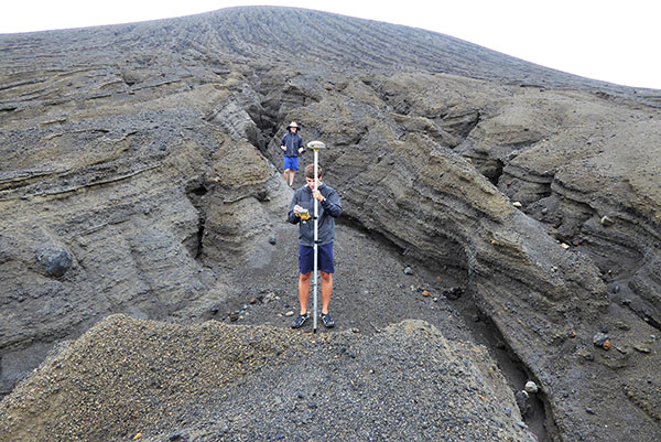
A new island near Tonga has officially been surveyed, courtesy of Goddard NASA scientist Dan Slayback.
Most new islands vanish as fast as they appear from punishing ocean waves, but this one is different. It’s one of only three volcanic islands to live longer than a few months in the past 150 years, and the first survivor since satellites began collecting Earth imagery.
“There’s no map of the new land,” Slayback said. The island, nestled between two older islands, erupted from the rim of an underwater caldera in early 2015. The older islands were on some nautical charts at coarse resolution.
Slayback has been watching the island via satellite since its birth, trying to make a 3D model of its shape and volume as it changes over time to understand how much material has been eroded and what it is made of that makes it partially resistant to erosion. But while high-resolution satellite observations provide some data, nothing beats a visit.
On Oct. 9, 2018, Slayback and students with the Sea Education Association (SEA) measured the location and elevation of boulders and other erosional features visible in the satellite image. Using a high-precision GPS unit with a rover and base station, Dan and the students took about 150 measurements that narrow down each point’s location and elevation to better than 10 centimeters. They also used a drone to conduct an aerial survey of the island for another layer of observations to make a high-resolution 3D map.
The elevation changes were more dramatic than Slayback expected. The data that the team gathered on the ground will help scientists hone the model they use to convert satellite images to ground heights, according to NASA.
NASA scientists are keen to understand how new islands form and evolve on Earth; the knowledge may provide clues about how volcanic landscapes interacted with water on ancient Mars.
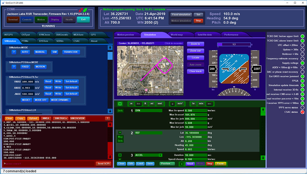
Jackson Labs Technologies has released the latest upgrades to its GPS simulator and transcoder product line.
Screenshot: Jackson Labs
The latest version of freeware application SimCon rev. 1.20 is now available. New features include:
Single-button GPS Week Number Rollover testing to test when GPS receivers will fail (hardly any will fail April 6; most older units will fail sometime between now and 2025).
Single-button GPS receiver leap second testing: Some GPS receivers might have an issue operating properly when the next leap second happens after the upcoming April 6 week number rollover, and SimCon makes that trivially easy to check.
Additional support for modern external GNSS receiver NMEA sentences for transcoding such as $GNGGA, $GLGGA, etc.
Improvements in GPS receiver switchover performance when switching from a fully GPS-denied area (running from INS) to GPS-available while transcoding in aircraft and vehicles.
This was fine-tuned based on extensive flight tests with the Navy/Air force.
Added support for the new Micro-Transcoder with its new Eval board.
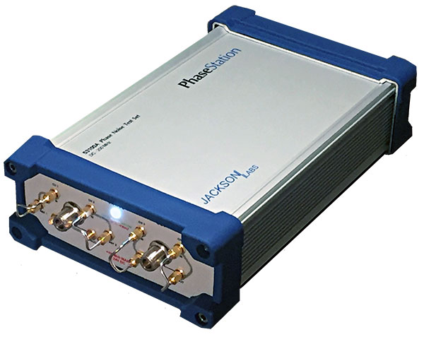
Photo: Jackson Labs
Jackson Labs also announced a new product line, the PhaseStation ADEV Frequency Stability phase noise test system (signal source analyzer).
The test system is:
useful in testing signal performance in a host of products such as GPS or GNSS disciplined oscillators.
useful to qualify and evaluate local oscillator (LO) performance for GNSS receiver design, including GPS TCXO evaluation and parametrization.
stability measurements of 1PPS and arbitrary frequency outputs from GNSS receivers
useful in optimization of GNSS receiver Kalman filter design via the GNSS receiver 1PPS output signals.
automatically synchronizes and syntonizes (calibrates) the internal dual oscillator DOCXO option to external GNSS receivers via 1PPS input.
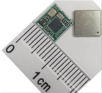
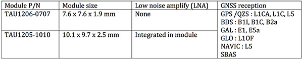
Allystar Technology Co. Ltd. has launched its smallest multi-band multi-GNSS module, the TAU-0707. Within its 7.6 x 7.6 millimeter size, the TAU-0707 series module supports major GNSS constellations (GPS / Galileo / GLONASS / BeiDou / QZSS / IRNSS) and all civil bands (L1, L2, L5, L6).
As the latest addition to Allystar’s GNSS portfolio, the TAU-0707 series module is a concurrent multi-band multi-GNSS receiver embedded with a cynosure III single-die standalone positioning chipset, which offers multi-frequency measurements to improve positioning accuracy and simplifies integration for third-party applications, said Shi Xian Yang, Allystar marketing manager.
Moreover, Allystar also provides the built-in low-noise amplifier in the TAU-1010 series module, which offers the module with improved RF sensitivity and exceptional acquisition and tracking performance even in weak signal areas.
With more and more satellites supporting L1/L5 signals, Allystar offers two modules to fully support all civil signals on the L5 band for the standalone market. The TAU1206-0707 and TAU1205-1010 are expected to be better in multipath mitigation mainly due to the higher chipping rate of L5 signals relative to L1 C/A code.
L1/L5 band module for standalone market.
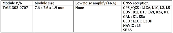
For professional applications, module TAU1303-0707 comes with built-in support for standard RTCM protocol (MSM), supporting multi-band multi-system high-precision raw data output, including pseudorange, phase range, Doppler, SNR for any kind of third-party integration and application.
Module with Raw data output for professional market.
Allystar TAU series module offers superior accuracy thanks to the onboard 26-MHz temperature compensated crystal oscillator and a reduced time to first fix relying on its dedicated 32-KHz real-time clock oscillator. Based on 40-nm manufacturing processes of the Cynosure III GNSS chipset, it comes with very low power consumption at less than 40 mA.
According to the company, engineering samples and a reference design of the Allystar TAU-0707 and TAU-1010 series module will be available in April.
Acquisition Expands Orolia’s Global Footprint into Canada.
Orolia has acquired Skydel Solutions, a GPS/GNSS signal simulation company based in Montreal, Canada.
Orolia made the announcement at the Association of the U.S. Army’s Global Force Exhibition in Huntsville, Alabama.
Orolia is a resilient positioning, navigation and timing (PNT) solutions company and a partner of U.S., NATO and allied forces. The company provides end-to-end resilient PNT solutions, including scalable, modular and cost-effective technology to support PNT-reliant and critical defense and commercial applications.
Skydel’s capabilities allows Orolia to offer customers more diverse resilient PNT solutions with sophisticated testing and simulation protocols, additional customized signals, and superior vulnerability assessments for military and commercial applications where GNSS failure is not an option.
According to Orolia, as the latest addition to the Orolia portfolio, Skydel brand solutions bring a new paradigm to the GNSS simulator scene by combining innovative algorithms and off-the-shelf hardware to help protect the world’s most critical GNSS-reliant systems operating through GPS, Galileo and other GNSS.
Skydel technology also supports secure communications signals such as SAASM, M-code, PRS and other alternative signals with approved partners to provide real-world PNT vulnerability testing for critical infrastructure applications worldwide.
“The need for continuous, reliable GNSS signals is growing exponentially worldwide, particularly for military and commercial systems that depend on accurate PNT data,” said Orolia CEO Jean-Yves Courtois. “The threats to these systems are growing too, whether it’s through signal jamming, spoofing or meaconing. With Skydel’s unique industry expertise, Orolia now offers even more rigorous, broad spectrum testing and simulation solutions to ensure continuous signals, even in GNSS-denied environments.”
By combining graphics processing unit (GPU) accelerated computing and software-defined radios (SDR), Skydel-powered simulation solutions generate signals in real time, with uncompromising performance for demanding use cases. They are available as complete turnkey systems suitable for all GNSS simulation needs, including everything from compact test benches to complete CRPA test systems.
“Since our inception in 2014, Skydel has enjoyed exponential growth,” said Stéphane Hamel, CEO of Skydel. “This strategic move with Orolia will allow us to keep our focus on disruptive innovation and accelerate our global reach.”
Above: A montage of screenshots showing the various updates, from a February 2019 story about Skydel updating its SDX GNSS simulator to version 19.1 with Galileo Alt-BOC and more. (Image: Skydel)
The U.S. Air Force’s second new GPS III satellite, bringing higher-power, more accurate and harder-to-jam signals to the GPS constellation, has arrived in Florida for launch.
On March 18, Lockheed Martin shipped the Air Force’s second GPS III space vehicle (GPS III SV02) to Cape Canaveral for an expected July launch.
Designed and built at Lockheed Martin’s GPS III Processing Facility near Denver, the satellite traveled from Buckley Air Force Base, Colorado, to the Cape on a massive Air Force C-17 aircraft. The Air Force nicknamed the GPS III SV02 “Magellan” after Portuguese explorer Ferdinand Magellan.
GPS III is the most powerful and resilient GPS satellite ever put on orbit. Developed with an entirely new design, for U.S. and allied forces, it will have three times greater accuracy and up to eight times improved anti-jamming capabilities over the previous GPS II satellite design block, which makes up today’s GPS constellation.
GPS III also will be the first GPS satellite to broadcast the new L1C civil signal. Shared by other international global navigation satellite systems, like Galileo, the L1C signal will improve future connectivity worldwide for commercial and civilian users.
The Air Force began modernizing the GPS constellation with new technology and capabilities with the December 23, 2018 launch of its first GPS III satellite. GPS III SV01 is now receiving and responding to commands from Lockheed Martin’s Launch and Checkout Center at the company’s Denver facility.
Lockheed Martin shipped the U.S. Air Force’s first GPS III to Cape Canaveral, Florida ahead of its expected July launch. (Photo: Lockheed Martin}
“After orbit raising and antenna deployments, we switched on GPS III SV01’s powerful signal-generating navigation payload and on Jan. 8 began broadcasting signals,” Johnathon Caldwell, Lockheed Martin’s Vice President for Navigation Systems. “Our on orbit testing continues, but the navigation payload’s capabilities have exceeded expectations and the satellite is operating completely healthy.”
GPS III SV02 is the second of ten new GPS III satellites under contract and in full production at Lockheed Martin. GPS III SV03-08 are now in various stages of assembly and test. The Air Force declared the second GPS III “Available for Launch” in August and, in November, called GPS III SV02 up for its 2019 launch.
In September 2018, the Air Force selected Lockheed Martin for the GPS III Follow On (GPS IIIF) program, an estimated $7.2 billion opportunity to build up to 22 additional GPS IIIF satellites with additional capabilities.
GPS IIIF builds off Lockheed Martin’s existing modular GPS III, which was designed to evolve with new technology and changing mission needs. On September 26, the Air Force awarded Lockheed Martin a $1.4 billion contract for support to start up the program and to contract the 11th and 12th GPS III satellite.
Once declared operational, GPS III SV01 and SV02 are expected to take their place in today’s 31 satellite strong GPS constellation, which provides positioning, navigation and timing services to more than four billion civil, commercial and military users.
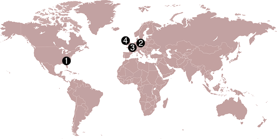
Check out some GPS developments that have recently taken place around the world. (Click to enlarge; Map: iStock.com/nadla)
1. When horses answer the call
Taking a ride in a horse-drawn carriage delights many visitors to historic Charleston, South Carolina. Until now, city crews cleaning up the presents horses leave behind have relied on flag indicators left by carriage operators. Now the city is testing a new method. Carriage operators will send the exact location to equine sanitation crews using small GPS-enabled devices. When a horse or mule takes an on-street nature break, the guide presses a button, and the equine sanitation crew is notified of exactly where to go. When the cleanup is complete, the notification is deleted.
2. Detecting rain over the ocean
Despite a wide variety of monitored geophysical parameters, GNSS signals reflected off the Earth’s surface (GNSS reflectometry) have never been used to obtain rain information. A new study presents evidence that data from the U.K.’s TechDemoSat-1 potentially enables the GNSS-R technique to detect precipitation over oceans at low winds. The study — by scientists at the GFZ German Research Center for Geosciences at Potsdam — could serve as a starting point for developing a new GNSS reflectometry application, which might also be implemented for low-cost GNSS remote-sensing missions.
Click to enlarge. (Photo: Chocolateam)
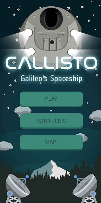
3. Gaming with Galileo
Gamers around the world can now play with the Galileo constellation. Callisto for Android uses Galileo signals in a virtual maze game based on walking through a real-world location. Looking down on Earth as if from a spaceship, players use a Google Map display to traverse an area filled with randomly generated obstacles and collectibles. The project began as an entry to European Space Agency’s Galileo App Competition 2017–2018 and was one of three apps that made it to the finals.
4. Guinness decision pending on world’s steepest street
Dunedin, New Zealand, claims to have the world’s steepest street (Baldwin), a title officially challenged in January by the town of Harlech, Wales, when residents walked up and down the narrow, winding Ffordd Pen Llech carrying a GNSS surveying receiver. A total of 14 data points were recorded on the 330-meter-long road, which had an altitude accuracy of ±5 centimeters. New Zealand surveyor Richard Hemi said the GNSS method used by the Welsh group might not be accurate. Best accuracy is to survey from the center of the road — easy on Baldwin St. but much more difficult on a winding lane. The survey was sent to Guinness World Records, which will issue a decision this spring.
Golden Software, a developer of software for data visualization and analysis, has released Version 14 of the Grapher scientific graphing package with new plotting and customizing functionality. Available today, Grapher 14 is downloadable by all users with active maintenance agreements.
A preview version of Grapher 15 is now available, giving active users pre-release access to new fit curve and statistical plotting capabilities.
“Grapher users will find we have focused overall on making the software easier to use in version 14 and the version 15 Preview,” said Leslie McWhirter, Grapher product manager. “New plotting functions were created as a direct result of feedback from users.”
The Grapher software gives users deeper insights into their data by providing them with 80 flexible and easy-to-use 2D and 3D graphing tools for plotting, analyzing and displaying scientific data sets. The package is used extensively by scientists and engineers in oil & gas operations, hydrologic/geochemical studies, environmental consulting, mineral exploration and academic research.
The most notable new or upgraded features in Grapher 14 include the following:
Enhanced Plotting – Ability to plot data in rows and columns, perform one-button Durov class plots, and easily generate multi-plot reports.
Improved Bar Charts – Bar charts are more versatile, offering variable bar widths and differentiated fill colors for negative and positive.
With Grapher 14 now available, Golden Software developers have already begun creating the Preview version of Grapher 15. This allows customers to try new functions relatively early in the development process and provide feedback before the final version is released.
“In Grapher 15 Preview, we are developing new features related to fit curve, axes and statistical functionality,” said McWhirter. “These will improve the ability of Grapher users to model, analyze and interpret their data.”
Specifically, these Grapher 15 upgrades will include:
Fit Curve Improvements – At the request of geologists, geophysicists, mining and oil-and-gas professionals, it is now possible to add X=F(Y) fit curves to model borehole log data. Fit curves can now also be added to class plots to model all or individual classes.
Axes Upgrades – Break Axes are enhanced so users can customize the break mark and add a break distinguisher to the plot itself. Ternary plots have also been upgraded to enable users to rotate the axis direction, a useful option in geochemical analysis.
Statistical Enhancements – Grapher 15 Preview will give users greater control over how values in Box-Whisker plots are graphed. In addition, there will be new mathematical options to expand on the functionality of the summation plot.
Other upgrades in Grapher 15 Preview will include the following:
Vary color fills above and below the intersection of two plots
Specify custom colors via RGB values to color scatter plot symbols
Assign colors from a gradient to scatter plot symbols based on numeric worksheet values
Grapher exports integrate seamlessly with all Golden Software packages, including Surfer for data visualization and mapping, Voxler for 3D data rendering, and Strater for subsurface modeling.
On April 6, the GPS system used by many organizations for critical infrastructure will perform a rollover. The rollover is the result of a legacy GPS navigation message which gives a week number as a 10-bit parameter.
As a result, the week number parameter in the GPS navigation message needs to reset to zero every 1024 weeks. That means from that date onwards, users are likely to start seeing rollover problems in GPS receivers that aren’t programmed to cope with the week number reset.
Meinberg, a GNSS receiver maker based in Germany, has a different approach with its GPS receivers. Instead of a 10-bit parameter, Meinberg’s firmware uses a 16-bit week number, and it is incremented at the end of each week.
This means that by the first rollover on Aug. 21, 1999, the week number sent by the satellites rolled from 1023 back to 0, while the internal (Meinberg) week number simply counted to 1024, then to 1025 and so forth. So, on April 6, the GPS week counter will reset to 0, but Meinberg’s internal one, which will have been reached the value of 2047 by that time, will continue to count in a consecutive order.
More information about the GPS Week Number Rollover can be found on our Meinberg’s Knowledge Base.
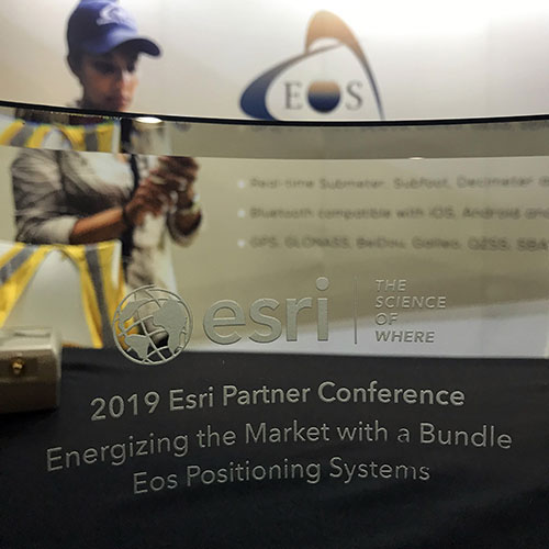
From left: Left to Right: Esri Director of Global Business Development Jeff Peters, Eos Sr. Marketing & Content Strategist Sarah Alban, Eos CTO Jean-Yves Lauture, Esri President Jack Dangermond. (Photo: Eos Positioning)
The award for “Energizing the Market with a Bundle” recognizes Eos’ seamless integration of its Arrow Series GNSS receivers with Esri mobile apps.
Eos Positioning Systems Inc., provider of submeter Bluetooth GPS and GNSS solutions, has received a 2019 Esri Partner Conference award in recognition of Eos’ contributions to Esri mobile applications.
Esri ArcGIS users benefit from bundling the Eos Arrow GNSS receivers and Esri mobile apps to create real-time, high-accuracy field GIS solutions on consumer devices such as iPads, tablets, and smartphones.
Photo: Eos Positioning
“As a long time Esri partner, this ‘Energizing the Market Award’ highlights the ongoing value Eos brings to our shared customers,” said Francis Kelly, Esri manager of Global Partner Programs. “Their thoughtful approach to connecting the field worker to the enterprise GIS creates customer satisfaction and significant ROI across our business sectors.”
“Eos has done tremendous work bringing affordable high-accuracy receivers to the Esri user community, whilst taking advantage of the latest Esri technology including Collector for ArcGIS and Survey123 for ArcGIS,” Esri Canada Director of Strategic Alliances Paul Salah said. “I couldn’t be more pleased to have them recognized for their innovation that brings such great value to field workers everywhere.”
Eos’ mission is to turn the complex world of high-accuracy submeter and RTK location into simple and affordable integrations to the Esri ArcGIS platform. This is achieved with behind-the-scenes transfers of high-level GNSS information with Esri mobile apps.
The exchange is nearly transparent to the end-user, and therefore minimizes the knowledge required for anyone to capture survey-grade 3D locations.
“It used to be really hard to collect high-accuracy data,” said Christa Campbell, Esri Global Water Practice Industry Specialist. “But now it’s very easy and affordable, so there are no limits any more. Anyone can do it.”
2018 saw small-system water utilities, municipalities, consultancies, co-ops and others adopt high-accuracy GIS at increasing rates. Eos believes this is due to a changing understanding of how easy and affordable high-accuracy data collection can be with the Eos/Esri bundle.
“We are showing that anyone can map an entire system, regardless of the size or the person’s familiarity with GNSS and GIS,” Eos CTO Jean-Yves Lauture said. “We are showing that it is simple, affordable, and profitable.”
The adoption of high-accuracy solutions among GIS users coincides with a general shift toward digitized asset management, away from paper maps and CAD drawings.
The shift is the natural result of more affordable and easier to use technologies, the proliferation of smart devices, and industry trends including increased regulations.
“Now more than ever, customers want to start taking advantage of the tremendous flexibility GIS has to offer,” Lauture said. “And the first step in creating an accurate system of record is field mapping with GPS.”
In 2018, Eos released two new innovative solutions for ArcGIS users.
The first was the result of a three-way partnership between Eos, Esri and Laser Technology, Inc.
Known as the “World’s First Laser Offset for Collector for ArcGIS,” this laser mapping solution allows field workers to collect highly accurate (submeter or centimeter) locations on their iPads and iPhones in otherwise challenging environments.
This includes GNSS-impaired environments, where view of the sky is obscured or limited, and places where occupying an asset would be unsafe or expensive (such as a manhole located in a road intersection).
“With the new collector-based laser mapping solution, organizations can save money, minimize risk and boost the efficiency of their field operations,” Esri Field Apps Product Lead Jeff Shaner said. “Without having to occupy assets in challenging environments, field workers can capture asset locations within inches of accuracy using the Eos Arrow and LTI rangefinder. This unique partnership provides advanced field data collection capabilities and drives new opportunities to extend the reach of ArcGIS.”
The second solution feeds real-time orthometric heights (Z values) directly into Collector and Survey123 for ArcGIS. By supporting real-time GEOID models, Eos eliminates the need to transform ellipsoidal heights into local vertical datum manually back at the office. This reduces time-consuming post-processing as well as makes accurate elevations instantly available for use in the field.
Eos is dedicated toward providing its customers with innovative solutions like this, which allow Esri users to stay within their existing ArcGIS mobile environments.
“This award acknowledges the work Eos has accomplished so far in bringing innovative solutions to our mutual customers with Esri,” Lauture said. “It is quite an honor for everyone at Eos, and we are especially thankful to all the Esri employees who have made the journey in getting here so enjoyable. It’s what makes us look forward to doing more in the future.”
DARPA has issued a Request for Information (RFI) to augment its understanding of state-of-the-art technologies for 3D mapping and surveying. (Photo: DARPA)
Request for Information pursues state-of-the-art technologies for collecting and characterizing 3D mapping and surveying data.
DARPA is seeking information on state-of-the-art technologies and methodologies for advanced mapping and surveying in support of the agency’s Subterranean (SubT) Challenge.
Georeferenced data — geographic coordinates tied to a map or image — could significantly improve the speed and accuracy of warfighters in time-sensitive active combat operations and disaster-related missions in the subterranean domain. Today, the majority of the underground environments are uncharted or inadequately mapped, including human-made tunnels, underground infrastructure, and natural cave networks.
Through the Request for Information, DARPA is looking for innovative technologies to collect highly accurate and reproducible ground-truth data for subterranean environments, which would potentially disrupt and positively leverage the subterranean domain without prohibitive cost and with less risk to human lives. These innovative technologies will allow for exploring and exploiting these dark and dirty environments that are too dangerous to deploy humans.
“What makes subterranean areas challenging for precision mapping and surveying — such as lack of GPS, constrained passages, dark or dust-filled air — is similar to what inhibits safe and speedy underground operations for our warfighters,” said Timothy Chung, program manager in DARPA’s Tactical Technology Office (TTO). “Building an accurate three-dimensional picture is a key enabler to rapidly and remotely exploring and searching subterranean spaces.”
DARPA is looking for commercial products, software, and services available to enable high-fidelity, 3D mapping and surveying of underground environments. Of interest are available technologies that offer high accuracy and high resolution, with the ability to provide precise and reproducible survey points without reliance on substantial infrastructure (such as access to global fixes underground).
Additionally, relevant software should also allow for generated data products to be easily manipulated, annotated, and rendered into 3D mesh objects for importing into simulation and game engine environments.
DARPA may select proposers to demonstrate their technologies or methods to determine feasibility of capabilities for potential use in the SubT Challenge in generating and sharing 3D datasets of underground environments.
Such accurately georeferenced data may aid in scoring the SubT competitors’ performance in identifying and reporting the location of artifacts placed within the course. In addition, renderings from these data may provide DARPA with additional visualization assets to showcase competition activities in real-time and post-production.
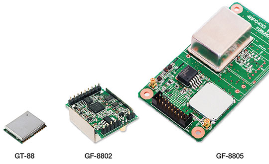
Furuno Electric Co. Ltd., based in Nishinomiya, Japan, has developed the GT-88 timing module and GF-8801/02/03/04/05 disciplined oscillator for users who require UTC time-synchronized signals to meet the new 5G requirements.
They provide UTC time-synchronized timing signals (1 PPS/10 MHz) by receiving GNSS satellite signals. Achieved stability is better than that of an atomic clock, including a rubidium.
Photo: Furuno
The GT/GF-88 series includes a brand-new algorithm, named Dynamic Satellite Selection, that provides outstanding multipath mitigation, especially in urban canyon environments, the company said. The algorithm was developed by Nippon Telegraph and Telephone Corporation (NTT) based in Tokyo, Japan.
Extremely high stability of 4.5 ns (1 sigma) is obtained, only requiring reception of the L1 band (1575.42 MHz) frequency GNSS satellites. It was achieved by improving advanced position estimation algorithms and optimizing position calculation among several different GNSS satellite constellations. It allows users to achieve 5G-required performance without any changes to existing single-band GNSS antennas.
It incorporates the Dynamic Satellite Selection, an advanced multipath mitigation algorithm developed by NTT. Normally typical time synchronization performance deteriorates in urban canyon environments by the effect of multipath. The Dynamic Satellite Selection reduces this time error by one-fifth. This provides more flexibility when installing GNSS antennas. Consequently, the GT/GF-88 series now permits GNSS antennas to be mounted on walls, windows of tall buildings and other difficult reception environments.
The GT/GF-88 series continues to support GPS, GLONASS and QZSS satellite constellations, and now adds Galileo support. As the total number of satellites available increases, operational stability also increases.