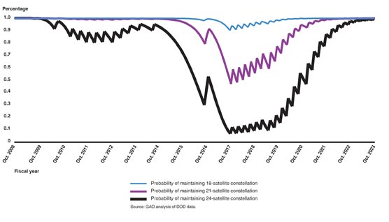
U.S. positioning, navigation and timing (PNT) capabilities are vitally important to millions of civilians, as well as U.S. and allied militaries.
The third Navigation Technology Satellite will go beyond GPS III — whose capabilities, mark you, are not yet online — to investigate new experimental antennas, flexible and secure signals, increased automation and use of commercial ground assets.
By Joe Rolli, Harris Corporation
Joe Rolli, Director of Business Development, Space and Intelligence Segment. (Photo: Harris Corporation)
Over the past decade, military leadership and national strategists have shared their concerns about U.S. dependence on GPS for everything from financial transactions to commercial transportation scheduling to precision weapon system guidance.
The new generation of Air Force GPS satellites, which began launching in late 2018, marks a significant step toward improving GPS services with three times greater accuracy and up to eight times improved anti-jamming capabilities over the previous GPS satellite block.
Now the Air Force Research Laboratory and the Space and Missile Systems Center are focusing the Department of Defense’s first experimental Navigation Technology Satellite (NTS) in more than 40 years: on initiatives that will demonstrate new tactics, techniques, and procedures to improve PNT resiliency and counter threats to GPS.
As a unique satellite that flies outside of the GPS constellation, NTS-3 will host experiments with impact across the PNT user spectrum — military, civil, academic and commercial. It will explore innovations in atomic clocks, antennas, reprogrammable digital waveform detectors, signals and other technologies.
Harris, the satellite prime contractor for NTS-3, is approaching these mission innovations from the standpoints of responsiveness and resiliency as well as technology advancement. For example, the design will support the simultaneous broadcast of dual-frequency, regional high power, and Earth coverage signals. An agile waveform platform will demonstrate the ability to rapidly develop and deploy new signal waveforms with total flexibility throughout the satellite life cycle. These innovations will allow operation in multiple contested environments, a key to achieving resiliency that can combat electronic jamming, spoofing and more.
Another strategy is the design of a modular NTS-3 payload that can be reprogrammed in space. Based on open, industry standards and interfaces, the payload will be scalable and can be hosted on diverse platforms and in varied orbits with minimal changes.
When NTS-3 launches for its planned one-year experimental campaign — anticipated to begin in 2022 — it will be the latest in a series of experimental spacecraft that have blazed the trail for the extraordinary technological advances that led to the GPS system we enjoy today
Household size distributions are critical inputs to many business analyses, but may not be correctly derived from U.S. Census data, according to Caliper.
The Census counts people at their geographic locations, and when several unrelated people live at the same address, they are reported as one household with a number of residents.
A confusing array of data is reported. In both the Census SF1 2010 file and in 2017 ACS, the following tabulations are provided down to the Census tract level:
People in Family Households
2 person Family Households
3 person Family Households
4 person Family Households
5 person Family Households
6 person Family Households
7+ person Family Households
Non-relatives in Family Households
Unmarried Partners (including same-sex couples) in Family Households
People in Non-Family Households
Unmarried Partners (including same-sex couples) in Non-Family Households
There is also extensive information on people residing in group quarters in the 2010 Census, which has the tabulations below:
People in Group Quarters: College
People in Group Quarters: Military
People in Group Quarters: Navy Ships
People in Group Quarters: Other
People in Group Quarters: Homeless
People in Group Quarters: Group Homes
People in Group Quarters: Residential Treatment
People in Group Quarters: Merchant Ships
People in Group Quarters: Workers’ Group Living Quarters
People in Group Quarters: Other Other
People in Group Quarters: Institutionalized
Using this information, Maptitude 2019 includes a corrected data set of household size distributions for Census Tracts and Block Groups to account for the under-representation of one-person households in the Census data.
Census tracts with Caliper derived households. (Image: Caliper)Census tracts with Census household count. (Image: Caliper)
SimActive Inc., a developer of photogrammetry software, announced that Correlator3D is being used for mapping projects in Brittany, France, by Altimedias.
An eBee X equipped with senseFly S.O.D.A. 3D camera is flown along the shoreline to produce high-resolution true orthomosaics and 3D models.
“The quality of outputs from Correlator3D is exceptional and the mosaic renders the vivid colours of the Pink Granite Coast,” said Didier Wasselin, COO at Altimedias, which specializes in drone data collection and processing. “Such results are very useful for heritage conservation and decision making by local authorities.”
“The combination of SimActive software and senseFly eBee Plus X is an ideal combination, due to the accurate RTK/PPK and optimized aerial triangulation,” said Francois Gervaix, technical advisor at SimActive. “The S.O.D.A. oblique imagery leads to outstanding 3D textured models.”
Administered by the National Geospatial-Intelligence Agency (NGA), the mission of IGAPP is to streamline the deployment of commercial mobile apps to government personnel by bridging the gap between traditional government contracting procedures and non-traditional businesses.
Blue Marble’s GIS software is used by hundreds of thousands of mapping professionals throughout the world who need affordable, user-friendly, yet powerful GIS solutions. Users come from a wide range of industries including software, oil and gas, mining, civil engineering, surveying and technology companies, as well as government departments and academic institutions.
Available on both iOS and Android platforms, Global Mapper Mobile enables remote access to mission-critical geospatial datasets in an easy-to-use application. Used in conjunction with the desktop version of the software, Global Mapper Mobile supports hundreds of GIS data formats — both raster and vector — and offers simple, form-based field data collection and geotagged photo capture.
To address the specific needs of the geospatial intelligence (GEOINT) community, the IGAPP version of Global Mapper Mobile includes streaming access to online data services and the ability to store downloaded tiles for remote offline use.
“IGAPP provides mission-relevant, cyber secure mobile apps to warfighters, aviators, mariners and first-responders,” according to John Holcomb, IGAPP program manager at Engility, the NGS’s broker for putting commercial applications into the GEOINT App Store. “The program provides commercial vendors with a rapid, cost effective, path to sell their products. We are thrilled to add the Global Mapper Mobile the store and look forward to getting into the hands of DoD users.”
“Over the years, the GEOINT community has strongly supported our products and has provided valuable feedback that has helped ensure the functionality of our software is addressing the needs of geo-intelligence,” stated Patrick Cunningham, Blue Marble President. “We are delighted that Global Mapper Mobile is now available through IGAPP and that more and more field personnel now have easy access to this valuable app.”
The Trimble TDC150 handheld is a new field computer designed for GIS data collection, inspection and management activities.
The TDC150 provides users with a rugged device that has the flexibility of a handheld, a modern interface with open Android operating system, and scalable high-accuracy positioning for professional field workflows.
The TDC150 provides advanced GNSS capabilities in a durable, ergonomic and lightweight form factor. With a built-in GNSS antenna, the TDC150 is a scalable solution that allows customers to choose their desired accuracy. Easy-to-use and carry in the field, it features a bright 5.3-inch sunlight-readable touch screen and an all-day battery for continuous work on the jobsite, the company said.
The handheld comes with Google Mobile Services certification to run Google core applications and access thousands of apps on the Google Play Store. Professional GIS field applications, including Trimble TerraFlex software — a cloud-based solution that enables users to easily collect, manage and edit their geospatial feature data — are supported, as well as Trimble Penmap for Android software and Esri’s Collector for ArcGIS mobile app.
A new innovative TerraFlex workflow uses the TDC150’s onboard rear-facing camera to capture features. This visual aid shows users when the camera and receiver are aligned over features, enabling horizontal centimeter accuracy when holding the device.
“The mapping and GIS industry, including utility companies, local government, and environmental management agencies, look to Trimble for continued innovation,” said Rachel Blair-Winkler, business area manager for Trimble Mapping & GIS solutions. “Adding the ability to get the level of horizontal accuracy required in a handheld configuration without the need for an external pole and antenna, and the new camera-based data logging workflow, gives our customers the flexibility to accomplish more while out in the field.”
Airbus Defence and Space and The Climate Corporation, a subsidiary of Bayer, have announced a global agreement to deliver frequently updated satellite imagery from Airbus to farmers through Climate FieldView, a digital agriculture platform.
Farmers who use Climate FieldView can access high-resolution data of their fields from the Airbus SPOT 6, SPOT 7 and Pléiades satellites throughout the growing season. This gives FieldView customers the ability to more precisely monitor crop health and performance, helping them take action in the field before yield is impacted at the end of the season.
They will also be able to visualize this satellite imagery alongside other data layers in their FieldView account, including planting and yield data, to unlock new insights about crop health.
The large swath and coverage capabilities of the SPOT satellites enable mapping at a national level down to individual farmland parcels, while the Pléiades satellites can be used to pinpoint details in specific areas, thanks to its combination of sub-meter resolution and multispectral bands.
The complementarity between SPOT and Pléiades resolutions, swaths and revisits is crucial for effectively monitoring crops more precisely and helps enable more-informed decision-making.
“We are very pleased to be working with The Climate Corporation to enhance FieldView by providing them with access to updated, cloud-free images within the time frame required to efficiently monitor crops at each key growth stage,” said François Lombard, head of Intelligence Business at Airbus Defence and Space.
“High-quality satellite imagery integrated into a farmer’s Climate FieldView account can bring in more consistent and invaluable field-level insights,” said Steven Ward, Senior Director of Geospatial and Weather Sciences at The Climate Corporation. “This partnership with Airbus supports Climate’s commitment to deliver the most robust imagery ecosystem on the farm, helping farmers make important decisions tailored precisely to their individual fields.”
The Climate Corporation’s mission is to help the world’s farmers sustainably increase their productivity through the use of digital tools. First launched in the United States in 2015, the company’s Climate FieldView platform gives farmers a deeper understanding of their fields so they can make more informed operating decisions to optimize yields, maximize efficiency and reduce risk.
FieldView is currently on more than 60 million paid acres across the United States, Canada, Brazil and Europe.
The CAST-5000 produces a single coherent wavefront of GPS RF signals to provide repeatable testing in the laboratory environment or anechoic chamber. The basic system generates four independent, coherent simulations that reference a single point and is upgradeable to support seven elements for CRPA testing. With an intercard carrier- phase error of less than 1 millimeter, the CAST-5000 is extremely accurate.
The system generates a wavefront of GPS when its GPS RF generator cards are operated in a ganged configuration. Each generator card provides a set of GPS satellites coherent with the overall configuration. Several RF generator cards may be utilized together, ensuring phase coherence among the bank of signal generator cards.
The CAST-5000 Controlled Reception Pattern Antenna (CRPA) tester allows a full end-to-end test of the antenna system. The CRPA antenna, antenna electronics and the GPS receiver can be tested as a unit with or without radiating signals.
The CAST-8000 is a new simulator that merges both the CAST-5000 CRPA tester with a CAST-3000 EGI tester.
The tiny 1-inch square Micro-Transcoder module allows glueless retrofitting of existing GPS equipment with secure and Assured-PNT (A-PNT) capability. It is the smallest, full-constellation, stand-alone, real-time 10-channel GPS simulator available from JLT. The unit is useful in upgrading existing legacy GPS receivers with external position, navigation and timing references such as INS, CSAC, SAASM, M-code, GNSS, eLoran or other alternative positioning and timing sources by simply replacing the legacy GPS antenna from an existing GPS system with the Micro-Transcoder RF output.
The unit is based on the JLT CLAW GPS Simulator and RSR Transcoder technologies, and includes a general-purpose, stand-alone, full-constellation, 10-channel, real-time GPS simulator with integrated high-stability timing reference, as well as an internal GNSS receiver for monitoring the RF output signal for quality and accuracy. The unit will transmit a standard UTC time, position, velocity and heading GPS L1 C/A RF signal by simply applying 3.3V power to it.
The Micro-Transcoder can also be operated as a generic GPS simulator with built-in GPS Disciplined Oscillator (GPSDO), and is supported by a free Windows application downloadable from the JLT website. The Windows application allows control of all the simulation aspects, creating and storing simulation vector commands and testing user equipment for leap-second and GPS week rollover event compatibility to identify weaknesses in user equipment. The unit does not require a connected PC to function. The Micro-Transcoder is also available mounted onto an evaluation board for easy evaluation. The unit transcodes baseband PNT NMEA signals into a GPS L1 RF signal with typically less than 100-ms latency. UTC 1PPS timing-transfer accuracy to the GPS RF output is typically better than 5 ns. The unit requires only 3.3V to operate, and setup, location and simulation vector file information can optionally be stored in its internal NV memory.
For those responsible for mission-critical PNT applications, the Orolia GSG series of GPS/GNSS simulators is an important tool to evaluate risk for jamming, spoofing or any other threat. Orolia GSG-5/6 series simulators are easy to use, feature-rich and affordable, offering a way to harden GPS-based systems without the limitations of testing from “live sky” signals. The Orolia platform approach allows customers to buy only what they need today and upgrade later. The adaptability of the GNSS RF generation platform can extend to applications for intelligent repeating.
Test Solutions
Position accuracy and dynamic range/sensitivity
Simulate movements/trajectories anywhere on or above Earth
Sensitivity to GPS impairments: loss of satellites, multipath, atmospheric conditions, interference, jamming and spoofing
Conducted or over-the-air RF
GPS time-transfer accuracy
Effect of leap-second transition
Multi-constellation testing
Modernization signals/frequencies
Keyless military SAASM, dual-frequency and survey-grade receiver testing
Infrastructure possibilities include zone-based indoor location (intelligent repeating) and pseudolite applications.
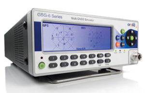
GSG-6 Series 64-channel multi-frequency, advanced GNSS simulator is powerful enough for any cutting-edge test program. GPS, GLONASS, Galileo, Beidou, QZSS and NAVIC (IRNSS) signals are available across multiple frequencies. The GSG-6 is designed for military, research and professional applications.
GSG-5 Series 16-channel multi-constellation L1-band GNSS simulator is designed for commercial development/integration programs. It is for developing commercial products with GNSS capability, and will shorten test programs with confidence.
GSG-51 single-channel signal generator is designed for one purpose — fast, simple go/no-go manufacturing test and validation, ensuring the manufacturing line is operating at full capacity with confidence in quality.
Specifically designed for testing GNSS interferences and cyber-attacks. QA707 has been designed to test robustness against emerging cyber-threats beyond jamming and spoofing. It allows the creation of scenarios with signal and code jamming, data-level cyber-attacks, denial of service threats, low-level spoofing channels control, and trajectory-controlled spoofing.
Optimal for signal modernization design. Being a flexible software defined radio (SDR) solution, QA707 is also suitable for testing of signal modernization and for the simulation of new signal components. An open API is provided to create specific signals simulation. Particularly, the tool is ready to support the upcoming Galileo Open Service Authentication (OSNMA).
Runs on a standard PC or laptop with USRP or other hardware. QA707 is compatible with several third-party hardware RF up-converters, including National Instruments’ USRP. It also can support customer’s specific hardware through the hardware API interface. Qascom introduces the new frontier of GNSS security testing. QA707 is supported from back office with custom services as well as jamming and spoofing mitigation solutions for receivers and applications. This covers 100% of customer GNSS security needs.
QA707 Main Features
Multi-constellation (GPS L1, Galileo E1, SBAS L1)
Galileo OSNMA ready
RF simulation, binary file dump, signal record and replay
Support to SDR platforms and open API for custom RF upconverters
The LabSat 3 Wideband is easy to use, cost-effective and produces extremely low noise, accurate and repeatable signals. Users can record and replay up to three different channels at 56 MHz with a bit depth of up to 3 bits I and 3 bits Q.
The following signals can be recorded and replayed:
2X CAN, RS232, and digital inputs recorded and replayed tightly synchronized with GNSS data
Small, battery or mains powered and with a removable SSD (up to 4 Tb), LabSat 3 Wideband allows detailed, real-world satellite data to be recorded then replayed on the bench. The rugged enclosure measures a compact 167 x 128 x 46 millimeters and weighs 1.2 kilograms, meaning it can be placed in a backpack and used to reliably record real-world signals in almost any situation.
SatGen Signal Simulation Software
If a user wants to simulate the signals from scratch, Racelogic’s latest SatGen signal simulation software can produce synthesized scenarios containing the full complement of popular GNSS signals: GPS L1, L2C, L5, GLONASS L1, L2, Galileo E1, E5, E6 and BeiDou B1, B2.
SatGen software allows users to quickly create accurate scenarios with their own time, place and trajectory, with any combination of constellation and signal that is currently available or will become available in the near future.
Precision-sensitive applications such as autonomous driving, control of unmanned aerial vehicles (UAV), or positioning of aircrafts during landing procedures in coordination with ground-based augmentation systems (GBAS) require that modern GNSS receivers undergo detailed tests before implementation.
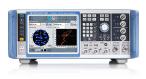
Designed to generate highly realistic test scenarios, Rohde & Schwarz signal generators like the R&S SMW200A and the R&S SMBV100B offer a unique approach to generating complex and highly realistic scenarios for testing of GNSS receivers that are able to work with diverse navigational systems such as GPS, GLONASS, Galileo, BeiDou and QZSS/SBAS signals. The R&S SMW200A and the R&S SMBV100B can emulate them all for testing.
R&S SMW200A
The R&S SMW200A GNSS simulator (pictured above) can be used to produce complex interference scenarios with multiple interferers — all generated within the instrument itself. It can emulate up to 144 GNSS channels and can be equipped with up to four RF outputs. With its ability to simulate multi-constellation, multi-frequency, multi-antenna and multi-vehicle scenarios, the R&S SMW200A is able to cover a variety of high-end GNSS applications.
R&S SMBV100B
The R&S SMBV100B supports the same navigational systems, with access to 24 GNSS channels and one RF output, with the same ability to configure realistic scenarios including obscuration, multipath and atmospheric effects, as well as the specific characteristics of the antenna and the simulated vehicle. An integrated noise and CW interference generator can also be added.
Since the devices do not require an external PC for scenario configuration, all the tests can be created quickly through the user-friendly GUI. Due to all-encompassing instrument options available, both simulators can be set up to fit unique user requirements.
For testing GNSS receivers under controlled and repeatable conditions, the R&S SMW200A and the R&S SMBV100B provide extensive and cost-effective solutions. The platforms are ready to adapt to future requirements and testing of newly implemented GNSS signals.
SDX is a proven and advanced GNSS simulator based on GPU-accelerated computing and software-defined radio (SDR).
It is available as a complete turnkey system suitable for all GNSS simulation needs, including everything from compact test benches to complete CRPA test systems, such as SDX wavefront and SDX anechoic. Moreover, its software-defined roots enable the selection of cost-effective hardware into configurations that can be repurposed for different projects.
The architecture behind SDX provides real-time simulation of uncompromising accuracy. It features advanced signal customization and supports configurable outputs. IQ data can be generated in, or imported back into, the simulator as well. The API is embedded in the simulator core, enabling deep automation with a few simple clicks, as well as complex scripts developed with popular programming languages.
SDX simulates multiple constellations on multiple frequencies (GPS, Galileo, GLONASS, BeiDou and SBAS) on a large number of channels. Encrypted codes are supported for GPS and Galileo.
The Advanced Jammer module in SDX gives users complete control over interference creation. It is integrated directly into simulation scenarios to enable dynamic jammers (up to 120dB J/S) to interact with GNSS signals.
SDX also allows users to create advanced scenarios suitable for any type of vehicle: antenna patterns (receiver and GNSS SV), LEO/GEO/HEO orbits, multipath, hardware-in-the-loop (HIL), additive pseudorange errors, message modification and corruption, raw logging and more.
It is suitable for the design and validation of GNSS receivers, complex integration, academic research, NAVWAR and test engineering.
SDX is developed and actively supported by Skydel’s engineering teams and worldwide distributors. Skydel offers direct support to clients to ensure prompt deployment and integration, or to review advanced customization requirements.
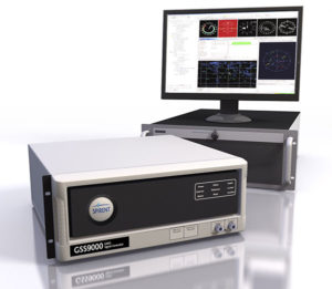
GSS9000, SIMMNSA, CRPA Test System, anechoic chamber testing, mid-range testing
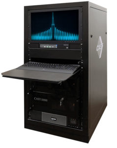
Photo: Spirent
Spirent Federal provides GPS/GNSS test equipment that covers all applications, including research and development, integration/verification, and production testing.
GSS9000. The Spirent GSS9000 Multi-Frequency, Multi-GNSS RF Constellation Simulator is Spirent’s most comprehensive simulation solution. It can simulate signals from all GNSS and regional navigation systems and has a system iteration rate (SIR) of 1000 Hz (1 ms), enabling higher dynamic simulations with more accuracy and fidelity. The GSS9000 supports restricted/classified signals. Users can evaluate the resilience of navigation systems to interference and spoofing attacks, and have the flexibility to reconfigure constellations, channels, and frequencies between test runs or test cases.
SimMNSA. SimMNSA allows authorized users to simulate true M-code for the first time ever. SimMNSA has been successfully delivered to users of the GSS9000 series simulator. SimMNSA has been granted Security Approval by the Global Positioning System Directorate.
CRPA Test System. Spirent’s Controlled Reception Pattern Antenna (CRPA) Test System generates both GNSS and interference signals. Users can control multiple antenna elements. Null-steering and space/time adaptive CRPA testing are both supported by this comprehensive approach.
Anechoic Chamber Testing. Spirent’s GSS9790 Multi-Output, Multi-GNSS RF Constellation Wave-Front Simulator System is a development of the GSS9000. The GSS9790 is a unique solution providing the core element for GNSS applications that require a test system that can be used in both conducted (lab) and radiated (chamber) conditions.
Mid-Range Solutions. Spirent also offers solutions that cater to intermediate GPS/GNSS testing needs. The GSS7000 multi-constellation simulator provides an easy-to-use solution for GNSS testing that can grow with users’ requirements. The GSS6450 RF record & playback system enables replay of a real-world GNSS/GPS test repeatedly in the lab.
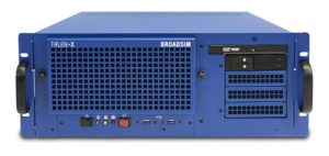
A scalable software-defined simulation platform powered by Skydel’s SDX, capable of generating high-fidelity GNSS and jamming signals simultaneously across multiple constellations and vehicles. Simultaneously simulate every signal below:
BroadSim’s software-defined platform includes intuitive user control and APIs; fast development cycles; flexible licensing and upgradability; and no additional hardware needed to maintain.
Forms
Original (4U)
Rack-mounted 4U simulator used for lab or field testing
4 RF outputs (unlimited jamming signals generated on 1)
1000-Hz simulation iteration rate
High-performance processor, GPUs and memory
Anechoic
Simulation system used for anechoic chamber testing
32 RF outputs and 16 dual-frequency antennas
Automatic antenna mapping
Automatic time delay and power loss calibration
Wavefront
Phase coherent simulation system
Real-time automated phase calibration
Scalable from 4 to 16 elements
Supports CRPA and multi-element receiver testing
Supports jamming and spoofing
Panacea
An automated PNT performance and vulnerability test suite that supports up to 32 UUTs (units under test) in real time, from test plan creation to post-test evaluation.
Time synchronization to live sky
Compatible with 100+ different GNSS receiver brands
Create dynamic scenarios with parameters such as jamming patterns, motions, power loss, delays and more.
Manages receiver communication and standardizes data output for easy analysis, visualization and reporting
The Copernicus Masters competition awards applications and solutions that use Copernicus data to tackle important challenges. Submissions for the 2019 awards opened on April 1.
The demand for Earth observation (EO) data is exploding in order to find innovative solutions for today’s challenges such as climate change, food security or water supply.
With more than 15 terabytes of free EO data generated by the Copernicus programme every day, the Copernicus services deliver near-real-time data on a global level — contributing towards the sustainable management of the environment.
Simultaneously, the Earth observation industry is constantly growing. New data platforms are being developed to receive and process the huge amount of satellite data collected from the Sentinels — and other contributing commissions.
These data platforms are established on the cloud and work with Artificial Intelligence (AI) and Machine Learning, enabling the development of new applications in the EO sector.
The Copernicus Masters 2019 — Europe’s leading innovation competition for Earth observation (EO) — is searching for such outstanding applications, solutions, and business concepts from future-oriented SMEs, startups, universities and individuals in the fields of business, research and higher education.
From April 1 to June 30, participants in the Copernicus Masters 2019 can submit their innovative EO solutions to eight challenges offered by the following world-class partners: European Space Agency (ESA), the German Aerospace Center (DLR), Astrosat, Planet, BayWa and Airbus together with sobloo and the German Federal Ministry of Transport and Digital Infrastructure (BMVI).
“The Copernicus Masters is the innovative driver for future-oriented applications and business concepts using Earth observation data. This creates socio-economic benefits through public services all over Europe. Besides, it supports business ventures and high-tech jobs in Europe’s digital economy,” states Josef Aschbacher, director of ESA’s Earth Observation Programmes. ESA is an initiating partner of the Copernicus Masters and has set a challenge for participants every year since 2011.
Participants can demonstrate their innovative use of Earth observation data across a wide variety of challenge topics, including the fields of future EO, Artificial Intelligence (AI), machine learning, energy, health, sustainable living, smart farming, and digital transportation, as well as maritime, defence & security.
“Since 2011, the Copernicus Masters competition has evolved into the leading innovation platform for promoting user uptake of Earth observation data in a commercial, societal and sustainable context. Each year, it showcases new solutions and trends, serving as an integral part of an international EO innovation network,” adds Thorsten Rudolph, managing director of AZO, the competition organizer.
Together with cash prizes, challenge winners will receive access to an international network of leading Earth observation organizations, substantial satellite data quotas, and business development support worth more than EUR 450,000 in total. The Overall Winner will receive an additional cash prize of EUR 10,000.
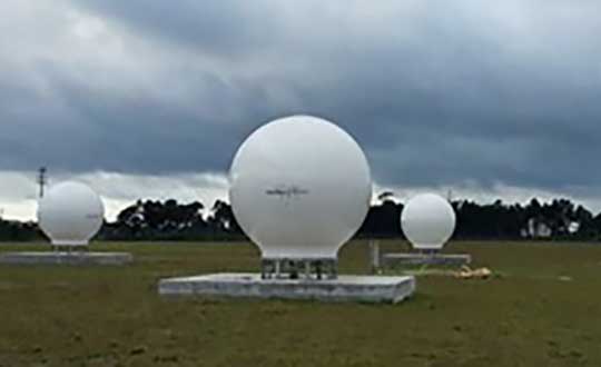
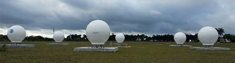
Orolia has successfully installed the first operational Cospas-Sarsat second-generation technology on search-and-rescue ground stations for the National Oceanographic and Atmospheric Administration (NOAA) in Florida and Hawaii.
The ground stations have been upgraded with second-generation beacon (SGB) signal-processing capabilities to more accurately and quickly locate the source of distress signals.
The NOAA Florida and Hawaii ground stations are the only operationally ready Medium Earth Orbit Search and Rescue (MEOSAR) ground stations in the world to receive the SGB signal specification capability.
The Cospas-Sarsat global search-and-rescue system developed specifications for the second-generation 406-MHz search-and-rescue beacon, which uses a modern, spread-spectrum signal to achieve more accurate and robust performance.
“The work performed by Orolia was exceptional, as the process of upgrading an operational system to a higher set of requirements, years after its initial design, involves minimizing downtime while validating the new requirements and revalidating the previous requirements,” said Mickey Fitzmaurice, NOAA SARSAT Systems Engineer. “The successful result makes it obvious that the engineering and operations team at Orolia put a great deal of time and effort into planning the upgrade, as the execution was seamless.”
“This series of world firsts demonstrates Orolia’s broad technical leadership in the global search and rescue ecosystem,” said Orolia Director of SARSAT Operations, Steve Ludwig. “We continually innovate to enhance the usefulness of these technologies, from generating encrypted beacon alert signals to including alert authentication through the use of Galileo Return Link Service.”
Cospas-Sarsat ground stations are called Local User Terminals (LUTs). These satellite receiving units are the ground stations that receive emergency beacon distress alerts. (Photo: NOAA)
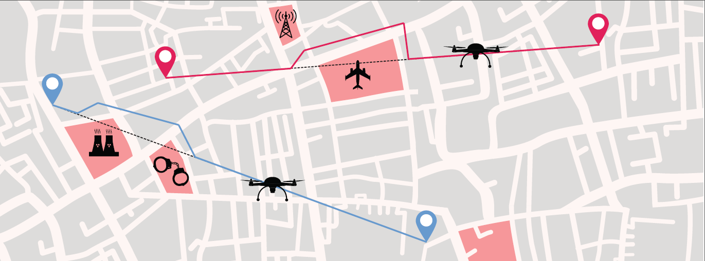
Thales is leading the SESAR Joint Undertaking to research and develop new services for safe, efficient and secure access to airspace for drones.
The SESAR Joint Undertaking (SESAR JU) supports the European Commission’s U-space initiative by researching and developing new services for safe, efficient and secure access to airspace for an expected increase in drone use.
The Geosafe project is part of the founding services for the development of drones operation. Thales will manage the project, supported by Aeromapper, AirMap, Atechsys, Airmarine and SPH Engineering.
The 280 flight tests with 16 different drones will be conducted in France, Germany and Latvia. These tests will explore all possible situations that an automated drone will face in urban and rural areas.
By securing the flight pattern of drones to avoid determined zones, geofencing solutions are key safety enablers. Geofencing ensures that drones don’t fly in protected perimeters around critical infrastructures, such as power plants or airports.
The objectives of Geosafe are to establish state-of-the-art geofencing solutions regarding U-space regulation and to propose improvements and recommendations for future geofencing system definition.
Geosafe will be based on a one-year-long flight-test campaign, assessing a number of commercially available geofencing solutions so that it can propose an improved geofencing system and technological improvements for automated drones.
Thales designs systems ensuring high security and safety levels for future air mobility. As the leader of the project, Thales will organize all tests and provide recommendations for the European geofencing system.
“Thales is playing a leading role in shaping the autonomous world,” said Christian Bardot, Thales VP in charge of Helicopter and UAV Avionics Business. “Together with SESAR JU and the Geosafe partners, we will strengthen the foundations of drones’ safe and secure operations, unleashing the potential of this tremendous market.”
Autotalks, a V2X (vehicle-to-everything) communication company, is gaining momentum in the Chinese market following the successful completion of the C-V2X field test with a Chinese technology giant.
The field trial evidenced Autotalks’ C-V2X capabilities on a public road, including 3GPP release 15 compliant transmit diversity, and remarkable communication range of over 2 kilometers with a nominal range of over 1.5 kilometers.
As part of its momentum in China, Autotalks is growing its Chinese partner ecosystem and hiring for its operation in this giant market. Autotalks is a member of IMT-2020, CAICV and China ITS Industry Alliance, working on standardization and testing of C-V2X towards mass deployment. The company has also launched a Chinese website.
China is a fast-growing region in the automotive and intelligent transportation systems (ITS) segments. LTE-V2X technology has been gaining strong momentum in China. In November 2018, Autotalks announced that it has recruited Xiaobing Yang, to lead Autotalks’ business development efforts in China out of Autotalks’ new branch in Beijing. Yang brings to Autotalks more than 25 years of experience in the Chinese telecom industry.
In 2018, Autotalks launched a global V2X solution supporting both DSRC and LTE-V2X (also known as C-V2X) based on its second-generation mature chipset with the intention of expanding its global footprint into China. Autotalks’ LTE-V2X direct communications (PC5) solution is separated from the cellular Network Access Device (NAD), resulting in a secure and cost-effective standalone LTE-V2X solution.
Autotalks announced in February that it has partnered with MediaTek. a global fabless semiconductor company that enables 1.5 billion connected devices a year. The two companies are cooperating on integrating V2X and telematics and have completed a joint reference design for Telematics Control Unit (TCU) integrated with a global V2X chipset.
The reference design is based on Autotalks’ global V2X chipset and MediaTek’s newest technology, an automotive-grade cellular modem SoC, enabling a secure, robust and cost-effective global TCU architecture.
The WingtraOne vertical take-off and landing (VTOL) fixed-wing mapping drone now carries the RedEdge-MX multispectral sensor for vegetation mapping.
The WingtraOne is a VTOL drone that allows for flexible take-off and landing, with automated vertical take-off and landing even on gravel or in forest isles.
The WingtraOne provides wide coverage for comprehensive and high-quality multispectral image gathering, with coverage of up to 160 ha (395 ac) with 8.2 cm (3.2 in)/px GSD at 120 m/ 394 ft in one flight.
The Terrain Following feature provides for intuitive flight planning with fully automated functionality, the company said.
The RedEdge-MX features a patent-pending DLS 2 and a calibrated reflectance panel that enhances radiometric calibration and provides useful data for comparison of results over time, improving crop and stand monitoring.
The camera captures five narrow spectral bands: red, green, blue, near infrared and red edge. It generates plant health indexes and RGB (color) images from one flight, and is calibrated for precise, repeatable measurements.
Standard data outputs are compatible with almost all processing platforms.