Denver International Airport (DIA) has fully implemented its new arrival and departure procedures, the next phase in the Federal Aviation Administration’s mass overhaul of U.S. airspace, called NextGen. Denver is among the airports at the front end of the adoption process, and is highlighted in an in-depth feature in the Denver Post.
According to the article, “The recently completed phase at DIA trims arrival and departure fuel costs by eliminating several intermediary steps. The traditional system requires an airplane to come into and out of cruising altitude by firing its thrusters at every new altitude level, wasting hundreds of pounds of fuel… The traveling public will not likely notice an immediate difference in travel time, but proponents hope that the early investment pays off in the end.”
The FAA predicts that NextGen improvements will reduce flight delays by 38 percent and lead to a 1.4-billion-gallon total reduction of fuel burn by 2020.
ST-Ericsson, a joint venture of STMicroelectronics and Ericsson, has sold its mobile connectivity GNSS business to Intel.
ST-Ericsson, which focuses on mobile and wireless chips, announced the sale on Tuesday without naming the buyer. An Intel spokesman later said the U.S. chipmaker bought the assets.
According to ST-Ericsson, the sale “represents another step in the execution of Ericsson’s and ST’s announcement of March 18, 2013,” when the company announced it was winding down the joint venture. Ericsson will assume 1,800 employees and contractors, with the largest concentrations in Sweden, Germany, India and China. ST will assume 950 employees, primarily in France and in Italy.
In addition to the assets and intellectual property rights associated with this business, 130 employees in Daventry, UK, Bangalore, India, and Singapore are anticipated to join Intel at closing of the transaction, and will be added to Intel’s already-existing GPS assets.
The closing of the transaction is subject to regulatory approvals and standard conditions and is expected to be completed in August. ST-Ericsson estimates the proceeds from the sale, combined with the avoidance of employee restructuring charges and other related restructuring costs, will reduce the joint venture’s cash needs by approximately $90 million.
“Today’s transaction validates the leading innovation developed by ST-Ericsson in mobile navigation systems and marks a further important step towards the execution of our shareholders’ decision to exit from ST-Ericsson” commented Carlo Ferro, President and CEO of ST-Ericsson. “I am pleased that this organization will continue to develop leading-edge technologies and delighted that the team found a new home at a leading player in the semiconductor industry.”
Swiss u-blox introduces the surface-mount MAX-M5Q, a compact satellite positioning module that supports GPS and GLONASS, as well as Japanese QZSS satellite GNSS systems. High-performance GPS/GLONASS parallel operation is also supported to enhance positioning speed and accuracy.
Designed for use in rugged environments and wide temperature range, MAX-M5Q is intended for industrial machine-to-machine (M2M) applications as well as Russia’s ERA-GLONASS emergency call system. MAX-M5Q enhances positioning in poor GNSS satellite visibility conditions as well as in high latitude and polar regions, u-blox said.
“With parallel GPS/GLONASS operation, MAX-M5Q is able to track all 50 and more U.S. and Russian satellites to deliver incomparable speed, accuracy, and positional availability,” said Thomas Nigg, vice president of Product Marketing at u-blox, “Its compact size and high-reliability makes it an ideal positioning solution for mobile resource management and ERA-GLONASS emergency call applications.”
With dimensions of 9.7 x 10.1 x 2.5 mm, MAX-M5Q is the newest member of u-blox’ MAX GNSS LCC module series. Additional features include autonomous A-GPS that reduces warm start TTFF by as much as 90%, and an embedded data logger which can store location information to internal Flash memory for up to 16 hours at 15 second intervals.
Hemisphere GNSS has rolled out the R330 GNSS receiver, a versatile, fully featured positioning system. R330 delivers accurate and robust positioning through a variety of differential correction methods including SBAS, L-Band, Beacon and RTK, the company said. With its wide range of functionality and ease of use, the R330 is suitable for a variety of land and marine applications.
The R330 GNSS receiver combines the functionality and front panel display of all previous R-series products. Customers can start with sub-meter positioning accuracy and upgrade the receiver with subscriptions that add functionality and improves performance capability to centimeter-level accuracy. To provide the most reliable solutions, R330 is capable of tracking multiple frequencies and multiple constellations including GPS and GLONASS. Users can easily switch between the various DGPS correction options without any downtime. The R330 GNSS receiver is compatible with many of the Hemisphere GNSS’ multi-frequency antennas.
The small, rugged receiver includes a display and status indicators for a user-friendly experience, Hemisphere GNSS said. A standard USB flash drive can be used for data logging.
“The functionality and performance of the R330 receiver can be custom-fit to positioning applications such as pipeline, marine, and volumetric surveys, GIS mapping, vehicle tracking, machine control, meter monitoring and many others,” said Ron Ramsaran, senior product marketing manager at Hemisphere GNSS. “R330 customers will benefit from the reliability, value, and upgrade options that can be added to meet changing needs.”
R330 features Hemisphere GNSS’ exclusive Eclipse SureTrack technology, enabling a more robust RTK solution with fewer dropouts in congested environments and a fast reacquisition when dropouts do occur. Long-range RTK baselines of up to 50 km are achievable with R330.
The R330 GNSS receiver will be available in June through the Hemisphere GNSS Precision Products global dealer network.
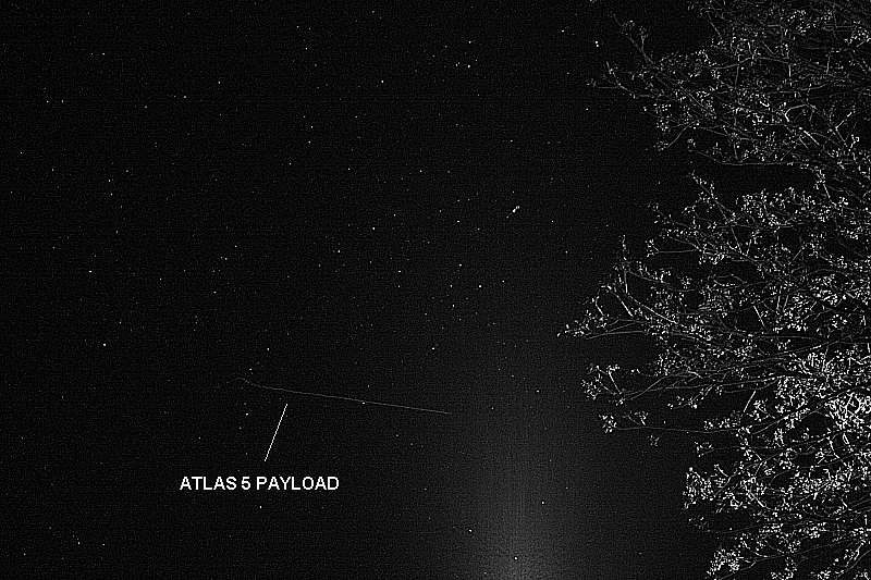
UPDATE, May 24, by Richard Langley: The Centaur upper stage with the payload still attached was photographed from Tavistock, Devon, in the U.K. by Andy Smith. As can be seen from the ground trace figure in an earlier GPS World news item, the Centaur passed over the U.K. following MECO1, the first main engine cutoff. From Europe, the Centaur could be easily seen by reflected sunlight against the background stars. Its maximum (apparent) brightness magnitude has been estimated as -1 or -2. (Sirius, the brightest star in the night sky, has a magnitude of -1.5; Betelgeuse in the constellation Orion has a mean magnitude of about 0.4; and the limiting visual magnitude for the unaided eye is about 6.)
Smith’s photograph was taken at 21:58:38 UTC (start) with a Canon EOS 450D Digital Rebel camera with an 18-55mm zoom lens. The camera settings were: focal length 55mm, aperture f/5.6, and an exposure of 8 seconds at an ISO value of 1600. Two images are shown below: the original, as obtained from the camera, and a greyscale image with edge enhancement.
The Centaur can be seen traveling left to right and starts its track as it crosses the constellation of Cygnus. There’s a slight wobble at the beginning as the shutter release was pressed. The glow at the bottom of the frame is from a streetlight. The elevation angle of the Centaur was approximately 12 degrees.
SVN66 will operate as PRN27 and it will eventually occupy the C-2 orbital slot, replacing SVN33/PRN03, a Block IIA satellite launched in 1996. SVN66 is currently in a drift orbit about 400 kilometers above the operational constellation. It should reach the C-2 slot within a few days from now. The satellite has already been added to the broadcast almanac although it has not yet started to transmit standard signals. It is currently marked as unhealthy in the almanac and will remain so, even after standard signals are switched on, until testing is completed sometime this summer.
Centaur upper stage with the payload still attached, original photo. Photo credit: Andy Smith
The same photo digitally enhanced:
Digitally enhanced photo. Photo credit: Andy SmithPhoto credit: Pat Corkery, United Launch Alliance.
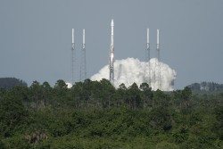
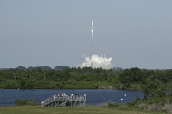
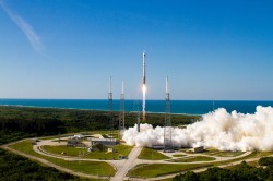
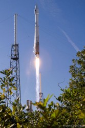
A U.S. Air Force Global Positioning System satellite built by Boeing was successfully launched May 15. The fourth GPS IIF satellite, Space Vehicle Number (SVN) 66, was carried aboard a United Launch Alliance Atlas V Launch Vehicle at 5:38 p.m. EDT (21:38 UTC) May 15 from Cape Canaveral Air Force Station, Florida.
The new capabilities of the IIF satellites will provide greater navigational accuracy through improvements in atomic clock technology; a more robust signal for commercial aviation and safety-of-life applications, known as the new third civil signal (L5); and a 12-year design life providing long-term service. These upgrades improved anti-jam capabilities for the warfighter and improved security for military and civil users around the world, the Air Force said in a statement.
“I’m extremely pleased with today’s launch and delighted to be part of this mission that enhances our nation’s critical GPS capability. Thanks to the superb efforts of the of the 45th and 50th Space Wings, United Launch Alliance, our industry partners, the Atlas V and GPS IIF launch teams, the GPS IIF-4 mission was successfully carried out,” said Col. Bernie Gruber, director of the Space and Missile Systems Center’s Global Positioning Systems Directorate.
“The GPS constellation remains healthy and continues to meet and exceed the performance standards to which the satellites were built. Our goal is to deliver sustained, reliable GPS capabilities to America’s warfighters, our allies and civil users around the world, and this is done by maintaining GPS performance, fielding new capabilities and developing more robust modernized capabilities for the future,” said Colonel Gruber.
Here are videos of the launch:
Opening photo by Pat Corkery, United Launch Alliance.
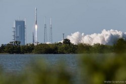
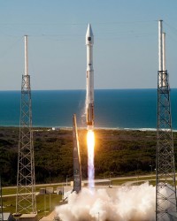
Photos show the launch of the U.S. Air Force’s GPS IIF-4 satellite from the Kennedy Space Center and Cape Canaveral Air Force Station.
Photo credit: Stephen Clark/Spaceflight Now
Photo credit: Stephen Clark/Spaceflight Now
Photo credit: Pat Corkery, United Launch Alliance.
Photo credit: Walter Scriptunas II/Spaceflight Now
Photo credit: Walter Scriptunas II/Spaceflight Now
Photo credit: Walter Scriptunas II/Spaceflight Now
Photo credit: Pat Corkery, United Launch Alliance.
Photo credit: Walter Scriptunas II/Spaceflight Now
The chief designer of the BeiDou Navigation Satellite System said China will advocate the use of the system, which will be compatible with new devices, “so that Beidou can function properly and independently even if something goes wrong with the GPS.”
Sun Jiadong, chief designer of BDS and an academician of the Chinese Academy of Sciences, made his comments in an interview with The Beijing News, as reported by the Chinese government’s website.
He added that this compatibility is the only way to ensure the protection of national information. “Safety issues abound in economic areas,” said Sun. “Ordinary people may have few concerns about the security of information but it is of vital significance.”
The development of Beidou also largely depends on the government’s involvement. “Even though the enterprises spare no effort in developing the system, the products they make would not be available for mass production, which will in turn be reflected by the prices. The government has to promote the research and development of the system,” Sun said. Sun cited the governments of Beijing, Shanghai, and Guangzhou as examples of local governments that were effectively helping to develop the BDS.
The use of Beidou could go beyond basic navigation functions and extend to the civilian market. It would take longer for the BDS to be available for civilians, said Sun. The use of Beidou on mobile phones relies on the development of a small and power-efficient chip. Otherwise the phone cannot be used.
When asked about when and how the cost of developing the BDS will be recovered, Sun reiterated that Beidou was developed to ensure the security of national information, and not to make profits.
The Beidou global navigation system will be available by 2020 with the launching of more than 30 satellites.
The fourth International Colloquium on Scientific and Fundamental Aspects of the Galileo Programme will be held in Prague, Czech Republic, December 4–6.
Since 2007, the worldwide scientific community has met every two years to discuss the possibilities for boosting the scientific use of Galileo and for contributing to the development of the GNSS.
The event is always organized in one of the 20 European Space Agency’s Member States, and makes an essential contribution to ESA’s implementation and definition of the evolution of the European GNSS. The gathering of major academic players provides a scientific reference for institutional executives and industry, as well as offering a unique platform for promoting innovative GNSS initiatives at large.
The colloquium focuses on four major areas of research:
Scientific applications in meteorology, geodesy, geophysics, space physics, oceanography, land surface and ecosystem studies, using either direct or reflected signals, differential measurements, phase measurements, radio occultation measurements, using receivers placed on the ground, in aircraft or on satellites.
Scientific developments in physics, dealing with future GNSS, particularly in testing fundamental laws in astronomy and in quantum communication. Relativistic reference frames and relativistic positioning will be addressed.
Aspects of metrology such as reference frames, onboard and ground clocks, and precise orbit determination.
Scientific aspects of satellite navigation and positioning such as signal propagation, tropospheric and ionospheric corrections and the means to model and mitigate multipath and interference.
The various possibilities to use navigation satellites such as Galileo for scientific purposes will be reviewed and the use of scientific applications to contribute to make the most of the present systems and define their evolution will be scrutinized.
The conference is being organized as a series of plenary talks and two parallel half-day sessions.
Online submission of abstracts is open until June 14 through the colloquium website, where other detailed information is also available.
skobbler brings together hybrid online and offline worldwide maps and full turn-by-turn navigation in a low-priced app with the launch of GPS Navigation & Maps for Android.
skobbler is looking to exploit the weaknesses of established Android navigation alternatives with the fully featured GPS Navigation & Maps, which offers an improved experience compared to both Google Maps and high-priced third-party alternatives, skobbler said. GPS Navigation & Maps is effectively two apps in one, with both online and offline turn-by-turn navigation and digital mapping for smartphones.
Using open-source digital map OpenStreetMap and powered by the skobbler NGx map engine, GPS Navigation and Maps has full online and offline capability. The £1 price includes worldwide online functionality as well as an installable map of one country of choice for offline use. From here, users have the option to in-app purchase individual cities, states, countries and continents to use offline, and worldwide maps are available as standard for online use. Existing users of ForeverMap 2 will receive a free upgrade to GPS Navigation & Maps. New users can either purchase the full app or try GPS Navigation & Maps’ free app with unlimited online functionality and a 14-day navigation trial.
While Google Maps is free to download and use, its offline functionality is restricted. Users cannot perform any searching or routing tasks without an Internet connection, which means that when abroad or in low signal areas they either have to pay expensive roaming costs or spend a significant time without map coverage, limiting its usability while traveling, skobbler said. Expensive alternatives such as Co-Pilot Live or TomTom UK & Ireland/Europe do offer premium features and offline navigation, yet none of them give users a choice of which areas they want to use online and which offline. Most premium sat nav apps generally cannot be used as travel apps at all, as their pure map functionalities are limited at best. GPS Navigation & Maps is the perfect blend. Offering the best of both worlds for a fraction of the price, it can be relied upon to deliver any place, at any time, and being two great apps in one offers a fantastic cost-to-benefit ratio and unbeatable flexibility for consumers, skobbler said. Individuals can build their own navigation and maps app depending on what resources they use the most, and more effectively manage the limited storage space on their devices, skobbler said.
GPS Navigation and Maps has full turn-by-turn navigation, worldwide mapping and all features of the software accessible both online or offline. This unique move, and market first, is made possible thanks to skobbler’s NGx map engine, which delivers a seamless browsing experience with ultrafast real-time rendering and stunning map visuals, skobbler said. NGx also offers a range of unique map styles to, for example, accentuate color density for outdoor use to improve clarity. Maps are highly customizable with control over features such as online/offline functionality, map display (style and zoom), routing, map matching and more.
“We’re very proud to launch the first navigation product utilising our powerful NGx mapping engine,” said skobbler CTO Philipp Kandal. “Being the first and only company on the Android platform to offer full online and offline capability for both mapping and navigation, we hope both new users and our existing customers will be won over by the high performance and flexibility GPS Navigation & Maps offers. We’re already working on future updates and have a few powerful additions lined up to improve the app’s functionality and flexibility even further in the coming months.”
Additional maps beyond the free map provided will be available via in-app purchases for offline use. In keeping with the low price for the initial app purchase, add-ons are similary competitive and are priced at £0.77 for cities, £1.11 for states, £2.22 for a whole country, £4.44 for a continent and just £7.77 for the entire planet, so users can quickly and easily supplement their map coverage as they see fit.
skobbler is committed to providing regular updates to users to keep maps fresh and accurate, and promises a range of new premium features in future updates. GPS Navigation & Maps is now available from the Google Play Store, with existing ForeverMap 2 users able to upgrade for free.
The full version of GPS Navigation & Maps, including one free offline country map, can be downloaded.
Accord Technology’s NexNav GPS receiver will be supporting FreeFlight Systems with its recently awarded FAA Capstone Retrofit Project. In March 2013, FreeFlight and Accord announced their collaboration to develop practical and cost-effective ARINC 429 WAAS GPS solutions that enable aircraft operators to meet ADS-B, RNP (0.3) and other performance-based navigation mandates, worldwide.
The NexNav Circuit Card Assembly (CCA) will integrate with FreeFlight’s upgraded automatic dependent surveillance-broadcast (ADS-B) avionics to fulfill the requirements of the second phase of the FAA Capstone Project.
“This is an excellent example of how we are working closely with FreeFlight Systems to create state-of-the-art NextGen solutions that are not only meeting upcoming mandate requirements but doing it in a cost effective manner,” stated Hal Adams, Chief Operating Officer for Accord Technology, LLC.
The Accord Technology NexNav product line revolves around two key receivers, NexNav mini and NexNav MAX. The receivers are at the heart of embedded customer solutions whether as a Circuit Card Assembly (CCA) or embedded in the Line Replacement Unit (LRU) as a stand-alone GPS solution.
NexNav mini was the industry’s first GPS receiver and sensor qualified to fully support the known worldwide and U.S. FAA ADS-B GPS source requirements The NexNav mini and MAX are compatible with EGNOS and other Satellite Based Augmentation Systems (SBAS) to the extent they are is compatible with WAAS.
Rohde & Schwarz and 7Layers have verified and validated the synchronized test approach to determine the Envelope Correlation Coefficient (ECC), a value characterizing the antenna subsystem of multiple-input and multiple-output (MIMO) LTE devices. The Synchronized ECC approach delivers significantly shorter test durations and repeatable results, ultimately resulting in reduced costs. Long term, this collaboration will also help product manufacturers develop devices that achieve greater data speeds over LTE by using highly optimized MIMO antenna configurations, the companies said.
The Synchronized ECC approach involves over-the-air transfer of measured data between the test platform and a mobile device in a synchronized fashion. This method, proposed by a leading U.S. wireless carrier, does not require any overhead or user interaction to calculate the ECC, making it easier and faster to execute test versus other approaches. 7Layers test engineers used the Rohde & Schwarz TS8991 OTA Performance Test System and software option R&S AMS32-K30 as a test platform for validation.
”7Layers is excited to help bring an ecosystem of vendors together to advance testing of LTE enabled devices utilizing MIMO,” commented Mahesh Kodukula, business development manager of 7Layers. ”As an accredited test laboratory, we provided a realistic test environment for our partners.”
”We are pleased to enable this type of testing on our R&S TS8991 OTA test platform and to offer this functionality to a variety of customers that have been waiting for this feature,” said Thorsten Hertel, OTA product specialist at Rohde & Schwarz. ”We strive to meet the industry needs of the leading edge development of LTE devices.”
Visit Rohde & Schwarz at CTIA 2013, May 21 23 at booth 4148 in the Sands Expo and Convention Center, Las Vegas, NV.
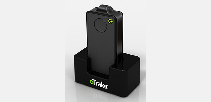
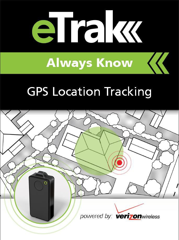
eTrak has released its GPS+ line of consumer and commercial tracking products. GPS+ is eTrak’s patent-pending technology that integrates Wi-Fi, cellular triangulation and GPS to achieve the most accurate positioning possible, both indoors and out, eTrak said.
GPS+ delivers accurate location in real time directly to a smartphone, tablet or computer. eTrak products also contain geofencing capability, which triggers notifications if the device goes beyond preset boundaries. Additionally, the notifications provide a map and address with the location of the device.
“Small and large businesses will benefit from tracking their assets with loss prevention and cost savings,” said eTrak CEO, John Harris. “They will also be able to keep their employees safe and know if they are in danger or need assistance.”
Set-up and the use of eTrak products is simple, the company said. Users can go to eTrak.com and start tracking from any smartphone, tablet or computer and instantly see the location of the eTrak device. The eTrak consumer device is also equipped with an emergency panic button that sends help requests to predetermined recipients in the event of an emergency.
“eTrak is the size of a domino and weighs less than an ounce,” Harris said. “eTrak provides the longest battery life available, and is a low cost personal emergency-response product. And with Verizon’s industry-leading coverage map, it works almost anywhere.”
The eTrak product line encompasses commercial applications, as well as consumer segments including health-impaired, special needs, teens and pets. eTrak also supplies custom design and development services.
GreenRoad, a driver performance management company, has announced new features including RFID-based driver identification; real-time email alerts; and an enhanced interface for GreenRoad Smartphone Edition.
GreenRoad’s new RFID feature automates driver association with trips by detecting when a driver boards a vehicle, eliminating the need for drivers to log on with a Dallas key.
One customer, Big Bus Tours, operator of open-top sightseeing tours, has starting using RFID in its fleet of open top tour buses in London, Washington, D.C., and San Francisco, with Dubai and Abu Dhabi soon to follow. Gerry Price, group commercial director, said, “GreenRoad has enhanced driver performance and cut risk in our bus fleet across the world, as well as improving the customer experience for thousands of sightseers. Now with RFID it is even easier for our drivers to use GreenRoad.”
GreenRoad Smartphone Edition has been enhanced with Facebook integration that allows drivers to share their achievements with friends. GreenRoad Smartphone Edition, code named “Asimov,” uses smartphone native functionality, including GPS and built-in accelerometers, to eliminate the need for a professionally installed telematics device in the vehicle.
A new version of GreenRoad Central, the software at the heart of the GreenRoad service, includes real-time alerts for exception events, including high-risk events in all driver behavior categories as well as speed violations. In addition to receiving email alerts in real-time, managers can view their alerts on a To Do list through GreenRoad Central.