Author: GPS World Staff

  • ComNav Offers GPS+BeiDou Board

    The K501 GNSS OEM board by ComNav is a GPS+BeiDou small-sized OEM board. K501 has advanced dynamic acquisition ability and high-accuracy carrier phase calculating. By using the GPS+BeiDou dual system high-dynamic processing engine, work in difficult environments is easier and RTK positioning accuracy can reach the centimeter level. The hardware size, interface, and data command are compatible with major brand OEM boards.

    201342815202868161
    The K501 GNSS OEM board by ComNav

    Features include:

    • GPS L1/L2+BeiDou B1/B2 dual satellite system calculating
    • Configurable GPS/BeiDou single-system positioning and GPS+BeiDou dual-system positioning
    • Compatible with other major brands on physical size, interface and data command
    • Directly export PJK coordinate
    • Supports short, middle and long baseline, RTK working distance can reach 50 KM
    • Easy to customize, can satisfy different kinds of demands
    • Built-in 100M internal memory
  • ComNav BeiDou+GPS Receiver Provides Positioning in Antarctic

    China’s icebreaker Xuelong, or Snow Dragon, returned to Shanghai April 9 after successfully completing China’s 29th Antarctica scientific expedition. As a high-accuracy GNSS solutions provider, ComNav supplied a GPS+BeiDou GNSS receiver for this expedition. This was the first time that the ComNav GNSS receiver worked in such an extreme environment.

    The reliable performance of the receiver impressed the expedition team. “The fast-searching satellites speed and the accurate positioning result saved us lots of time in the extreme cold field,” said one team member. It was the first time that a BeiDou receiver was used in the Antarctic, according to ComNav.

    The research vessel left the southern port city of Guangzhou on November 5, 2012, for Antarctica. It covered 29,000 nautical miles over its 156-day southern voyage, among which 6,000 nautical miles were in ice regions. A total of 239 researchers on board completed 53 research tasks on biology, ecology, geophysics, ocean, climate, environment and glacier, and engineering construction missions.

  • Game Golf Offer Golf Game Tracking Technology

    Game Golf, a wearable technology and integrated software platform for golf, is available for pre-0rder, and expected to be released this summer. Backed by professional golfers Graeme McDowell and Lee Westwood, it seamlessly records a player’s golf game to make the game more engaging, visual, interactive, shareable and social, both on and off the course.

    “Game Golf not only gives everyone access to crucial data to dramatically improve your golf game and handicap, but it also makes playing more motivating, rewarding, social and fun,” said Graeme McDowell, 2010 U.S. Open Champion and Game Golf investor. “The product is extremely intuitive, doesn’t disrupt your game and is essential for any golfer looking to understand their game better, knock down their handicap, give themselves a competitive edge and compete with their friends and family across the globe.”

    Game Golf is designed by fuseproject and Yves Béhar, CEO of fuseproject and Chief Creative Officer at Jawbone, the maker of the wireless Jambox speaker. The Game Golf elegant and discreet wearable device tracks the data around the course, and uploads the data automatically to an intuitive app which allows you to track, analyze and share the data collected.  It tracks the most important statistics from your golf game, including club-by-club performance, fairway accuracy, greens in regulation and putting.

    “The design of the Game Golf app and product has been closely integrated: a beautiful and dynamic presentation of play data, easy and fun ways to share, non-disruptive hardware and experience,” said Yves Béhar, CEO of fuseproject. “The design and user interface is crafted to deliver a 21st-century experience of the game.”

    The product uses a combination of positional technology, motion sensors and near field communication to capture the golfer’s data from the course. The device is engineered to be power efficient and extend battery life beyond that of the average smartphone and provides two full rounds of tracking on one charge. Data from the device is synced to the cloud via Bluetooth to a smartphone or via USB to a PC.

    “The golf community has been calling out for a product that tracks their game effortlessly, shares results with friends and provides intuitive data with which they can analyze to constantly improve their game — and Game Golf is here to provide that,” said John McGuire, CEO and Co-Founder, Game. “A new era of quantification and gamification is rapidly and radically changing the way we live, work and play. Existing golf technologies only provide technology that helps on the course, but we provide the complete package, giving you everything you need to improve your game and compete before, during and after you take to the course.”

  • ION PTTI Seeks Abstracts for December Meeting

    Abstract submissions are now being accepted for the Institute of Navigation’s (ION) Precise Time and Time Interval Meeting (PTTI). The conference will take place December 2-5 (Tutorials December 2) at the Hyatt Regency Bellevue, Bellevue, Washington. The deadline for submitting abstracts is August 2.

    Instructions on submitting your abstract can be found at www.ion.org/ptti

    PTTI is an annual conference sponsored by ION with a technical program designed to disseminate and coordinate PTTI information at the user level, review present and future PTTI requirements, inform government and industry engineers, technicians, and managers of precise time and frequency technology and its problems, and provide an opportunity for an active exchange of new technology associated with PTTI.

    Click here for more information.

  • deCarta’s Xplorer V8 Adds Navigation to Mobile Apps

    deCarta’s Xplorer V8 Adds Navigation to Mobile Apps

    deCarta, Inc., an independent LBS technology company, has introduced its Xplorer V8 navigation platform, combining deCarta’s cloud-based navigation service with customizable client-side libraries. This combination gives application developers the ability to quickly add vector mapping and turn-by-turn navigation to any mobile application, from local search to fleet management, providing users with fast, accurate driving directions to a destination or search result.

    Xplorer V8 is available as a white label application or as client-side libraries depending on the degree of customization required. deCarta’s L2 advanced local search technology is fully integrated into the platform to help users find destination addresses or local points of interest (POI).

    deCarta navigation technology powers products such as GM OnStar, Ford Sync, INRIX, Appello, TCS and MotionX GPS Drive. With Xplorer V8, deCarta lets developers tightly integrate that functionality into their own applications or to build custom navigation applications. Examples of the use of Xplorer V8 include:

    • Local search applications that offer route guidance to the search destination from a mobile phone or tablet.
    • Branded navigation applications for global automotive companies.
    • Mobile applications that display places of interest in a vector map display with smooth panning, rotation and zooming.
    • Fleet management solutions that offer route guidance and tracking to ensure that drivers are directed efficiently to their destinations.

    deCarta has already engaged with customers in each of these areas and expects to be announcing new partners for Xplorer V8 in the coming months.

    The Xplorer V8 platform consists of a cloud-based service and a set of core client-side libraries that work together to provide a high-quality navigation experience.

    The Xplorer V8 Navigation Cloud Services provide local search and navigation response based on deCarta’s geospatial technologies. deCarta hosts these services in global data centers in Santa Clara, London, Seoul, Beijing and Sydney.

    The Xplorer V8 Core Libraries are integrated into client side applications.  They support three critical functions that can be used together as a group or individually as needed by the customer.

    • Local Search:  Single line search and geocoding based on deCarta’s L2 technology.
    • Guidance and Routing: Voice guided navigation, displayable as an overview, a list of directions or in turn-by-turn sequence.
    • Map Display:  Vector-based maps that support turn-by-turn navigation, voice guidance, 3D display, immediate off route determination and rerouting.

    Xplorer V8 libraries are compatible with all Android-based platforms for mobile devices, tablets and automotive embedded systems.  Apple iOS versions will be available at the end of June.

    For companies interested in a turn-key navigation solution, Xplorer V8 is also available as a white-label navigation application that can be branded to match the customer’s needs.

    “Industrial-grade navigation engines are extremely hard to develop. To meet the demanding consumer expectations, they have to perform well, with speed and accuracy across a wide range of circumstances,” said J. Kim Fennell, CEO of deCarta. “Xplorer V8 packages all of deCarta’s navigation experience and makes it available for application developers to integrate directly into their apps.”

    Xplorer V8 is available immediately for deployment in North America and Australia, with Western Europe coverage coming in June.  Other countries will be included in the following months.

  • Raytheon Completes International Delivery of Enhanced Paveway II GBU-50

    Raytheon Company has completed delivery of more than 200 Paveway GBU-50 guidance kits to a European partner.

    The GBU-50 provides the 2,000-pound MK-84 or the BLU-109 penetrator with all-weather GPS navigation combined with precision terminal laser guidance. A full range of selectable terminal impact angles combined with a mature combat-proven, height-of-burst maximizes the capabilities of both the MK-84 and BLU-109.

    “This delivery is a significant milestone for the Enhanced Paveway II program as it provides unique capabilities to our allies,” said Harry Schulte, vice president of Raytheon Missile Systems’ Air Warfare Systems. “As we begin our second production run of the GBU-50, we have substantial interest from the international community.”

    Each Enhanced Paveway II guidance and control section is compatible with warheads ranging from the 250-pound MK-81 to the 2,000-pound MK-84 along with the BLU-109. There is no need for the warfighter to acquire a different guidance and control section for different warhead use.

    According to Raytheon, the Paveway family of laser-guided and GPS and laser-guided bombs, has revolutionized tactical air-to-ground warfare by converting “dumb” bombs into precision-guided munitions. Paveway laser-guided bomb kits comprised more than half the air-to-ground precision-guided weapons used in Operation Iraqi Freedom, Enduring Freedom and Unified Protector.

  • Sprint Selects Telit as Module Provider, Approves CDMA 1xRTT M2M Module

    Telit Wireless Solutions, provider of high-quality machine-to-machine (M2M) modules, services and solutions, has announced approval by Sprint for its CE910-DUAL cellular M2M module. A dual-band CDMA 1xRTT module, the CE910-DUAL allows Sprint M2M Solutions customers to deploy a wide range of M2M applications benefiting from reliable connectivity over Sprint’s nationwide network while enabling cost-sensitive business plans.

    The CE910-DUAL packs high value features in its ultra-compact 28.2 x 28.2 x 2.04 mm Land Grid Array (LGA) package. USB 2.0 full-speed support and a rich set of drivers make it ideal for embedded applications requiring easy integration to platforms based on the latest desktop and mobile operating systems such as Windows and Linux. Full-duplex data rate of 153.6 Kpbs and extended operating temperature range of -30°C to +85°C make it a suitable platform for mobile and fixed applications such as vending, point-of-sale (POS), tracking,  smart metering, and telematics devices.

    “Sprint plans to maintain our CDMA 1xRTT network capability for the long term as part of our overall Network Vision strategy,” said Wayne Ward, vice president, M2M Group, Sprint. “We have been working with Telit for several years as a Sprint preferred provider and one of the leading module suppliers to the M2M industry and believe their xE910 form factor makes it easy for customers to deploy on either the EV-DO or 1xRTT CDMA Sprint networks.”

    “With this approval, the cost-effectiveness, reliability and functionality of the CE910-DUAL module are accessible to Sprint M2M and Telit customers along with outstanding support and network connectivity from one of the nation’s top-rated cellular networks,” said Mike Ueland, senior vice president and general manager of Telit Wireless Solutions North America.

    Part of the xE910 form factor family, the CE910-DUAL protects investments by offering complete compatibility with the DE910-DUAL, a Sprint-approved companion product for EV-DO Rev. A applications.

  • Vodafone Certifies u-blox LISA 3G Modules for M2M

    u-blox, provider of  wireless and positioning semiconductors, software and solutions, announces that its LISA-U200 and LISA-230 6-band UMTS/HSPA+ module series as well as LISA-U270 dual band module has achieved Certified M2M Hardware status by Vodafone, the world’s second largest mobile telecom company. Vodafone owns and operates networks in more than 30 countries and has partner networks in over 40 additional countries.

    The certification allows global customers to design LISA-U2 modems into M2M devices operating over Vodafone’s extensive 3G network in Europe, Asia, Africa, Australasia and the Americas. Main applications include vehicle and asset tracking, industrial automation, metering, and security devices.

    The LISA-U2 series is a multi-band 3G module series in LCC package delivering high data-rates (5.76 Mb/s uplink and up to 21.1 Mb/s downlink) with voice and data capabilities. They are compatible with consumer, automotive and industrial applications. For telematics applications such as fleet and asset management, the module provides easy integration with u-blox GPS, GLONASS and QZSS receivers. The modules are compatible with all UMTS bands used worldwide.

  • Polaris Wireless Closes Recapitalization Round

    Polaris Wireless, a high-accuracy, software-based wireless location solution company based in Mountain View, California, today announced that the company closed on a recapitalization of existing equity interests on April 25, 2013. As part of the recapitalization, Polaris Wireless completed a Series C financing with $10 million from Industry Ventures, a leading investment firm focused on the venture capital market, and Industry Ventures Managing Director Victor Hwang has joined the Polaris Wireless Board of Directors.

    “Industry Ventures seeks to invest in market leading growth companies and we believe Polaris Wireless is a clear leader in the wireless location market,” said Hwang. “We are very excited about Polaris Wireless’ strong growth trajectory and global presence, and look forward to working with Manlio Allegra and the senior team at Polaris Wireless in their next chapter of growth.”

    The investment by Industry Ventures also returned capital to Series A investor Draper Fisher Jurvetson (DFJ) and will also be used to fund Polaris Wireless’ future international growth.

    “We look forward to an exciting new growth chapter for our company with Industry Ventures by our side,” said Manlio Allegra, Polaris Wireless CEO and Co-founder.

    Polaris Wireles experienced a record increase in revenue and profitability in 2011 and 2012, driven by aggressive growth for its location solutions across the globe. Twenty-four U.S. wireless carriers, six managed services partners, and 15 international deployments now rely on Polaris Wireless location solutions to enable emergency call applications, lawful and mass location surveillance, and other location-based services.

  • TomTom Redesigns GPS Sport Watch

    TomTom Redesigns GPS Sport Watch

    TomTomWatches

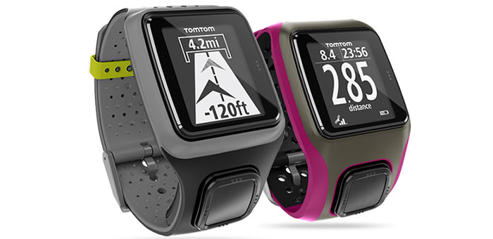
    This summer, TomTom will make available a new range of GPS watches to deliver at-a-glance performance information for runners, cyclists and swimmers. The ultra-slim TomTom Runner and TomTom Multi-Sport GPS sport watches feature an extra-large display, full-screen graphical training tools, and one-button control to make it easier for users to access the information needed to stay motivated and achieve their goals.

    “We know that most GPS watches on the market are too bulky and complicated to use while training,” said Corinne Vigreux, managing director, TomTom Consumer. “Just as we developed easy-to-use navigation products that changed the way that people move from A to B, we have developed a range of ultra-slim GPS sport watches that are far more comfortable to wear and far easier to use. Runners and multi-sport athletes can now view their performance information at-a-glance, making it easier to achieve their fitness goals.”

    The new TomTom watches feature an extra-large, high-resolution and high-contrast display that makes it easy for runners and multi-sport enthusiasts to quickly see their distance, time and pace while they workout even in bright sunshine, TomTom said.

    The new watches feature TomTom’s Graphical Training Partner. Easy-to-read full-screen graphics help users get the most out of their workouts. They can view their real-time performance at-a-glance with three graphical training modes:

    Race: Race against a personal best or most recent run. Quickly track performance with real-time graphics, to continue to improve run-after-run.
    Goal: Set a distance, time or calorie goal and see progress toward that goal with simple, full-screen graphics and alerts.
    Zone: Set a target for pace or heart-rate (with optional heart-rate monitor) and track progress in a simple full-screen graph throughout a workout.

    The new TomTom range includes an intuitive one-button control that enables users to easily navigate up-down-left-right through menus to access key stats and watch features, the company said. Unlike the majority of existing GPS watches on the market that feature multiple small and hard-to-operate buttons, the one-button control is easy to operate while moving and can be easily controlled in all weather conditions and while wearing gloves.

    In addition to their ability to deliver at-a-glance performance information, the TomTom Runner and TomTom Multi-Sport include advanced features designed to address the needs of runners and multi-sport enthusiasts alike:

    Ultra-slim design: At just 11.5mm, the slim design of the watch module comfortably fits men and women, and all wrist sizes.
    Indoor tracker: Accurately track indoor runs using built-in sensors to count strides, so that users can monitor pace and distance even while running on a treadmill.
    QuickGPSFix: Get started faster by using the latest in GPS and GLONASS satellite technology to quickly find their precise location.
    Multi-platform compatibility: Sync, analyze and share stats on popular running sites and community platforms, including the TomTom MySports website, MapMyFitness, RunKeeper, TrainingPeaks and MyFitnessPal.
    Super-tough display: Scratch- and impact-resistant glass stays easy-to-read, workout after workout.
    Weather- and waterproof: Waterproof up to 50 meters/5ATM.
    Long-lasting battery: Up to 10-hour battery life (GPS mode).
    Bluetooth smart: Connect to sensors using the latest wireless technology.
    Heart rate monitor: Use the Bluetooth Smart Heart Rate Monitor to track training zone for weight control, performance or speed.

    TomTom Multi-Sport includes all the features included in TomTom Runner, and also allows multi-sport athletes to track their distance, time, speed and other key metrics when they cycle or swim. The TomTom Multi-Sport is also enhanced with the following features and options:

    Dedicated bike mount: Easily see key stats at-a-glance with the specially designed bike mount.
    Cadence sensor: Track cadence, speed and distance, indoors and out.
    Built-in altimeter: Accurately track elevation, ascent, descent and grade with the built-in barometric altimeter.
    Swimming motion sensor: Check detailed swim metrics such as laps, strokes, time and speed, and calculate a SWOLF score to show swim efficiency.

    The TomTom Runner and TomTom Multi-Sport will be available in Summer 2013.

  • GPSTrackIt Adds Features to Fleet Manager System

    Two new features have been added to GPSTrackIt’s Fleet Manager vehicle tracking system. Route Optimization evaluates the stops in a route and rearranges them to produce the most efficient ordering of the stops. In addition, fleet managers and dispatchers can now compare a route with the actual vehicle trail recorded by the system.

    “Route Optimization has several benefits,” according to Eddie Bermudez, GPSTrackIt’s product manager. “It streamlines the route, which means less time is spent driving around. That saves fuel, which helps you run a greener fleet. It also saves money and improves customer service. Optimizing a route may allow for additional stops to be added.”

    While optimizing a route on the system is one thing, it’s another whether the driver actually drove the route assigned. Fleet Manager’s Vehicle Trails feature can map out Ignition On/Off, Travel Start/Stop, and Drive events for a set date and period. The software has been modified with a route selection list and a button that displays the route superimposed over the vehicle trail.

    “This enables a dispatcher or fleet manager to compare a driver’s plotted route to their vehicle trail,” Bermudez added. “Managers can determine whether drivers are making unscheduled or unauthorized stops.”

    For more information about GPSTrackIt, their new features, or their Fleet Manager vehicle tracking system, visit the website.

  • GPS Block IIF-4 Launch Set for Today

    GPS Block IIF-4 Launch Set for Today

    News courtesy of CANSPACE Listerv.

    Update: The launch window for the liftoff has been adjusted slightly to  21:38-21:56 UTC.

    The United Launch Alliance (ULA) Atlas 5 rocket’s rollout to the pad  took place Tuesday. Weather forecasters have predicted an 80
    percent chance of favorable conditions for launch.

    Updates on the mission and live video coverage of the launch is available.

    Live video will also be available here and on this satellite feed (for those of you still with backyard dishes): SES 2, Transp. 21, C-band, 87° West

    ULA is also posting to Facebook and tweeting to Twitter at twitter.com/ulalaunch; look for the #GPSIIF-4 hashtag.


    The next GPS satellite launch is scheduled for May 15 with the launch window extending from 21:39 to 21:58 UTC. An Atlas 5 rocket will be used to place the satellite, GPS IIF-4, into orbit from Cape Canaveral Air Force Station.

    This is the first time in almost 28 years that an Atlas rocket will be used to launch a GPS satellite. All of the prototype or Block I satellites were orbited with Atlas rockets. Since then, Delta rockets have been used exclusively for GPS launches. The IIF satellites are being launched with a mixture of Atlas and Delta rockets.

    The IIF-4 satellite, also known as SVN66, will operate as PRN27. SVN66/PRN27 will eventually occupy the C-2 slot, replacing SVN33/PRN03, a Block IIA satellite launched in 1996. Reportedly, SVN66/PRN27 will go through an extended period of testing following launch, and is not expected to be set healthy until August. SVN33 will become a reserve or backup satellite.

    Ground Stations: ER = Eastern Range; BOSS = Call sign of New Hampshire   Station, New Boston Air Force Station, New Hampshire; LION = call sign   of Telemetry & Command Station, Royal Air Force Oakhanger, Hampshire,   U.K.; Diego Garcia = Diego Garcia Station (call sign REEF), British   Indian Ocean Territory; Guam = Guam Tracking Station (call sign GUAM),   Dededo, Guam. TDRS: Tracking and Data Relay Satellite MES1: Centaur first main engine start MECO1: Centaur first main engine cutoff MES2: Centaur second main engine start MECO2: Centaur second main engine cutoff At spacecraft separation, the GPS satellite's orbit will be circular   with a height of 11,047 nautical miles or 20,459 kilometers and an   inclination of 55 degrees.
    Ground Stations: ER = Eastern Range; BOSS = Call sign of New Hampshire Station, New Boston Air Force Station, New Hampshire; LION = call sign of Telemetry & Command Station, Royal Air Force Oakhanger, Hampshire, U.K.; Diego Garcia = Diego Garcia Station (call sign REEF), British Indian Ocean Territory; Guam = Guam Tracking Station (call sign GUAM), Dededo, Guam.
    TDRS: Tracking and Data Relay Satellite
    MES1: Centaur first main engine start
    MECO1: Centaur first main engine cutoff
    MES2: Centaur second main engine start
    MECO2: Centaur second main engine cutoff
    At spacecraft separation, the GPS satellite’s orbit will be circular with a height of 11,047 nautical miles or 20,459 kilometers and an inclination of 55 degrees.
    (Courtesy of SpaceFlight Now) This is the 45th Launch Support Squadron crew patch for the GPS 2F-4   mission, which is Boeing's Space Vehicle (SV) #5. Each SV is a named   for a navigation star and its constellation. SV-5 is named Vega, with   constellation Lyra. On the patch, they are the large star and   constellation in the background of space. The United Launch Alliance   Atlas 5 rocket is shown lifting the satellite from the Eastern Launch   Site at Cape Canaveral Air Force Station. The Squadron mascot is a   gator, and a lyra is a Greek harp. SSgt Thomas Hogan drew a   "Toga-Gator" and Lt Ken Stuart did the patch design.
    (Courtesy of SpaceFlight Now) This is the 45th Launch Support Squadron crew patch for the GPS 2F-4 mission, which is Boeing’s Space Vehicle (SV) #5. Each SV is a named for a navigation star and its constellation. SV-5 is named Vega, with constellation Lyra. On the patch, they are the large star and constellation in the background of space. The United Launch Alliance Atlas 5 rocket is shown lifting the satellite from the Eastern Launch Site at Cape Canaveral Air Force Station. The Squadron mascot is a gator, and a lyra is a Greek harp. SSgt Thomas Hogan drew a “Toga-Gator” and Lt Ken Stuart did the patch design.