Author: GPS World Staff

  • CoPilot Brings GPS Navigation to Windows Phone 8

    lumia-920-copilot-ukALK Technologies, provider of navigation and GeoLogistics software, announced at the Mobile World Congress that its CoPilot GPS navigation apps for smartphones and tablets will be available for Windows Phone 8 and Windows 8. The Mobile World Congress is being held in Barcelona, Spain, this week.

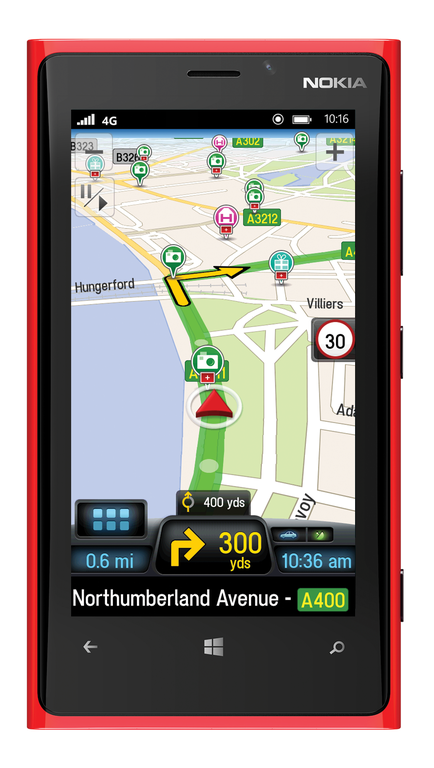
    Designed as an alternative to traditional in-vehicle systems, the app provides voice-guided GPS navigation, with turn-by-turn guidance, comprehensive trip planning and automotive-grade street maps stored on-board the device for offline use. Integral real-time services include ActiveTraffic, Yelp, Wikipedia and Google Search to keep drivers fully informed on the road.

    “We’ve always been fans of Microsoft’s mobile solutions,” said David Quin, head of consumer applications at ALK Technologies. “CoPilot was originally developed for Microsoft’s Pocket PC and pioneered mobile navigation on Windows Mobile, so we are delighted to announce a new app for Windows Phone 8 and Windows 8. The Windows family of mobile devices is rapidly gaining momentum as an alternative to Android and iOS, and provides an ideal platform for us to deliver a full-featured and driver friendly CoPilot navigation experience.”

    “Windows Phone is backed by a vibrant app ecosystem with a variety of quality titles, like CoPilot, which help people enjoy a smartphone that is uniquely theirs,” said Todd Brix, general manager, Windows Phone Apps, Microsoft Corp. “CoPilot is a great example of the rich applications that people can enjoy on their Windows Phones.”

    CoPilot for Windows Phone 8 and Windows 8 provides a suite of advanced navigation features, including:

    • Clear, non-distracting 3D map views with lane arrows and signpost display.
    • ActiveTraffic, which calculates the fastest routes and accurate arrival times based on live traffic flow information.
    • CoPilot ClearTurn for navigating complex junctions.
    • On-screen speed limit indicator and excess speed warnings.
    • Advanced trip planning with a choice of three routes and drag-and-drop route editing.
    • Comprehensive local search with integrated Yelp, Wikipedia and Google.
    • Global map regions available to purchase and store on the device as required.

    CoPilot is expected to launch on the Windows Phone Store and Windows Store in summer 2013 with the following versions: CoPilot Premium, a paid app which includes turn-by-turn navigation and 12 months ActiveTraffic; CoPilot GPS, a free offline trip-planning and maps app with in-app purchase for turn-by turn navigation; and CoPilot Truck for truck-specific GPS navigation. Pricing will be in-line with existing CoPilot apps for iOS and Android.

  • Build Your Own GPS IIF Satellite — with LEGOs

    Build Your Own GPS IIF Satellite — with LEGOs

    So, you thought GPS satellites were only built by government contractors with millions of dollars? Think again.

    A California company that specializes in LEGO kits of space vehicles is offering a GPS IIF satellite kit. The kit, which sells for $45, includes 142 LEGO Bricks, instructions, and a display stand. Once constructed, the model measures 21 1/4-inches from the tip of one solar array to the other, is 2 3/4-inches wide, and 4 1/4 inches tall.

    OK, it’s not space worthy. Or the right size. And it doesn’t produce any signals. But the wings rotate!

    The company, Space Satellite Models, also offers LEGO models of other Department of Defense and NASA satellites.

  • Spectracom Simulator Compatible with China’s Beidou System

    Spectracom has announced its upgrade capability to China’s global navigation satellite system, Beidou. The Spectracom GSG Series 5 and Series 6 GNSS signal simulators, released in 2012, are designed to be field upgradeable to simulate current and future GNSS constellations. GSG simulators are capable of outputting the frequencies, modulations and data formats of anticipated GNSS systems. The January release of the Beidou ICD specification has confirmed that Spectracom GPS/GNSS simulators will be able to emulate these satellite signals with a simple field-upgradeable firmware update.

    “In anticipation of the deployment of these new, major GNSS systems, Spectracom ensures that every GSG simulator that leaves the factory is tested for compliance with all the signal frequency and modulation specifications as defined in their ICDs. Customers who have purchased our Series 5 or 6 simulators since June 2012 have this upgrade capability,” Spectracom CTO John Fischer said.

    Spectracom_GSG-62_W
    Spectracom GSG-6 series simulator. Photo: Spectrum

    The Series 5 single frequency simulator is fully capable of the all the signals in the L1 (GPS and GLONASS) / E1 (Galileo) / B1 (Beidou) band, including all the GLONASS FDMA satellites.

    The Series 6 multi-frequency simulator is fully capable of all four bands of all the systems: L1 / E1 / B1; L2 / L2C; L5 /E5 /B2; and E6 / B3.

    Fischer added, “As the need for new signals arise, firmware upgrades will be available. This ensures our customer’s investment is protected. Galileo signals will be available this year and Beidou will be available next year.”

  • ESA’s Navigation Lab Helps Set Global Time

    The European Space Agency (ESA) is helping to set the world’s time. Ultra-accurate atomic clocks of ESA’s Navigation Laboratory, which will be used to assess performance of the Galileo satnav system, have joined the global effort setting Coordinated Universal Time down to a billionth of a second.

    The replacement for Greenwich Mean Time, Coordinated Universal Time (UTC) is the timing used for Internet, banking, and aviation standards, and other international timescales, maintained by the Paris-based Bureau International de Poids et Mesures (BIPM).

    Participating measurement institutes and observatories around the globe use collections of atomic clocks to estimate a current value for UTC. These clock data are fed through to the BIPM to be carefully weighted and averaged to derive a combined global value. The complexity of this effort is such that it takes around six weeks to arrive at a definitive final figure, ESA said.

    Atomic clocks at ESTEC's Navigation Laboratory. Once Galileo services start, ESA’s Navigation Lab will play an important role independently validating Galileo timing performance. Its atomic clocks, offering precise timings for ESA  missions and experiments, are also contributing to the global setting of Coordinated Universal Time (UTC), the replacement for GMT.
    Atomic clocks at ESTEC’s Navigation Laboratory. Once Galileo services start, ESA’s Navigation Lab will play an important role independently validating Galileo timing performance. Its atomic clocks, offering precise timings for ESA missions and experiments, are also contributing to the global setting of Coordinated Universal Time (UTC), the replacement for GMT.

    ESTEC Director Franco Ongaro has signed an agreement with BIPM to mark the international recognition of the ESA timescale and the addition of ESA’s atomic clock data to the UTC calculations. “This is an independent timing capability that ESA’s Navigation Laboratory — based in ESTEC in the Netherlands — built up to support validation of Galileo timing performances, and before it the experimental Galileo GIOVE satellites,” explained Pierre Waller of ESA’s RF Payload Systems division.

    “But it makes sense to apply it more widely, and this BIPM recognition reflects the quality of our data. Our UTC estimate — formally known as UTC (ESTEC) — is also available for projects within ESA: there are many space applications beyond just navigation, such as precision technical experiments or synchronization of telecommunications and deep-space ground stations.

    “Incidentally, it is important to note that our contribution to UTC does not replace the existing input from the Netherlands’ own national timing metrology institute, Van Swinden Laboratories (VSL) in Delft. Instead we are adding to it, for enhanced global accuracy overall.”

    Galileo, like all other satellite navigation systems, is based on the highly precise measurement of time. A receiver on the ground pinpoints its position by calculating how long signals from satellites in orbit take to reach it.

    Matching the receiver and satellite clocks then multiplying the time taken by the speed of light gives the range between the user and the satellite. This allows the receiver to fix its longitude, latitude and time when in contact with four or more satellites. Atomic clocks on each satellite keep time to a matter of nanoseconds — billionths of a second — synchronized by a worldwide ground network.

  • Broadcom Launches GNSS Chip with Geofence Capabilities

    Broadcom Corporation has introduced the BCM47521, a GNSS chip with architecture that enables geofence capabilities while preserving battery life. According to Broadcom, the new chip opens the door to always-on location-aware applications such as social networking, place-based mobile commerce and local merchant advertising.

    Broadcom will showcase its GNSS innovations at the upcoming Mobile World Congress show in Barcelona, February 25-28.

    A geographical region of interest (“geofence”) is being used by many new and innovative location-aware applications. The geofence feature enables the application to receive a notification when a user enters or exits a virtual perimeter. However, the implementation of this feature in traditional architectures is not viable, as the applications processor needs to run constantly, causing rapid drain to the device’s battery. Broadcom’s new BCM47521 overcomes this issue, making it possible to continuously monitor geofence areas while consuming 60x less battery power.

    “The astounding growth of mobile devices is driving new opportunities for inventive applications that deliver valuable location-aware information,” said Scott Pomerantz, Broadcom vice president and general manager, GPS. “With the BCM47521’s low-power geofence mode, Broadcom is driving the next wave of system power consumption innovation that will allow OEMs to incorporate features that differentiate their mobile offerings and make location-aware, always-on applications a reality.”

    The BCM47521 chip also provides multi-constellation support by simultaneously collecting data from GPS, GLONASS, QZSS and SBAS, and using the best received signals, resulting in faster searches and more accurate real-time navigation, Broadcom said. Broadcom’s multi-constellation technology, coupled with advanced signal processing, provides faster positioning performance for improved user experience, especially in challenging urban environments where buildings and obstructions can dramatically impact accuracy and time-to-first-fix.

    A key feature is the 60x better system power efficiency versus a host-based architecture. An advanced host-offload mode monitors geofences in the background and only activates the applications processor when there is a trigger event, and smart algorithms adapt in real-time as the user gets closer to a geofence boundary.

  • LOCiMobile Launches Enterprise Work Force Tracking App TMWF

    LOCiMOBILE, Inc., a wholly owned subsidiary of GTX Corp, has launched its first enterprise app for companies looking to effectively track and monitor their workforce in real time. Track My Work Force (“TMWF”) is available for download on iTunes, and based on its early success, is in development for release on the Android platform.

    Once downloaded on either an iPhone or iPad, the app works in the background and reports the whereabouts of that device back to the GTX Corp monitoring back-end. The app was designed for small- to medium-sized companies that have a mobile sales or service workforce and need to know the location of their reps in real time. Companies in the U.S., Canada, Czech Republic and Morocco, in industries including transportation, construction, plumbing, IT, medical and pharmaceutical, have already deployed the TMWF app and the GTX back-end monitoring platform.

    Morocco+All
    In January, a pharmaceutical company based out of Morocco that services 25,000 pharmacies across several North African countries deployed TMWF for 150 of its sales reps.

    “Our diamond delivery business relies heavily on our traveling sales representatives in order to maintain relations with existing customers as well as meeting new ones. GTX Corp’s Track My Work Force app was extensively tested during our system trial,” Jack Daynes of the Diamond Group said. “The results were such that we implemented the program immediately and haven’t regretted it in the slightest. Both the pricing and the service that we’ve received have exceeded our expectations.”

    Companies can easily deploy this technology by leveraging the mass adoption of smartphones and tablets in the workforce, said GTX Corp. In January, a pharmaceutical company based out of Morocco that services 25,000 pharmacies across several North African countries deployed the app for 150 of its sales reps.

    “We are very pleased with the initial feedback and potential of this app,” said Patrick Bertagna, GTX Corp CEO. “There are tens of thousands of companies all over the world that can benefit and increase customer service, productivity and security from two-way GPS technology and are now able to implement this technology with a simple download.”

    The TMWF app is an efficient and cost-effective way for business owners and managers to keep track of and manage their mobile work force, GTX Corp said. It’s faster and safer than text messaging and allows the worker to focus on the task at hand rather than spending valuable time calling HQ to check in and report, the company said. The app costs $9.99 initially, with an additional monthly monitoring service fee that costs around $5.00 per user per month.

    The company provides a free two-week evaluation for any business with more than five employees, and custom solutions along with a licensable white-label platform for larger companies.

  • First GLONASS Station Outside Russia Opens in Brazil

    Brazilian_GLONASS_SDMC_stationNews courtesy of CANSPACE Listserv.

    The Moscow Times is reporting that the first overseas GLONASS ground station for differential correction and monitoring was launched in Brasilia, Brazil, on Tuesday, citing information from the Russian Federal Space Agency (Roscosmos). The station will become the first correction point in the Western Hemisphere and will significantly improve the accuracy of GLONASS navigation signals, the agency said.

    GLONASS stations will also be installed in the United States, according to Pravda.Ru. “GLONASS stations are to be installed in the U.S.. This will improve the accuracy of the system. In general, stations like these are planned to be located in more than 30 countries of the world. Most of the countries that received the offers for the installation of the stations responded positively.

    “However, the process is slow because of the need to conclude appropriate intergovernmental agreements. The documents with Brazil were signed in 2012. Agreements with Spain, Indonesia and Australia will be finalized soon,” Pravda.Ru said.

    The Brazilian SDCM station is located on the campus of the University of Brasilia.

  • Trimble Acquires Penmap Software for Survey and Cadastral Markets

    Trimble has acquired a suite of software solutions from Penmap.com Ltd. of Bradford, United Kingdom. Penmap.com’s solutions include both office and field data collection software specifically designed for the cadastral and surveying markets. The comprehensive software suite enables Trimble to further address local application requirements and customer needs by providing complete customized surveying software solutions for the cadastral market, the company said. Financial terms were not disclosed.

    The software solutions include:

    Penmap encore: A new solution specifically designed for PDAs and handheld GPS receivers running Windows Mobile operating system. The software’s revolutionary user-friendly interface takes advantage of virtually the entire display screen to maximize map real-estate and is designed for fingertip operation.

    Penmap encoreT: A new premium data collection software specifically designed for tablet PCs running Windows 8, 7, Vista or XP operating system. Its user interface shows collected data on the map in real-time. This feature gives users peace of mind that they have collected data correctly before leaving the site, Trimble said.

    Penmap Office: An intuitive office platform for Penmap encore software. The office software streamlines the land administration professional’s workflow — from project preparation and importing data to managing large raster and vector background maps collected in the field, Trimble said.

    “Penmap.com has built a very close and successful relationship as a customer of Trimble for many years,” said Erik Schütz, managing director for Penmap.com Ltd. “Since Penmap.com was founded, our vision has been to focus on the local requirements of the regional markets we serve and provide those customers with a fine-tuned and easy-to-use solution. The software is an ideal fit within the Trimble portfolio of solutions to address the cadastral market.”

    “The acquisition of Penmap.com’s software suite of office and field solutions reinforces Trimble’s continued commitment to the cadastral market, as well as our focus on providing customers with complete solutions that are customized for local market requirements,” said Matt Delano, business area director for Trimble’s Land Administration Solutions. “Penmap.com’s strength lies in its ability to customize surveying software applications for regional markets, providing users the most intuitive work processes for optimal efficiency and productivity, making it a perfect fit for our customers.”

  • How to Use GPS to Make a Valentine

    How to Use GPS to Make a Valentine

    Yes, there is a way. According to Krulwich Wonders, an NPR science blog, a man in San Francisco equipped with an iPhone and tracking app rode his bike 27 miles around the city. Two and a half hours later, Payam Rajabi had etched a heart shape onto a city map.

    large-heart-map
    Click to enlarge.

    In 2012, Rajabi had to leave his girlfriend behind in Toronto for a new job. To make sure Clare knew this was a labor of love, Payam included an elevation map of his ups and down in the hilly city.

    This year, Verizon is featuring Rajabi — who repeated the feat for cameras — in a television commercial:

  • Topcon HiPer SR and Pocket 3D Provide Help to Construction Sites

    HiPer SR_construction_Topcon
    Topcon HiPer SR and Pocket 3D in the field.

    With the introduction of a new version of Pocket 3D software for its HiPer SR GNSS receiver, Topcon Positioning Systems is expanding the delivery of high-accuracy 3D positioning technology to contractors needing a low-cost, one-man layout and measurement system.

    Pocket 3D is powerful, easy-to-use data collection and control software for grade checking and other measurement applications on a job site. Version 10.0.2 makes it fully functional with the HiPer SR receiver, introduced in August.

    The new receiver is not only “perfect for contractors, but also for other non-traditional GNSS users such as landscape architects, law enforcement forensics projects or any others requiring high-accuracy 3D positioning,” said Tony Vanneman, Topcon construction products marketing manager.

    Its field-rugged and fully-integrated design delivers a 1,000-foot working radius through Topcon’s new LongLink technology. “This innovative wireless data link was developed specifically for the HiPer SR, and provides reliable and interference-free base-to-rover communications that don’t require an FCC license to operate,” Vanneman said.

    “We took the best signal tracking technologies and packaged them in a small, energy-efficient design,” he said.  “Anyone looking for a rugged, easy-to-use, low-cost 3D GPS system will find what they need in the HiPer SR.”

    Additional key features of the HiPer SR include:

    • Shock-resistant magnesium alloy housing – allowing the HiPer SR to take a 6 ft. (2m) pole drop onto concrete;
    • Weighs 1.8 pounds (0.8kg);
    • 226-channel Vanguard technology, featuring Universal Tracking Channel technology, supports all satellite constellations;
    • Fence antenna technology;
    • Quartz lock loop technology for superior GNSS tracking in high-vibration environments, such as on a four wheeler;
    • Capable of simultaneous LongLink operation with multiple rovers;
    • Sealed battery pack provides more than 15 hours of operation.
  • Urban GPS Navigation Improved 50-90 Percent, Researchers Say

    A new system developed by Universidad Carlos III de Madrid (UC3M) researchers uses sensors to improve the ability of GPS to determine a vehicle’s position compared to use of conventional GPS devices by up to 90 percent.

    The prototype can guarantee the position of the vehicle to within 1 or 2 meters in urban settings, the researchers said.

    The system can be installed in any vehicle for little cost and may eventually work on smartphones, the researchers said. Their findings are described in the report, “Context-Aided Sensor Fusion for Enhanced Urban Navigation.”

    Sensor Fusion. The prototype system incorporates a conventional GPS signal with those of other sensors (accelerometers and gyroscopes) to reduce the margin of error in establishing a location. “We have managed to improve the determination of a vehicle’s position in critical cases by between 50 and 90 percent, depending on the degree of the signals’ degradation and the time that is affecting the degradation on the GPS receiver,” said David Martín, a researcher at the Systems Intelligence Laboratory (LSI – Laboratorio de Sistemas Inteligentes) at UC3M. The system was jointly designed and developed by LSI and the Applied Artificial Intelligence Group (GIAA – Grupo de Inteligencia Aplicada Artificial).

    The margin of error of a commercial GPS, such as those that are used in cars, is about 15 meters in an open field, where the receiver has wide visibility from the satellites. However, in an urban setting, the determination of a vehicle’s position can be off by more than 50 meters, due to the signals bouncing off of obstacles like buildings, trees, or narrow streets. In certain cases, such as in tunnels, communication is lost, hindering the GPS applications reaching Intelligent Transport Systems, which require a high level of security.

    “Future applications that will benefit from the technology that we are currently working on will include cooperative driving, automatic maneuvers for the safety of pedestrians, autonomous vehicles or cooperative collision warning systems,” the scientists comment.

    Integration of GNSS antenna of rover receiver and IMU in a platform over the roof of the vehicle.
    Integration of GNSS antenna of rover receiver and IMU in a platform over the roof of the vehicle.

    The greatest problem presented by a commercial GPS in an urban setting is the loss of all satellite signals. “This occurs continually, but commercial receivers partially solve the problem by making use of the urban maps that attempt to position the vehicle in an approximate point,” Martín said. “These devices can indicate to the driver approximately where he is, but they cannot be used as a source of information in an Intelligent Transport System like those we have cited.”

    The basic elements that make up this system are a GPS and a low-cost inertial measurement unit (IMU). The latter device integrates three accelerometers and three gyroscopes to measure changes in velocity and maneuvers performed by the vehicle. Then, everything is connected to a computer that has an application that merges the data and corrects the errors in the geographic coordinates. Enrique Martí of UC3M’s GIAA explains, “This software is based on an architecture that uses context information and a powerful algorithm (an unscented Kalman filter) that eliminates the instantaneous deviations caused by the degradation of the signals received by the GPS receiver or the total or partial loss of the satellites.”

    The current prototype can be installed in any type of vehicle. It is already working on board the IVVI (Intelligent Vehicle based on Visual Information, pictured above), a car that has become a platform for research and experimentation for professors and students at the university.

    The LSI and UC3M researchers working on this “intelligent car” can capture and interpret all of the information available on the road, and that drivers use. To do this, the team is using optical cameras, infrareds and lasers to detect whether drivers are crossing the lines on the road, or whether there are pedestrians in the vehicle’s path, as well as to adapt the speed to the traffic signals and analyze the driver’s level of sleepiness in real time.

    Next Steps. The researchers will analyze the possibility of developing a system that makes use of the sensors that are built into smartphones, because intelligent telephones are equipped with more than ten sensors, such as an accelerometer, a gyroscope, a magnetometer, GPS and cameras, in addition to Wi-Fi, Bluetooth or GSM communications.

    “We are now starting to work on the integration of this data fusion system into a mobile telephone,” said Enrique Martí, “so that it can integrate all of the measurements that come from its sensors in order to obtain the same result that we have now, but at an even much lower cost, since it is something that almost everyone can carry around in his pocket.”

  • Test Confirms EGNOS + Galileo = Safer Skies

    Test Confirms EGNOS + Galileo = Safer Skies

    Europe’s two satellite navigation systems could combine in the future for heightened performance, an airborne test has confirmed. A helicopter flight took place above an alpine valley in Germany, the one place on Earth where Galileo services are already routinely available.

    The test receiver. The helicopter flew a variety of manoeuvres, from fast loops to mid-air hovering, to see how satnav signals were received in practice.
    The test receiver. The helicopter flew a variety of maneuvers, from fast loops to mid-air hovering, to see how satnav signals were received in practice.

    Results of the flight test, conducted in September 2012, show that adding Galileo signals to the European Geostationary Navigation Overlay Service (EGNOS) should boost its accuracy significantly. EGNOS, which augments the accuracy and reliability of GPS signals over Europe, renders satnav usable for safety-critical applications such as aircraft guidance, as well as more general precision uses.

    Operational horizontal and vertical distance “protection levels” for safety were cut by half by combining use of GPS and Galileo within EGNOS. In addition, new integrity algorithms installed within the user receiver turned out to reliably detect and exclude reflected or otherwise faulty signals.

    The first test of real Galileo navigation fixes is scheduled for later this year from the four satellites already in orbit, with more satellites set to join them by the end of the year.

    EGEP testbed combined GPS/GALILEO
    The Galileo Test and Development Environment – GATE – is a giant outdoor laboratory where prototype Galileo receivers can be used freely without any modifications.

    As the constellation takes shape, satnav researchers and industrial developers can already try out Galileo services with prototype receivers at the German Galileo Test and Development Environment, or GATE, a giant outdoor laboratory. GATE, in and around the town of Berchtesgaden in the Bavarian Alps, is Europe’s go-to place for Galileo testing: transmitters atop eight neighbouring mountains cover 65 square kilometers of territory with simulated Galileo signals.

    ESA’s Global Navigation Satellite System Evolution program carried out helicopter-based testing here on September 24–26. The results will help to guide the development of next-generation satnav systems.

    The helicopter flew a variety of maneuvers, from fast loops to mid-air hovering, to see how satnav signals were received in practice. The test relied on ESA’s SPEED platform — Support Platform for EGNOS Evolutions & Demonstrations, co-funded by French space agency CNES and operated by Thales Alenia Space France — which enabled the receiver to receive simultaneous realtime augmentation for both GPS and Galileo.

    Europe’s next-generation EGNOS, planned for around 2020, is envisaged to operate in the same way, with augmentation of both constellations and dual-frequencies at the same time making the system much more robust.

    EGEP testbed combined GPS/GALILEO
    A helicopter flies over the Galileo Test and Development Environment – GATE – in Berchtesgaden, Germany, gathering data on how EGNOS and Galileo will work together. The promising results from the testing are now being analyzed.