The National Geospatial-Intelligence Agency (NGA) has awarded GeoNorth Information Systems (GNIS) a five-year, $15 million contract for persistent surveillance services of the Arctic region. Lockheed Martin will provide a scalable geospatial processing platform to enable the surveillance project.
GNIS will leverage Lockheed Martin’s Rosetta technology, which includes a versatile and highly automated set of commercial and civil image processing tools that scale and adapt to deliver precision geospatial intelligence products to the NGA.
GNIS, a wholly owned subsidiary of the Tatitlek Corporation, an Alaska Native Village Corporation, will work with Lockheed Martin and the University of Alaska Fairbanks’ (UAF) Alaska Satellite Facility (ASF), under the banner of the Arctic GeoData Cooperative. GNIS and the partners will build, improve, monitor and maintain terrain elevation models of the Arctic region.
“The Arctic region has significant global implications for environmental, economic and security factors,” said Gil Metzger, director of Applied Research at Lockheed Martin. “It is critical that we document and monitor this demanding environment with the best technologies available. Lockheed Martin is proud to be part of this innovative cooperative that establishes both an operational domain awareness capability and a foundation for advanced research.”
The cooperative team will leverage each member’s unique expertise and capabilities to provide a one-of-a-kind solution to partners like the NGA.
As the prime contractor, GNIS will perform overall project management, conduct day-to-day operations and provide access to commercial remote-sensing platforms through its existing direct receiving station located at ASF.
UAF brings broad Arctic-related research and development, problem solving and the ability to refine existing scientific algorithms and methods to support specific project requirements.
Lockheed Martin’s Rosetta toolset will transform the large volumes of sensed data into correlated geospatial intelligence products.
“The Arctic domain poses many challenges,” said Jon Heinsius, general manager of GNIS. “Not only is it an area much larger than the whole United States and Canada combined, but its remoteness, intense weather conditions and unique characteristics are not found anywhere else in the world. The cooperative’s combined academic and commercial approach provides the NGA with tremendous flexibility to meet their current and future needs.”
“The cooperative is going to be a supportive environment where participants can bring ideas, technologies, algorithms and research for development, testing and validation,” said Nettie La Belle-Hamer, director of the Alaska Satellite Facility. “The concept is to explore and nurture new ideas to take what we learn today to build for tomorrow.”
Yang Changfeng, chief architect of China’s BeiDou navigation satellite system. (Photo: BeiDou)
By Yang Changfeng Chief Architect, BeiDou Navigation Satellite System
As one of the core GNSS, the BeiDou Navigation Satellite System (BDS) has been developed following a three-step development strategy. By around 2020, BDS will form a space constellation consisting of 30 satellites, including three satellites in geostationary earth orbit (GEO), three satellites in inclined geosynchronous satellite orbits (IGSO), and 24 satellites in medium earth orbits (MEO). It will provide free open and high-quality services, including navigation, positioning, timing, short message communication, search and rescue, and so on to the users worldwide.
In 2018, BDS has made fruitful results in the aspects of system construction, integrated applications, and international development.
System Construction
The stable operation of the BDS-2 constellation and construction of the BDS-3 constellation have resulted in solid achievements, while the deployment of the ground-based and satellite-based augmentation systems has made remarkable progress, and the International Multi-GNSS Monitoring and Assessment System (iGMAS) has been in stable and continuous operation
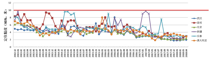
BDS-2 Improved Regional Services. Through upgrades and enhancements of the ground system, the service performance, stability and availability of the BDS-2 constellation has been improved. The analysis results shows that the nominal positioning accuracy of BDS-2 in its coverage area is better than 5 meters. To achieve user-oriented services, the Interface Control Document (ICD) for the open service signal B3I has been released.
The basic system of iGMAS has been completed, consisting of 24 ground stations and various centers, to provide raw data, basic products, and monitoring and assessment information services to users through the Internet and smartphones.
BDS-2 Positioning Performance. (Chart: BeiDou)
BDS-3 Constellation Deployment. By late 2018, 16 MEO BDS-3 satellites and 1 BDS-3 GEO satellite were in orbit. China successfully launched the 18th and 19th BDS satellites on Nov. 19. Deployment of the basic BDS-3 constellation has been accomplished.
The BDS-3 satellites are equipped with the higher-performance rubidium atomic clocks with stability of E-14 as well as hydrogen atomic clocks with stability of E-15. The signal-in-space (SIS) accuracy will be superior to 0.5m, the position accuracy will reach 2.5 to 5 meters, and the overall performance will be dramatically improved. The in-orbit test results have indicated that the BDS-3 satellites are in sound condition, and the performances can satisfy nominal parameters. For the convenience of public applications, the ICDs of the new signals, B1C and B2a, have been released.
BDS-3 will inherit the short message communication service from its predecessors, and will further enhance the basic PNT service capabilities. Satellite-Based Augmentation System (SBAS) and Search and Rescue (SAR) services will be developed according to the international standards.
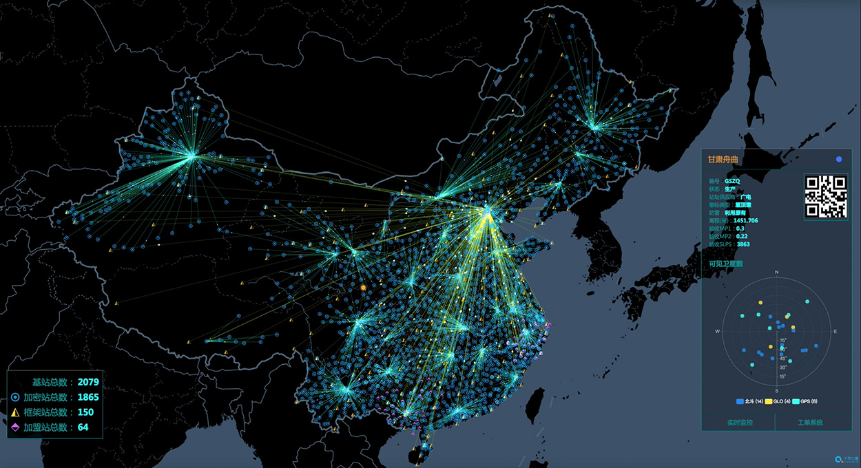
Ground-Based Augmentation. The BDS/GNSS Ground-based Augmentation System has completed the deployment of 155 framework reference stations and nearly 2,400 regional stations in China. The system has carried out high-precision applications in many fields, such as surveying, national resources, disaster mitigation, transportation, meteorology, and offered basic services for users, including real-time navigation services at meter-level and decimeter-level, as well as precise positioning services at centimeter-level and millimeter-level.
China’s National Reference Station Network. (Image: BeiDou)
First SBAS GEO Satellite. The BeiDou Satellite-based Augmentation System (BDSBAS) is being developed in accordance with the International Civil Aviation Organization (ICAO) standards, to offer navigation services with superior accuracy and integrity.
In November 2018, the first GEO satellite with SBAS and SAR payloads has been successfully launched. The short message communication service offered by the satellite will be fully compatible with that of BDS-2, while the service volume will be increased by 10 times and the user’s transmit power will be reduced to 1/10. As the result, the user terminals will possess smaller size, higher integration and enhanced capacity.
Integrated Applications
As the system construction accelerates, BDS is also making great efforts to strengthen the development of fundamental products and applications in various fields. The integrated applications adopt the “BDS+” model, to stimulate the growth of satellite navigation industry.
Fundamental Products. At present, the fundamental BDS products have been used in mass market applications, of which the performance has reached or close-to the world-class level. By the 3rd quarter of 2018, the sales volume of BDS navigation chips and modules exceeded 70 million pieces, and the amount of the BDS-enabled terminals surpassed 500 million pieces or sets. In 2017, the domestic output value is more than RMB 250 billion (US $ 36 billion), in which the BDS contribution exceeds 80%.
Industrial Applications. BDS continues to facilitate the integrated applications and development of related industries; to bring GNSS high-precision services in combination with cloud computing, internet of things, big data and other technologies; to push forward the fusion among BDS-related industries and high-end manufacturing, software, integrated data industries, and to enable BDS-based applications to solve the problems associated with national economy and people’s livelihood. BDS has been integrated into various national significant infrastructures, by providing time and space references for transportation, meteorology, agriculture, electricity, communications, finance and other industries.
Meanwhile, “BDS+” and “Time and Space+” applications targeted towards the mass market are enjoying a broader future prospect. The BDS-based navigation services have been adopted by various enterprises in the fields of smart mobile terminal manufacture, location-based services (LBS), e-commerce, and so on. The BDS-based LBS have been widely use in the public consumption sector and people’s livelihood, which have been changing people’s life by providing more conveniences for the public.
BDS International Development. BDS continuously pushes forward international development, carries out practical cooperation and exchanges, and promotes the development of GNSS community, to better serve the world and benefit mankind.
BDS actively participates in related activities under the framework of the United Nations, other international organizations and multilateral platforms. In June, 2018, BDS took part in the UNISPACE+50 Exhibition and donated a BDS-3 satellite model to the United Nations Office for Outer Space Affairs.
In November 2018, the 13th Meeting of the International Committee on Global Navigation Satellite Systems (ICG-13) was successfully held in Xi’an, China. His Excellency Xi Jinping, President of the People’s Republic of China, sent a congratulatory letter to the ICG-13, and expressed that “China is willing to work with all countries, to share the construction and development achievements of BDS, and to jointly promote the development of global satellite navigation.” More than 400 representatives from 16 nations and 16 regional and international organizations attended the meeting and made in-depth exchanges on over 20 topics related to satellite navigation.
BDS has always been exploring joint applications with other compatible navigation satellite systems, and carrying out bilateral coordination and cooperation.
In November 2017, the Joint Statement of BDS and GPS Signal Compatibility and Interoperability was signed, which stated that the two systems were radio-frequency compatible within the framework of ITU, and BDS B1C civil signal and GPS L1C civil signal had achieved interoperability.
In November 2018, the Agreement between the Government of the People’s Republic of China and the Russian Federation on Cooperation in the Field of the Use of BDS and GLONASS for Peaceful Purposes was signed, which would facilitate the complementarity and integrated development, promote practical cooperation projects, and contribute to more efficient and reliable services for global users.
At present, BDS has covered more than 50 countries and over the population of 3 billion people. The BDS-related products have accessed to the markets of over 80 countries and regions. In April, 2018, the first overseas BDS/GNSS Center was opened by China Satellite Navigation Office and the Arab Information and Communication Technology Organization, to enrich the public awareness, experience and applications of BDS in Arab nations.
The international GNSS Monitoring and Assessment System (iGMAS) has contributed to the implementation of the Asia-Pacific Space Cooperation Organization project, iGMA-International GNSS Service Pilot experimental project, and Sino-Russian monitoring and assessment cooperation, and has provided GNSS users with authentic third-party assessment results.
Future Plans
BDS will continuously promote joint applications of multiple navigation satellite systems, and provide global users with diversified choices for better application experiences. BDS welcomes users and equipment providers worldwide to participate in the Global Users’ Experience and Evaluation Campaign (relevant information can be referred to the BDS official website), and will release the experience and evaluation results when appropriate.
By the end of 2018, BDS-3 will possess the initial operational capability and implement all-round validation on its global service performance. Between 2019 and 2020, BDS will keep improving its continuous stability and service accuracy, maintain the BDS-2 service performance stable and enhanced, and continue the BDS-3 deployment by launching another 6 MEO satellites, 3 IGSO satellites, and 2 GEO satellites, to eventually possess global service capabilities by 2020.
As part of ongoing global expansion, Microdrones has merged with Schübeler Technologies. Since its founding in 1997, Schübeler has built a global business by providing advanced fan propulsion jets and lightweight composite materials fabrication.
Offering a full product lineup of robust turbo fans, jets, compressors, pumps, electric motors, carbon fiber and aluminum composites, Schübeler products are designed to withstand extreme conditions and demanding field use. These components provide thrust power and lightweight durability to high-tech applications including UAVs, professional motorsports and heavy-duty outdoor equipment.
Microdrones, founded in 2005, has evolved from a manufacturer of commercial-grade unmanned VTOL aircraft to a provider of fully integrated systems for surveying, mapping, lidar and inspection applications. These systems are being put to use worldwide by professionals in the construction, mining, energy, agriculture and infrastructure trades.
“We make life easier for professionals by offering the full solution; it has proven to be a successful strategy,” said Microdrones President Vivien Heriard-Dubreuil. “Perfectly integrated drones, sensors, software, workflow, training and support is what the market needed. Welcoming the Schübeler team, talent and capabilities to Microdrones delivers new aviation technology and capabilities to our customers in the form of next generation unmanned aircraft.”
As the preferred provider of VTOL solutions to Trimble Dealers worldwide, Microdrones adds a global sales force and distribution network as well as technical centers and production sites spanning seven countries and three continents.
“Merging with Microdrones empowers us to develop and deliver systems where we can best support customers locally,” said Daniel Schübeler, founder and CEO of Schübeler Technologies. “This is a happy homecoming for me and the team that we’ve built over the past 20 years.”
Schübeler was an original founding partner in Microdrones and helped develop the pioneering technology that helped Microdrones gain global recognition for professional VTOL UAVs. He adds, “Both of these companies have enjoyed global growth and impressive technological advancements independently. Merging our talents and teams will yield amazing solutions in the years to come.”
“This is a strategic growth initiative,” explained Francois Gerner, SVP of Corporate Affairs at Microdrones. We are adding technology, IP, talent, strong leadership and investment capabilities that are complementary to both brands. This deal brings us to more than 150 highly skilled employees worldwide, which translates to better products, service and support.”
The merged companies will retain the Schübeler Technologies brand, which commands a niche’ audience of serious aeromodeling enthusiasts. Schübeler Technologies will continue to serve these markets as well as tackle large-scale custom R&D projects related to propulsion and materials.
After many years of development at the fringe of the GNSS industry, dual-frequency GNSS devices are finally ready to hit the mass market and will account for more than a billion chipset shipments in 2023, according to a new market data report by ABI Research.
ABI Research is a market-foresight advisory firm.
The report finds that the bulk of this growth will come from the adoption in the smartphone market with consumers hungry for better location accuracy.
Dual-band GNSS can mitigate the multipath interference effects, which are especially present in areas with a high density of buildings, like urban canyons, and deliver significantly higher accuracy than single-frequency devices.
Broadcom’s BCM47755 chip. (Image: Broadcom)
However, several obstacles prevented widespread adoption of dual-band GNSS until now, including insufficient satellite coverage of a second band, which could be L2 or L5/E5, high chipset prices, and challenges in fitting these integrated circuits and related antennas into small devices such as smartphones.
“On the availability side, this year has seen several satellites launched into orbit every month, most of them fitted with L5/E5 capabilities, and the Chinese and European Union governments plan to have their satellite constellations fully operational by 2020. L5/E5 devices will not be left in the dark,” said Henrique Rocha, a research analyst for Location Technologies at ABI Research.
Furthermore, new breakthroughs from key chipset manufacturers are disrupting this market by overcoming the barriers to mass dual-frequency adoption. With Location-Based Services (LBS) applications in mind, Broadcom has released the BCM47755 dual-band location hub, claiming the system’s architecture achieves the synergistic benefits that cannot be reached by multiple integrated circuits (ICs), thereby reducing its overall size and power consumption.
Other important players in this market have also come forward with dual-frequency solutions, including Qualcomm with the Snapdragon X24 LTE modem and HiSilicon with the Kirin 980 system-on-a-chip. Both attribute their superior energy efficiency and form factor to intelligent data processing and a FinFET transistor design. Other chipset manufacturers such as MediaTek are expected to follow suit and present their own dual-band products for LBS.
The Xiaomi Mi 8. (Photo: Xiaomi)
At the consumer level, considering the handset market is the largest GNSS segment, accounting for 85 percent of all GNSS chipset shipments in 2018, the launch of the dual-frequency Xiaomi Mi 8, Xiaomi Mi Mix 3 and the Huawei Mate 20 following such breakthroughs in the chipset industry is a significant development because it opens a new lane of competition between smartphone manufacturers.
It is expected that dual-frequency devices will dominate the high-end smartphone market in a matter of a few years, and by 2023 dual-band GNSS ICs will comprise 36% of total GNSS LBS IC shipments worldwide.
Triple-frequency chips. In other significant markets for multi-frequency GNSS, such as surveying and automotive applications, triple-frequency chipsets are being released, including STMicroelectronics’ TeseoAPP and u-blox’s F9. Adding a third frequency allows for better noise correction and higher accuracy compared to dual-frequency.
Image: u-blox
ABI Research believes that triple-frequency devices will see, at least for now, a relatively shy adoption as manufacturers will need to justify the cost and overcome the power issues they tackled for dual-frequency devices.
“For LBS the comparatively small accuracy gain going from dual- to triple-frequency GNSS is not worth the extra effort — for now. However, we will probably see triple-frequency GNSS take off when cars fitted with advanced driver assistance and autonomous driving systems begin to ship in large quantities,” added Rocha.
With full satellite operability of the main GNSS bands on the horizon and chipset manufacturers overcoming past hurdles for implementing dual-frequency solutions, it is likely a matter of time before most major companies in the segment scramble for a piece of this promising market. OEMs now need to show customers that dual-frequency GNSS can indeed deliver the accuracy they have promised so new location use cases can be sustained and introduced to the market.
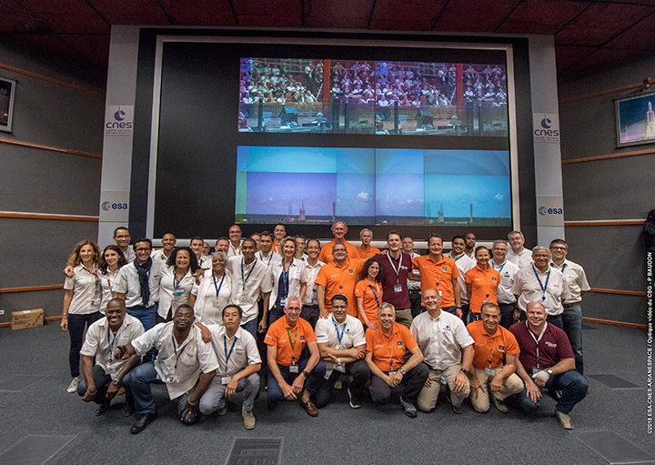
Countdown team at Kourou, Guiana control center for July’s four-satellite launch. (Photo: ESA/CNES/Arianespace, P. Baudon)
By Javier Benedicto Head, Galileo Programme department, European Space Agency
Since the declaration of initial services in December 2016, the European Space Agency (ESA) and the European GNSS Agency (GSA) have expanded Galileo’s system capabilities and service robustness with significant improvements of the ground segment and the last batch of four satellites launched by Ariane 5 in July. Once these satellites reach their final position and complete their in-orbit commissioning before the end of 2018, all 24 nominal slots of the Galileo constellation will be occupied.
Up to 22 satellites are planned to be commissioned in early 2019 and, eventually, the two FOC satellites injected in elliptical orbit should join the operational constellation after on-board software upgrade to provide for automatic health status flagging to users. This should lead to a total of 24 operational Galileo satellites supporting global PNT for users worldwide.
New Infrastructure Contracts
To further expand the system capabilities by 2020 and beyond, and reach Full Operational Capability (FOC), ESA has awarded new large industrial contracts in the context of the Exploitation Phase.
A contract to build and test another twelve Galileo satellites (so-called Batch-3) was awarded in 2017 to a consortium led by prime contractor OHB GmbH in Germany, with Surrey Satellite Technology Ltd in the UK as payload prime. These new satellites are based on the already qualified design of the previous Galileo FOC satellites. Production is advancing well, with first launch planned by late 2020.
With the Galileo constellation now expanded to 26 navigation satellites and plans to deploy additional Batch 3 satellites, the ground control infrastructure is undergoing a corresponding upgrades. In July, ESA awarded a new contract for the Galileo Ground Control Segment to GMV Aerospace and Defence, Spain. This contract includes upgrading the system architecture to manage a constellation of up to 41 Galileo satellites, updating obsolescent elements in the current system, improving operability linked to the provision of services and additional telemetry, tracking, and command capabilities to improve system robustness.
In October, Thales Alenia Space in France received a contract to upgrade the Galileo Ground Mission Segment and the Galileo Security Monitoring Centres (GSMC). This work includes upgrading Galileo’s system architecture to provide more accurate navigation products for broadcast by Galileo satellites, updating obsolescent elements in the current system and improving operability linked to the provision of services and enhanced robustness.
It will also include the construction of additional navigation message uplink and sensor stations. This contract will also augment the capabilities for implementation of the Public Regulated Service (PRS), the single most accurate and secure class of Galileo signals. Encrypted PRS signals will be made available only to authorized governmental users through approved national authorities. GSMCs in France and Spain will ensure the security monitoring functions for Galileo operational assets and manage PRS access and operations.
Growing Service Portfolio
The European Commission, GSA and ESA have jointly defined a broad range of service improvements and system capability enhancements to be deployed in 2019–2020, leading to FOC.
The newly qualified system infrastructure will support the broadcast of authentication information as part of the Open Service Navigation Message in E1; experimentation will start by end of 2019, leading to the possibility to offer trusted PNT to Galileo users.
Galileo will also be the first GNSS constellation to provide a Search and Rescue return link capability: as of 2019 the system will allow broadcast of acknowledgement of receipt message to users in distress with a very low latency, contributing to saving lives.
ESA has also started preparing the necessary modifications to the Navigation Signal Generation on-board the satellites to offer further capabilities to users after 2020. The signal-in-space will be enhanced with additional data transmitted in the I/NAV message, offering faster acquisition and more robust Galileo positioning on E1 and an encrypted navigation signal on E6 supporting authentication at signal level.
The new Galileo High Accuracy Service, soon entering the experimental phase, will consist in the delivery of un-encrypted high accuracy correction data in E6, enabling users to achieve sub-meter level positioning.
The usage of Galileo Open Service for aviation applications using horizontal advanced receiver-autonomous integrity monitoring techniques is being carefully assessed through measurements and review of the system design, including feared-events characterisation.
Longer Term Evolution
Galileo Second Generation has been the subject of technology pre-developments in the areas of platform and payload critical equipment, system techniques and processing algorithms, as well as system and segment Phase B studies over the past few years. We are now approaching the start of the implementation phase.
The European Commission, in close consultation with EU member states, has defined a decision roadmap aiming at very important future budget and programme implementation decisions in the course of 2019. In this context, ESA has launched a competitive procurement procedure for the first batch of so-called “Transition Satellites” with a broad range of enhanced and some new capabilities being considered. This includes improvements in the signal domain for faster acquisition and lower receiver power consumption, on-board clock technology, inter-satellite links, electrical propulsion, flexible payloads and power allocation by means of on-board digital technology and in-orbit re-configurability.
Transition satellites and related ground segment development contracts will begin by the end of 2019, aiming at in-orbit validation of second-generation capabilities from 2025 onwards.
EGNOS Evolution for Aviation
The adoption of Europe’s SBAS EGNOS by aviation is growing faster and faster. EGNOS will continue to evolve in the coming years. In particular, for 2019 and 2020, the evolutions under implementation focus on the obsolescence management of the hardware of some critical components, improvement of the system performances thanks to addition of new stations and system algorithms.
All these evolutions are planned to be qualified in 2021-2022, to continue to offer an excellent level of performance to Aviation Users until the operational take-over by the second generation of EGNOS V3,planned in 2025.
The European Performance-Based Navigation Implementing Regulation plans a growth from the current 35% to 66% in 2020 and 100% in 2024 of all European airports instrumental runways end-equipped with SBAS localizer performance with vertical guidance procedure.
On the aircraft manufacturer side, Airbus confirmed that it will continue equipping its aircraft; following the A350 family already equipped, both A320 and A330 families will be equipped for entry into service in summer 2020.
NAVISP
ESA’s Navigation Innovation and Support Programme (NAVISP), launched in 2017, will continue to boost member states’ industrial competitiveness and innovation in the upstream and downstream navigation sector, investigate the integration of satellite navigation with non-space technologies and complementary positioning and communication techniques, and study novel receiver-based techniques to counteract vulnerabilities and improve the robustness and reliability of GNSS.
Conclusion
The EU-built GNSS infrastructure systems EGNOS and Galileo are operational and serving users in Europe and worldwide. EC, GSA, ESA and European industries are committed to improvement plans over the next 2–3 years, with emphasis on endurance, resilience and robustness of the systems’ infrastructure, and delivering enhanced services.
For the longer term, the real challenge is to modernize the systems with new spaceborne and ground technologies, increase operational robustness and automation, and provide for additional system capabilities, while retaining a large degree of flexibility and in-orbit re-configurability to meet the long-term challenges and evolution of satellite-based navigation and timing.
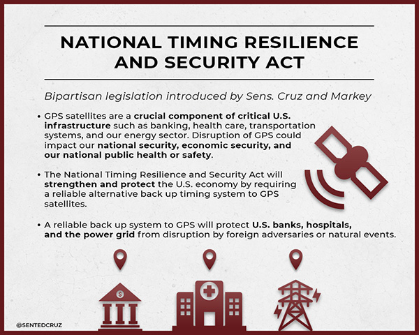
On Dec. 4, President Trump signed the Frank LoBiondo U.S. Coast Guard Authorization Act of 2018. Included in that bill was the National Timing Security and Resilience Act of 2018.
The act tasks the Secretary of Transportation with establishing a terrestrial backup timing system for GPS within two years.
Further, the bill ensures the availability of uncorrupted and non-degraded timing signals for military and civilian users in the event that GPS signals are corrupted, degraded, unreliable, or otherwise unavailable.
The law requires that, to the maximum extent possible, the backup system be:
terrestrial
wireless
synchronized to UTC
difficult to disrupt
able to penetrate underground and inside buildings
capable of deployment to remote locations
expandable to provide position, navigation and timing (PNT), and
able to work in concert with similar systems such as eLoran.
It also has provisions for the government to be able to establish the system through a commercial entity should it elect to do so. In such a case, it establishes several provisions that such a contract must meet.
Image: @SENTEDCRUZ
Timing a critical area. Timing has been an area of increasing focus and concern for both industry and government.
The U.S. Alliance for Telecommunications Industry Solutions (ATIS), the standards body for the wireless industry, has cited GPS timing as a point of failure for wireless systems. Last year ATIS wrote to key senators, encouraging them to establish an eLoran system to provide a second and much more resilient timing source for America.
In 2015 and 2016, the U.S. National Institutes of Standards and Technology issued reports that said America’s timing infrastructure was insufficient to support the growing internet of things (IOT).
The bill was sponsored by a broad coalition in the House led by Congressmen John Garamendi (D-CA) and Duncan Hunter (R-CA). Senators Ted Cruz (R-TX) and Ed Markey (D-MA) led the effort in the Senate, where the bill passed with an overwhelming majority.
U.S. Sens. Ted Cruz (R-Texas) and Ed Markey (D-Mass.) issued the following statements. “Establishing a reliable alternative timing system to GPS satellites is crucial to the national and economic security of the United States,” Sen. Cruz said. “If the current system were disrupted for even just a few hours, there would be an immediate threat to the American people, the economy, and our very way of life. Thankfully, Congress recognized the importance of addressing this issue. I am grateful for Sen. Markey’s leadership, and commend President Trump for signing this bill into law.”
“The nation’s banking, communications, electricity, and transportation sectors rely on the precise timing provided by GPS,” Sen. Markey said. “We cannot allow this vital system to be imperiled by natural phenomenon like solar flares or coordinated attacks like jamming. I am so proud that President Trump has signed this important bill into law, and I thank for Senator Cruz for partnering on policy that will enhance the resilience and reliability of this critical infrastructure.”
Defense attempt. Similar legislation that would have placed the responsibility for a terrestrial GPS backup system with the Department of Defense was introduced in 2015. While this was done with the acquiescence of senior DOD leadership, when the department later determined it did not want the responsibility, the measure failed.
While this new law is not a funding bill, Congress provided $10M for a technology demonstration in 2018. Also, having a law in place requiring the system paves the way for funding in future appropriations bills.
Rohde & Schwarz and Huawei have successfully conducted cellular-based 5G V2X latency measurements in vehicular environments in field tests in Munich and Shanghai.
In a joint project between Huawei and Rohde & Schwarz, a precision end-to-end delay measurement system for over-the-air IP transmissions was applied to 5G V2X communication for cooperative driving applications in field tests in a moving car.
The precision absolute time standards on both ends were derived from two independent GPS receivers.
URLLC will enable automated driving. (Image: Rohde & Schwarz)
The initial measurements show that it is possible to achieve delays in the millisecond regime in a 5G network, demonstrating superior latency performance in comparison to LTE.
One of the key use cases of 5G is ultra-reliable low-latency communication (URLLC). Important for advanced vehicle-to-X communication use cases, URLLC will enable automated driving in the future.
A measurement accuracy below 2 µs for each transmitted IP packet was demonstrated. The transmitted data contained various IP traffic streams including video, lidar and control data (ITS messages) for a tele-operated vehicle.
While the trial in Munich was related to a tele-operated driving project, the tests in Shanghai were related to a platoon V2X testing site, where a number of vehicles traveling together are electronically connected via wireless communication.
The delay for transmission of one IP packet from source over-the-air to a (moving) receiver (sink) needs to be measured, spanning all delays introduced by the radio transmitter, propagation delay and radio receiver from/to IP packet level.
As latency is one of the key performance indicators of 5G and crucial for safety applications, such measurements could become an important criterion for future certification testing.
“We are delighted to collaborate with Huawei to contribute with our test and measurement expertise to 5G technology development,” said Andreas Pauly, executive vice president, Test & Measurement at Rohde & Schwarz. “With a strong global footprint in the telco ecosystem and close cooperation with partners, Rohde & Schwarz is committed to further expanding our innovative test and measurement solutions to new automotive applications.”
Certificate of Networthiness accreditation affirms U.S. Army’s use of Boundless Desktop for battlespace awareness in warfighter missions.
Boundless Desktop has received the U.S. Army Certificate of Networthiness (CoN), an accreditation that ensures the product meets Department of Defense (DoD) and Army guidelines, regulations and requirements. The CoN verifies compliance with stringent DoD and Army requirements for security, sustainability and usability.
Boundless Desktop is a native, cross-platform desktop geospatial information system (GIS) built upon proven open source software, including QGIS, PgAdmin, Qt Designer and GDAL/OGR. The product builds maps, manages data, models and analyzes, and disseminates results with users globally.
Desktop is used to conduct geospatial analysis to include creation of common operating pictures, route and area analysis, and other geospatial intelligence operations.
Desktop integrates government and geographic standards for cartographic styles and rules, combines and models spatial data in ways that generate new insights through workflow modeling, provides analytical tools and scripts for terrain and data analysis, and provides access to various open source formats for data and product sharing.
Federal agencies are collecting and storing more location data and imagery than ever before, and timely and accurate geospatial intelligence is critical to making decisions that impact safety, security and quality of life. Public accountability means that agencies must be mindful of directing costs away from necessary tasks.
Boundless provides federal agencies with enterprise-grade, fully supported versions of proven open source software along with reliable, expert help from feature development to production support. Interoperability is built right in, ensuring that geospatial data and analysis is accessible across agencies and divisions, the company said. Open source technology offers the flexibility needed to leverage geospatial data now and when needs or demands change. Expenses are predictable and manageable, freeing resources for mission-critical operations.
“The use of automated data analysis and analytical tools is essential for developing situational awareness and a common operating picture of battlespace in our warfighter missions,” said Jason Lee Smith, security specialist, Counter Explosive Hazards Center, U.S. Army Fort Leonard Wood. “Timely and accurate geospatial intelligence provided by Boundless allows us to make mission-critical decisions that impact safety and security, and the software’s flexibility and interoperability means that we can consistently rely on it both in our day-to-day operations and when there are spikes of activity.”
“Boundless is committed to delivering open and scalable GIS solutions that empower our users to understand the world around them through geospatial intelligence,” said Andy Dearing, CEO, Boundless. “The Army CoN assures that Boundless Desktop is safe, sustainable and easy for federal agencies to use, and we’re proud to have achieved this validation for our solutions in the federal government space.”
Audi, Airbus and Italdesign presented for the first time a flying and driving prototype of Pop.Up Next, a flying taxi. The companies demonstrated the concept at Drone Week, held Nov. 27-29 in Amsterdam.
The concept combines a self-driving electric car with a passenger drone. In the first public test flight, the flight module accurately placed a passenger capsule on the ground module, which then drove from the test grounds autonomously.
Photo: Audi
The demonstration was done with a 1:4 scale model. But as soon as the coming decade, Audi customers could use the flying taxi service in large cities — in multi-modal operation, in the air and on the road, without changing vehicles.
“Flying taxis are on the way. We at Audi are convinced of that,” said Bernd Martens, Audi board member for sourcing and IT and president of the Audi subsidiary Italdesign. “More and more people are moving to cities. And more and more people will be mobile thanks to automation. In future senior citizens, children, and people without a driver’s license will want to use convenient robot taxis. If we succeed in making a smart allocation of traffic between roads and airspace, people and cities can benefit in equal measure.”
To see what an on-demand service of this kind could be like, Audi is conducting tests in South America in cooperation with the Airbus subsidiary Voom. Customers book helicopter flights in Mexico City or Sao Paulo, while an Audi is at the ready for the journey to or from the landing site.
“Services like this help us to understand our customers’ needs better,” Martens said. “Because in the future, flying taxis will appeal to a wide range of city dwellers. With Pop.Up Next we are simultaneously exploring the boundaries of what is technically possible. The next step is for a full-size prototype to fly and drive.”
Audi is also supporting the Urban Air Mobility flying taxi project in Ingolstadt. This initiative is preparing test operations for a flying taxi at Audi’s site, and is part of a joint project of the European Union in the framework of the marketplace for the European Innovation Partnership on Smart Cities and Communities.
The project aims to convince the public of the benefits of the new technology and answer questions concerning battery technology, regulation, certification and infrastructure.
Rolls-Royce and Finnish state-owned ferry operator Finferries have successfully demonstrated a fully autonomous ferry in the archipelago south of the city of Turku, Finland.
The car ferry Falco used a combination of Rolls-Royce Ship Intelligence technologies to successfully navigate autonomously during its voyage between Parainen and Nauvo. The return journey was conducted under remote control.
During the demonstration, the Falco, with 80 invited VIP guests aboard, conducted the voyage under fully autonomous control. The vessel detected objects utilizing sensor fusion and artificial intelligence and conducted collision avoidance. It also demonstrated automatic berthing with a recently developed autonomous navigation system. All this was achieved without any human intervention from the crew.
The Falco is equipped with a range of advanced sensors which allows it to build a detailed picture of its surroundings in real time. The situational awareness picture is created by fusing sensor data and it is relayed to Finferries’ remote operating centre on land, some 50 kilometres away in Turku city centre. Here, a captain monitors the autonomous operations, and can take control of the vessel if necessary.
During the autonomous operation tests in Turku archipelago, Rolls-Royce has so far clocked close to 400 hours of sea trials. The Rolls-Royce Autodocking system is among the technologies that have been successfully tested. This feature enables the vessel to automatically alter course and speed when approaching the quay and carry out automatic docking without human intervention. During the sea trials, the collision avoidance solution has also been tested in various conditions for several hours of operation.
Earlier this year Rolls-Royce and Finferries began collaborating on a new research project called SVAN (Safer Vessel with Autonomous Navigation), to continue implementing the findings from the earlier Advanced Autonomous Waterborne Applications (AAWA) research project, funded by Business Finland.
“Today marks a huge step forward in the journey towards autonomous shipping and reaffirms exactly what we have been saying for several years, that autonomous shipping will happen,” said Mikael Makinen, president – Commercial Marine at Rolls-Royce. “The SVAN project has been a successful collaboration between Rolls-Royce and Finferries and an ideal opportunity to showcase to the world how Ship Intelligence technology can bring great benefits in the safe and efficient operation of ships.
“This is a very proud moment for all of us and marks our most significant milestone so far. Today’s demonstration proves that the autonomous ship is not just a concept, but something that will transform shipping as we know it.”
“We are very proud that maritime history has been made on the Parainen-Nauvo-route once again,” added Mats Rosin, Finferries’ CEO. “First with our world-renowned hybrid vessel Elektra and now Falco as the world’s first autonomous ferry. As a modern ship-owner, our main goal in this cooperation has been on increasing safety in marine traffic as this is beneficial for both the environment and our passengers. But we are also equally excited about how this demonstration opens the door to the new possibilities of autonomous shipping and safety.”
The Falco is a 53.8 metre double-ended car ferry, which entered service with Finferries in 1993. It is equipped with twin azimuth thrusters from Rolls-Royce.
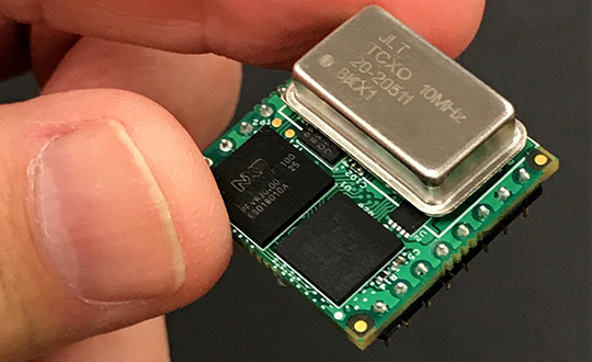
Jackson Labs Technologies Inc. (JLT) released its tiny, new Micro-Transcoder, a full-constellation, stand-alone, real-time 10-channel GPS simulator. The unit can act as a GPS firewall to identify and block jamming and spoofing attempts, and to provide an alternate PNT source during fully GPS-denied operation.
JLT is a designer and manufacturer of GNSS, timing and frequency equipment.
Photo: JLT
The one-inch-square Micro-Transcoder module allows glueless retrofitting of existing GPS equipment by upgrading systems with secure and assured positioning, navigation and timing (PNT) capability, the company said. It achieves hardening of the customers’ GPS equipment by splicing the unit in between the existing antenna and the users’ GPS receiver.
It takes the output of any secure PNT source — inertial navigation system (INS), SAASM, M-code, Iridium STL, or concurrent GNSS receiver — and encodes (RF modulates) the baseband PNT and UTC timing information into a standard GPS L1 RF signal.
This RF signal can then be received by any legacy GPS receiver.
The unit is based on JLT’s CLAW GPS simulator and RSR transcoder technologies, and includes a stand-alone full-constellation 10-channels real-time GPS simulator with integrated high-stability timing reference, as well as an internal GNSS receiver for monitoring the RF output signal for quality and accuracy.
The unit will transmit a standard UTC time, position, velocity and heading GPS L1 RF signal by simply applying 3.3V power to it.
The Micro-Transcoder can also be operated as a generic high-performance GPS simulator with built-in GPS Disciplined Oscillator, and is supported by a comprehensive free Windows application program downloadable from the JLT website.
The Windows application allows control of all the simulation aspects, creating and storing simulation vector commands, and testing user equipment for leap-second and GPS week rollover event compatibility to identify weaknesses in user equipment.
The unit does not require a PC to be connected to it to function. This makes embedded operation as easy as applying power, and connecting the units’ RF output to the antenna input of any GPS receiver.
By generating a legacy RF GPS signal from any secure PNT source, the Micro-Transcoder allows users to maintain their investment in fielded legacy GPS equipment. Example applications include retrofitting financial transaction time servers with CSAC or rubidium atomic clock holdover capability, and adding GPS RF output capability to concurrent GNSS receivers to allow reception of L1, L2, L3, L5 GPS, GLONASS, Galileo, BeiDou, QZSS, Iridium STL, or any other satellite-based navigation signal to legacy GPS receivers.
It can also be used to add inertial navigation system (INS) capability to vehicles and aircraft.
None of these applications require any modifications to be made to the legacy GPS receiver system; all configurations are done externally using the Micro-Transcoder Windows application or a standard terminal program, and on the assured PNT source.
A real-world customer application is a data-center where communications equipment required a GPS signal to operate. The user wanted to prevent vulnerabilities that an external antenna would have introduced. In this scenario, the Micro-Transcoder provided a fixed-position GPS RF signal to a number of the data centers’ GPS receivers, and allowed the GPS user equipment to operate properly without exposing it to the possibility of external jamming or spoofing.
At 0.97 x 0.97 x 0.4 inches and with less than 0.95W power consumption, the Micro-Transcoder is small enough to be designed into emerging assured PNT products, allowing them to communicate gluelessly to existing legacy GPS infrastructure.
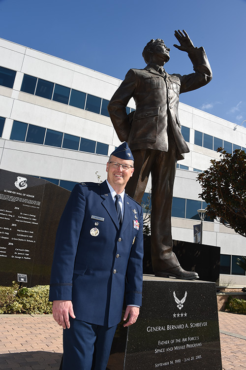
Col. Steve Whitney stands beside a statue of General Schriever at Los Angeles Air Force Base, home of the GPS Directorate. (Photo: U.S. Air Force/Joseph Juarez, Sr.)
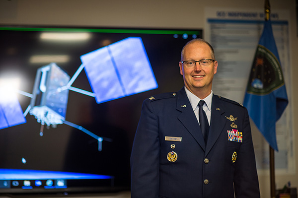
By Col. Steven Whitney Director, Global Positioning Systems Directorate
Navigating across the world’s roads with GPS is easy. Navigating through the shifting construction zones, detours, and forks of the GPS Enterprise is not always so straightforward.
For that reason, the GPS Directorate has placed more emphasis on illustrating, both figuratively and literally, the roadmaps leading to the integration of the GPS Enterprise.
Before linking everything together, let’s start with an update on each major program effort. This way you can zoom out to see the path ahead; hopefully minimizing any “route recalculating” along the way.
Program Updates
The journey to build the new GPS III satellites has been full of twists and turns but we are now close to our destination – in this case the GPS orbit of 12,550 miles above the Earth.
We not only have 10 GPS III Space Vehicles simultaneously in production at Lockheed Martin’s manufacturing facility in Waterton, Colorado, but are also going full swing on preparations to launch our first vehicle in December 2018 on a SpaceX Falcon 9 rocket – more on this later. The GPS III satellites provide signals designed to improve the user’s ability to navigate.
In addition to the increased power and greater accuracy, GPS III adds a civil new signal, L1C, designed for compatibility with the international Global Navigation Satellite Systems (GNSS) community.
GPS IIIF. In September 2018, the Air Force awarded the GPS III Follow-on contract to Lockheed Martin. This $7.2B contract for 22 satellites was the result of a competitive process for a production effort. Based on the GPS III technical baseline, the GPS IIIF family of satellites embraces modernization and capability improvements in multiple areas.
First, a Regional Military Protection capability will provide increased anti-jam capabilities. Furthermore, a new Search-and-Rescue (SAR/GPS) payload will provide improved timeliness of global search-and-rescue operations. Additionally, a Laser Retro-reflector Array (LRA) payload will enable precise ranging measurements and the program will implement a Unified S-Band capability to address consolidation of telemetry, tracking, and commanding frequencies.
Finally, the program will host a redesigned Nuclear Detonation (NUDET) Detection System (NDS) solution that has a lower overall size and weight. We look forward to the continued partnership with Lockheed Martin and will be looking collaboratively at opportunities to add additional capabilities incrementally over the life of the 22 GPS IIIF satellite production line.
OCX, the Next Generation Operational Control Segment. Last year Raytheon delivered the initial system, known as OCX Block 0, to support the launch and on-orbit check-out of the GPS III satellites. This past year, we have actively utilized the system in a variety of exercises, training events, compatibility tests, and launch readiness events.
We also completed a comprehensive security review of the system to demonstrate our readiness to start operations. The system is ready to go. We continue to work the development of the OCX Block 1 system and are wrapping up the initial coding of the system early in 2019, leading into our integration and test campaign.
The journey over the past few years has been challenging, but we have emerged stronger, armed with better metrics, and a culture of integrated development (often called DevOps) which puts us on a path to success. There will be challenges and risks in the path ahead but rather than mountains to climb, I see these more as standard blocking and tackling of a software intensive program.
Col. Whitney next to an artist’s depiction of a GPS III satellite in orbit. (Photo: U.S. Air Force/Van Ha)
Legacy Ground Sustainment. Running in parallel to these modernization efforts is the all-important work to sustain our existing GPS infrastructure of our current Operational Control System (OCS). These sustainment efforts ensure GPS continues to be the gold standard in positioning, navigation, and timing but also are a crucial “on-ramp” to facilitate a smooth merge onto the modernized GPS capabilities.
Since 2014, the GPS program office has incrementally implemented several upgrades that not only maintain our satellite constellation delivery of GPS signal-in-space accuracy of 50 cm, but also significantly increases the cybersecurity posture of the legacy OCS.
These upgrades culminated with a deployment of the latest modification in October 2018, which finished a worldwide modernization of our entire control system hardware and software. This latest upgrade, known as Version 7.5, virtualized the network, implemented two-factor authentication, and improved encryption for mission data.
Legacy Ground Improvements. Given the delays in OCX, the Directorate is actively working two major upgrades to OCS to bridge the gap. The first is GPS III Contingency Operations (COps) modification which will allow the 2nd Space Operations Squadron (2SOPS) to command and control the GPS III family of vehicles in a mission state matching today’s legacy signals for all users world-wide. The second modification is M-Code Early Use, which enables 2SOPS to operationalize the Modernized GPS military signals (M-Code) navigation signals for the warfighter.
User Equipment. As I write this article, soldiers, sailors, marines and airmen are testing and integrating mature, next-generation GPS receiver cards providing more accurate and reliable position, navigation, and timing (PNT) solutions. In 2019, the first increment of Military GPS User Equipment (MGUE) is on track to complete card-level testing to inform Service procurement strategies.
This exciting work is the culmination of nearly two decades of modernization efforts throughout the GPS Enterprise. In the near term, we are utilizing M-Code capable lead platforms — USAF B-2 Bomber, USMC Joint Light Tactical Vehicle, USN Arleigh-Burke Class Guided Missile Destroyer, and Army Stryker combat vehicle — to prove out those capabilities.
The second increment of MGUE focuses on requirements for precision guided munitions, a joint common modular handheld unit, as well as circuit cards and components for low size, weight and power needs. With MGUE, the DoD and services are poised to have enduring PNT solutions the warfighter can leverage for years to come.
Integration Roadmaps
The delivery of individual programs is the stepping stone in the capability deliveries to the warfighter and our civilian users. However, it is our ability to unite a diverse collection of programs and stakeholders, across the GPS Enterprise, which defines our success as the GPS Green Monsters. We have done this by linking cross-program enterprise teams so the sum of the whole is greater than its parts.
Enterprise Road to Launch (ERTL). The goal is pulling together a series of firsts (new satellite, new ground system, and new launch provider), which has not been done before in the modern GPS Era, to deliver the spacecraft safely on-orbit and under control. Our journey to this historic launch has taken time and effort, and we are enthusiastically awaiting the final steps.
The first GPS III spacecraft is safely at Cape Canaveral and ready to go. The control system has been tested and run through its paces. The integrated launch team has conducted its exercises and reviews. All signs point to launch in December 2018.
The launch itself is a significant milestone, and marks a beginning of the orbital phase of GPS III. The Road to Launch team is prepared to execute the launch, the check-out and the day-to-day on-orbit housekeeping until the ground updates are complete to transfer the new GPS III satellite into the active constellation later in 2019.
Enterprise Road to Mission (ERM). The goal is bringing the GPS III satellites into the active constellation providing mission similar to today’s capabilities. A key enabler of the ERM IPT’s success is their development of the first-ever Enterprise “Integration Playbook”, which is the tangible, documented output of a significant dedicated planning effort.
The Playbook captures how all the pieces and efforts from each stakeholder community tie together to achieve Operational Acceptance of the first GPS III satellite, the USNDS payload, and the COps modification to OCS. The “Playbook” describes in clear and concise terms how these deliveries integrate across the GPS Enterprise, as well as how tasks and milestones from various stakeholders converge to achieve clear end states.
Enterprise Road to M-Code Mission, or ERM-M-Code. Shifting now to our military users, the purpose of the ERM-M-Code team is to lead the early delivery of a more robust, resilient, jamming/tampering-resistant PNT signal capability to warfighters.
The rollout of the operational M-code capability depends on the success of the M-Code Early Use modification to OCS, installation of new M-code signal monitoring equipment at sites around the globe, modification of mission planning software, Military GPS User Equipment Increment 1 development, service lead platform integration efforts, and operationalization of space receivers.
Our ultimate objective is to improve the ability of the Combined Space Operations Center (CSpOC) to respond to urgent PNT needs of the combatant commanders, as they engage more sophisticated adversaries. We remain closely aligned with our peers at USSTRATCOM, AFSPC and user communities.
Conclusion
It is an exciting time to be a GPS Green Monster! These roadmaps are by no means easy to create and execute. It is thanks to the remarkable people of your GPS Directorate that these multifaceted challenges are unraveled, aligned, and resolved. The team has worked incredibly hard this past year to position our systems for major, integrated deliveries over the next couple of years.
It has been the highlight of my career to serve with these men and women and I can’t wait to see where we — and the GPS Enterprise — go next.