“As of today [Nov. 28] Tesla owners have driven 1 billion miles with Autopilot engaged,” the company announced via tweet.
The Autopilot feature became available in 2015 and now comes on all new Tesla models with a $5,000 activation fee at the time of purchase or $7,000 if selected later.
The company is training its “neural networks” to improve its self-driving system.
Photo: Tesla
Tesla’s global fleet totals more than half a million vehicles, and recently marked a 20-billion mile step of total electric miles driven, the company said.
The Autopilot system can also function in the background of the vehicle, without being activated and with no input on control. Thus it gathers data from many more billions of “drivered” miles about its environment and potential Autopilot behavior.
The company previously mentioned the 1 billion-mile autonomous mark as the minimum it would need to move Autosteer from beta to a regular feature.
Updates to Autopilot are planned for 2019, including new hardware that will aid in the rollout of the company’s Full Self-Driving system, possibly by the end of that year.
Exploring a wide area in search of a hazardous substance emitting source or expansion of a fire front is an ideal UAV mission. Wildfire monitoring missions exemplify such a problem.
Most multi-UAV systems address problems related to search in an environment of interest. The UAVs cooperate and share data to obtain information within a certain aspect of the environment.
Regardless of the number of UAVs and size of the area of interest (AOI), cooperative systems deliver a perfectly up-to-date picture of the environment with coordination.
This paper investigates a coordination scheme for missions facing uncertainty about the periphery in the AOI. It takes into account the UAVs’ state, observations, the overall mission, and allocates each UAV to a specific task, enabling the multi-UAV system to act in a coordinated manner.
If a coordination algorithm for an environment with uncertainty is available, the overall system still leans on sensing capabilities. Even if the system uses the most advanced sensors, sometimes the environmental conditions are restrictive; that is, UAV sensors cannot reach far enough, and measured data can only be local and quantized data.
The goal of quantized estimation is to develop techniques to effectively reconstruct the data. The research approach relies on a technique for estimation of propagated boundary with quantized measurements and proposes a new class of one-dimensional estimator: the Greedy Uncertainty Suppression (GUS) strategy.
The monitoring application involves large numbers of possibly randomly distributed inexpensive sensors, with limited sensing and processing. The estimator incorporates observations gathered by multiple observers and uses the quantized kalman filter estimation to update the expected location and unobserved spreadrate.
A roundup of recent products in the GNSS and inertial positioning industry from the December 2018 issue of GPS World magazine.
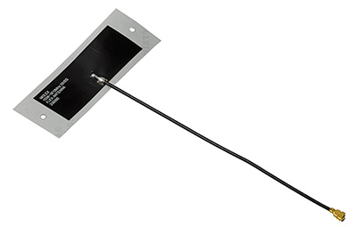
OEM
Combination antenna
Long-range connectivity
Photo: Molex
The Molex highly compact 2.4/5-GHz combination GPS/Wi-Fi ceramic antenna is designed to be a cost-competitive solution covering the full GNSS band, 1.561 to 5.85 GHz. The triple-band ceramic antenna has Wi-Fi HaLow compatibility and is interference-resistant, supporting larger but lower (900-MHz) frequency ranges than 2.4/5-GHz connections. It also operates with lower power over longer ranges than 2.4/5-GHz Wi-Fi. Advanced Wi-Fi applications the internet of things, connected cars, smart homes and smart cities.
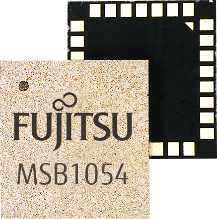
The MSB1054 multi-receiver module requires no external components, meeting needs of smartwatches, fitness trackers, logistics and navigation. Its Flash memory saves navigation data to optimize performance and provide a hot start. The ability to receive signals from several satellite systems significantly reduces the time to first fix. The module provides a built-in RF-front end (SAW filter, low-noise amplifier) as well as a temperature-compensated crystal oscillator (TCXO), so no external component is required other than an antenna. It measures 5.8 × 6.2 × 1 millimeters and uses 3.4 mA current in low-power mode, such as for tracking.
The GE310-GNSS is an internet of things (IoT) module with GSM/GPRS, multi-constellation satellite positioning and Bluetooth functionality in a 270-millimeter-squared form factor. It meets European demand for GSM/GPRS compact form factors and is part of Telit’s migration-support program that helps customers leverage 2G’s low cost and broad coverage while preparing for 4G and 5G. The GE310 enables OEMs and system integrators in asset management, utilities and telematics to meet the strong demand for low-cost, highly compact devices without tradeoffs in performance, reliability and functionality, particularly in regional markets such as Europe, where 2G is forecast to remain in strong growth in number of IoT connections for many years.
With multi-sensor fusion positioning and orientation
Photo: Unicore
The CLAP-B multi-GNSS/MEMS integrated inertial navigation board features a miniaturized high-performance inertial measurement unit (IMU) on a compact high-performance GNSS board. The high-accuracy GNSS positioning coupled with a high-precision gyro and accelerometer provides stable, continuous 3D position, velocity and attitude, as well as original acceleration and angular velocity measurements, even in GNSS-denied environments. CLAP (Concurrent Localization & Attitude Pilot) technology is a high-precision multi-sensor fusion positioning and orientation technology developed by Unicore. The board is compact, light weight and has low power consumption. It is designed for ease of integration and mass production, and is suitable for autonomous driving, smart surveying and UAVs.
The UNI-GR1 RTK GNSS receiver offers highly accurate heading and positioning output. It can be connected to any device through Wi-Fi, mobile data, radio, USB or serial cable. It simultaneously tracks GPS L1/L2/L5, GLONASS L1/L2, Galileo E1/E5a/E5b and Beidou B1/B2/B3 on 432 channels. The receiver has a built-in level, a LED ring driven by a nine-degrees-of-freedom inertial measurement unit. Users can configure numerous settings such as real-time kinematic, or begin surveying immediately with a smartphone or laptop.
Dynamic tilt functionality has been added to the Trimble SPS986 GNSS smart antenna. The dynamic tilt upgrade allows for faster data collection to enable construction surveyors to create larger digital terrain models faster and with improved accuracy. It can capture higher accuracy measurements on steeper slopes from a moving vehicle and more accurate volume measurements to save time and money on material planning. The dynamic tilt measurement mode also auto-measures antenna height. From inside the vehicle, contractors can set the height of the antenna and quickly interrogate surface models using the real-time 3D surface display in Trimble Siteworks field software.
The Skycatch Edge1 is an on-premise data processing and GNSS base station optimized for the Skycatch Explore1 and DJI Phantom 4 RTK drones. Field teams can fly a drone, process the data and receive centimeter-level data output in 30 minutes or less, directly to a tablet, without the need for internet or cellular connectivity. 2D maps and 3D point clouds can be shared from the tablet. The Edge1 includes built-in WiFi, LTE and reliable sub-5-centimeter accuracy, and delivers high-quality data output. It is also capable of running deep learning algorithms to extract more insights from collected data in near real time.
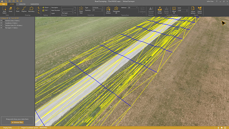
Drone surveying software Virtual Surveyor now eliminates the need for clients to use third-party applications to prepare data for processing. Version 6.1 handles on-the-fly projections that previously required a separate software package to set the data in the proper coordinate system. It bridges the gap between UAV photogrammetric processing applications and engineering computer-aided design (CAD) packages. The software generates an interactive onscreen environment with UAV orthophotos and digital surface models where the surveyor selects survey points and breaklines to define the topography, creating highly accurate topographic products for CAD input up to five times faster than otherwise possible. Surveyors can drag and drop all kinds of files into Virtual Surveyor: points, raster, vectors and point clouds. The point clouds are converted to a DSM for manipulation and processing, dramatically accelerating the time required to generate the CAD model.
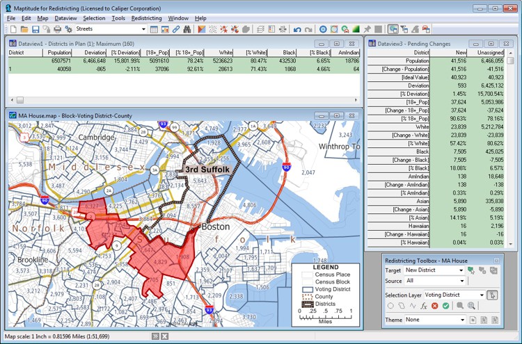
Includes Efficiency Gap Measure to explore redistricting problems
Screenshot: Mapitude
Maptitude for Redistricting is a professional tool for political redistricting. Maptitude provides measures and reports that support the creation of fair and balanced districts, and regularly enhances the software. Maptitude was used to democratize redistricting in California and is used by redistricters from independent commissions, non-profits, and civil rights groups, to the courts and political parties.
Stockpile measurements are up to 80% more accurate
Photo: DJI
The DJI Mavic 2 Pro drone is now part of the Kespry stockpile measurement solution for mining and aggregates companies. Kespry’s stockpile measurement solution produces data up to 80% more accurate than manual measurement. All of the survey data is stored in a central cloud application, accessible for analysis by the entire team. Large aggregates and mining companies can standardize and capture stockpile data across all their sites in the Kespry platform, while using Kespry 2s or DJI Mavic 2 Pro drones.
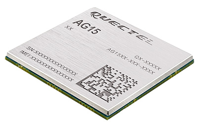
Designed for next-generation automotive applications
Image: Quectel
The automotive-grade C-V2X module AG15 features the Qualcomm 9150 C-V2X chipset paired with Quectel LTE module AG35. It is designed to meet the telematics and vehicle-to-everything (V2X) connectivity requirements of autonomous driving and road safety. It features a built-in multi-constellation high-precision GNSS (GPS/GLONASS/BeiDou/Galileo/QZSS) receiver with additional support from satellite-based augmentation systems (SBAS) and Qualcomm 3D dead-reckoning technology, which improves positioning accuracy and speed while simplifying customer designs. It is designed to allow low-latency, highly reliable and highly dense data exchange between vehicles and their surroundings, enabling effective information sharing among road users to avoid collisions, thus improving automotive safety, automated driving and traffic efficiency.
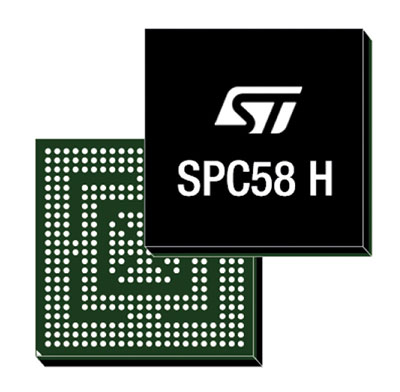
The SPC58 Chorus H microcontroller (MCU) line can run multiple applications concurrently to allow more flexible and cost-effective vehicle electronics architectures. The line is designed for high-end body, networking and security applications such as gateways, body-control modules, battery management and ADAS safety systems. The line has three high-performance processor cores, more than 1.2-MB RAM and powerful on-chip peripherals. The MCU securely delivers updates over the air for vehicle powertrain, body, chassis and infotainment features. With high security and large on-chip code storage, ST’s Chorus automotive microcontroller is a gateway/domain-controller chip capable of handling major OTA updates securely. Two independent Ethernet ports provide high-speed connectivity between multiple Chorus chips throughout the vehicle and enable responsive in-vehicle diagnostics.
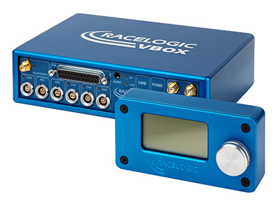
The VBOX 3i RTK is a real-time-kinematic-enabled version of the VBOX 3i dual antenna that can be used in conjunction with an RTK differential base station to obtain ±2-centimeter positional accuracy in real time at 100 Hz. The data logger combines the advantages of a twin antenna GPS setup with GLONASS satellite tracking. It can be used in vehicle tests where positional accuracy and repeatability are of key importance, such as lane departure testing, distance to a fixed object or precise mapping. The VBOX 3i RTK comes with the VBOX manager, a display enabling users to change dynamic modes and filter settings, set up slip angle data and define antenna locations.
The StarLink TrackerWi‑Fi advanced vehicle-tracking device combines u-blox GNSS, 4G and Wi-Fi technology, eliminating the need to equip vehicles with a separate mobile Wi‑Fi hotspot. StartLink is suitable for applications for connected cars, telematics, vehicle diagnostics, fleet management, vehicle security, usage-based insurance, and rental and leasing service companies. With the Wi‑Fi hotspot, users can tap into cellular 4G to transfer telematics data to the fleet manager and send real-time data to the driver’s smart device or infotainment system.
The Notilo Plus team with the iBubble. (Photo: Notilo Plus)
Notilo Plus has launched iBubble, a fully wireless, autonomous and intelligent underwater drone that can be used for search-and-rescue operations, naval or underwater infrastructure maintenance, and subsea patroling. iBubble can accompany divers for up to an hour and down to 197 feet depth, enabling superior underwater imaging. The remotely operated vehicle (ROV) was designed using a patented underwater localization technology, which is mainly based on acoustic signal transmission and image recognition (video tracking). By combining these technologies, iBubble is able to locate precisely its target underwater and shoot stable footage. The iBubble is equipped with an obstacle avoidance system, real-time image recognition, a stabilization system and direct surface control.
Anafi Work is an ultra compact tool for professionals, helping them make informed decisions using the drone’s aerial insights. Anafi Work includes the advanced Anafi drone equipped with an innovative imaging system, a 4K/21MP camera with a 180° vertical orientation, allowing users to capture images of inaccessible areas.The drone operates for 1 hour and 40 minutes with its 4 USB-C smart batteries. It can be transported anywhere in a compact shoulder bag. Professionals can create 3D models of buildings, quickly and easily, using a one-year subscription to Pix4Dmodel.
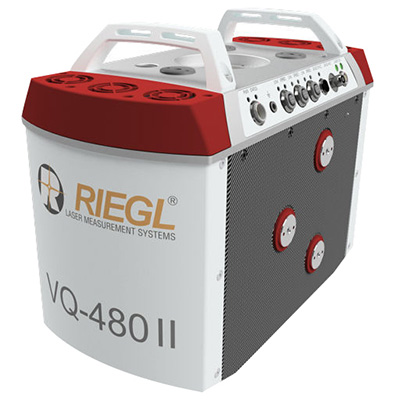
The Riegl VQ-480 II and VQ-580 II are designed for airborne applications at mid-altitudes for use on both manned and unmanned aircraft. The new Mark 2 designs of previous models improve both performance and user-friendliness. Both offer a measurement rate of up to 1,250,000 measurements/second and a 75-degree field of view of suitable for corridor mapping, city modeling and applications in agriculture and forestry. Weighing approximately 10kg, they are ready for integration into helicopters and unmanned UAVs with a higher payload capacity. The VQ-480 II and VQ-580 II are prepared for smooth GNSS/IMU integration, offer interfaces for up to five optional cameras, and are have built-in and removable storage.The VQ-480 II works at a laser wavelength of 1550 nm; the VQ-580 II at the1064 nm wavelength suited to measure on ice and snow.
DroneNode is a portable, compact and inconspicuous counter-drone jamming device that law enforcement can use at large outdoor events without raising public concern (it is not yet authorized for use in the U.S.) It can simultaneously jam 2.4 GHz, 5.8 GHz and GNSS L1 and L2 bands up to one kilometer, causing drones to return to their point of origin or land. It is also effective against swarm attacks. Emergency broadcasts, cellphone communication and other dedicated channels are unaffected.
Skydio R1 users now have the ability to follow cars. New modes include Car Follow, improved Lead Mode, and other improvements throughout the system, which is built on top of the Skydio Autonomy Engine. The engine operates 13 cameras, enabling it to map and understand the world in real time, allowing it to be fully autonomous and independently capture video footage. Its Nvidia Jetsonl AI runs neural networks that trained for the Car Follow feature on datasets of automobile images.
Photogrammetry software Correlator3D was used for a large-scale project by First Base Solutions, announced software developer SimActive Inc.
The software allowed the processing of 50,000 large-format images at 200 megapixels, collected at a 10-centimeter resolution, on a single standard PC, the company added.
The size on disk for each image was 765 MB, for a total of 40 terabytes of raw data. Aerial triangulation was performed and digital surface models (DSMs), digital terrain models (DTMs) and orthomosaics were created, leading to more than 100 terabytes of output.
“We are impressed by the software speed and capabilities on large datasets,” said Brian Leggat, project supervisor of First Base Solutions. “Another advantage is SimActive’s support to quickly help us during our projects.”
First Base has been a user of the software for more than 10 years.
Services of the Quasi-Zenith Satellite System (QZSS) officially started on Nov. 1, according to a statement from Japan’s National Space Policy Secretariat, Cabinet Office.
Government and industry hope the turn-on will generate new services worth nearly 5 trillion yen ($44.4 billion) by 2025 as players like SoftBank Group, Mitsubishi Electric and Hitachi plan applications in automated driving, farming and more.
“Our lifestyles would be impossible without GPS,” Prime Minister Shinzo Abe said at initialization ceremony marking the start of the service. The Michibiki satellite constellation, known officially as QZSS, would let Japan turn “a new page in history,” he continued.
The system keeps at least one of the current four Michibiki satellites over Japan at all times, offering an advantage over GPS-only services with a precise bird’s-eye view uninterrupted by mountains or tall buildings. With special receivers, the satellites can narrow margins of error to 10 centimeters.
The signal is free for anyone with a device capable of receiving the signal.
Prime Minister Shinzo Abe delivers a congratulatory address as QZSS is officially launched. (Photo: Japan Cabinet Public Relations Office)
Japan’s cabinet and other government bodies have invested 120 billion yen in QZSS. Expectations are particularly strong for applications in the rapidly advancing field of automated driving, with some businesses estimating the market for positioning services in that field alone at roughly 500 billion yen.
QZSS offers lane-level positioning capability, is a key step towards auto autonomy.
Michibiki means guidance in Japanese. In his remarks, Abe said the satellite-based augmentation system (SBAS) “will guide us to Society 5.0, the society of the future. There are high hopes for the ever greater use of this satellite system in a wide range of fields. The government aims to expand the system to a seven-satellite constellation by FY2023, with the goal of achieving an even more stable positioning service.
“More than 10 years have passed since its conception. I am sure that taking on this challenge, the first of its kind in the world, must have required much hard work. I would like to express my utmost respect for the efforts of the engineers responsible for the development and all those involved with this project.
“To what degree will the ‘Michibiki’ change our lives? I hope to follow its progress with great excitement, together with you all.”
The Advanced Rapid Imaging and Analysis (ARIA) team at NASA’s Jet Propulsion Laboratory in Pasadena has produced a map showing the damage caused by the Camp Fire in Northern California.
After two and a half weeks of historic destruction, the fire is now 100 percent contained. Teams continue to search the destruction — including the destroyed town of Paradise — for remains. As of Sunday, the death toll is 85, making it California’s deadliest fire.
The map shows the damage as of Nov. 16.
Credits: NASA/JPL-Caltech
The map was developed using synthetic aperture radar images from the Copernicus Sentinel-1 satellites operated by the European Space Agency.
The map covers an area of 48 miles by 48 miles (78 by 77 kilometers), outlined in red on left. A closeup view of damage to the town of Paradise is inset on right, outlined in white. The color variation from yellow to red indicates increasingly more significant changes in the ground surface.
The ARIA team creates its maps by comparing before-and-after satellite images of the fire region to see the extent of change between the two images. For this map, they compared the data for the image to a Cal Fire map for preliminary validation.
Although the maps may be less reliable over vegetated terrain, such as forests, they can help officials and first responders identify heavily damaged areas and allocate resources as needed.
Sentinel-1 data were accessed through the Copernicus Open Access Hub. The image contains modified Copernicus Sentinel data (2018), processed by ESA and analyzed by the NASA-JPL/Caltech ARIA team.
By Senior Airman William Tracy, 50th Space Wing Public Affairs
The 2nd Space Operations Squadron took formal command of Architecture Evolution Plan 7.5, the largest GPS architectural change in operational history, after its successful installation at Schriever Air Force Base, Colorado, Nov. 16.
“AEP 7.5 is a milestone in GPS history and improves our cybersecurity capabilities and postures us to better operate in a contested, degraded and operationally limited environment,” said 1st Lieutenant Jonathan Campbell, 2nd SOPS assistant operations flight commander.
The 2nd SOPS installation replaced 600,000 lines of code in AEP and implemented more than $29 million worth of hardware and software changes.
Additionally, AEP 7.5 sets the platform for the installation of AEP 8.0, which will deliver the capability to command and control GPS III satellite vehicles — the first GPS III satellite scheduled to be launched from Cape Canaveral Air Force Station, Florida, next month.
Campbell said AEP 7.5 is a significant step up from the previous AEP 7.3, with overall improvements allowing Airmen to command and control satellites with better efficiency.
The program’s successful installation was the result of extensive training from a Mission Operations Transfer at the squadron’s Alternate Master Control Station at Vandenberg Air Force Base, California. Both rotations of the Space Mission Force crew structure were activated to ensure full operational capabilities at both sites, performing security control assessments on the system and taking other measures.
“Training consisted of acclimating to AEP 7.5, learning how to navigate it and utilize it to the best capability,” said Senior Airman Ryan Lape, 2nd SOPS satellite systems operator. “Because our constellation was so big, upon taking command at Schriever we had to iron out the changes on a large scale.”
Campbell said the hard work was worth it — the successful installation and command of AEP 7.5 through the squadron’s efforts will prepare for changes in the near future.
“This will provide combat ready space warfighters delivering position, navigation and timing to optimize the full range of Air Force, joint force and civilian operations, across all domains,” he said. “The updated hardware provided in the AEP 7.5 installation lays the foundation for a software update next year enabling the command and control of GPS Block III vehicles.”
Campbell added not only will the installation advance the 2nd SOPS’s mission, but the 50th Space Wing’s as well, helping evolve space and cyberspace warfighting superiority through integrative and innovative operations.
“The capabilities provided in this update, and those coming in the next year, provide a significant improvement to our warfighters,” he said.
With this milestone, Campbell said the continuation of the U.S. military’s dominance in position navigation and timing systems is secured.
“This update furthers the U.S. military’s and Schriever AFB’s position as the center of satellite command and control and space operations,” he said.
Lape said the milestone will make an impact outside of the military as well.
“We are the premier PNT system in the world with the largest satellite constellation,” he said.
“With measures like these, it will definitely make our adversaries think twice.”
The 2nd Space Operations Squadron operations floor is a flurry of activity during 2nd SOPS’s formal command of Architecture Evolution Plan 7.5. (Photo: USAF/Senior Airman William Tracy)
Recently launched satellites of BeiDou Phase 3 program have started broadcasting new signals. Javad GNSS announced successful tracking of these signals and provided the adjacent figures.
Interface control documents (ICDs) for B1C and B2A signals are available, while an ICD for the other signal, called B2B, has not yet been published. The company tracked the signal on the 1207.14 Mhz frequency on BeiDou’s satellites 32, 33 and 34, and subsequently saw that this signal is available on all recently launched BeiDou Phase 3 satellites, and tracked it successfully.
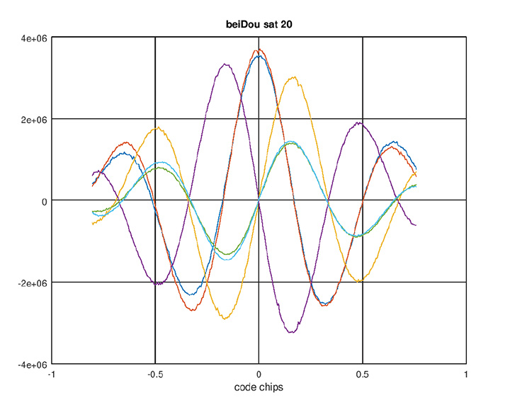
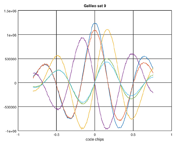
This B2B signal plus B2A signal together form an AltBOC(10,15) signal on 1191.795 MHz — JAVAD GNSS calls it BaltBOC. Assuming that BOC parameters of this signal are similar to Galileo’s, the company tracked this. Figures 1 and 2 show BeiDou andGalileo (BaltBOC and altBOC) discriminator curves; they appear identical.
Figure 1. BeiDou AltBoC signal. Red and blue: I of B2A(E5A) and B2B(E5b) sub-signals; purple and yellow: Q of B2A(E5A) and B2B(E5b) sub-signals (their sum is zero); green and aqua: I (early-minus-late) of B2A(E5A) and B2B(E5b) sub-signals. (Chart: Javad GNSS)Figure 2. Galileo AltBoC signal. Colors same as Figure 1. (Chart: Javad GNSS)
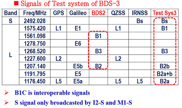
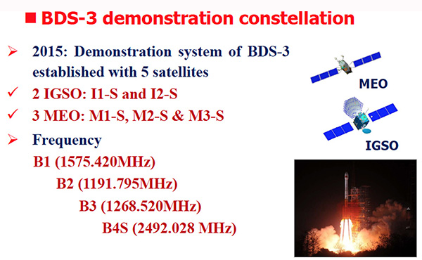
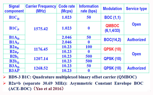
According to another source, the signals are mentioned in some publications (Figure 3, 4 and 5 from an official Chinese government presentation at the International GNSS Service Workshop, Oct. 2018) and intended to be open signals, but an ICD is presently missing. However there appears to be some clarity now, that the modulation of B2a+b is an “ACE-BOC” modulation, which is similar to but formally different from “AltBOC.”
Figure 3. BDS-3 demonstration constellation. (Chart: Javad GNSS)Figure 4. Signals of test system BDS-3. (Chart: Javad GNSS)Figure 5. BDS-3 signal modulations. (Chart: Javad GNSS)
Iridium Satellite Communications Inc. filed comments to the U.S. Federal Communications Commission (FCC) on Oct. 29 regarding outdated Ancillary Terrestrial Component (ATC) rules.
The company, operator of the Iridium satellite constellation — 66 low-Earth orbit satellites used for global voice and data communication from handheld satellite phones and other transceiver units — called for the rules to be removed by the FCC and replaced by new rules that better serve the spectrum ecosystem.
“Fifteen years ago, the FCC had a vision of satellite companies integrating terrestrial service into their core satellite business as a supplemental service. This vision has been never been successfully achieved — not once,” said Iridium spokesperson Jordan Hassin. “Instead, the result has been a constant whittling away at the rules to the point they have become irrelevant with a whole lot of collateral damage along the way. Given this history, it is appropriate for the FCC to consider the elimination of these outdated ATC rules while taking into account the realities of existing services and users.”
“ATC is an outdated concept that never developed as intended,” Rob McDowell, former commissioner of the FCC added.
The rules have resulted in proposals to get around them, such as Ligado, and significant fights over harmful spectrum interference to incumbent satellite systems. Ligado has sought to waive three gating criteria established by the FCC.
The Federal Aviation Administration’s (FAA) nationwide deployment of the Low Altitude Authorization and Notification Capability (LAANC) has exceeded all of the program’s original objectives.
Since the program began with a prototype system in November 2017, LAANC has processed more than 50,000 applications from drone operators for authorization to fly in controlled airspace. The system now covers almost 300 air traffic facilities serving approximately 500 airports, providing near-instantaneous approvals and allowing operators to quickly plan their flights. View a list of the participating facilities.
LAANC helps support the safe integration of drones into the nation’s airspace. The system uses airspace data provided through temporary flight restrictions, Notices to Airmen (NOTAMs) and unmanned aircraft system (UAS) facility maps that show the maximum altitude ceiling around airports where the FAA may authorize operations under Part 107, the small drone rule for commercial and public agency operators.
LAANC Service Suppliers
The FAA has approved 14 LAANC service suppliers. Instructions on how to apply are provided by each supplier:
Drone operators also can file for airspace authorizations using the FAA DroneZone, including for areas not covered by LAANC or when the operator holds a Part 107 waiver.
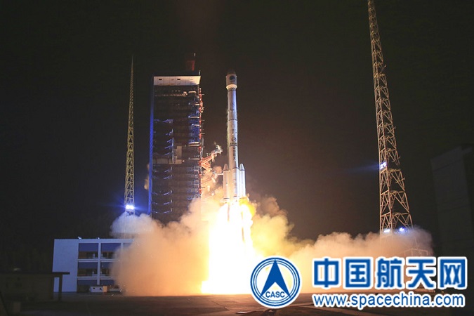
The launch and deployment of the 42nd and 43rd BeiDou satellites complete the basic BDS-3 constellation.
China has successfully sent twin BeiDou satellites into space by a Long March-3B launch vehicle (with an Expedition-1 upper stage) from the Xichang Satellite Launch Center, at 02:07 am, on Nov. 19. The twins, both medium Earth orbit (MEO) satellites, are the 42nd and 43rd of the BeiDou Navigation Satellite System (BDS), and the 18th and 19th of the BeiDou-3 family.
Photo: CASC screenshot
The satellites successfully entered their designated orbit after more than three hours of the launch, and will join the constellation with the 17 previously launched BDS-3 satellites, after completing in-orbit test.
The successful launch marks that the basic BDS-3 constellation has successfully been deployed. Networking of the constellation and assessment on its performances will be carried out in the near future.
Plans are for the BeiDou-3 constellation to be put into operation before the end of this year, to provide basic navigation services to countries and regions participating the Belt and Road initiative, which will be a key milestone for BDS in expanding service areas from regional to global.
The BDS-3 project was officially launched in 2009 with state approval, and a demonstration system was completed in 2016. Having verified the new-generation navigation signal system architecture, the BDS-3 development followed up with a three-step pattern, to construct its pilot, basic and nominal constellations respectively, according to the China Satellite Navigation Office,
On Nov. 5, 2017, the first pair of satellites for the BDS-3 constellation was launched from Xichang Satellite Launch Center. By the end of March 2018, a pilot constellation consisting of 8 BeiDou satellites was built.
At present, the project is progressing smoothly, and the basic constellation consisting of 19 BDS satellites will soon be operational. In the future, BDS with global coverage will be completed by the end of 2020.
Since November 2017, the past year has witnessed a highly intensive launch of the China’s BDS constellation. With the joint efforts of the whole team participating in this project, 11 launches have been completed within one year, while 19 BDS-3 satellites and 1 BDS-2 satellite have been successfully sent into space.
In particular, since July 2018, seven launches have been conducted to deliver 12 BDS satellites into orbit, with the shortest interval between launches being only 17 days. Both highly intensive and high success rate of launches set a new record in the history of the BDS constellation development.
The satellites and the launch vehicle (with an Expedition-upper stage) for this mission were developed by the China Academy of Space Technology and the China Academy of Launch Vehicle Technology respectively, both are affiliated to the China Aerospace Science and Technology Co., Ltd. The launch was the 291st mission of the Long March rocket series.
Currently, the BeiDou system comprises two families of operational navigation satellites; BeiDou-2, also known as Compass, presently consists of 15 operational satellites in Geostationary Orbit (GEO), Geosynchronous Orbit (GSO), Inclined Geosynchronous Orbit (IGSO) and Medium Earth Orbit (MEO).
The new BeiDou-3 series, on the other hand, only has operational MEO satellites at the moment, although China is testing the first BeiDou-3 GEO satellite (BeiDou-3G1) and plans to launch at least four GEO and GSO satellites in 2019.
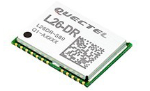
The module was introduced at the Electronica 2018 show, held Nov. 13-16 in Munich, Germany.
As the latest addition to Quectel’s GNSS portfolio, L26-DR is a concurrent multi-GNSS receiver module embedded with dead-reckoning solution, which greatly improves the positioning accuracy and speed while simplifying customer designs, the company said.
The dead-reckoning capability ensures the module delivers the highest performance positioning solution available, even when GNSS signal is absent or compromised, the company said.
Equipped with six-axis sensor MEMs and a powerful GNSS core, the module provides high sensitivity, fast GNSS signal acquisition and tracking with low system integration effort.
Moreover, the built-in low-noise amplifier offers the module with improved RF sensitivity and exceptional acquisition and tracking performances even in weak signal areas.
L26-DR is able to acquire and track any mix of GPS, GLONASS, BeiDou, Galileo and QZSS signals, which allows accurate navigation in harsh environments such as urban canyons, the company added. Compared with using GPS only, enabling multiple GNSS systems generally increases the number of visible satellites, reduces the time to first fix and improves positioning accuracy, especially when driving in rough urban environments.
Designed for automotive and industrial applications, the L26-DR comes in an ultra-compact size of 12.2 × 16.0 × 2.3 millimeters. The compact GNSS module also supports other precise positioning technologies, including differential GPS (RTCM) and SBAS (WAAS/EGNOS/MSAS/GAGAN).
According to the company, engineering samples of Quectel L26-DR will be available in December.