Telit has introduced a new positioning module aimed at India. The SL869T3-I combines GPS with India’s NavIC (IRNSS) navigation system and the country’s satellite-based augmentation system (SBAS), known as GAGAN.
The SL869T3-I module enables the creation of high-performance position reporting and navigation solutions. It complies with Automotive Industry Standard 140 (AIS-140) — an Indian government mandate that requires the use of NavIC for vehicle location tracking devices in all public transportation vehicles, effective April 2019.
The SL869T3-I is a 16 x 12.2-millimeter module with an LLC package. It is provided with a single RF input for L1 and L5 bands. It also contains Flash memory, a low noise amplifier (LNA) and SAW filters. The RF front end is specifically designed to comply with sensitivity specifications contained in AIS-140 standard.
“The new SL869T3-I is among the first IoT GNSS positioning receiver modules to deliver IRNSS/NavIC L5 coverage compliant with the Indian government’s AIS-140 regulation,” said Manish Watwani, EVP global product management, Telit. “This new addition to the Telit family of products results from more than 20 years’ experience in GNSS applications.”
For more information, visit booth C3.227 at Electronica, Nov. 13-16 in Munich, Germany.
The U.S. Federal Communications Commission (FCC) granted in part the European Commission’s request for a waiver of the commission’s rules so that non-federal devices in the United States may access specific Galileo signals. While private users were free to use the European GNSS, with this ruling entities such as telecommunications companies can now also use Galileo.
With today’s action, consumers and industry in the United States will now be permitted to access the E1 and E5 Galileo signals to augment GPS.
Since the debut of the first consumer handheld GPS device in 1989, consumers and industry in the United States have relied on the U.S. GPS to support satellite-based positioning, navigation, and timing (PNT) services that are integral to everyday applications ranging from driving directions to precision farming.
The order, approved Nov. 15, finds that Galileo is uniquely situated as a foreign GNSS system with respect to the U.S. GPS, since the two systems are interoperable and radiofrequency compatible pursuant to the 2004 European Union/United States Galileo-GPS Agreement.
Specifically, the order permits access to two of the Galileo system’s satellite signals — the E1 signal that is transmitted in the 1559-1591 MHz portion of the 1559-1610 MHz Radionavigation-Satellite Service (RNSS) frequency band, and the E5 signal that is transmitted in the 1164-1219 MHz portion of the 1164-1215 MHz and 1215-1240 MHz RNSS bands. These are the same RNSS bands in which the U.S. GPS satellite signals operate.
The order does not grant access to the Galileo E6 signal, which is transmitted over the 1260-1300 MHz frequency band, since this band is not allocated for RNSS in the United States or used by the U.S. GPS to provide PNT services.
The commission noted that granting access to the Galileo E6 signal could constrain U.S. spectrum management in the future in spectrum above 1300 MHz, where potential allocation changes are under consideration.
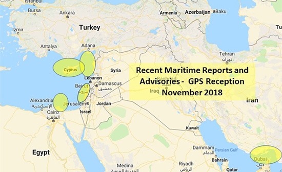
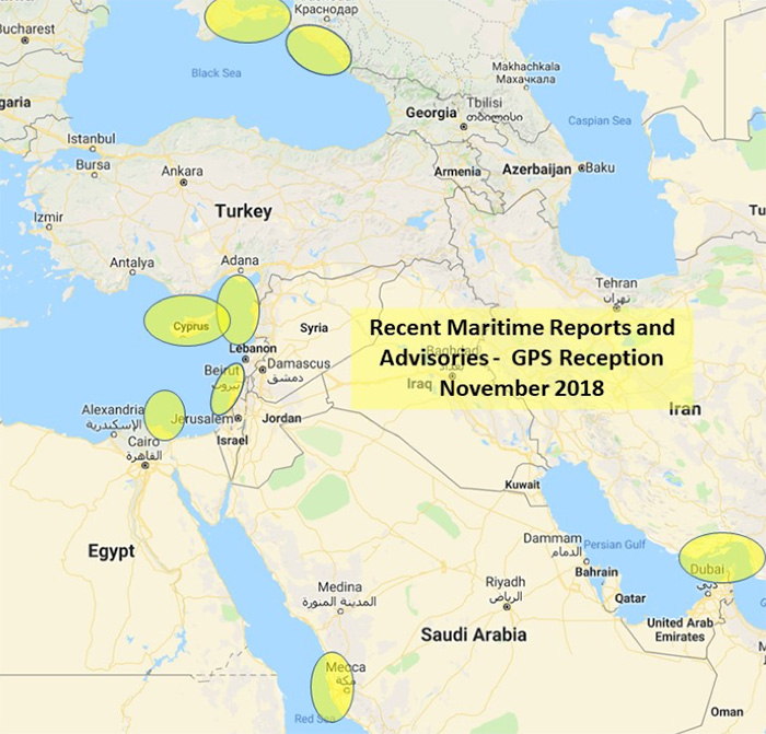
The U.S. Maritime Administration issued an expanded advisory for GPS disruptions in the Middle East. The new advisory renews and repeats warnings for the eastern Mediterranean and adds the Port of Jeddah in Saudi Arabia.
Reports have also been filed with the U..S Coast Guard Navigation Center about disruptions in Israel’s Port of Haifa and the Straits of Hormuz.
Analysis by the Resilient Navigation and Timing Foundation and the non-profit firm C4ADS has also shown on-going disruptions in Russian waters of the Black Sea. Also, GPS jamming by Russia is suspected during a recent NATO exercise.
The armed conflict in Syria has been blamed for much of the disruptions off of its shores.
GPS jamming in support of illegal fishing is suspected by some as the cause of problems off of Port Said, and disputes over mineral rights has been suggested for the disruptions seen near Cyprus.
Disruptions in the Black Sea are suspected to be security measures associated with the travel of Russian government officials.
Map: U.S. Maritime Administration Advisory 2018-014-GPS
Text of Maritime Administration Advisory
2018-014-GPS Interference-Eastern Mediterranean and Red Sea
This revised advisory cancels U.S. Maritime Advisory 2018-007.
Reference: U.S. Maritime Alerts 2018-004A, 2018-004B, 2018-008A.
Issue: Multiple instances of significant GPS interference continue to be reported by vessels and aircraft operating in the Eastern Mediterranean Sea. These reports have been concentrated near Port Said, Egypt, the Suez Canal, and in the vicinity of the Republic of Cyprus. Additional instances of similar interference were reported in October 2018 near Jeddah Port, Saudi Arabia. This interference is resulting in lost or otherwise altered GPS signals affecting bridge navigation, GPS-based timing and communications equipment.
Guidance: Exercise caution when transiting these areas. The U.S. Coast Guard Navigation Center (NAVCEN) and NATO Shipping Center websites contain information regarding effective navigation practices for vessels experiencing GPS interference. The information reaffirms safe navigation practices when experiencing possible GPS disruption, provides useful details on reporting possible GPS disruption, and is intended to generate further discussions within the maritime community about other disruption mitigation practices and procedures. This guidance also recommends taking note of critical information such as the location (latitude/longitude), date/time, and duration of the outage/disruption, and providing photographs or screen shots of equipment failures during a disruption to facilitate analysis. The NAVCEN information is available at https://go.usa.gov/xQBaU.
Contact Information: GPS disruptions or anomalies should be immediately reported to the NAVCEN at https://go.usa.gov/xQBaw or via phone at 703-313-5900, 24 hours a day. The NATO Shipping Center has requested that instances of GPS interference also be reported to them using the format on their Cyber Interference link.
Cancellation: This message will automatically expire on May 2, 2019.
The Notilo Plus team with the iBubble. (Photo: Notilo Plus)
Notilo Plus has launched iBubble, a fully wireless, autonomous and intelligent underwater drone. iBubble can accompany divers for up to an hour and down to 197 feet depth, acting as their personal cameraman and enabling superior underwater imaging.
Founded in 2016, Notilo Plus is a Marseille, France-based start-up created to develop intelligent underwater exploration technologies.
The remotely operated vehicle (ROV) was designed using Notilo Plus’ patented underwater localization technology, enabling subaquatic adventures without tethers. It comes with an advanced artificial intelligence system, offering total autonomy and self-learning capabilities.
The localization technology is mainly based on acoustic signal transmission and image recognition (video tracking). By combining these technologies, iBubble is able to locate precisely its target underwater and thus shoot perfectly stable footage.
iBubble is equipped with an obstacle avoidance system, which allows it to smoothly follow a diver, while obtaining images of unparalleled quality for personal or commercial use, the company said. It features real-time image recognition, a stabilization system and direct surface control, bringing outstanding performance to underwater imaging.
The iBubble ROV is an environmentally conscious device — it does not disturb the fragile marine ecosystem thanks to its minimal noise emission levels and its obstacle-avoidance capability.
iBubble can be used for sports and entertainment filming, diving instruction, wildlife protection, search-and-rescue operations, naval or underwater infrastructure maintenance, and subsea patrolling.
“We are excited to introduce to the world the first fully wireless, autonomous underwater drone,” said Nicolas Gambini, CEO of Notilo Plus. “With the countless cutting-edge technologies brought by the iBubble, coupled with its ability to bring exceptional pictures and video footage, this is a remarkable and versatile device for any diving activity.”
The device is now available for order globally. The first batches of iBubble drones will be delivered to the customers, including the Indiegogo crowdfunding campaign supporters, from mid-November 2018.
Drone surveying software Virtual Surveyor now eliminates the need for clients to use third-party applications to prepare data for processing. Released this week, Virtual Surveyor 6.1 now handles on-the-fly projections that previously required a separate software package to set the data in the proper coordinate system.
“We have developed a completely new project experience for users of UAV data,” said Tom Op ‘t Eyndt, managing director of Virtual Surveyor in Belgium. “Version 6.1 will save our customers time and money once spent converting their drone data for processing in Virtual Surveyor.”
Virtual Surveyor bridges the gap between UAV photogrammetric processing applications and engineering computer-aided design (CAD) packages. The software generates an interactive onscreen environment with UAV orthophotos and digital surface models where the surveyor selects survey points and breaklines to define the topography, creating highly accurate topographic products for CAD input up to five times faster than otherwise possible.
“Our value proposition has always been to enable surveyors to derive topographic information from drone data and deliver the light-weight meaningful CAD model that engineers need,” said Op ‘t Eyndt.
Prior to Version 6.1, users always had to start from an orthophoto and digital surface model (DSM). Now, surveyors can drag and drop all kinds of files into Virtual Surveyor: points, raster, vectors and point clouds. The point clouds are converted to a DSM for manipulation and processing, dramatically accelerating the time required to generate the CAD model.
“Not only is this faster, but it eliminates the expense of purchasing additional software,” said Op ‘t Eyndt.
Some customers asked to work only with a CAD file, he explained. Although they work with drone data most of the time, they occasionally had to create a surface or contours from a traditional survey. They asked if this could be done in Virtual Surveyor as it would save them from paying for a subscription to a CAD software.
Long-time Virtual Surveyor clients will find the entire project experience has been streamlined and improved with new capabilities in V6.1:
Start from any data set. Projects can now be initiated from Orthophotos, DSMs, Point Cloud or CAD files.
Convert coordinates on the fly. Users can input data in any coordinate system and convert it during processing to another system after the project has begun.
Developers of Virtual Surveyor have also added these features to V6.1:
Automatic creation of section lines. V6.1 automatically generates sections from road surfaces to survey transportation routes in minutes.
Transparent layers. Users can add topographic or cadastral data to their project and view it through the orthophoto layer to annotate or draw boundaries.
“Overall, users will experience a faster processing environment in Virtual Surveyor 6.1 especially during complex tasks, such as making terrain modifications or calculating volumes,” said Op ‘t Eyndt. “Our goal with this version has been to make professional land surveyors more efficient.”
Current subscribers to Virtual Surveyor will see their software being updated automatically.
When a Pennsylvania county’s 911 system suddenly went down without warning, garbled messages across the network impacted fire and police agencies’ ability to respond to emergency messages. The issue was traced to a firmware malfunction on communications equipment, related to provision of GPS timing. The firmware had not been updated for 19-1/2 years. Why should it have been? Everything was working fine — until it didn’t.
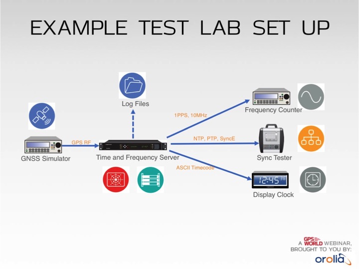
Test lab set-up. Photo: Orolia
In addition to increased jamming and spoofing threats, GPS has a “week rollover event” set to happen in April 2019. If the GPS receivers found at the heart of many critical systems do not handle this properly, any number of failures can occur.
Without GPS timing, everything slows down, has less capacity and becomes more dangerous.
This Thursday, a complimentary webinar outlines test plans for GNSS equipment used in critical timing applications, discusses the need for assured access to accurate timing across financial institutions, industrial automation, telecommunications, transportation, the power grid and elsewhere — and defines just what “assured” access means and how crucial the “assured” part is — and finally reviews some recent mishaps and near-disasters caused by interrupted or inaccurate timing.
Speaking on the 1-hour webinar are Lisa Perdue, product manager and applications engineer, Orolia; Stefania Römisch, leader, the Atomic Standards Group at the National Institute of Standards and Technology; and Dana Goward, president, Resilient Navigation and Timing Foundation.
Following each speaker’s 12- to 15-minute slide presentation, a live Q&A period with the audience will explore particular issues and concerns.
Bentley Systems has entered an agreement to acquire Quebec City-based AIworx, provider of machine learning and internet of things (IoT) technologies and services.
Bentley Systems is the leading global provider of software solutions to engineers, architects, geospatial professionals, constructors, and owner-operators for the design, construction, and operations of infrastructure.
The addition of AIworx brings advancements in data collection and analysis to leverage infrastructure engineering digital twins, continuously updated with real-time contextual information, to optimize productivity, operations and maintenance, Bentley Systems said.
Bentley Systems also announced the acquisition of ACE enterprise Slovakia, provider of innovative technology solutions to interface with enterprise resource planning (ERP), enterprise asset management (EAM), and geographical information systems. ACE enterprise has been a technology partner of Bentley Systems, and the ACE Enterprise Platform is used for the Bentley AssetWise connector that is certified for both SAP ERP and SAP HANA.
AIworx machine learning and IoT technologies leverage digital twins’ analytics visibility for infrastructure asset performance. (Image: Bentley Systems)
“AIworx has been providing machine learning and IoT technologies and services to help organizations generate, understand, and act on data so they can make better business decisions,” said Andre Villemaire, co-founder and president of AIworx.
“The biggest opportunities we’ve worked on have to do with improving infrastructure asset performance on an industrial scale, by way of the data from connected machines, instrumentation, sensors, and communications systems — and we’re excited to dedicate ourselves to that advancement,” Villemaire continued. “Now, by incorporating our tools into Bentley’s services for digital twins, we enable infrastructure operators to multiply the potential benefits of machine learning and IoT.”
“Machine learning and IoT technologies have created the opportunity for profound improvements in productivity and efficiency of infrastructure,” said Francois Valois, vice president of portfolio development for Bentley Systems. “Our new colleagues from AIworx have already been delivering on this potential, and now, leveraging the analytics visibility, which Bentley’s digital twin cloud services uniquely provide, these advancements from going digital will accelerate exponentially.”
Alexander Cimbalak, founder of ACE enterprise, said, “We have enjoyed our partnership with Bentley to provide enterprise connectors and are very excited to be part of Bentley and also now to enable Bentley’s digital twin cloud services to uniquely synchronize with infrastructure assets’ enterprise IT, OT, and ET data sources.”
Alan Kiraly, senior vice president, asset performance for Bentley Systems, said, “ACE enterprise has consistently overcome IT interoperability challenges for us at Bentley. Now, as colleagues, this talented team will enable us to continue to expand the scope and breadth of information that can be accessed through AssetWise and digitally aligned within infrastructure digital twins.”
NextNav’s Metropolitan Beacon System (MBS) service has been accepted for use by NASA. NASA will use NextNav’s MBS network as part of its CERTAIN (City Environment for Range Testing of Autonomous Integrated Navigation) facilities at NASA’s Langley Research Center in Hampton, Virginia.
CERTAIN supports, among other programs, Urban Air Mobility (UAM), an air transportation system with myriad applications from small package delivery drones to passenger-carrying air taxis.
The Federal Aviation Administration (FAA) believes that by 2022 there will be more than 700,000 drones delivering packages, monitoring traffic and aiding in search and rescue operations. NASA’s role is to provide research findings to reduce technical barriers associated with integrating unmanned aircraft systems into the national airspace system.
NextNav’s MBS system facilitates urban drone operations where satellite-based GPS signals may not be available. The need to reliably know a drone’s location horizontally and vertically is critical to ensure safe operations in urban air traffic corridors.
Uber in the Mix. Uber and Bell (formerly Bell Helicopter) plan to launch an on-demand mobility venture, or flying taxis, nationwide by 2023, so the need to precisely track vehicles moving throughout city airspace is imminent.
The move to such flying taxis would require a change to current FAA-controlled airspace separation requirements, according to Tom Prevot, Uber’s director of airspace systems. He stated that the Uber venture foresees takeoffs and landings from city vertiports every 24 seconds, requiring a considerable reduction in the minimum-distance standards of 1,000 feet vertically or 3 to 5 nm horizontally, as currently mandated in FAA order JO 7110.65.
Metro Beacons. “NextNav’s MBS system provides us with new tools for the development of navigation systems in environments where GPS has traditionally been challenged,” said Evan Dill, Safety-Critical Avionics Systems Branch of NASA. “We’re looking forward to working with MBS as we develop new approaches to the operation of unmanned systems in urban environments.”
NextNav’s wide-area terrestrial positioning network provides accurate and secure location services, critical for unmanned aircraft navigation. In addition, MBS complements and integrates seamlessly with GPS and provides a level of geo-redundancy ensuring a safe and efficient system for future air transportation in cities and urban areas, with particularly difficult challenges at low altitudes where solutions such as radar, GPS and ADS-B are unreliable or insufficient.
Delivered over a managed network on nationwide licensed spectrum with carrier-grade dependability and metropolitan-wide coverage, NextNav said its services are designed for public safety applications, E911, critical infrastructure, as well consumer, Internet of Things (IoT) and commercial applications that require reliable 3D geolocation indoors and urban areas or precise timing.
Future city airspace filled with drones and passenger aircraft. (Image: NASA)
“We are proud to work with NASA and integrate MBS into its urban drone operations,” said Ganesh Pattabiraman, co-founder and CEO of NextNav. “The MBS system is designed for secure, reliable and consistent 3D geolocation capabilities, which are important for autonomous systems such as drones. NASA’s acquisition of the MBS system is an exciting milestone for MBS technology and a great partnership with NASA to address the key challenges in urban drone navigation and make it possible to explore new opportunities in unmanned operations.”
Update: The Camp Fire is now the deadliest fire in California history, claiming more than 50 lives.
DigitalGlobe’s WorldView-3 satellite collected new imagery of the deadly Camp Fire near Paradise, California.
The Camp Fire, which broke out Nov. 8, destroyed 90 percent of the town of Paradise. At least 29 people have died, making it the deadliest wildfire in the state’s history in more than 85 years, while more than 200 people are unaccounted for. Firefighters are still trying to contain the roaring blaze.
Here is a link to download a set of satellite images as well as a map graphic (PDF file). The satellite images include a couple of different views of the fire including:
A natural color overview of the area. The smoke from the wildfire obscures much of the area around Paradise and the surrounding communities.
Shortwave Infrared (SWIR) images of the area. SWIR images from our satellite can penetrate smoke caused by the fire and help clearly identify the fire lines and areas that have burned/are burning.
A rotated SWIR view of the fires, in case the orientation would be more useful for your graphic teams.
A reference image/map graphic (see PDF file) that should help you correlate the images to the locations on the ground.
NATO conducted its largest military exercise since the Cold War in the frigid waters and icy mountains of Norway Oct. 25-Nov. 7.
During the final days of the Trident Juncture exercise, GPS signals guiding ships, aircraft, tanks, trucks and troops began to fail. Tracking screens flickered and positions were suddenly wrong from a few meters to hundreds of kilometers.
Civilian airliners, cars, trucks, cargo ships and smartphones operating in and around Norway and Finland experienced similar disruptions. Norway-based airline Wideroe told The Barents Observer that its pilots were reporting the loss of GPS signals when flying to airports in northern Norway and Finland. Airfields affected ranged from Kirkenes, on Norway’s border with Russia, to Lyngen in Troms, much further west.
Russia is the chief suspect of jamming the signals in reaction to the massive size and proximity of the military exercises. Russia also has recently conducted massive military exercises in the Baltics.
“It is possible that Russia has been the disrupting party in this,” Finland’s Prime Minster Juha Sipila told local media. “Russia is known to possess such capabilities.”
Trident Juncture involved all 29 NATO alliance members. Neutral Sweden and Finland also took part amid growing uncertainty over Russia’s ambitions in the tense region.
The United Nations’ International Committee on GNSS (ICG) held its 13th meeting in Xi’an, China, Nov. 4-9. Attendees included the four major GNSS: GPS (United States), GLONASS (Russia), BeiDou (China) and Galileo (Europe). Also attending were representatives from Japan, India and delegates from 16 countries and regions.
Members called for further strengthening of the interoperability and transparency of GNSS to help more countries enjoy the developments in positioning, navigation and timing, according to China Global Television Network.
On Nov. 7, China and Russia signed a cooperation agreement for BeiDou and GLONASS, stressing that the two systems begin testing service aims for countries along China’s Belt and Road.
More than 400 delegates across the world also watched the demonstration of applications based on China’s BeiDou system, which includes drones and vehicle positioning technology that could be used by self-driving cars.
The positioning system was tested on a bus with accuracy reaching millimeters, as shown in a video on this page. This technology lays the foundation for the management of urban traffic.
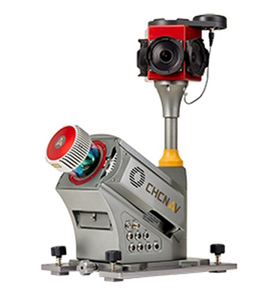
CHC Navigation has launched the Alpha3D Mobile Mapping solution, which provides a unique combination of sensor technologies and the company’s core GNSS expertise.
The Alpha3D is a high-performance, vehicle-independent mobile mapping solution that can capture mass data in continuously changing world environments, enabling geospatial professionals to get work done quickly and more accurately to increase their return on investment.
The Alpha3D can be mounted on a variety of platforms, including different type of vehicles, trains, railway trolleys and boats. It rapidly and efficiently collects high density, accurate point clouds and powerful image data. It also adds extra information from additional sensors, such as a high-resolution camera, thermal camera, echo sounder or extra profiler.
The Alpha3D combines high-performance hardware — including a long range, ultra-high speed, precise laser scanner, high-resolution HDR panoramic camera in combination with an advanced GNSS receiver and high-precision inertial measurement unit (IMU) — in one instrument in a light weight, compact yet rugged design, according to George Zhao, CEO of CHC Navigation.
“All theses features keep Alpha3D as one of most innovative system in market today,” Zhao said.
“With Alpha3D, users can collect more data faster and reduce time in the field more than 40% compared to traditional surveying instruments,” said Andrei Gobb, product manager of Mobile Mapping Solutions. “By combination of point clouds and high-resolution images, as well as information from additional sensors, there is no need to return to site for remeasurement.”