Author: GPS World Staff

  • Unicore introduces GNSS/INS high-precision board, CLAP-B

    Unicore introduces GNSS/INS high-precision board, CLAP-B

    Photo: Unicore
    Photo: Unicore

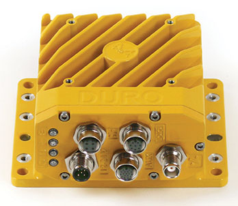
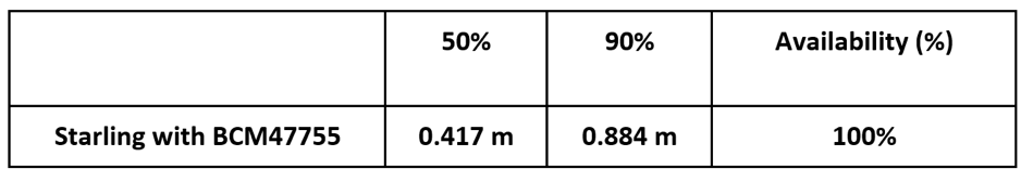
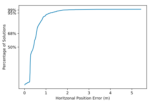
    Unicore Communications has launched CLAP-B, a multi-GNSS/MEMS integrated inertial navigation board, which integrates a miniaturized high-performance inertial measurement unit (IMU) on a compact high performance GNSS board.

    The high-accuracy GNSS positioning coupled with a high-precision gyro and accelerometer provides stable, continuous three-dimensional position, velocity and attitude, as well as original acceleration and angular velocity measurements, even in GNSS-denied environments, the company said.

    CLAP (Concurrent Localization & Attitude Pilot) technology is a high-precision multi-sensor fusion positioning and orientation technology developed by Unicore.

    The CLAP- B, along with all the UM and UB family of receivers, are on display at BDStar booth C12.0C.022 for the duration of Intergeo 2018 starting Oct. 16 in Frankfurt, Germany.

    Key features of the CLAP-B include:

    • Compact size: 46 × 71 × 17.1 mm
    • 5-ns RMS PPS output
    • 0.1 degree (1σ) pitch and roll
    • WINS optimized technology (wheel INS) for vehicles, wheeled robotics
    • Integrated INS/GNSS/odometer
    • 100-Hz positioning output/original IMU measurement output
    • Support for BDS B1 / B2 + GPS L1 / L2 + GLONASS L1 / L2 + Galileo E1 / E5b + QZSS L1/L2
    • Supports dual-antenna or single antenna
    • 3.3 ~ 5 VDC input

    With the features of compact size, light weight, low power consumption, and easy for integration and mass production, CLAP-B is suitable for applications such as autonomous driving, smart surveying, unmanned aerial vehicles and various attitude stabilization platforms. Customer samples will be available by the first quarter of 2019.

  • Live from Intergeo 2018

    Logo: IntergeoThe GPS World staff is reporting from Intergeo Oct. 16-18 in Frankfurt, Germany. The massive trade show, dubbed the “global hub of the geospatial community,” brings together more than 17,000 visitors from more than 107 countries and features approximately 640 exhibitors. Check out the latest industry news, as well as photos and videos from the event.

    Videos

    Choose the video you’d like to watch by clicking the icon in the top left hand corner of the video screen.

    News

  • Swift Navigation and Carnegie Robotics introduce Duro Inertial

    Swift Navigation and Carnegie Robotics introduce Duro Inertial

    Duro Inertial fuses GNSS and inertial measurements into a combined solution. (Photo: Swift Navigation)
    Duro Inertial fuses GNSS and inertial measurements into a combined solution. (Photo: Swift Navigation)

    Swift Navigation and Carnegie Robotics LLC (CRL) have released their second joint product, Duro Inertial.

    Duro Inertial is a ruggedized version of Swift Navigation’s Piksi Multi dual-frequency real-time kinematic (RTK) GNSS receiver combined with CRL’s SmoothPose sensor fusion algorithm, which fuses GNSS and inertial measurements into a combined solution.

    The blending of GNSS and inertial measurements provides a dead-reckoning capability that allows Duro Inertial to provide a highly accurate, continuous position solution during brief GNSS outages and to deliver a robust precision navigation solution in harsh GNSS environments.

    Duro Inertial is an evolution of Swift and CRL’s first joint product, Duro. Building on the on-board MEMS inertial measurement unit (IMU) that exists in Duro today, Duro Inertial harnesses CRL’s loosely coupled (LC) sensor fusion algorithm, SmoothPose, to blend GNSS and inertial inputs, providing a smoother, more available and more robust position, velocity and time (PVT) solution, the companies said.


    Duro Inertial seamlessly blends CRL’s SmoothPose GNSS+INS algorithms with Swift Navigation’s Starling Positioning Engine to deliver a highly-accurate LC positioning solution even in GNSS / RTK denied environments.

    The inertial aiding feature can operate with RTK, autonomous GNSS and satellite-based augmentation system (SBAS) position solutions from Starling. Duro Inertial also inherits the full set of features from Duro and Piksi Multi including the light-weight SBP communication protocol, interoperability with legacy protocols such as NMEA output and RTCMv3 input, compatibility with RTK corrections services such as Skylark, Swift’s Cloud Correction Service and many third-party corrections services, and quad-constellation dual-frequency RTK navigation.

    The combination of Duro Inertial’s positioning accuracy and its ruggedized enclosure that protects against weather, moisture, vibration, dust and water immersion makes it suitable for construction, mining, logistics, positive train control, robotics and agriculture applications.

    “We are excited to introduce our second collaboration with Carnegie Robotics and build on the success of the Duro ruggedized receiver launched last year,” said Timothy Harris, co-founder and CEO of Swift Navigation. “The combination of Carnegie Robotics’ advanced inertial technology and robotics expertise with Swift’s positioning solution will enable an even broader customer segment to benefit from highly-accurate positioning.”

    “Duro Inertial is the culmination of our partnership with Swift over the past two years,” added John Bares, CEO of Carnegie Robotics. “Working together we are able to deliver a consistent and highly-accurate positioning solution to benefit a variety of robotics and industrial applications.”

    Duro Inertial is scheduled to be available at for purchase in the fourth quarter and is now available for select customer testing.

  • Garmin’s latest watch features GPS, GLONASS and Galileo

    Garmin’s latest watch features GPS, GLONASS and Galileo

    Garmin is now offering a GPS, GLONASS and Galileo watch called Instinct. Instinct is a strong and durable watch with GNSS support, plus built-in 3-axis compass, barometric altimeter and wrist-based heart rate sensor.

    The watch includes a built-in sports apps, smart connectivity and wellness data.

    Photo: Garmin
    Photo: Garmin

    “We are thrilled to add Instinct to our adventure watch lineup, an approachable smartwatch that is rugged and reliable,” said Dan Bartel, Garmin vice president of global consumer sales. “Instinct is perfect for those who spend their time outdoors and demand a device built tough to stand up in the elements.”

    The Instinct is built to endure challenging environments, constructed to military standards (MIL-STD-810G) for thermal, shock and water resistance (rated to 100 meters) with a fiber reinforced polymer case. The chemically strengthened and scratch-resistant display is readable in direct sunlight, and the fully vented silicone bands include two independent, removable keeper loops to ensure a secure fit.

    The multi-GNSS feature helps users track their location in challenging environments. The Garmin Explore app helps plan the trip in advance, and the TracBack feature can navigate the same route back to the starting point.

    The built-in heart-rate sensor helps monitor heart rate, steps taken, distance traveled, calories burned and more.


  • NCTech to unveil iSTAR Pulsar developments at Intergeo 2018

    NCTech, a developer of reality imaging systems, will showcase its iSTAR Pulsar mobile 360-degree data capture system at Intergeo in Frankfurt, Germany.

    Companies at Intergeo, including GeoSLAM and Orbit Geospatial Technologies, will also unveil innovative developments that incorporate iSTAR Pulsar.

    iSTAR Pulsar is NCTech’s professional edge-to-cloud big data system, optimized for capture on the move. iSTAR Pulsar is designed to capture 360-degree data while mounted on a vehicle, drone or on foot.

    At Intergeo, NCTech will be showing a demonstration of a future feature in its cloud-based processing software VR.WORLD that uses artificial intelligence and image recognition to analyze the images captured by iSTAR Pulsar. This means that objects like cars, trucks, traffic lights, road signs, pedestrians and cyclists can be automatically identified in images, the company said.

    Handheld 3D mobile mapping company GeoSLAM also will introduce new developments at Intergeo, including an innovation that integrates with iSTAR Pulsar.

    “We immediately saw the potential for collaboration when NCTech introduced the iSTAR Pulsar,” said Mark Reid, head of strategic business development, GeoSLAM. “And now we’re excited to show the attendees at Intergeo what we’ve been working on.”

    Orbit GT has updated its mobile mapping software to enable iSTAR Pulsar data to be integrated into its smart 3D mapping solutions.

    “We’re very pleased to announce that Orbit GT solutions now support data from NCTech’s iSTAR Pulsar,” said Peter Bonne, CEO, Orbit GT. “We’ll be showcasing the great 360-degree imagery captured by iSTAR Pulsar at our booth.”

    “We launched iSTAR Pulsar earlier this year, so it’s great to see that key industry players like GeoSLAM and Orbit GT are already leveraging its capabilities in their own developments,” said Andrew Baddeley, technical sales director, NCTech. “Combined with the exciting new AI developments from our labs, we look forward to showing everyone at Intergeo how we are helping to virtualize the world.”

  • SBG Systems offers GNSS+inertial navigation for surveying, UAVs

    SBG Systems offers GNSS+inertial navigation for surveying, UAVs

    SBG Systems is launching the Navsight Land & Air Solution, high-performance inertial navigation designed to make surveyors’ mobile data collection easier, whether for mobile mapping, GIS or road inspection.

    SBG Systems will release the Navsight Land & Air Solution at the Intergeo show in Frankfurt, Germany, Oct. 16-18.

    The solution consists of an inertial measurement unit (IMU), available at two different performance levels, connected to Navsight, a rugged processing unit embedding fusion intelligence and a GNSS receiver. It also has connections for external equipment such as lidar, cameras or computer.

    Photo: SBG Systems
    Photo: SBG Systems

    The Navsight Land & Air Solution is the result of more than 10 years of experience in the mobile positioning industry, especially in the unmanned industry where position reliability is mandatory. SBG’s fusion algorithms allow the company to get the best performance from inertial, odometer and GNSS technologies; exclude false GNSS fixes; and improve the trajectory in complicated areas such as urban canyons, forests and tunnels.

    According to the company, the Navsight Land & Air Solution supports all GNSS constellations, real-time kinematic (RTK) and precise point positioning services such as Omnistar and TerraStar.

    SBG IMUs are easy to install, the company said. The sensor alignment and lever arms are automatically estimated and validated. Once connected to the Navsight processing unit, the web interface guides the user to configure the solution. A 3D view of the vehicle shows the entered parameters so that the user can check the installation. By choosing the vehicle, such as a plane or a car, the inner algorithms are automatically adjusted to the application. The Navsight unit also integrates LED indicators for satellite availability, RTK corrections and power.

    INS/GNSS Post-Processing Software. Qinertia, the SBG post-processing software, provides access to offline RTK corrections from more than 7,000 base stations in 164 countries. Trajectory and orientation are greatly improved by processing inertial data and raw GNSS observables in forward and backward directions.


  • U.S. Army recognizes GeoDecisions for modernizing convoy mapping module

    Automated Movement and Identification Solutions (AMIS), a division of the U.S. Department of the Army, has bestowed a Certificate of Appreciation to GeoDecisions, Gannett Fleming’s geospatial technology division.

    The certificate recognizes GeoDecisions for its outstanding technical expertise and dedication in the modernization of the Transportation Coordinators’ – Automated Information for Movements System II (TC-AIMS II) Convoy Planning Highway Regulation (CPHR-M) module.

    TC-AIMS II CPHR-M is an advanced software solution used to plan the Army’s convoy movement around the globe. GeoDecisions integrated the Transportation Geospatial Information System (TGIS) map and routing tool through the TGIS application programming interface to embed the map within the TC-AIMS system.

    The TGIS integration with TC-AIMS provides enhanced, real-time mapping functions, faster processing speeds, and a more user-friendly experience.

    The recognition also honors the GeoDecisions team for its technical knowledge, attention to detail, and ability to recognize, understand and address issues quickly to allow CPHR-M to stay on schedule.

    The team’s efforts resulted in more than a dozen changes to the baseline to provide better performance and additional capabilities that were not identified at the start of the project.

    “It’s almost unheard of to receive an award like this from a government program, so we feel especially humbled by this honor,” said Brendan Wesdock, MCP, GISP, president of GeoDecisions. “We’ve built an exceptional team of geospatial professionals who continuously push the boundaries of geospatial technology to deliver the most effective and valuable solutions to our clients.”

    AMIS is the primary source of providing automated movement and identification solutions across the DOD and around the globe. AMIS is the essential supplier for Transportation Coordinators’ – Automated Information for Movements System II (TC-AIMS II) with approximately 5,000 active users.

    The GeoDecisions team (from left): Jay Ross, senior software test specialist; Jeff Carter, TGIS lead system administrator with sub-consultant Aegis Strategies, LLC; Steve Kraabel, senior client manager; Debra Houser, director of Application Development; Bret Huber, lead and software developer; (not pictured) Andrew Miller, developer. (Photo: GeoDecisions)
    The GeoDecisions team (from left): Jay Ross, senior software test specialist; Jeff Carter, TGIS lead system administrator with sub-consultant Aegis Strategies, LLC; Steve Kraabel, senior client manager; Debra Houser, director of Application Development; Bret Huber, lead and software developer; (not pictured) Andrew Miller, developer. (Photo: GeoDecisions)


  • Enhanced Stinger missile counters enemy UAVs

    Enhanced Stinger missile counters enemy UAVs

    U.S. Army completes qualification testing for new Stinger missile proximity fuze.

    The new proximity fuze enables the Stinger missile to destroy a wider array of battlefield threats such as enemy unmanned aircraft systems. (Photo: U.S. Army)
    The new proximity fuze enables the Stinger missile to destroy a wider array of battlefield threats such as enemy unmanned aircraft systems. (Photo: U.S. Army)

    The U.S. Army has completed qualification testing for a new proximity fuze that significantly enhances the combat-proven Stinger missile produced by Raytheon Company.

    The proximity fuze detonates the warhead if the missile passes within a certain radius of the target, creating a cloud of shrapnel that eliminates the target.

    During testing at Eglin Air Force Base in Florida in April 2017, the upgraded weapon system scored a perfect 100 percent hit rate against a variety of targets. The missiles were shoulder- and vehicle-launched.

    The new proximity fuze enables the lightweight, self-contained air defense system to destroy a wider array of battlefield threats such as enemy unmanned aircraft systems by detonating the missile’s warhead near the target, while maintaining its hit-to-kill capability.

    “Equipped with a new proximity fuze, Stinger is an affordable, near-term and proven solution for countering emerging threats in the battlespace,” said Kim Ernzen, Raytheon Land Warfare Systems vice president. “Together with the Army, we are putting the most capable Stinger yet into the hands of our brave men and women on the battlefield.”

    https://youtu.be/h75hxN-hcMQ

    With qualification testing complete, the Army can move toward a near-term fielding under an Urgent Materiel Release. Plans call for the new proximity fuze to be integrated into Stinger missiles as part of a Service Life Extension Program to be conducted at the Army’s ammunition plant in McAlester, Oklahoma.

    Combat proven, the Stinger missile has more than 270 fixed- and rotary-wing intercepts to its credit. It’s deployed in more than 18 nations and with all four U.S. military services. The weapon can be rapidly deployed by ground troops and on military platforms, and has been integrated for use on the Apache Attack Helicopter.

  • Hexagon Geospatial launches HxGN Smart Census

    Hexagon’s Geospatial division has launched its total population and housing census management and workflow solution, HxGN Smart Census.

    HxGN Smart Census makes each phase of the census process smarter and more manageable, the company said. HxGN Smart Census pricing is agile, taking into account a nation’s surface area, population, and Human Poverty Index to ensure that all countries can participate in the digitalizing of their census processes.

    Image: Hexagon
    Image: Hexagon

    HxGN Smart Census integrates traditional GIS functionality with a powerful workflow and workforce management tool to provide a total solution for census strategies: from pre-enumeration mapping, to digital enumeration, to post-enumeration dynamic mapping. It can be used on its own or integrated with a nation’s or organization’s existing GIS infrastructure.

    The solution was developed in consultation with South African GIS experts GeoSpace International, and has already been procured by South Africa and Botswana.

    “With HxGN Smart Census, the census gets completed much faster, and the mobile application has made things much simpler for the field workers who are conducting the interviews,” said Shonisani Maranda, senior GIS officer at Statistics South Africa. “It also significantly increased the data quality, which allows us to achieve the UN sustainable development goals more easily.”

    “Census data informs policy development, the running of public services, and the allocation of resources within a country. It is vital that all nations are able to utilize the right technology to ensure an accurate and effective census,” said Mladen Stojic, president of Hexagon’s Geospatial division. “HxGN Smart Census is capable of democratizing the collection of accurate demographic data, and transforming this information into insights to make informed decisions to shape Smart Change.”

  • Thank you for registering.

    Thank you for registering for the upcoming webinar, “Development Trends and Challenges for UAV Inspection Applications,” brought to you by Septentrio.

    A link to the live event will be sent to you two hours before the event. Your personalized event URL will be automatically generated by the ON24 system. To ensure receipt of the email, please whitelist this email address by adding it to your contacts: [email protected].

    This presentation will begin on at 1 p.m. EDT /  10 a.m. PST on Thursday, October 25.

    Audience members may arrive 15 minutes prior to live time. If you have any questions, please contact event producer Allison Barwacz at [email protected].

  • Swift Navigation Starling GNSS engine tested with Broadcom BCM47755 chip

    Swift Navigation Starling GNSS engine tested with Broadcom BCM47755 chip

    An open-sky freeway environment on Interstate 280 in California where Starling + the BCM47755 were tested and data collected and processed in real time. (Image: Swift Navigation)
    An open-sky freeway environment on Interstate 280 in California where Starling + the BCM47755 were tested and data collected and processed in real time. (Image: Swift Navigation)

    Swift Navigation has announced that its Starling positioning engine is available with Broadcom’s dual-frequency GNSS receiver chip, the BCM47755.

    The new solution is capable of delivering centimeter accuracy with minimal power consumption and small footprint for rapidly expanding precise positioning applications, the company said.

    The Starling Positioning Engine is a modular and portable GNSS high-precision positioning engine that leverages Swift’s Skylark Cloud Corrections Service. Platform independent, Starling is an advanced GNSS processing engine that enhances the measurements from commercially available GNSS receivers to provide true precision and integrity capabilities.

    Swift’s Starling software is GNSS receiver agnostic and works with a variety of GNSS chips and inertial sensors. According to the company, Starling features multi-band, multi-constellation support to provide centimeter-level accuracy and supports the calculation of integrity outputs to provide absolute position, velocity and time (PVT).

    Broadcom's BCM47755 chip now works with Starling. (Image: Broadcom)
    Broadcom’s BCM47755 chip now works with Starling. (Image: Broadcom)

    Swift showcased the integration of Starling with the Broadcom BCM47755 chip — the latest generation of Broadcom GNSS receiver chip — during a recent test drive in California. The synergistic benefits of integrating Starling with the BCM47755 measurement engine include low system-level power consumption and a smaller PCB (printed circuit board) footprint.

    The successful integration illustrated the accuracy of the combined solution and forthcoming offerings for autonomous vehicles including unmanned aerial vehicles, robotics, asset tracking, fleet management and other applications requiring precise positioning.

    The BCM47755 simultaneously supports GPS and GLONASS in the L1 frequency band or GPS and Galileo in both the L1/E1 and L5/E5a frequency bands, the company added. Starling combines the GNSS raw observations from the BCM47755 with corrections from Swift’s Skylark Cloud Corrections Service to deliver centimeter-level positioning.

    Horizontal Position


    Horizontal CDF (Cumulative Distribution Function). (Chart: Swift Navigation)
    Horizontal CDF (Cumulative Distribution Function). (Chart: Swift Navigation)

    “Broadcom is delighted to work with Swift in their integration of Starling and Skylark with our BCM47755,” said Vijay Nagarajan, senior director of product marketing for the Wireless Communications and Connectivity Division at Broadcom. “This is an exciting development for Swift and Broadcom, bringing together innovative hardware and software for the precise positioning market.”

    ​​“Swift has taken its mature Starling positioning engine that has long been powering Swift’s Piksi Multi and Duro receivers and made it interoperable with other industry leading chipsets to provide customers with a broader selection of precise autonomous navigation solutions,” added Samir Kapoor, executive vice president of engineering and product at Swift Navigation. “We are excited to offer an integrated solution with the Broadcom BCM47755 GNSS receiver chip.” ​

    Evaluation Kit

    Swift has developed an out-of-the-box evaluation platform for the combined Swift/Broadcom solution, called the Starling + BCM47755 Evaluation Kit, which will be available to order in the fourth quarter of this year.

    The Evaluation Kit includes:

    • Starling Evaluation Board
    • Cortex-A7 Processor Running Starling Positioning Engine on Linux
    • Broadcom BCM47755 Chip
    • I/O – RS-232, Ethernet, USB, CAN
    • Supports SBP, NMEA and RTCM3 Protocols
    • Built in NTRIP Client
    • Built in Client for Skylark, Swift’s Cloud-Based GNSS Corrections Service
    • Dual Frequency, Multi-Constellation Antenna
    • External Cell Modem
    • Power Supply, Cabling and Accessories
    • Evaluation Kit Hardware Design Documentation, including Schematics and Layout
    • Evaluation Kit User Manual, Swift Console PC Application and Firmware Image
  • Research Online: A way to monitor LTE signals for autonomous vehicles

    Integrity Monitoring of LTE Signals of Opportunity-Based Navigation for Autonomous Ground Vehicles

    By Mahdi Maaref, Joe Khalife and Zak M. Kassas/University of California, Riverside

    FIGURE 1. RAIM framework for LTE-based navigation without GNSS signals. (Images: Authors)
    FIGURE 1. RAIM framework for LTE-based navigation without GNSS signals. (Images: Authors)

    Proprietary receivers and navigation frameworks for autonomous ground vehicle (AGV) navigation with long-term evolution (LTE) cellular signals demonstrate meter-level accuracy with standalone LTE signals and lane-level accuracy with LTE signals coupled with other sensors (inertial and lidar).

    As the number of systems that rely on cellular signals for navigation grows, the need for monitoring the integrity of their navigation solution becomes essential.

    This paper proposes a receiver autonomous integrity monitoring (RAIM) framework for AGV navigation with LTE signals of opportunity. Experimental results evaluate the efficacy and accuracy of the proposed RAIM-based fault detection and exclusion technique, demonstrating a reduction of 22% in the position root-mean-squared error (RMSE).

    FIGURE 1 demonstrates the RAIM framework: (a) When GNSS signals are unusable, LTE signals are used for navigation and integrity measures are calculated; (b) simulation results of downtown Riverside, California, where the black regions represent areas where multipath is expected to exceed 0.5 meters; (c) experimental setup; (d) environment and location of LTE towers; and (e) experimental results showing severe multipath being autonomously detected and excluded.

    The estimation error represents the difference between the ground truth from an RTK GNSS-IMU system and our LTE-IMU system.

    More information available via www.aspin.ucr.edu and www.ion.org/publications/browse.cfm.