Author: GPS World Staff

  • Chronos Technology receives RIN Duke of Edinburgh’s Navigation Award

    Chronos Technology receives RIN Duke of Edinburgh’s Navigation Award

    Charles Curry, founder of Chronos Technology, with the RIN award. (Photo: Chronos)
    Charles Curry, founder of Chronos Technology, with the RIN award. (Photo: Chronos)

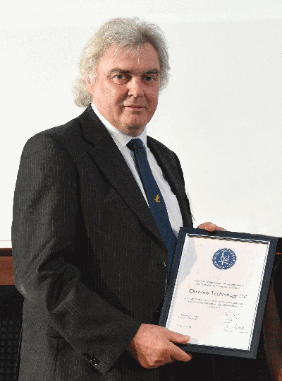
    Chronos Technology has been recognized by the Royal Institute of Navigation (RIN) with its 2018 Duke of Edinburgh’s Navigation Award for Outstanding Technical Achievement in “recognition of technical excellence and authority in satellite navigation and timing vulnerabilities and mitigations.”

    Charles Curry, founder and managing director of Chronos Technology, accepted the award at the RIN Annual General Meeting held June 10 in London.

    Chronos has worked with the RIN and others since 2008 to raise awareness of GNSS vulnerabilities, and in collaboration with the University of Bath has developed a family of GNSS interference detection products.

    Chronos first started researching this phenomenon with the University of Bath in the Innovate U.K. project GAARDIAN in 2008, closely followed by the SENTINEL and AJR projects. The projects have focused on detecting and locating commercial off-the-shelf jammers mostly sourced from Chinese websites.

    The first success was seizing the so called “Girvan Jammer” in 2011, when a jammer was recovered from a commercial van driver through collaboration with the serious and organized crime group of the local police.

    This exercise took about two weeks from initial detection to recovery of the jammer and should be compared to the six months it took U.S. enforcement agencies to identify the so called “Newark Jammer.”

    SENTINEL sensors were originally rolled out in 2010 continue to provide real evidence of jamming at various locations around the U.K. The project assists police work by collating jamming events by day and time of day using a cloud-based portal.

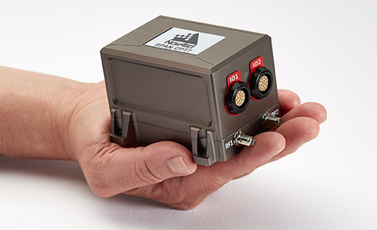
    The GPS interference detection portfolio includes low-cost, handheld GNSS interference detectors with features such as data logging and direction finding capabilities to precisely pinpoint a jammer.

    The latest product to emerge is known as “JammerCam,” and is the first GPS jamming detector in the world to be able to take photographs of a moving vehicle, which is carrying a GPS jammer. This is now in trials with various local police forces and is photographing vehicles with jammers on a daily basis, providing real-time actionable intelligence to the law enforcement officers’ smartphones identifying vehicle type, color and number plate.

    Early trials with this research are leading to the seizing of at least one jammer per week by U.K. law enforcement agencies.

    Chronos has demonstrated the ability to work with universities and potential users to develop new, affordable products to meet a genuine need. Customers include U.K. and international law enforcement agencies and military users.

    “This is a very prestigious award, as a look at the previous winners will attest,” said John Pottle, director of the Royal Institute of Navigation. “Chronos is very well respected and has continued to innovate, achieving global influence from their U.K. base. Many congratulations to all at Chronos for this well-deserved recognition.”

    Curry was awarded Fellowship of the Royal Institute of Navigation in 2016 in recognition of his significant and continuing contribution to the practical aspects of time measurement and dissemination, including research into GNSS vulnerabilities and the use of eLoran for precise time.

    “Chronos is honored to be the recipient of the RIN’s 2018 Duke of Edinburgh’s Navigation Award for Outstanding Technical Achievement,” Curry said. “We could not have done this without our close association with the University of Bath, in particular Dr. Robert Watson and Professor Cathryn Mitchell and their colleagues in the Electrical & Electronic Faculty.

    Over the years, this association has enabled Chronos to undertake research and bring to the market GPS jamming detection products which have been thoroughly field tested at locations such as Sennybridge in the Brecon Beacons, and other international jamming trials in Norway and the U.S.

    “In particular, Chronos was the only British company to be invited to JamX17 in Idaho Falls, U.S., by the U.S. Department of Homeland Security to showcase the detectors’ technology,” Curry said.

  • Interactive infographic by Geotab shows evolution of Interstate highways

    Geotab has released an interactive infographic depicting the evolution of America’s iconic Interstate Highway System.

    The interactive timeline allows users to watch the network expand over the years, providing a detailed look at the development of the infrastructure that has supported transportation and trade across the America for several decades.

    Today, the Interstate Highway System accounts for 25 percent of all highway traffic in the United States. As the system nears a major milestone, with the total network approaching 50,000 miles in length, Geotab created the interactive infographic to highlight the development of the highway system in the U.S. throughout the years.

    Since its inception in 1956, the Interstate Highway System has been regarded as the backbone of U.S. commerce and infrastructure, playing a vital role in America’s economic growth. The map highlights major developments over the last 60 years, such as the 1974 completion of the I-5 that now connects Mexico and Canada with a singular route and the opening of the I-80, the country’s first coast-to-coast highway.

    Geotab’s “Evolution of the Interstate” infographic provides the public with the ability to watch the Interstate Highway System expand over the years, enabling them to engage with particular dates and sections of the extensive network. The interactive map also includes relevant details about the city each highway serves, the length of that specific highway, and provides the total mileage covered by the entire network in any given year.

    “As America’s Interstate Highway System approaches a major milestone, we wanted to pay tribute to this intricate and expansive network,” said Maria Sotra, vice president of marketing at Geotab. “Connecting people, enabling business and providing a straightforward path across one of the largest countries in the world, the nearly 50,000 miles of highway that makes up the Interstate Highway System has played an undeniable role in transportation and trade in the United States.”

    Explore the interactive map.

  • New NovAtel system combines GNSS+INS in small package

    New NovAtel system combines GNSS+INS in small package

    NovAtel is now delivering its SPAN tightly coupled GNSS+INS navigation technology in a rugged, ultra-compact unit.

    Commercially exportable and designed for integration into a wide variety of applications, the high-performance SPAN CPT7 delivers assured positioning anywhere, in a package one-quarter the size of the company’s SPAN-CPT.

    SPAN technology leverages generations of precise positioning expertise and advanced algorithms to tightly couple GNSS and inertial navigation system (INS) measurements. The system enables continuous, robust positioning and fast reacquisition in challenging navigation environments where GNSS signals may be unreliable or unavailable for short periods.

    The new SPAN CPT7 also incorporates dual antennas to deliver instant alignment, along with interference detection and mitigation using NovAtel’s OEM7 Interference Toolkit (ITK) technology.

    Integrators can take advantage of a spectrum analysis function of ITK to identify interference within the GNSS frequency bands and whether interference is coming from the external environment or due to other components in an integration project, NovAtel said. Mitigation features within ITK allow developers to implement digital filters and eliminate the problem.

    Combining the multi-frequency, multi-constellation technology of the OEM7720 receiver board with ITK and the high-performing micro-electromechanical systems (MEMS) IMU, the SPAN CPT7 delivers anti-jamming functionality in an ultra-compact enclosure that fits in the palm of your hand. When paired with the GPS Anti-Jam Antenna (GAJT) in military applications, SPAN CPT7 is an integral part of assured position, navigation and timing (A-PNT).

    “The remarkable new SPAN CPT7 delivers solutions for defense, mobile mapping, and autonomous vehicle applications with more flexibility than ever before,” said Neil Gerein, director, product management, NovAtel. “This new product saves customers space and weight without compromising accuracy or performance.”


    Photo: NovAtel

  • CTSi flight tests navigation prototype to replace GPS for Navy

    CTSi flight tests navigation prototype to replace GPS for Navy

    An F/A-18F Super Hornet assigned to Strike Fighter Squadron (VFA) 102 launches from the flight deck of the aircraft carrier USS Ronald Reagan on July 10, 2018. (Photo: U.S. Navy/ Mass Communication Specialist 2nd Class Kenneth Abbate/Released)

    Along with partner L3 Technologies, the Enhanced Link Navigation System (ELNS) offers new solution to defeat enemy countermeasures to detect and disrupt allied signals.

    CTSi and partner L3 Technologies this month completed flight-testing of a newly developed integrated communication and navigation system for use in highly contested and GPS-denied environments.

    Designated the Enhanced Link Navigation System (ELNS), the prototype was built under a U.S. Navy $8.7 million Small Business Innovative Research (SBIR) Phase III contract and flight tested at the St. Mary’s County Regional Airport near Patuxent River, Maryland.

    “Our team put ELNS in the air in less than 18 months. It worked the first time and every time during 15 flights, which included 152 approaches,” said Ian Gallimore, CTSi chief technology officer. He went on to say that ELNS provided area navigation to replace GPS at ranges in excess of 50 nautical miles all the way through landing.

    Pilots from Airtec, who provided turn-key flight test support, said during test events, “These needles are… money,” and “ELNS is as good as any instrument landing system I’ve flown, I’d fly it in the weather.”

    “ELNS is scalable for unmanned aircraft in all groups, from those needing high integrity like MQ-25, to small unmanned aircraft on tight weight budgets,” said Martin King, Navy project manager. “ELNS is the first system to bring GPS-denied navigation capability to small UAS. By combining significant investments in related fields to create a whole new capability like this, ELNS takes position, navigation and timing (PNT) for air vehicles in a compelling new direction.”

    ELNS utilizes L3 Technologies’ waveforms that defeat adversary strategies to detect and disrupt allied signals, using waveforms that are essential in communications-denied and GPS-denied environments.

    “There is a strong fit between what ELNS brings and the threats that our forces are facing today,” said Tom Sanders, CTSi chief executive officer.

    To learn more about ELNS, contact [email protected].

  • Honeywell brings military precision navigation capabilities to commercial markets

    Honeywell has produced a new inertial navigation unit that provides accurate navigation for customers across a broad range of industries including agriculture, robotics and autonomous vehicles, without compromising on size, cost or performance.

    The HGuideN580 inertial navigation technology improves accuracy in urban and rural environments. (Photo: Honeywell)

    The HGuide n580 is the first Honeywell-produced, industrial-focused navigation solution that uses both precision inertial measurement unit technology and GNSS to improve location accuracy even when facing natural and manmade obstacles.

    “The blend of inertial and satellite navigation capabilities provided by the HGuide n580 is especially important where precision is required in demanding environments — for example, autonomous cars traveling in cities, where our technology can extend the accuracy and performance of navigational systems while keeping passengers safe,” said Chris Lund, senior director, Navigation and Sensors, Honeywell Aerospace. “Honeywell’s history and expertise in navigation technology enables customers to implement this new wave of advanced technology into their own applications and operations.”

    Roughly the size of a deck of cards, the HGuide n580 gives Honeywell’s industrial customers the capabilities needed to navigate accurately in areas with limited satellite coverage, such as densely populated cities where tall buildings, underground tunnels, and multi-layer freeway stacks or bridges often create challenges to traditional GPS navigation.

    For a GPS unit to function properly, it requires a strong signal connection between the unit on the ground and multiple satellites in the sky to accurately orient its position. City infrastructure such as buildings and tunnels can temporarily block the signal between GPS unit receivers and satellites, creating urban canyons.

    With the HGuide n580 integrated system, Honeywell’s inertial measurement unit technology combines with GPS to act as a backup solution, which means the loss of GPS signal caused by an urban canyon does not result in a complete loss of navigation.

    To learn more about the new HGuide n580 solution and Honeywell’s other commercially available navigation technologies, visit the Honeywell Aerospace website.

  • Esri and Waze deliver near real-time data for smarter cities

    Esri and Waze deliver near real-time data for smarter cities

    Esri and Waze smart cities partnership grows. (Image: Esri)
    Esri and Waze smart cities partnership grows. (Image: Esri)

    Waze Live Alerts on traffic and infrastructure now available in ArcGIS Marketplace.

    Waze live alert data will now be available in Esri’s ArcGIS Marketplace for free to members of the Waze Connected Citizens Program.

    The Connected Citizens Program, a two-way sharing of publicly available traffic and road condition information, offers governments a stream of data, constantly updated in real-time, whenever they need it. This enables personnel to make data-driven infrastructure decisions and improves the efficiency of incident response.

    Waze, a free crowdsourced traffic and navigation app, is now fully supported by ArcGIS Online, where its live feed of mapped traffic alerts and other information, such as accidents, congestion and street damage, can be used in applications in minutes.

    “Municipalities can now leverage near up-to-the-minute reports without having to write code or purchase additional software,” said Andrew Stauffer, manager of civic technology at Esri. “Mapped Waze data is available immediately in all ArcGIS apps, where traffic engineers and even city planners can use it to maintain and build safer, more efficient transportation systems.”

    Municipal personnel like traffic engineers can start using this data to analyze where the biggest problems exist on the roads so they can create targeted solutions. For instance, by seeing exactly where the most crashes are occurring, engineers can know where they need to place more officers, replace street signs, or adjust the timing of traffic lights.

    “The Waze Connected Citizens Program is all about removing any barriers to innovation,” said Adam Fried, Waze Global Partnerships manager. “We want to help our partners leverage existing infrastructure and be able to make better data-driven decisions. Now, with just a couple of clicks, a city can easily access and analyze Waze data within Esri ArcGIS and use those insights to improve roadway management and build safer roads for its citizens.”

    Much of the information government organizations rely on to make decisions is becoming obsolete as communities are starting to use technology like sensors and drones to monitor the quality of roads, bridges, and utilities. The Waze Connected Citizens Program gives municipalities the power to harness crowdsourced driver data to not only improve safety and congestion but also make better-informed decisions by giving planners an edge to start building infrastructure that meets the demands of a twenty-first-century city.

    Governments can sign up for the free Waze Connected Citizens Program and start working with the alert data in ArcGIS to create operational dashboards that departments can use right away.

  • EOS Platform provides toolbox for processing Earth observations

    Most image analysis tasks that required ENVI or Erdas Imagine software are now available online with EOS Platform, a new cloud service launched by Earth Observing System (EOS). It provides GIS professionals with a one-stop solution for search, analysis, storing and visualization of large amounts of geospatial data.

    EOS Platform is an ecosystem of four mutually integrated EOS products, which together provide a powerful toolset for geospatial analysts, according to the company. Image data obtained from LandViewer or uploaded from a user’s computer is stored in cloud-based EOS Storage and is instantly available for remote sensing analysis or image processing.

    EOS Processing offers 16 processing workflows that run online, including raster tools (merge, reprojection, pansharpening), remote sensing analytics, photogrammetry and proprietary feature extraction algorithms designed by EOS engineers and data scientists to address the main challenges of agriculture, forestry, oil, gas, retail, city planning, defense and other industries. Such pre-processing tasks as cloud detection or radiometric calibration refine raw data for further analysis. Images can be corrected for atmospheric effects to obtain the real ground radiance or reflectance values.

    Users can also use the cartographic features of EOS Vision for vector data visualization and analysis (analysis coming soon). Other features in upcoming updates include lidar analysis and 3D modeling.

    Data agnostic platform

    Users can work with a variety of satellite and airborne raster datasets in EOS Processing, EOS Storage and LandViewer, which enables quick and intuitive search of images within collections of Sentinel-1 and 2, Landsat 8 and 7, MODIS, NAIP, CBERS-4, Landsat 4 and 5. Besides downloading images from public datasets, users can also upload their own GeoTiff, JPEG, JPEG 2000 files and apply GIS data-processing algorithms via API or from the web interface. EOS Vision is a tool for vector data operations with multiple format support (ESRI Shapefile, GeoJSON, KML, KMZ).

    Object detection, change detection and classification

    The convolutional neural networks, pre-trained by EOS to extract features from imagery, allow users to apply state-of-art methods to detect objects and track changes from space.

    • Having only a set of multi-temporal images and change detection workflow, users can track how illegal deforestation progresses over time.
    • Edge detection can show the exact boundaries of agricultural lands down to the last pixel.
    • It is possible to estimate the parking lot traffic of the largest shopping centers with a car detection algorithm.

    Products within EOS Platform support almost all remote sensor types. Users can choose from numerous spectral indices to calculate on the fly.

    Aside from the complete set of vegetation indices (Normalized Difference Vegetation Index, NDVI; Red-Edge Chlorophyll Index, ReCI; etc.), there are also indices to outline landscape features (Normalized Difference Water Index, NDWI; Normalized Difference Snow Index, NDSI) and burned areas (Normalized Burn Ratio, NBR).

    One of the most useful features is the ability to experiment with spectral bands: users can create custom band combinations and indexes on top of the default ones.

    The user-friendly interface of EOS Processing makes it easy to manage processing workflows depending on the user’s business needs. Users can set the parameters for processing and repeatedly use customized workflows to automate high-frequency analytical tasks. Coming updates will add an ability to create custom algorithms from the available data-processing operations.

    Agriculture, forestry, oil and gas and more industries

    A tandem of EOS products form a comprehensive toolbox both for general use and for industry-specific cases, the company said. With vegetation indices and crop classification feature, agronomists can continuously monitor crop conditions to detect plant diseases, pests and droughts. Forestry specialists can classify forest types, assess fire damage, monitor forest health, and track and enforce logging restrictions.

    EOS Platform can also be used for regional and urban planning. It helps users identify land cover classes to generate a vegetation map and can also make a complete list of urban features such as buildings, roads or other major features in the region.

    The platform can tackle disaster management by measuring flood extent and finding fire boundaries. When it comes to oil and gas, it is capable of identifying oil rigs and assessing the environmental impact.

  • 4 Galileo satellites fueled for July 25 launch

    4 Galileo satellites fueled for July 25 launch

    Technicians in SCAPE (Self Contained Atmospheric Protection Ensemble) suits fill Galileo satellites 22-26 with hydrazine fuel. (Photo: ESA)

    Europe’s next four Galileo satellites have been fueled at Europe’s Spaceport in Kourou, French Guiana, in preparation for their launch on July 25, according to the European Space Agency (ESA).

    The four satellites were placed into their protective containers to be transported from the S1A processing building to the S3B payload preparation building, where they were filled with the hydrazine fuel that will keep the satellites manoeuverable during their 12-year working lives.

    The next step is to fit the quartet onto the dispenser that holds them in place securely during launch and then releases them into space once the upper stage of the Ariane 5 rocket reaches its 22,922-kilometer-altitude target orbit.

    After that, the satellites plus dispenser will be fitted onto the upper stage then enclosed by the two sides of the protective launch fairing — one of which has had the mission logo added to it.

    Meanwhile, the Ariane 5 for this launch (Flight VA244) has undergone assembly inside the Spaceport’s Launcher Integration Building.

    Galileo’s Flight VA244 mission logo is attached to the Ariane 5 fairing ahead of the July 25 four-satellite launch. (Photo: ESA)
  • AUVSI launches unmanned maritime systems advocacy committee

    The Association for Unmanned Vehicle Systems International (AUVSI) has formed an Unmanned Maritime Systems (UMS) Advocacy Committee to focus on the development of policy positions to support the advancement of the industry.

    “Unmanned maritime systems allow military and commercial operators alike to go farther and deeper than ever before,” said Brian Wynne, president and CEO of AUVSI. “The input provided by the UMS Advocacy Committee will help us speak with a unified voice and enable all our members to advocate for the growth of the industry.”

    The UMS Advocacy Committee will be chaired by Thomas Reynolds, vice president of business development for Hydroid Inc./Kongsberg Maritime. Reynolds, who leads all Kongsberg Maritime business with the U.S. government, previously served as a commissioned officer in the U.S. Navy, where he served as commander of the Explosive Ordinance Disposal Task Group, U.S. Fifth Fleet, among other roles.

    Reynolds holds a bachelor of science degree from the U.S. Naval Academy and an executive master of business administration from Benedictine College.

    Wayne Prender, vice president for Applied Technology and Advance Programs at Textron Systems, will be the committee’s vice chair. In his role at Textron, Prender is responsible for engineering development programs, advancing areas such as the Common Unmanned Surface Vehicle and Cased-Telescoped Weapons and Ammunition, as well as emerging capabilities and development programs.

    Prender is a former commissioned officer in the U.S. Army, where he was deployed to Iraq and awarded the Bronze Star. He holds a bachelor’s degree in mechanical engineering from St. Louis University, a master’s degree in technology management and a master of business administration from the University of Maryland University College.

    The committee also includes representatives from BAE Systems, L3 Technologies, Leidos, Lockheed Martin, Northrop Grumman and Seaborn Defense.

    The UMS Advocacy Committee formalized a set of policy priorities to help guide the committee’s legislative and regulatory actions. The priorities state that the committee shall:

    • Establish the UMS Advocacy Committee as the preeminent industry voice influencing acquisition and regulatory policies and processes.
    • Facilitate the growth of UMS through active engagement with the government and commercial sectors.
    • Collaborate with ship owners, operators, shipyards, ports, federal maritime agencies, technology developers, classification societies and academia to further integrate advanced automation for maritime platforms into the domestic market.
    • Develop the future of the UMS workforce through technology-focused education.
  • STMicroelectronics offers automotive-grade inertial sensor

    STMicroelectronics has introduced the automotive-grade ASM330LHH six-axis inertial sensor for super-high-resolution motion tracking in advanced vehicle navigation and telematics applications.

    Photo: STMicroelectronics
    Photo: STMicroelectronics

    Serving demands for continuous, accurate vehicle location to support automated services, the ASM330LHH lets advanced dead-reckoning algorithms calculate precise position from sensor data if satellite signals are blocked, such as in urban canyons, tunnels, covered roadways, parking garages or dense forests.

    Its advanced, low-noise, temperature-stable design enables dependable telematics services such as e-tolling, tele-diagnostics and e-Call assistance. Precision inertial data in six axes also meets the needs of advanced automated-driving systems, the company said.

    Automotive component manufacturer Magneti Marelli has selected the ASM330LHH for advanced telematics systems, to be fitted as original equipment by global automotive groups in upcoming vehicle ranges.

    For the ASM330LHH, as with all its MEMS sensors, STMicroelectronics owns the entire manufacturing process, from designing the sensors, through wafer fabrication, packaging, test, calibration and supply. Full end-to-end control enables STMicroelectronics to create high-performing sensors and assure customers of a robust and responsive supply chain, with rigorous end-of-line quality screening, the company said.

    “STMicroelectronics is the largest supplier of MEMS sensors for automotive non-safety applications, such as navigation and telematics,” said Andrea Onetti, Analog, MEMS and Sensors Group vice president at STMicroelectronics. “Our latest-generation inertial sensor, the automotive-grade ASM330LHH, enables precise positioning for safer, smarter driving.”

    Engineering samples will be available for evaluation by the third quarter of 2018, and volume production will begin the following quarter.

    Further technical information on the ASM330LHH

    • Temperature range up 105 degrees Celsius giving designers extra freedom to locate electronic controls in hot areas such as in smart antennas on the vehicle roof, or near the engine compartment.
    • Ultra low noise allows greater measurement resolution by minimizing integration errors when positioning is reliant on sensors only.
    • High linearity and built-in temperature compensation eliminate any need for external compensation algorithms over its operating range.
    • Lowest power consumption in class, with features for optimizing power management if battery usage becomes crucial.
    • Qualified according to AEC-Q100 automotive-grade robustness standard.
    • Built on STMicroelectronics’ proven, proprietary ThELMA MEMS process technology, which enables integration of both the three-axis accelerometer and three-axis angular-rate sensor (gyroscope) on the same silicon for optimum yield, quality, and reliability.
    • The electronic interface integrates the signal chain for both sensors on a single die using STMicroelectronics’ 130nm HCMOS9A technology.
    • Reference designs, as well as STMicroelectronics’ Teseo satellite-positioning modules and related software are available. The dead-reckoning algorithm included with the Teseo III GNSS-receiver chipset already supports the ASM330LHH to generate a high-accuracy output suitable for autonomous navigation.
    • Tiny, low-profile 3mm x 2.5mm x 0.83mm device for minimal impact on the size of any on-board module.
    • Packaged as a leadless Land Grid Array (LGA) device.
  • MapVault streaming service issues new release

    East View Geospatial (EVG) is offering a new version of MapVault, a streaming service that brings together maps from around the world.

    According to the company, MapVault provides access to more than 500,000 geo-referenced map sheets from more than 1,000 authoritative map series, which can save organizations the costs of procuring, storing and digitizing physical maps.

    MapVault users have access to a diverse collection of topographic, aeronautical, nautical and geological map series sourced from international mapping agencies. Each series has been mosaicked for easy use and quick navigation. Robust metadata along with series index maps and individual sheet-level metadata are included.

    New map series are added to MapVault on a regular basis, and subscriptions are customizable. Users can choose to subscribe to the series that cover their exact areas of interest or select from multiple regional package options.

    East View Geospatial also provides custom series solutions and encourages users to contact the company about adding their own mapping resources to the MapVault platform.

    MapVault was designed for a wide variety of users, both GIS and non-GIS specialists, and data is easily integrated into GIS software, the company said. The MapVault catalog can be accessed over the internet or through any WMTS (web mapping tile services) connection. Layer files formatted specifically for ArcGIS Desktop, QGIS, Global Mapper or other open-source GIS packages can be downloaded.

    “What makes MapVault unique is the many advantages it brings to users,” said Kent Lee, president and CEO of East View Geospatial. “We’ve taken the time and cost out of tiling entire map series, giving users consistent, reliable data served up in a straightforward, easy-to-use streaming service. Whether you are interested in global or country-wide mapping coverage, or even county- or city-level mapping, MapVault gives users of all experience levels a simple and accessible environment in which to discover and utilize maps.”

  • FAA surveys commercial drone operators

    FAA surveys commercial drone operators

    If you’ve registered a commercial drone, the U.S. Federal Aviation Administration (FAA) wants to hear from you.

    On June 19, the FAA sent a questionnaire to everyone who has registered a commercial drone – more formally, an unmanned aircraft system (UAS) — for anything but recreational or hobby use.

    Most of these owners fly their drones for commercial purposes, but the survey population also includes government departments and other users.

    Hobbyists are not included in this survey.

    The goal is to collect information on drone flight activities under the FAA’s small drone rule (Part 107), data that will help the FAA improve the services it delivers to the UAS community. Responses to the questionnaire are voluntary and entered 100 percent electronically.

    The survey will take about 10 minutes to complete.

    The questions include areas such as number of drones registered, number and types of missions completed in 2017, primary locations where the operator flies and types of waivers requested. The survey also asks how operators want to get information about drone-related issues from the FAA, and how satisfied they are with the news channels they use now

    The questionnaire is completely anonymous, so responses cannot be attributed to an individual.

    If the questionnaire is still sitting on your computer or mobile device, the FAA wants —  and needs — your input.