HxGN SmartNet has partnered with AZGPS LLC to expand access to quality network correction services for GNSS users in the southwestern United States.
HxGN SmartNet, a high-precision, high-availability GNSS network correction service, is provided by Hexagon’s Geosystems division. AZGPS, based in Florence, Arizona, serves professionals across Southern California and Arizona who rely on high-precision GNSS with network correction services, professional support and training.
The company will remain the local point of contact in the region and now has access to the infrastructure and resources of HxGN SmartNet, including HxGN SmartNet stations and a wide array of Hexagon services.
“Our number-one goal is to help our customers succeed,” said Travis Thompson, AZGPS. “The ability to leverage the resources of HxGN SmartNet will enable AZGPS to provide even more benefits to GNSS users. We look forward to continuing the superior service our customers have come to rely on for more than 13 years while staying on the leading edge of technology.”
HxGN SmartNet is fully open to all makes and models of GNSS equipment and is designed to provide the highest reliability and accuracy 24/7. Launched in 2010, HxGN SmartNet is a commercial GNSS network that offers a single connection point for coverage across North America.
Built on the most advanced GNSS reference station software platform in the world, Leica Geosystems GNSS Spider, HxGN SmartNet provides high-precision, high availability network real-time kinematic (RTK) corrections for any application, the company said.
A variety of different subscription plans are available at the state, regional and national level for any application requiring precision GNSS corrections. With more than 1,300 stations in 45 states and eight provinces, HxGN SmartNet North America offers extensive network coverage.
“GNSS users across all applications know they can rely on HxGN SmartNet to make the investments and partnerships needed to provide the easiest, fastest and most precise positions in the industry,” said Wendy Watson, director of operations for HxGN SmartNet North America. “AZGPS has a long track record of providing excellent service to GNSS users in the Southwest through the AZGPS and CALVRS networks. This cooperation between two familiar names in the positioning services industry underscores HxGN SmartNet’s commitment to ‘any constellation, any application and open to all.’”
(From left) Francois Lombard and Dirk Hoke, Airbus, sign agreement with Will Marshall, Planet.
Airbus and Planet have entered into a partnership to facilitate access to each other’s data and the co-development of new geospatial solutions.
The companies are establishing a framework agreement to explore opportunities for joint cooperation in new and existing markets, product offerings, sales and marketing efforts.
Both companies aim to provide a comprehensive suite of global satellite data at multiple temporal and spatial resolutions, and develop new analytic products for a wide range of applications to benefit their customers.
Benefitting from both companies’ constellations, customers will have access to the entire Earth’s landmass every day at 3m resolution with PlanetScope satellites, as well as to intra-daily sub-meter resolution imagery with Pléiades and SkySat constellations.
In addition, they will also have the capability to order images with resolutions of 1.5m (SPOT 6/7), 5m (Rapideye) and 22m (DMC Constellation).
Lastly, TerraSAR-X, TanDEM-X and PAZ radar satellites will allow the acquisition of images regardless of weather and daylight conditions, ensuring access to any place on Earth independent of cloud coverage.
“By combining our strengths, we will provide a key capability to address all market needs, both in terms of data and value-added products, and to best serve our clients, whatever their industry and their requirements,” said François Lombard, director of the Intelligence Business at Airbus Defence and Space.
“Airbus and Planet are truly complementary partners. Airbus brings long-standing success in serving reliable, high resolution remote sensing, and Planet brings its unique global coverage and temporal cadence, as well as agile aerospace iteration to get sensors quickly to space,” said Will Marshall, CEO and co-founder of Planet. “Together we will be able to deliver sophisticated offerings to fit customer needs across international markets.”
Ceva has launched the successor to its Ceva-Dragonfly NB1 solution targeting the NB-internet of things (IoT) market, the Ceva-Dragonfly NB2.
The Dragonfly NB2 is a highly integrated and modular solution optimized for Cat-NB2 (3GPP Release 14 eNB-IoT) that can seamlessly be incorporated into chips and modules by the multitude of companies looking to address the large and fast-growing cellular IoT space.
GNSS hardware package. For customers developing NB-IoT products that also require GNSS capabilities, Ceva-Dragonfly NB2 includes a new power-optimized GNSS hardware package, with GNSS RF receiver and multi-constellation digital front-end.
The GNSS package speeds up both acquisition and tracking tasks by up to 8 times compared to Ceva-Dragonfly NB1, enabling a host of popular NB-IoT use cases, including people, livestock and asset tracking, and geo-fencing, the company said.
IoT boom forecast. In the latest edition of the Ericsson Mobility Report, the forecast for cellular IoT increased significantly, almost doubling to 3.5 billion connections for 2023. The report cites large-scale deployments in China and increasing interest in eNB-IoT and Cat-M1 cellular IoT standards as the catalysts for 30 percent CAGR between 2017 and 2023.
Ceva-Dragonfly NB2 is a licensable Rel14 compliant eNB-IoT solution and builds on the success of Ceva-Dragonfly NB1, which has been widely licensed for a range of use cases and emerging end markets, including smart cities, transport and logistics and consumer electronics. It is centered on the Ceva-X1 DSP/control processor featuring an enhanced Instruction Set Architecture and provides a unified processor environment for both physical layer and protocol stack workloads.
The solution also includes a highly integrated, worldwide enabled RF transceiver, a power amplifier (PA) and all the associated hardware and software modules required to develop a complete eNB-IoT product, ensuring the lowest possible bill-of-materials (BOM) in the process.
In addition to the performance improvements enabled by Release 14 including higher data rates and lower latency, Ceva-Dragonfly NB2 features a range of enhancements to ensure higher performance, added functionality and increased security for NB-IoT applications compared to its predecessor.
A new power management solution, complete with intelligent sleep mechanisms ensures ultra-low sleep power consumption of a few microAmps, further improving the battery life critical to every NB-IoT device.
The enhanced RF design is already silicon-proven at 55nm and 40nm processes, further lowering the entry barriers for customers with no previous cellular expertise to enter this burgeoning market.
Ceva-Dragonfly NB2 also includes the fully optimized physical layer and protocol stack firmware designed for Release 14 Cat-NB2. The addition of an on-chip embedded flash memory and controller now allows full NB-IoT design on a single die which further reduces BOM and power consumption.
Voice trigger. Ceva-Dragonfly NB2 also supports use cases requiring always-listening voice trigger, voice commands and sound sensing. The flexibility of the Ceva-X1 IoT processor allows for these sensing features to be implemented in software. The Ceva ClearVox voice front-end software package, for example, can be used to ensure clear and intelligible voice pickup for use cases such as emergency calls and voice panic buttons. In terms of security, Ceva-Dragonfly NB2 integrates a completely redesigned secure platform, including smart interfaces to connect USIM or eSIM. Ceva also offers other complementary technologies addressing massive IoT, such as Bluetooth 5 dual-mode and low energy and Wi-Fi 802.11n/ac/ax, for short range connectivity which customers can leverage for their product designs.
“The widespread commercial deployment of NB-IoT is well underway across the globe and we’re proud to be at the forefront of technology innovation for long-range massive IoT,” said Michael Boukaya, vice president and general manager of the wireless business unit at Ceva. “With the introduction of Ceva-Dragonfly NB2, we have built on the considerable success we achieved with our first generation solution, and delivered a unique, silicon-proven eNB-IoT Release 14 solution for our customers that is unprecedented in terms of system completeness, performance and power efficiency.
“Moreover, the option of power-optimized GNSS, voice and sensing capabilities vastly increases the breadth of use cases our customers can address with this licensable solution,” Boukaya said. “There is no other IP company in the world today that can come close to offering such a complete solution for eNB-IoT and we’re excited to closely partner with our customers to create a whole new wave of applications and devices for the infinite Internet of Things.”
Ceva-Dragonfly NB2 is available for licensing now. Development kits and reference silicon will be available in the third quarter of this year.
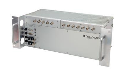
Oscilloquartz has launched its enhanced primary reference time clock (ePRTC) system to enable unprecedented timing accuracy and stability, even when the GNSS signal is lost.
The system provides a timing source for mission-critical transport systems, such as utility networks, government infrastructure and radio access networks, and provides the strict synchronization needed for LTE-A and 5G applications, the company said.
The Oscilloquartz 3230B.
Featuring the OSA 3230B ePRC atomic cesium clock connected to an Oscilloquartz clock combiner and grandmaster, the new solution offers the extremely stable frequency of a cesium clock with the UTC-traceable signal provided by GNSS.
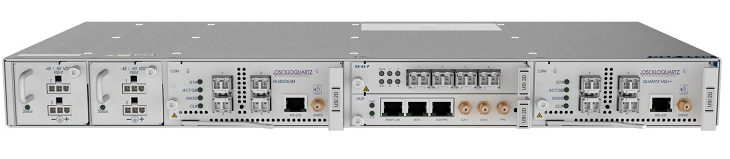
When combined with the OSA 5430, the OSA ePRTC system provides full hardware redundancy and multiple fan-out options including PTP over 10Gbit/s.
“With our ePRTC system, we’re taking reliability and accuracy to the next level. This solution meets the requirements of next-generation mobile networks, offers the precise synchronization needed by many of today’s industries and removes vulnerability to GNSS outages,” said Gil Biran, general manager, Oscilloquartz.
The Oscilloquartz OSA 5430.
“Combining our advanced multi-constellation GNSS receiver with our atomic cesium clock technology creates an outstandingly accurate source of time with guaranteed holdover performance,” Biran said. “This provides vital protection against loss of satellite signal due to jamming, which can be a major problem.
“With the flexibility and redundancy of our OSA 5430, operators can deploy a precise, secure and robust UTC-traceable time and frequency source with high capacity. What’s more, the Syncjack sync probing and assurance technology embedded in our ePRTC enables detection and reporting of inconsistencies between the different references provided to the ePRTC as well as detection of the GNSS spoofing.”
GNSS interference concerns
The dangers of reliance on GNSS alone have become a serious concern across a wide range of industries. Without backup, loss of signal would have a profound impact on critical infrastructure, financial institutions, and military capabilities.
PTP packet-based mobile networks are also highly susceptible to outages unless they are able to hold time and maintain accuracy when GNSS is unavailable.
The OSA ePRTC system removes this vulnerability while delivering higher performance levels than standard PRTC systems and giving operators control of their network synchronization.
The solution comprises two OSA devices: an OSA 3230B ePRC cesium clock compliant to G.811.1 ePRC, which is connected to either an OSA 5421 or OSA 5430 clock combiner and grandmaster clock compliant to G.8272.1 ePRTC. This provides phenomenal holdover accurate to UTC within +/-100 nanoseconds for up to two weeks, ensuring resilience and optimized performance.
“Our OSA ePRTC system is about leveraging the advantages of both timing methods, ensuring the long-term accuracy of GNSS alongside the stability of a cesium beam atomic clock. It even provides major benefits when locked to GNSS by delivering a three-fold improvement in timing accuracy,” said Nir Laufer, product line director, Oscilloquartz.
“In recent years, we’ve seen a big increase in GNSS vulnerabilities due to deliberate spoofing and jamming attacks as well as the natural threats of solar flares and space weather events,” Laufer said. “From global data centers to government institutions, there’s now an urgent need to move away from reliance on GNSS alone. Ensuring backup is now a mandatory step towards secure synchronization. And with our OSA ePRTC, this can be achieved without adding a lot of cost and complexity. We’re giving operators peace of mind and the power to do more with existing infrastructure.”
The Federal Aviation Administration’s Geosynchronous Earth Orbiting 5 Wide Area Augmentation System (WAAS) navigation payload, developed by Raytheon’s Intelligence, Information and Services business, is now operational and fully integrated into the WAAS network.
The GEO 5 payload joins two others already on orbit in correcting GPS satellite signal ionospheric disturbances, timing issues and minor orbit adjustments, giving users increased coverage, improved accuracy and better reliability, Raytheon said.
“GPS alone can’t meet the FAA’s stringent requirements for accuracy, integrity and availability,” said Matt Gilligan, vice president of Raytheon’s Navigation, Weather and Services mission area. “The WAAS network corrects even the slightest errors, and that provides peace of mind when it comes to safety of flight.”
In operation since 2003, WAAS increases GPS satellite signal accuracy from 10 meters to 1 meter, ensuring GPS signals meet rigorous air navigation performance and safety requirements for all classes of aircraft in all phases of flight, Raytheon added.
WAAS provides precision navigation service to users across the United States from Maine to Alaska, as well as portions of Canada and Mexico.
For aviation users, WAAS offers pilots more direct flight paths, precision airport approaches and access to remote landing sites without depending on local ground-based landing systems.
Raytheon is the system integrator on the GEO 5 system, which includes a WAAS navigation payload on Eutelsat’s GEO satellite, two ComSAT ground sites and SED Systems specialized equipment.
Testing of the three Galileo apps took place in May. (Photo: ESA)
ESA challenged its young graduate and national trainees to develop a smartphone app to perform satnav fixes using only Galileo satellites.
Three teams developed apps in their spare time, presenting their results to a jury of experts from ESA, the European Global Navigation Satellite Systems Agency (GSA) and Google.
“I’m very impressed,” said Javier Benedicto, ESA’s Galileo programme manager. “With little detailed knowledge of satellite navigation, these teams have developed something that didn’t exist just a few months ago. Working on Galileo we love to see that the systems we’re putting together can reach widespread application and inspire new uses.”
The winning Galfins Team put together the GNSS Compare app that promises to turn a smartphone into a “research lab in your pocket” to test Galileo performance in isolation or in combination with other systems. Their prize is to attend an ESA and European Commission-sponsored GNSS Summer School in Austria.
The final presentation and results of ESA’s internal Galileo smartphone app competition took place in the Erasmus centre of ESA’s Erasmus technical centre on May 31. (Photo: ESA)
“Only one of our four-strong team started the challenge with any knowledge about satellite navigation,” said Mateusz Kraiński of the Galfins team. “The rest of us come from different areas — for example, I’m working on the European Robotic Arm project, due to launch at the end of next year. We have learnt a lot and the radio navigation experts at ESTEC were a great source of support.”
“We see a need on the market for such an application, so we will definitely continue with the development. The application will be made available for download when ready, and the project will be released as open source soon after.”
The other two teams were also commended for their work; Chocolateam developed a richly-designed game-based app, giving the user the feeling of observing the Galileo satellites from a spacecraft, while Team 5G distinguished themselves by writing all their own navigation algorithms from scratch rather than relying on open source software.
The challenge was to design an Android smartphone app that allows users to compute and visualize their position based solely on Galileo measurements, as well as the possibility of selecting a combination of satnav constellations to assess their performance.
Testing the three apps entered in the Galileo smartphone app competition in the grounds of ESTEC, working in pedestrian mode. (Photo: ESA)
The receiver chipsets inside smartphones make use of Galileo signals in combination with several other satnav constellations — the U.S. GPS, Russian GLONASS and Chinese BeiDou. These chipsets function like “black boxes,” making the resulting positioning fix accessible to users, but not giving any option for the user to select which constellation to employ.
Current phone applications only display general satnav status information, such as which satellites are contributing to the positioning fix, their visibility parameters and overall power levels. This is not sufficient to single out Galileo’s contribution to the phone’s overall positioning performance.
However, in newer Android smartphones it has become possible to access the raw signal measurements used to compute position, opening the door to the development of applications where the user can indeed select which satellites to use.
The teams received one Galileo-enabled smartphone each for developing and testing the app.
ESA’s Director of Technology, Engineering and Quality supported the teams by supplying dedicated software modules to simplify computations of the phone position. During the competition, a technical advisory team also developed an internal app as a benchmark.
The app, named Galileo PVT and developed by ESTEC engineers Paolo Crosta and Tim Watterton, includes an augmented reality system allowing users to “see” the Galileo satellites from which they were receiving signals in the local sky.
“This was a very useful exercise because it helps us understand the needs of satnav app developers in Android,” said the lead advisor, Paolo Crosta. “Then, once the apps were complete, we tested them together, here on the grounds of ESTEC, working in stationary, pedestrian and vehicular modes.”
“Congratulations to all the teams here today,” said Frank Van Diggelen from Google, who had just come from a satnav raw measurements workshop hosted by GSA. “It’s been great to be here and see all the activity around raw signal measurements. Our aim has always been to raise standards by making these measurements available, to let developers see what’s happening inside. And the work you’re doing here is feeding back to chip and smartphone manufacturers, to help change and improve them for the future.”
“In partnership with Ligado Networks, we have demonstrated delivery of TerraStar X technology over both satellite and cellular networks to position vehicles with 5-centimeter (2-inch) accuracy in under a minute,” Hexagon stated in a press release. “Combining TerraStar X technology with multiple delivery channels is a significant step towards the future of Autonomous X, where cars, UAVs, industrial vehicles, trains and more will operate safely, securely, reliably and efficiently.
TerraStar X technology is built on the latest precise point positioning algorithms. According to the company, it leverages existing Hexagon capabilities in ground network infrastructure, correction data generation and data packaging for delivery.
By eliminating convergence time while providing high-accuracy global positioning, TerraStar X will form the future of Hexagon’s correction services for safety-of-life applications and Autonomous X.
When combined with automotive-grade GNSS receivers available through Hexagon Positioning Intelligence, the technology allows automotive customers to evaluate positioning performance in real time using data delivered over the cellular network or the L-band frequency using Ligado’s SkyTerra satellite in North America.
Trial networks for customer evaluation are available in California, Arizona and Michigan over satellite or cellular network, and in Germany using cellular delivery. The infrastructure is scalable, enabling timely geographic expansion to accommodate automotive development programs globally.
Commercial solutions designed for the automotive market will be available in 2019.
“Ligado’s expertise in satellite delivery and proactive involvement in this project enabled rapid deployment of our TerraStar X correction technology over the test area,” said Sara Masterson, positioning services segment manager with Hexagon’s Positioning Intelligence division. “Their unique spot-beam technology enables efficient delivery of the higher bandwidth correction data required for this application and adds a delivery method providing continental scale coverage.”
The geostationary Skyterra satellite operated by Ligado uses a 22-meter reflector-based antenna to deliver an L-band signal over North America. Several of the L-band DGPS/PPP service providers, including Terrastar, have used the Skyterra-1 satellite since its 2010 launch to support North American coverage.
Hexagon has been providing highly reliable, precise GNSS corrections under VERIPOS, TerraStar, Oceanix, and SmartNet brands for more than 20 years, the company said. It operates the world’s largest reference station network, consisting of more than 4,500 stations.
“Hexagon is uniquely positioned to offer end to end solutions from correction data generation through to GNSS positioning solutions in the vehicle,” said Brian Deobald, vice president, strategic product and ecosystem development, Ligado Networks. “We are excited to partner with Hexagon on this opportunity to demonstrate the delivery of TerraStar X technology, using high throughput, cost-efficient satellite connectivity to enable superior performance and reliability for autonomous driving applications.”
Ligado. This development has no relationship to the current Ligado Networks petition before the Federal Communications Commission to repurpose some of its mobile satellite systems spectrum to broadcast from ground-based transmitters. That matter is still pending, and there is currently no such signal being broadcast.
Leica Geosystems has released the Leica Aibot, its latest unmanned aerial vehicle (UAV) system based on DJI’s aerial platform, the M600 Pro, designed to rapidly and autonomously enable digitizing of critical infrastructure.
Leica Geosystems’ UAV technology enables users to get a complete data set in less time with a user-friendly and innovative interface, opening new business opportunities while reducing time, costs and effort from with traditional data collection methods.
A proprietary software suite supports the new UAV workflows. Using Leica Infinity for point cloud, digital surface model and orthophoto generation enables surveyors to process and visualize aerial data, increasing productivity and speeding data delivery. Supporting users to share data to Cylcone and Cloudworx, the integration of the UAV point cloud with terrestrial scan data enables informed decisions, while complete data sets increase project efficiency.
Use in construction
Throughout a construction project lifecycle of planning, designing and construction, Aibot provides easy access to critical information to perform volume calculations and monitor site progress. From creating digital terrain models to stripping and bulk earthworks and trenching to finally fine grading, paving and compaction, the solution facilitates actuals comparisons. This provides a more transparent view of site progression monitoring and volume calculations with safer operations, to keep projects on schedule.
High-definition imagery and 3D mapping enable viewing of site mapping or progress documentation, meaning users identify gaps early with high accuracy, and save time and money at all project stages.
Automating operations
The new technology, developed in partnership with UAV manufacturer DJI, allows users to process and analyze millions of data points gathered from above and to visualize the data for actionable information. UAV data can be combined with existing survey technologies, such as TPS, GPS and laser scanning, for a more complete set of information.
The European GNSS Agency (GSA) has issued a request for information (RFI) in preparation for the procurement of EGNOS geostationary navigation payload services.
The EGNOS space segment is provided by commercial satellite operators on the basis of service contracts. The GEO-1, GEO-2 and GEO-3 service contracts now cover the EGNOS space segment needs, and the GEO-1 and GEO-2 services will be the first of these to end, GSA reported. The GEO-1 and GEO-2 services will be replaced by new contracts, GEO-4 and GEO-5.
GSA is planning how it will replace the services delivered by the GEO-1 and GEO-2 satellites, and it’s issuing the RFI to collect information about opportunities to embark navigation payloads on board GEO satellites launched in a suitable time frame.
According to GSA, the results of the RFI will also be used to determine the best approach for the procurement of the payload services, which may be either procured at the same time or separately. It will help GSA define the tender specifications and decide on the most appropriate time to launch invitations to tender.
In addition, GSA aims to obtain information from owners of geostationary satellites that will be available for operational service from 2021 to 2027 and able to embark a navigation payload. The agency is specifically seeking information on future satellite plans and the possibility to embark SBAS payloads in due time to ensure an operational start date from 2021 to 2027.
The RFI will also request information service availability and long-term payload reliability; the process for EGNOS payload procurement, in-orbit testing and commissioning; information on the locations of the potential hosting sites for the EGNOS radio frequency uplink stations; and, finally, information on contractual arrangements, the payment scheme, and cost estimates, GSA added.
Answers to the RFI should be sent electronically to [email protected] by Aug. 31.
The Open Geospatial Consortium (OGC) is hosting the second Disasters Concept Development Study Workshop July 24-25 at the NOAA Auditorium in Silver Spring, Maryland.
Organized by OGC, the workshop is sponsored by the Department of Homeland Security, the Federal Geographic Data Committee, the U.S. Geological Survey (USGS) and other government agencies.
The workshop is part of the OGC’s Disaster Concept Development Study, and will shape future activities to be led by OGC regarding disaster preparedness and response, and to inform development of potential disaster spatial data infrastructures (SDI).
According to NOAA, in 2017 in the United States there were 16 major natural disasters with costs that exceeded 306 billion dollars, shattering previous annual records.
The workshop asks whether more lives can be saved and damages reduced by providing better discovery and access to data that will improve mitigation, preparedness, response and recovery from disasters.
The ability to effectively share, use and reuse geospatial information and applications across and between governments and non-government organizations in support of disaster response and resilience depends on having a spatial data infrastructure in place when disaster strikes.
The OGC is bringing together key stakeholders in the natural hazards disaster communities to advance the emerging Disaster SDI by conducting a study and developing a set of pilots over the coming years. OGC’s Disasters Interoperability Concept Development Study (CDS) will assess the current state of data and product exchange technologies as used in disaster planning, response, and recovery. The information gained in the CDS will aid in developing a series of future pilots that will in turn advance the state of SDIs that support disaster risk reduction across the globe.
For more information on the Disasters CDS Workshop, including the agenda and how to register, visit the event page on the OGC website. Registration for the workshop is free but mandatory.
Mobile brand Xiaomi has launched a dual-frequency GNSS smartphone.
Fitted with a Broadcom BCM47755 chip, the Xiaomi Mi 8 provides up to decimeter-level accuracy for location-based services and vehicle navigation, the company said.
The Mi 8 smartphone represents a breakthrough in GNSS technology as the first commercial deployment of Broadcom’s dual-frequency BCM47755 chip designed for the mass market and introduced in September 2017.
Until now, mobile location-based applications have been powered by single-frequency GNSS receivers whose location accuracy is limited to a few meters. However, in recent years GNSS systems have been launching satellites broadcasting signals on new frequencies to open up new possibilities. Specifically, Galileo has the majority of satellites with E1/L1 and E5/L5 frequency capabilities.
The E1/L1 + E5/L5 GNSS chip can compute location with an accuracy of up to a few decimeters.
Leveraging Galileo for increased accuracy
According to the company, users of the Xiaomi Mi 8 and future models with dual-frequency GNSS will benefit from better positioning and navigation experience in urban environments. This is due to the unique shape of the E5/L5 frequency, which makes it easier to distinguish real signals from the ones reflected by buildings, reducing the multipath effect, a major source of navigation error in cities and other challenging environments.
The numerous Galileo satellites broadcasting E5 make this improvement available for users all around the world. In addition, the simultaneous use of two frequencies reduces other sources of error, such as those due to the ionosphere, and the frequency diversity is more robust to interference and jamming.
In addition to making existing applications more accurate, the enhanced position precision offered by dual-frequency GNSS will also create opportunities for new applications in areas such as augmented reality, vehicle navigation and mapping.
Commenting on the product launch, European GNSS Agency (GSA) head of market development Gian Gherardo Calini said that the arrival of the first dual-frequency GNSS smartphone to the mass-market represents a breakthrough for users all over the world.
“The enhanced accuracy provided will empower developers to create new applications that meet the growing high-accuracy location requirements of users and also open up applications that previously only ran in dedicated devices intended for professional use,” Calini said.
“Broadcom is glad to gear up Xiaomi’s flagship smartphones with the very latest dual-frequency GNSS technology,” added Alex Chou, vice president of product marketing for the Wireless Communications and Connectivity Division at Broadcom. “Xiaomi Mi 8, the world’s first smartphone with BCM47755, will take smartphone GNSS navigation to a whole new performance level.”
”The importance of GNSS to modern life is undisputed, and is particularly important for smartphones,” said Zhiyuan Zang, Xiaomi’s director of product marketing. “Navigation and LBS-based apps these days require greater positioning accuracy to work effectively, and dual-frequency GNSS is the key to delivering a great user experience when using these apps. Xiaomi is delighted and honored to be the world’s first smartphone manufacturer to support dual-frequency GNSS. We will continue to pursue innovation for everyone to enjoy.”
Access to raw measurements for geolocation
The launch of the first dual-frequency GNSS smartphone, together with the opportunities offered by the availability of GNSS raw measurements in Android, creates exciting opportunities for the geolocation community, the company said.
Access to raw measurements opens the door to algorithms once restricted to more advanced GNSS receivers. This, in turn, allows users to fully benefit from the differentiators offered by Galileo.
Recognizing these opportunities, in 2017 the GSA engaged with academia and industry in the areas of navigation and positioning to innovate around this new feature as part of a GNSS Raw Measurements Task Force.
Then, in January, the GSA published a white paper on the use of GNSS Raw Measurements in Android, providing developers with in-depth information on accessing and using raw measurements to implement advanced GNSS techniques in mass-market devices.
Building on this work, the GSA and the Raw Measurements Taskforce shared their latest updates at a dedicated workshop — “GNSS Raw Measurements: From Research to Commercial Use” — held at the GSA headquarters in Prague on May 30, where Broadcom presented its encouraging test results from the dual-frequency BCM47755.
Airbus Defence and Space is celebrating the 25th anniversary of Eagle Vision, its lightweight deployable imagery downlink ground station designed to process and distribute commercial satellite imagery in near-real time to support U.S. Air Force and Air National Guard missions in homeland security, combat and disaster relief.
Eagle Vision allows downloading and processing of unclassified commercial satellite imagery directly in the field, as the satellite passes overhead, supporting military leaders, even in remote areas and non-anticipated operations. Imagery provided by this system supports wartime operations, natural disaster and relief efforts as well as Homeland Defense preparations.
“Today we celebrate an uninterrupted success since 1993,” said François Lombard, director of the intelligence business at Airbus Defence and Space. “Since then, Eagle Vision has become a valuable source for commercial imagery exploitation for the U.S. Air Force and many entities within the U.S. government, to provide fresh, near-real time satellite data for information extraction in preparation for mission critical applications.”
The system receives and processes SPOT 6 and 7, TerraSAR-X and Pléiades images, and is also capable of processing Landsat, Radarsat, RapidEye, Cartosat, Ikonos, Cosmo-SkyMed and Resurs-DK data.
The Eagle Vision Program has been a valuable asset within the U.S. Air Force for the past 25 years, the company said. The program enables warfighters, first responders and planners to have situational awareness so that they can plan, execute and deliver mission resources efficiently and effectively, Airbus said.
Five Eagle Vision systems have been developed and sustained 24/7 by Airbus Defence and Space for the last 25 years. They are assigned to:
Ramstein Air Base, Germany
San Diego Air National Guard Station, California
McEntire Joint National Guard Base, South Carolina


 The workshop is part of the OGC’s
 Eagle Vision allows downloading and processing of unclassified commercial satellite imagery directly in the field, as the satellite passes overhead, supporting military leaders, even in remote areas and non-anticipated operations. Imagery provided by this system supports wartime operations, natural disaster and relief efforts as well as Homeland Defense preparations.