Author: Tracy Cozzens

  • Quectel unveils 5G NR modules for commercial use of 5G SA devices

    Quectel unveils 5G NR modules for commercial use of 5G SA devices

    Photo: Quectel
    Photo: Quectel

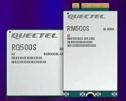
    Quectel Wireless Solutions, a global supplier of modules for the internet of things (IoT), has announced the release of two new 5G New Radio (NR) module series, the RG500S and RM500S.

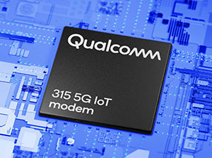
    Based on the new Qualcomm 315 5G IoT Modem-RF System, both modules can support customers in building dedicated 5G devices for a variety of verticals including industrial IoT, retail, smart energy, private 5G networks, and many others.

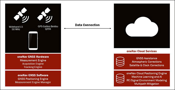
    The RG500S and RM500S both integrate a multi-constellation GNSS receiver, which simplifies the product design and provides accurate positioning services for users.

    Utilizing the powerful Qualcomm 315 5G IoT modem, the RG500S and RM500S support extended-life software maintenance, helping create long-lasting IoT devices for the duration of their life span. Offering seamless integration, the RM500S is pin-to-pin compatible with Quectel’s LTE Cat 4 module EM05, Cat 6 module EM06, Cat 12 modules EM12-G/EM12xR-GL, Cat 16 module EM160R-GL and 5G module RM500Q, which provides more competitive 5G solutions to the IoT market. These features will help accelerate the 5G IoT market in the industrial and consumer IoT segments with use cases across robotics, automation, intelligent manufacturing, energy distribution, precision agriculture, construction, and mining.

    Photo: Quectel
    Photo: Quectel

    The RG500S and RM500S modules support 5G NR sub-6GHz bands in stand-alone mode offering backward compatibility with LTE networks. With network slicing in stand-alone mode, the two modules are able to offer end-to-end traffic isolation for critical traffic, guaranteed data rates and bandwidth, and lower latency than in non-standalone mode, which meets the demands of ultra-reliability and service-level agreements of typical industrial and enterprise scenarios.

    The two modules are embedded with rich interfaces and incorporate high-speed USB 3.0/3.1, PCIe 3.0, U(SIM), RGMII and more, making them suitable for diversified industrial and consumer 5G applications such as industrial routers, robots, automation, intelligent manufacturing, smart cities, energy distribution, precision agriculture, construction and mining.

    “Quectel has long been collaborating with Qualcomm Technologies to support the enablement of the 5G market in IoT,” said Patrick Qian, CEO, Quectel. “Based on the latest Qualcomm 315 5G IoT modem, the RG500S and RM500S are able to offer greater possibilities for the industrial and commercial IoT verticals. Features such as high performance and low latency as well as extended life software maintenance address the existing IoT market needs and can power a range of new 5G IoT use cases.”

    “The Qualcomm 315 5G IoT modem solution was introduced to stimulate and scale the 5G IoT industry and enable the transitions needed to make 5G for IoT a reality. This solution is pin-to-pin compatible with legacy modules, which can accelerate device development and commercialization and promote growth and expansion in the 5G IoT industry. Integrating Qualcomm Technologies’ purpose-built modem into Quectel’s RG500S and RM500S modules will help deliver 5G to the IoT industry across industrial and enterprise applications,” said Jeffery Torrance, senior vice president, product management, Qualcomm Technologies.

  • NovAtel launches new products for automotive GNSS positioning

    NovAtel launches new products for automotive GNSS positioning

    Hexagon | NovAtel has introduced the PIM222A, part of a new family of automotive GNSS positioning products for advanced driver assistance systems (ADAS) and autonomy.  The PIM222A harnesses NovAtel’s decades of experience delivering precise positioning in demanding applications for mass deployment in ADAS applications and autonomous vehicles.

    Built with automotive-qualified hardware in a package that is easy to integrate, the PIM222A leverages SPAN technology from NovAtel to provide accurate position data in urban environments that challenge GNSS availability. Deeply-coupled GNSS receivers and inertial measurement units (IMUs) ensure continuous availability of position, velocity and attitude, even when satellite signals are briefly blocked.

    “I’m excited to introduce the PIM222A, truly the best of both worlds for high-performance GNSS and automotive standards,” said Gordon Heidinger, Segment Manager for Automotive and Safety Critical Systems. “It helps our customers jump-start their development activity for high-precision GNSS, fully supporting performance for all levels of autonomy, ADAS and positioning needs.”

    The PIM222A, which was created in collaboration with STMicroelectronics, is a lightweight, power-efficient, solder-down module that maximizes flexibility for integration. The receiver design can be applied to low-, medium- and high-production volumes while retaining a rich array of features, including options such as multi-frequency, multi-constellation, RTK and dual-antenna precision.

    The degree of slow-speed and initialization performance is maximized with the dual antenna feature, enabling the best possible positioning performance in all ADAS and autonomous driving situations.

    Development kits for the PIM222A are available now for integrators in need of a positioning essentials solution for low- to high-quantity applications.

  • OneNav unveils L5-only mobile GNSS receiver

    OneNav unveils L5-only mobile GNSS receiver

    Using artificial intelligence (AI), the oneNav receiver improves accuracy and reliability for location-dependent applications and services.

    A new L5-only GNSS receiver is now available from oneNav. The mobile receiver provides high location accuracy with half the footprint of existing solutions.

    OneNav has signed a strategic partnership agreement with In-Q-Tel Inc., providing U.S. intelligence and defense agencies with a GNSS technology solution that is the first of its kind, according to the company. The company also closed a $21 million Series B funding round, led by GV, with participation from Norwest Venture Partners and GSR Ventures, bringing total funding to $33 million.

    “Navigation satellite constellations are getting a major upgrade — L5 signaling. oneNav has built the first Pure L5 mobile receiver to leverage these modernized signals, and we will deliver our solution in a flexible licensing model, as a scalable and customizable IP core,” said Steve Poizner, co-founder and CEO of oneNav. “I’m proud to be working with such an outstanding team of GNSS experts, as well as our top-notch investors GV, Norwest and GSR.”

    “Pure L5 is a more cost-, size- and power-efficient method to enable the benefits of modernized signals compared to current hybrid solutions,” added Paul McBurney, oneNav co-founder and CTO.

    Other GNSS solutions that fuel location-based services — rideshare, smartphone navigation and 911 emergency calls — depend on L1 satellite signals developed in the 1970s. According to oneNav, legacy L1 systems can have significant accuracy deficiencies, especially in dense urban areas, placing users on the wrong side of the street or on the wrong block.

    L1 signals are also susceptible to jamming. Recently, satellite constellations have been upgraded with state-of-the-art L5 signaling. L5 enables higher accuracy, broadcasts in a protected frequency band, has modern error correction and is transmitted at higher power.

    OneNav’s Pure L5 solution is built from the ground up to fully leverage modernized L5 signals from the GPS, Galileo, Beidou and QZSS navigation satellite constellations. Unlike current L1+L5 hybrid solutions that must first acquire on L1, oneNav’s Pure L5 solution both acquires and tracks on the new L5 signals, without L1 aiding, thereby taking full advantage of L5 benefits.

    By eliminating the need for L1 circuitry, oneNav cuts GNSS RF size, power and cost in half. Supercharged by AI/machine learning, oneNav Pure L5 delivers much higher accuracy, even in challenging areas such as urban canyons. OneNav Pure L5 is ideal for highly space-constrained devices such as smartphones, wearables and IoT tracking modules. The solution is delivered in a semiconductor IP license package that includes register-transfer level (RTL), software and reference designs that can be integrated into a system on a chip (SOC) or built as a discrete chip.

    The oneNav L5 mobile GNSS system architecture. (Image: oneNav)
    The oneNav L5 mobile GNSS system architecture. (Image: oneNav)

    Pure L5 Use Cases

    OneNav’s technology will dramatically improve location-based services that are used every day by individuals across the world to pinpoint their location. Common use cases include:

    • Rideshare. Today’s mobile positioning technologies often place users on the wrong side of the street, or on the wrong block, making rideshare services very difficult to use. oneNav enables riders to more effectively match up with their drivers in downtown areas and other heavily blocked environments.
    • Smartphone Navigation. It is sometimes difficult to establish your exact location, or to determine which way to turn when using a mobile navigation application in a dense urban area. oneNav’s high availability and precise accuracy enables reliable turn-by-turn directions.
    • Emergency Calls. First responders need to accurately pinpoint the location of accidents in order to get to the right place quickly. oneNav’s reliable positioning and high accuracy get the right location information to ambulances, fire and police, enhancing public safety.
    • Asset Tracking. COVID-19 has increased the need for supply-chain assets to be transported and tracked with precision. oneNav enables accurate position reporting for asset tracking and other IOT applications.

    “The mobile device industry — from phones to wearables — has made tremendous progress over the last 20 years,” said Karim Faris, GV general partner. “What’s surprising is that location-based services continue to have a significant margin of error, which can make all the difference when locating a rideshare passenger or pinpointing an emergency situation. With oneNav’s Pure L5 Mobile GNSS receiver, OEMs and application service companies will have the opportunity to provide their customers with state-of-the-art location-based services, driving competitive advantage.”

  • Trimble introduces VRS Now Correction Services to Norway

    Trimble introduces VRS Now Correction Services to Norway

    Trimble has expanded its VRS Now correction services across mainland Norway for a total European footprint of 2.5 million square kilometers.

    Logo: TrimbleTrimble has expanded its VRS Now correction services across mainland Norway and most outer islands.

    As part of an ongoing global correction service strategy, the company is adding more than 400,000 square kilometers (156,000 square miles) to its European footprint, which now totals 2.5 million square kilometers (975,000 square miles).

    VRS Now delivers reliable, easily accessible, centimeter-level accuracy that is ideal for professionals in the surveying, GIS and mapping, construction and agriculture industries, as well as many emerging autonomy applications in the automotive and robotics industries.

    The subscription service is brand agnostic and works with most GNSS receivers. It is supported by a global team of GNSS network specialists and customer service representatives around the world, ensuring users have a consistent, reliable, high-performing service whenever they need it.

    “Launching Trimble VRS Now services to Norway significantly expands our correction services footprint across Europe, offering a robust and reliable accuracy solution to farming, construction and mapping professionals across the region,” said Lisa Wetherbee, general manager of Trimble’s Advanced Positioning Division. “Trimble solutions are helping customers optimize workflows, improve productivity and deliver operational efficiency, while increasing user safety.”

  • SpacePNT to develop GPS/Galileo receiver for Lunar Pathfinder spacecraft

    SpacePNT to develop GPS/Galileo receiver for Lunar Pathfinder spacecraft

    Swiss company SpacePNT will develop an advanced spaceborne GPS/Galileo receiver to demonstrate for lunar navigation and positioning.

    A vision of the NAVIMOON receiver. (Image: SpacePNT)
    A vision of the NAVIMOON receiver. (Image: SpacePNT)

    The European Space Agency (ESA) has selected SpacePNT to develop an advanced spaceborne GPS/Galileo receiver to demonstrate the use of terrestrial satellite navigation signals or real-time and autonomous orbit determination and positioning, navigation and timing (PNT).

    The receiver will be carried aboard the ESA-SSTL Lunar Pathfinder spacecraft, which will be placed in orbit around the Moon.

    The contract includes the development, qualification and delivery of one proto-flight model (PFM) and two engineering models of the NAVIMOON receiver. NAVIMOON is the high-sensitivity version of SpacePNT’s NAVILEO high-performance GNSS spaceborne receiver.

    The NAVIMOON receiver implements high-sensitivity algorithms able to receive and process signals extremely attenuated coming from the spillover (side lobes) around the Earth of signals transmitted by satellite navigation systems. It combines these signals’ measurements with advanced on-board orbital filters to achieve onboard the spacecraft in real time an unprecedented target orbit determination accuracy of 100 meters root-mean-square (rms) at Moon altitude, which is well above the typical accuracy that can be achieved with terrestrial radio ranging that involves the use of costly deep-space-station ground infrastructures.

    Given the high interest in Moon exploration and colonization (more than 50 commercial and governmental missions have been announced between now and 2024), it is expected that this NAVIMOON receiver technology will play a significant role in the next decade not only on Earth-Moon transfer orbits, but also to provide enhanced PNT services for users on the Moon. Deployment of a lunar constellation will allow the provision of lunar navigation in Moon-obstructed areas.

    For this project, SpacePNT will partner with EECL from the UK. EECL will work as a subcontractor and bring significant space expertise to the electronics design, manufacturing and qualification of the receiver.

  • Javad GNSS launches TRIUMPH-3 receiver

    Javad GNSS launches TRIUMPH-3 receiver

    Photo: Javad GNSS
    Photo: Javad GNSS

    Javad GNSS has launched the TRIUMPH-3 receiver for surveyors and geodesists. It is capable of efficient tracking even in difficult conditions. It can track all current signals and is ready for any future satellites.

    TRIUMPH-3 is designed to operate as a base together with TRIUMPH-LS and TRIUMPH-LS Plus to efficiently accomplish any geodetic job. Its real-time kinematic (RTK) system communicates via integrated UHF, 4G/LTE, Wi-Fi and Bluetooth channels, and eliminates the need to subscribe to a real-time network for corrections.

    The new powerful and reliable receiver for high-precision navigation systems is based on the Javad GNSS 874-channel chip. It is equipped with an internal 4G/LTE/3G card and secure and accessible microSD and microSIM cards. It also supports “lift & tilt” technology.

    The TRIUMPH-3 receiver can operate as a receiver for post-processing, as a continuously operating reference station (CORS) or portable base station for real-time kinematic (RTK) applications, and as a scientific station collecting information for individual studies, such as ionospheric monitoring.

    Features include:

    • UHF 1 W Transceiver
    • 4G/LTE module
    • Wi-Fi 5 GHz and 2.4 GHz (802.11 a, b, g, n, d, e, i)
    • Dual-mode Bluetooth and Bluetooth LE
    • Full-duplex 10BASE-T/100BASE-TX Ethernet port
    • High Speed USB 2.0 Host (480 Mbps)
    • High Speed USB 2.0 Device (480 Mbps)
    • High Capacity microSD Card (microSDHC) up to 128GB Class 1 O;
    • “Lift & Tilt”
    • J-Mobile interface

    Learn more at the Javad GNSS website.

  • NV5 Geospatial acquires Geodynamics to expand marine survey offerings

    NV5 Geospatial acquires Geodynamics to expand marine survey offerings

    Multi-beam bathymetry and topo/bathy beach profiles of the Cape Fear River Inlet (USACE Wilmington). (Image: NV5 Geospatial)
    Multi-beam bathymetry and topo/bathy beach profiles of the Cape Fear River Inlet (USACE Wilmington). (Image: NV5 Geospatial)

    Following its March 29 acquisition of Geodynamics LLC, NV5 Geospatial has built a comprehensive suite of solutions for geospatial surveys of deep-water and near-shore environments. Geodynamics will operate as a wholly owned subsidiary of NV5 Global as part of the NV5 Geospatial group.

    The acquisition brought together complementary, advanced technologies — Geodynamics’ full ocean-depth sonar-based hydrographic and geophysical surveying with NV5 Geospatial’s topographic and bathymetric capabilities. Together, the technologies deliver detailed insights for a variety of applications, including coastal management, flood monitoring, ecosystem protection, research and more.

    “This acquisition was a natural evolution toward our common goal of delivering valuable geospatial insights to our clients,” said Kurt Allen, vice president, Federal Vertical for NV5 Geospatial, powered by Quantum Spatial. “Our decades’ of combined experience and expertise using the most sophisticated technology for data acquisition and analysis will enable us to meet the most demanding client requirements.”

    Geodynamics is a pioneer in collecting and processing single-beam, multi-beam, sidescan, geophysical and acoustic backscatter hydrographic data in some of the most challenging coastal environments, including dynamic tidal inlets, high-energy surf zones, and rapidly changing shoal systems that challenge navigation.

    Geodynamics has completed large-scale hydrographic survey projects in the coastal and adjacent ocean areas of the entire United States, including detailed hydrographic surveys to support federal nautical chart updates in the Atlantic, Gulf of Mexico and Great Lakes region for the Office of Coast Survey of the National Oceanic and Atmospheric Administration (NOAA).

    With a research focus on coastal geology, Geodynamics’ offshore geophysical surveys have supported mapping of marine minerals, benthic habitat and identification of potential submerged archaeological resources.

    The relationship between the companies began with a joint venture in 2019. Working collaboratively as MarineGeoSpatial LLC, the partnership provided aerial- and ship-based remote sensing for offshore/marine survey and data collection, mapping and data analysis, and marine enterprise GIS services.

    “We are excited to embark on this new chapter with NV5,” said Geodynamics CEO Sloan Freeman, PLS. “It is the perfect strategic alignment of aerial, subsea survey and geospatial services. Together, we have the technology, tools and experience to provide the best solutions to our clients and continue to advance scientific knowledge about coastal environments.”

  • GPS World receives award for COVID-19 coverage

    GPS World, a business-to-business (B2B) media brand, was honored with a 2021 Azbee Award of Excellence from the American Society of Business Publication Editors (ASBPE). GPS World is published by North Coast Media, based in Cleveland, Ohio. Other NCM brands taking home awards were Pest Management Professional and Golfdom.

    GPS World received a regional bronze award for its online and social media coverage of how COVID-19 affected the GPS and GNSS industry throughout 2020. Our COVID-19 coverage can be seen here.

    Azbee Awards recognize the exceptional work of print and digital media in the professional publications industry. One of the most competitive award programs for trade media, the Azbees highlight editorial and design excellence in magazines, and digital and social media. More than 800 entries were submitted for this year’s Azbee Awards.

    “Year in and year out, our print and digital media are selected as content and design leaders,” said Kevin Stoltman, NCM president and CEO. “This is great news for our marketing partners. Our brands continue to be the most trusted in their respective industries because our print and digital content, and highly engaged audiences of qualified buyers, are unparalleled.”

  • Javad GNSS launches TRE-3S OEM board, evaluation kit

    Javad GNSS launches TRE-3S OEM board, evaluation kit

    Photo: Javad GNSS
    Photo: Javad GNSS

    Javad GNSS has launched its TRE-3S GNSS OEM board. It measures 100 x 80 mm, weighs 87 g and tracks 874 channels with all-in-view satellite tracking. At the heart of the board is the company’s new Triumph-3 chip.

    The board also includes numerous features to protect against interference and improve the signal output. These features include spectrum data output, spoofing detection, advanced multipath reduction, in-band interference rejection, GLONASS .2-mm dynamic calibration, heading determination, attitude determination and fast acquisition channels.

    The TRE-3S receives:

    • GPS L1/L2/L2C/L5
    • Galileo E1/E5A/E5B/AltBoc/E6
    • GLONASS L1/L2/L3
    • BeiDou B1/B1C/B2/B3
    • QZSS L1/L2/L5/L6 (L61/L62)
    • SBAS L1/L5

    The board has a 20-Hz update and real-time kinematic (RTK) rate for real-time positioning and raw data (code and carrier).

    Optional features include tracking QZSS L6 (LEX) and IRNSS L5/S-band, and a data update rate and RTK rate of 100 Hz. Finally, a conformal coating can be provided.

    Javad GNSS is offering a special in which customers who purchase the board can receive a second board and an evaluation kit for free. This way, customers can use one board for system integration in the field, and the other with the evaluation kit in the office or lab for testing and development.

    For full specifications of the TRE-3S, see this page.

  • BAE Systems receives $325M for M-code GPS modules

    BAE Systems receives $325M for M-code GPS modules

    BAE Systems Inc. has received a $325.5 million contract from the Defense Logistics Agency for advanced military code (M-code) GPS modules that will provide reliable and secure positioning, navigation and timing data with anti-jamming and anti-spoofing capabilities.

    The modules will help warfighters conduct operations in contested electronic warfare environments.

    “Our state-of-the-art GPS technology works with the advanced military M-code signal to provide reliable information to the warfighters who depend on it,” said Greg Wild, director of Navigation and Sensor Systems at BAE Systems. “This contract will ensure the availability of M-code module inventory to build advanced, next-generation GPS receivers.”

    Under the multi-year contract, BAE Systems will deliver Modernized GPS User Equipment (MGUE) Increment 1 Common GPS Modules (CGMs) compatible with the advanced M-code signal to support the U.S. Department of Defense and international allies through 2030.

    BAE Systems will manufacture the modules, manage their inventory on behalf of the Defense Logistics Agency, and use them to build military-grade GPS receivers for ground and precision-guided munitions.

    BAE Systems’ portfolio of M-code GPS receivers provides flexible, efficient, and reliable navigation and guidance solutions for airborne systems, precision munitions, handheld receivers, and embedded applications.

    The company’s Miniature Precision Lightweight GPS Receiver Engine – M-Code (MPE-M) — the smallest M-code solution on the market — and the NavStrike-M GPS receiver for precision-guided munitions are both available today. Additional receivers from the company’s military GPS family are in development for transition to M-code.

    Photo: BAE Systems
    Photo: BAE Systems
  • GeoSLAM tech put to test in Deep Time isolation experiment

    GeoSLAM tech put to test in Deep Time isolation experiment

    The versatility of the ZEB Horizon device enabled the Deep Time team to map the complex and challenging environment. (Photo: GeoSLAM)
    The versatility of the ZEB Horizon device enabled the Deep Time team to map the complex and challenging environment. (Photo: GeoSLAM)

    Geospatial 3D mapping specialist GeoSLAM provided the technology to scan one of Europe’s largest caves as a part of the Deep Time isolation study.

    For 40 days, 15 participants set up camp in the Lombrives cave in southwestern France with no clocks or sunlight, and zero contact with the outside world. Conducted by the Human Adaptation Institute, the experiment aimed to explore the links between the human brain and time, in order to gain insight into the limits of human adaptability to isolation.

    Throughout the mission, the “deeptimers” organized tasks to complete within the cave setting to help structure their days. Their first task was to conduct a recce of the location.

    GeoSLAM technology was called upon to conduct a digital scan of the 3-km Lombrives cave — a cave system consisting of both narrow passages and expansive chambers up to 70 meters in height, formed more than 125 million years ago.

    The handheld ZEB Horizon is put to the test by a Deep Time participant. (Photo: GeoSLAM)
    The handheld ZEB Horizon is put to the test by a Deep Time participant. (Photo: GeoSLAM)

    The team used the lightweight ZEB Horizon device, which harnesses GeoSLAM’s unique SLAM (simultaneous localization and mapping) algorithm, putting to the test the device’s 100-m range capabilities. Its versatility and walk-and-scan method of data collection allowed the team the flexibility to crouch, crawl and scan the depths and narrow canals of the cave, including 90-m deep wells.

    Traditional tripod-based systems used for digital mapping rely heavily on GPS to collect accurate data. SLAM technology however, overcomes this limitation by cutting out GPS altogether, enabling scans to be carried out in complex and enclosed spaces, including underground.

    A Deep Time participant sets up GeoSLAM's ZEB Horizon scanner. (Photo: GeoSLAM)
    A Deep Time participant sets up GeoSLAM’s ZEB Horizon scanner. (Photo: GeoSLAM)

    With low light levels, an ambient temperature of 10 degrees and humidity levels of 100 percent, the physical and psychological impacts the team experienced were documented on camera.

    “We are thrilled to have been associated with the Human Adaption Institute on such an exciting and historic project,” said Tomas Blaha, GeoSLAM channel manager for Europe. “The handheld capabilities of the ZEB Horizon device provided easy-to-use technology for the members of the team with no professional surveying experience. The study tested the limits of human endurance in a challenging environment, and the same can be said of the technology to survey the Lombrives cave. Using traditional static and GPS-based scanners would have been impossible for this project, so we are delighted that the ZEB Horizon’s adaptability and ruggedness played its part in an historic piece of research.”

    The 15 participants stand outside the Lombrives cave, France. (Photo: GeoSLAM)
    The 15 participants stand outside the Lombrives cave, France. (Photo: GeoSLAM)
  • Maxtena offers active multi-frequency antenna

    Maxtena offers active multi-frequency antenna

    Photo: Maxtena
    Photo: Maxtena

    The M9708CWT-UFL from Maxtena is an active multi-frequency, high-accuracy, GNSS antenna for the L1/L2/L5 GPS, Galileo, Beidou and GLONASS bands. The antenna is designed for applications requiring greater accuracy than L1-only antennas can provide.

    The antenna’s excellent radiation pattern, exceptional out-of-band rejection, minimal group delay variation, and low noise figure ensures optimal performance of GNSS systems, according to Maxtena.

    The M9708CWT-UFL is designed for applications requiring minimal integration effort or for retrofitting existing products. The antenna is mounted on the inside of the application’s housing, allowing it to be hidden. The antenna element is custom tuned to the enclosure.

    Features of the M9708CWT-UFL:

    • Low profile design
    • Concurrent GNSS reception on:
    • L1: GPS, GLONASS, Galileo, Beidou
    • L2: GPS L2C, Galileo E5B, and GLONASS L3OC
    • L5: GPS L5, Galileo E5A
    • Small form factor
    • GIS, RTK and other high-accuracy GNSS applications
    • Low power consumption
    • Minimal phase-center variation over azimuth and elevation
    • Negligible group delay variation
    • Custom tuned to applications enclosure