Author: Tracy Cozzens

  • Microchip TimeProvider 4100 Grandmaster now more redundant, resilient

    Microchip TimeProvider 4100 Grandmaster now more redundant, resilient

    IEEE 1588 precise timing grandmaster with gateway clock now offers software-based redundancy

    Photo: Microchip
    Photo: Microchip

    For today’s critical infrastructure providers — 5G wireless networks, smart grids, data centers, cable and transportation services — a fundamental need exists for a redundant, resilient and secure precise timing and synchronization solution.

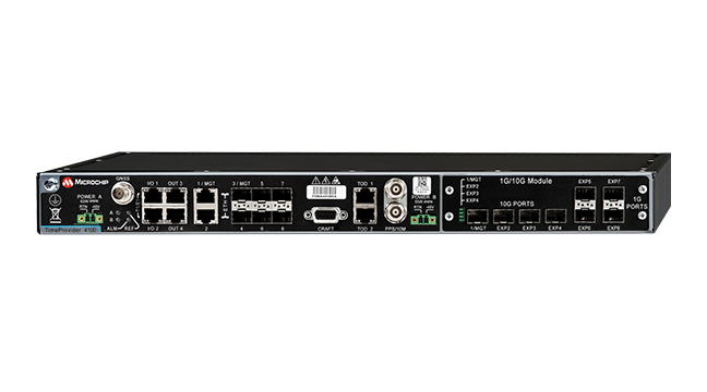
    Microchip Technology Inc.’s TimeProvider 4100 Release 2.2 grandmaster provides a new level of resiliency with the introduction of an innovative redundancy architecture in addition to support for a multi-band GNSS receiver and enhanced security to ensure always-on precise timing and synchronization.

    Redundancy is key for infrastructure providers to ensure uninterrupted services. Infrastructure deployments previously relied on hardware redundancy to avoid service disruption despite costly modular architectures. Microchip’s TimeProvider 4100 Release 2.2 grandmaster provides redundancy via software implementation, enabling flexible deployment and lower hardware costs without sacrificing ports.

    In addition, the TimeProvider 4100 Release 2.2 grandmaster introduces an increased level of resiliency by supporting a new GNSS multi-band, multi-constellation receiver to protect against time delay resulting from space weather, solar events and other disruptions that may impact critical infrastructure services.

    Multi-band GNSS is particularly important for the highest levels of accuracy, including primary reference time clock class B (PRTC-B, 40 ns) and enhanced primary reference time clock (ePRTC, 30 ns).

    With a focus on security solutions across its technology portfolio, Microchip’s new TimeProvider 4100 Release 2.2 grandmaster adds support for RADIUS and TACACS+ as well as new anti-jamming and anti-spoofing capabilities.

    “Resilient, redundant and secure precise timing and synchronization solutions are necessary to mitigate security risks to critical infrastructure,” said Randy Brudzinski, vice president and general manager of Microchip’s frequency and time business unit. “This latest release brings an innovative software redundancy that enables always-on technology as well as support for multi-band GNSS to eliminate ionospheric time error delays. It provides new key security, anti-jamming and anti-spoofing so critical infrastructure services can be accessed only by authorized, authenticated personnel.”

    In addition, the TimeProvider 4100 Release 2.2 grandmaster provides a super oven controlled crystal oscillator (OCXO) option for enhanced holdover capabilities in case of GNSS disruption.

    The TimeProvider 4100 Release 2.2 grandmaster is a family of products with hardware expansion modules for legacy fan-out or Ethernet fan-out with 10 Gigabit Ethernet support. It can be configured in specific operation modes to act either as a gateway clock, a high-performance boundary clock or an ePRTC.

    The TimeProvider 4100 Release 2.2 grandmaster embeds additional Microchip technology including its OCXO, super OCXO, rubidium atomic clock, field-programmable gate arrays (FPGAs), Ethernet switch, synthesizers and cleaning oscillators.

    The TimeProvider 4100 is part of Microchip’s Virtual Primary Reference Time Clock (vPRTC) product portfolio, offering end-to-end precise time and synchronization solutions. These include Cesium atomic clocks for source of frequency and time, the BlueSky GNSS Firewall for security, TimeProvider 4100 high-performance boundary clock and TimeProvider 4100 Gateway clocks, as well as the TimePictra software suite, which manages the end-to-end precise time architecture across all Microchip timing products.

    Microchip’s TimeProvider 4100 Release 2.2 grandmaster offers several options for software and hardware support including installation, sync audits, network engineering and 24/7 worldwide support. It is available now for both new and already-deployed systems.

  • Minutes posted for meeting on GPS documents

    Minutes posted for meeting on GPS documents

    The Air Force Space and Missile Systems Center has published minutes for the 2020 Public Interface Control Working Group (PICWG) and Open Public Forum help on Sept. 30, 2020, for the following NAVSTAR GPS public documents:

    • IS-GPS-200 (Navigation User Interfaces)
    • IS-GPS-705 (User Segment L5 Interfaces)
    • IS-GPS-800 (User Segment L1C Interface)
    • ICD-GPS-240 (NAVSTAR GPS Control Segment to User Support Community Interfaces).

    The meetings were held to update the public and collect issues and comments for analysis and possible integration into future GPS public document revisions, according to the U.S. Coast Guard Navigation Center (CGSIC).

  • Spirent doubles update rate of flagship GNSS simulator

    Spirent doubles update rate of flagship GNSS simulator

    Photo: Spirent
    Photo: Spirent

    Spirent Communications plc has added premium enhancements to its GSS9000 Series of GNSS constellation simulators.

    Among the enhancements, a doubling of the update rate means the GSS9000 series now offers the ability to recreate operations more precisely and realistically, reducing uncertainty in positioning, navigation and timing (PNT) testing.

    The latest developments provide the GSS9000 series with the ability to run simulations at a software and hardware update rate of up to 2 kHz, improving accuracy of the simulated trajectory without compromising performance. This is of particular benefit to high-dynamics applications, such as space missions and hypersonic vehicles. The increased update rate also delivers lower latency for hardware-in-the-loop (HIL) testing, further reinforcing the GSS9000’s position as the industry’s most accurate and realistic test instrument.

    “Our dedicated hardware and powerful software solutions are built specifically with PNT test in mind — to improve accuracy, increase flexibility and provide high-performing systems to meet customer needs,” said Adam Price, Spirent director of PNT simulation. “These latest enhancements to the GSS9000 continue to raise the bar for highly flexible and scalable solutions that enable our customers to stay ahead of their competition.”

    Other enhancements to the GSS9000 Series include:

    Extended Scenario Duration. In a simulation environment, where control and repeatability are key for a realistic representation of the mission, reducing the number of user inputs is essential. The new update will extend the available scenario duration to 65 days, using the same initial conditions for the simulation throughout the duration of testing to deliver uninterrupted high-performance simulation for longer.

    Enhanced Embedded Interference Capabilities. To provide greater power and flexibility in interference testing, Spirent has improved support for interference testing on wide spectrum signals, increased bandwidth resolution and repetition rates, and added variable bandwidth control on additive white Gaussian noise (AWGN).

    “Spirent’s leadership in GNSS testing comes from the combination of our unrivalled heritage and deep understanding of the PNT market, alongside our continuing commitment to improving test capabilities for customers,” said Ricardo Verdeguer Moreno, product line manager for high-end applications. “By working closely with customers, we are able to better understand the challenges they face, and these latest enhancements to the GSS9000 series demonstrate how we are continuing to help customers reduce uncertainty by providing more accurate operations, without impacting system performance.”

    The enhancements to the Spirent GSS9000 series will be available to new and existing customers at the beginning of the second quarter of this year. For more information, visit the GSS9000 Series product page. U.S. government and prime contractors should contact Spirent Federal for details.

  • How Galileo performed its authenticated positioning fix

    How Galileo performed its authenticated positioning fix

    News from the European Space Agency (ESA)

    In a first for any satellite navigation system, Galileo has achieved a positioning fix based on open-service navigation signals carrying authenticated data. Intended as a way to combat malicious spoofing of satnav signals, this authentication testing began at ESA’s Navigation Laboratory — the same site where the very first Galileo positioning fix took place back in 2013.

    These historic first authenticated signal position, velocity and timing fixes were made using a total of eight Galileo satellites for around two hours on Nov. 18. The tests represent a first proof of concept for an eventual operational service offering positioning with authenticated data to users.

    Spoofing has, for instance, been demonstrated as a means of forcing down drones or redirecting ships, while some high security locations — as well as disrupted international borders — have become notorious for spoofing signals that prevent the reliable use of satnav in their vicinity.


    The Galileo Control Centres send the navigation signal to the GSC for the addition of the authentication code, which is then returned for uplink to the satellites.


    “When a receiver picks up a navigation signal from a satellite, up until now it has no way of confirming that was indeed its source,” said navigation engineer Stefano Binda, overseeing the project for ESA. “This can result in spoofing — malicious people and organisations using false signals to mislead users about their actual position. This authentication service offers a way to prevent such deception.”

    “In recent years, this problem has become sufficiently pronounced as a weak point that the European Commission, ESA and European GNSS Agency (GSA) decided to develop signal authentication as a differentiator for Galileo,” Binda said.

    An ESA Navigation Directorate team at the Agency’s ESTEC technical centre in the Netherlands worked with its GSA counterparts at the twin Galileo Control Centres (GCCs) in Italy and Germany and the Galileo Service Centre (GSC) in Spain. “In everyday authentication you might send a document that has been digitally signed, where both sender and recipient use compatible cryptographic keys to validate the document’s source of origin,” Binda said.

    “In this case we were working with a constrained amount of bandwidth within the navigation signal, so instead opted for a ‘delayed key’ approach. This means the initial data come along together a short tag which, within a short stretch of time usually not exceeding 30 seconds, is followed by a key, which is able to validate the tag and authenticate the data associated with it.”

    During the test campaign, the Galileo Control Centres send the navigation signal to the GSC for the addition of the authentication code, which is then returned for uplink to the satellites, to be received and authenticated by the test receivers at ESTEC’s Navigation Lab and elsewhere in Europe, in participating laboratories.

    To enabled the authentication test campaign, Thales Alenia Space in France served as prime contractor to upgrade of the Galileo Mission Segment — the world-spanning system that determines and create the navigation messages broadcast by Galileo satellites. Thales Alenia Space in Italy was responsible for the system level integration.

    No modification of onboard satellite systems has been required to support Open Service Navigation Message Authentication (OSNMA), as spare bandwidth was made use of.

    “We used our standard laboratory Septentrio test user receivers with a software add-on,” Binda said. “The beauty of this approach is that receivers will be able to make use of the future authenticated service without needing any new hardware, only software updates — apart from additional measures that might be mandated for operation in practice.”

    ESA and GSA are continuing their authentication testing, with a view to introducing an operational Open Service Navigation Message Authentication service for users in the near future.

    ESA’s Radio Frequency Systems, Payload and Technology Laboratories perform RF research for both the space and ground segments. (Photo: ESA)
    ESA’s Radio Frequency Systems, Payload and Technology Laboratories perform RF research for both the space and ground segments. (Photo: ESA)
  • Spaceopal, GSA sign contract for Galileo High-Accuracy Service

    Spaceopal, GSA sign contract for Galileo High-Accuracy Service

    Spaceopal and the European GNSS Agency (GSA, the future EUSPA, the European Union Agency for the Space Programme) have signed a contract for the development of an innovative reference algorithm and user terminal for the Galileo High-Accuracy Service (HAS).

    Spaceopal is the prime contractor for Galileo’s operational services.

    Spaceopal is an equal-share joint venture between Telespazio, a Leonardo (67%) and Thales (33%) company, and DLR Gesellschaft für Raumfahrtanwendungen (GFR) mbH. Spaceopal will develop the solution with the support of its shareholders DLR-GfR and Telespazio, and partners such as ANavS GmbH, the DLR IKN, IABG mbH and Iguassu Software Systems.

    The project, awarded within the “Galileo Reference High Accuracy Service User Algorithm and User Terminal” Call, will develop the reference algorithm for HAS, which will be made publicly available and will be used for its validation. The user terminals at a high technology readiness level provided to GSA will serve as a blueprint and further facilitate the adoption of the European GNSS.

    Spaceopal will develop the solution in the next 12 months, followed by a 6-month period of providing engineering support to the GSA for testing activities, training and demonstrating the performance of Galileo HAS.

    Leveraging on the experience of the NAVCAST precise positioning services, on the commitment of Spaceopal’s shareholders and on the skills of its industrial partners, Spaceopal will build a close-to-market solution for the validation of the Galileo HAS service.

    “This contract is a substantial milestone in Spaceopal’s path to innovation excellence and confirms our commitment to support the GNSS services of the future. We are delighted to be trusted by the European GNSS Agency to develop this service further facilitating the adoption of the European GNSS, that will provide an unmatched accuracy for the HAS users,” said Sebastian Fedeli, Spaceopal’s sales and procurement director.


    Feature image: imaginima/iStock/Getty Images Plus/Getty Images

  • Hexagon releases machine-learning GIS tool for smart cities

    Hexagon releases machine-learning GIS tool for smart cities

    Hexagon’s Geospatial division has launched M.App Enterprise 2021, a significant update to its platform for creating geospatial and location intelligence applications. The latest release features new browser-based 3D capabilities and enhanced visual effects, plus the ability to create and configure custom applications more easily.

    M.App Enterprise 2021 adds complete and seamless integration with Hexagon’s LuciadRIA. Now, users can access LuciadRIA’s 3D features, including support for panoramic imagery, shading, ambient occlusion and other visualization effects, to build browser-based solutions with no development necessary.

    The latest version also features a new browser app configurator that makes it even easier to create spatio-temporal dashboards, known as Smart M.Apps. Additionally, Feature Analyzer has been expanded to allow users to add and manage multiple datasets on the fly and set up workflows. These enhancements enable more dynamic configurations, allowing field workers to be alerted quickly when action is required.

    The city of Klagenfurt, Austria — a long-time Hexagon customer — has already begun using M.App Enterprise 2021 to create a city app platform that features a detailed 3D urban landscape of the entire city.

    “This opens up endless possibilities for applications to automate several manual processes within different departments of the city,” said Günter Koren, head of the department of surveying and GIS at the city of Klagenfurt. “We believe M. App Enterprise will be an essential step in our journey to become a smarter, safer city for our 100,000 citizens.”

    The latest release contains other new features and improvements, including an overhauled style editor, a new default dark theme, options for customized theming and full support for SAP HANA databases.

    “M.App Enterprise 2021 helps organizations achieve smart monitoring of their cities, infrastructure and services by seamlessly incorporating location intelligence into enterprise systems and workflows,” said Georg Hammerer, chief technology officer of Hexagon’s Geospatial division. “With augmented visuals and dynamic configurations, this new version of M.App Enterprise can help customers easily set up powerful applications, allowing them to be more productive and efficient.”

    Screenshot: Hexagon Geospatial
    Screenshot: Hexagon Geospatial
  • Trimble introduces Siteworks SE Starter Edition for construction

    Trimble introduces Siteworks SE Starter Edition for construction

    The Trimble Siteworks SE Starter Edition. (Screenshot: Trimble)
    The Trimble Siteworks SE Starter Edition. (Screenshot: Trimble)

    Trimble has introduced the Trimble Siteworks SE Starter Edition, an entry-level construction surveying software program.

    With the program and a construction GNSS receiver, a supervisor, foreman, grade checker or site engineer can easily check a grade, slope or alignment and navigate the project more accurately and in less time than with traditional survey methods. It can also give more personnel on the jobsite access to survey technology, enabling more productive and efficient field crews.

    Trimble Siteworks SE Software is a simplified version of Trimble Siteworks Software, intended for users who do not require a full feature set and are interested in a lower-cost version to connect to GNSS only. The same colorful graphics, natural interactions and gestures, and self-discovery features found in Trimble Siteworks make the software easy to learn, so both experienced and new users can get up-to-speed quickly, Trimble said.

    Using the same data folder structure, file formats and workflows, Trimble Siteworks SE Software is fully compatible with Trimble Siteworks Software. Contractors can easily upgrade to the full version, making Siteworks SE an ideal entry point into construction technology for surveying.

    For contractors, Trimble Siteworks SE Software enables contractors to determine the location on a project, see cut/fill values to a design surface or alignment, or visualize constructible models in 3D. Users can measure feature (non-surface) points, lines and areas, or navigate to points, lines and alignments, and create PDF reports.

    In vehicle mode, users can capture high-accuracy measurements on steep slopes from a moving vehicle. Trimble Siteworks SE is compatible with a wide range of GNSS hardware configurations.

    Trimble Siteworks SE can share up-to-date information wirelessly between the field and the office to increase operational efficiency and reduce downtime.

  • Southwest Antennas releases rugged GPS/GLONASS antenna

    Southwest Antennas releases rugged GPS/GLONASS antenna

    Southwest Antennas has introduced a high-performance GPS and GLONASS active L1/L2 patch antenna for high-accuracy location service, timing and navigation applications.

    Part #1065-042 covers both the L1 and L2 bands, supporting military, commercial and industrial applications. For military users, the antenna supports the GPS P/Y code with +/-20-MHz bandwidth, allowing for increased accuracy, jam resistance and encryption for authorized military applications.

    Photo: Southwest Antennas
    Photo: Southwest Antennas

    The antenna’s built-in low-noise amplifier (LNA) and filters give it a total system active gain of +28 dB and out-of-band rejection of >50 dB (+50 MHz / -35 MHz of L1, +35 MHz / -45 MHz of L2). The specifications allow the antenna to operate in contested and congested radio frequency (RF) environments.

    “Our goal is to empower radio operators who require high-accuracy GNSS solutions with more choices for deployment and mounting,” said Benjamin Culver, president and co-owner of Southwest Antennas. “Adding onto our existing line of GPS antennas and gooseneck mounting options, users now have more freedom of choice in antenna placement to help overcome reception issues in challenging environments.”

    The low-profile radome allows the antenna to be easily tucked into pockets or modular lightweight load-carrying equipment (MOLLE) pouches and mounted on body armor, vests, rucksacks or other tactical gear. The custom black chrome SMA(f) RF connector ensures the antenna is waterproof, while allowing users to fully customize antenna placement on their gear and select their own cable type and length to suit their preference for mounting location away from their receiver.

    For additional flexibility in mounting locations, part #1065-042 features a magnetic mount integrated flush into the antenna’s radome, allowing it to be secured and removed quickly from any ferromagnetic surface. This extends the antenna’s operational capabilities through the ability to remotely locate the antenna away from the attached radio system to enhance satellite acquisition speed and signal strength when operating in environments with poor sky views.

    Applications include:

    • SAASM GPS, GLONASS, GNSS receivers, and other precision navigation receivers
    • Manpack and handheld radios, dismounted soldier-level communications
    • Small form-factor radios
    • Low-profile vehicle mounts and unmanned ground vehicles
    • Unattended/intelligent munitions systems
    • Aviators, combat search-and-rescue radios
    • IED recognition and destruction jamming systems
    • Law enforcement and first responders
    • Precision surveying receivers
    • Asset tracking
    • Precision timing applications
    • LBS and M2M applications
    • Oil and gas industries
  • KVH offers TACNAV 3D with photonic integrated chip technology

    KVH offers TACNAV 3D with photonic integrated chip technology

    KVH’s widely fielded tactical navigation system now upgraded with its patented PIC technology

    Photo: KVH Industries
    Photo: KVH Industries

    KVH Industries’ TACNAV 3D tactical navigation system is now available with the P-1775 inertial measurement unit (IMU) featuring KVH’s new photonic integrated chip (PIC) technology.

    KVH has been developing and testing the PIC technology for more than three years and is continuing to roll the technology into existing product lines.

    KVH’s PIC technology features an integrated planar optical chip that replaces individual fiber optic components to simplify production while maintaining or improving accuracy and performance. KVH’s IMUs with PIC technology are designed to deliver improved bias stability and 20 times higher accuracy than other micro-electromechanical systems (MEMS) IMUs.

    The fiber-optic gyro (FOG)-based TACNAV 3D tactical navigation system provides an assured positioning, navigation and timing (A-PNT) solution with an embedded GNSS and optional chip-scale atomic clock (CSAC). TACNAV 3D’s modular tactical design enables it to function as a standalone inertial navigation solution and as the core of an A-PNT-capable multi-functional battlefield management system.

    “We are pleased to incorporate our newest technology into the TACNAV 3D,” said Dan Conway, executive vice president of KVH’s inertial navigation group. “We are committed to ensuring that this battle-proven system provides the precise navigation that is vital to mission success and addresses the military demand for assured positioning, navigation, and timing (A-PNT) solutions.”

    KVH’s TACNAV solutions are being used in vehicles that operate in demanding environments, from battle tanks and M-ATVs, to armored vehicles, reconnaissance and combat support vehicles.

    Defense forces using TACNAV systems include the U.S. Army and Marine Corps, as well as many allied customers including Australia, Botswana, Brazil, Canada, Egypt, France, Germany, Great Britain, Italy, Malaysia, New Zealand, Poland, Romania, Saudi Arabia, Singapore, South Korea, Spain, Sweden, Switzerland, Taiwan and Turkey.

  • Septentrio receiver authenticates Galileo OSNMA signals

    Septentrio receiver authenticates Galileo OSNMA signals

    A Septentrio receiver has successfully authenticated navigation data of the first OSNMA encrypted GNSS satellite signal.

    OSNMA (Open Service Navigation Message Authentication) offers end-to-end authentication on a civilian signal, protecting receivers from spoofing attacks.

    OSNMA is being pioneered by the Galileo Program, with Septentrio providing a testbed for this technology from the end-user point of view. The anti-spoofing capabilities of OSNMA will complement Septentrio’s already available anti-jamming technology, AIM+, and further strengthen the overall security of Septentrio GNSS receivers.

    “The authentication of the Galileo signal using the OSNMA technology is yet another first that we are pleased to share with our close partner ESA [European Space Agency],” commented Bruno Bougard, R&D director at Septentrio. “Septentrio is proud and thankful to be able to contribute to the realization of one of Galileo’s key differentiators. “

    With OSNMA, Galileo is the first satellite system to introduce an anti-spoofing service directly on a civil GNSS signal.

    OSNMA is a free service on the Galileo E1 frequency. It enables authentication of the navigation data on Galileo and even GPS satellites. Such navigation data carries information about satellite location — if altered, it will result in wrong receiver positioning computation.

    While currently in development, OSNMA is planned to become publicly available in the near future. GPS is experimenting with satellite-based anti-spoofing for civil users with its Chimera authentication system.

    Within the scope of the FANTASTIC project led by GSA, OSNMA anti-spoofing protection was implemented on a Septentrio receiver.

    “Septentrio is committed to providing highly accurate and secure positioning and timing solutions to industrial applications and critical infrastructure. This is another example where Septentrio demonstrates its leadership in end-to-end GNSS receiver security with its breakthrough anti-jamming and anti-spoofing technology,” said François Freulon, head of Product Management at Septentrio. “Thanks to our future proof products, we will be rolling out OSNMA in our portfolio as soon as it is available. This will further enhance the security of our receivers, ensuring robust, trustworthy and reliable operation even in the most challenging environments.”

    Figure 3. European Galileo satellites provide an open authentication service on the E1 signal and a commercial authentication service on the E6 signal. (Image: European Space Agency)
    European Galileo satellites provide an open authentication service on the E1 signal and a commercial authentication service on the E6 signal. (Image: European Space Agency)

    ESA and GSA (European GNSS Agency) have now commenced the testing phase of the OSNMA authentication, which will continue during the coming months. To find out more about spoofing and OSNMA, see this article. For more information about GNSS signals and the value they bring, see Septentrio’s free webinar More GNSS signals: What’s in it for you?

  • Keep GPS Working Coalition supports upcoming FCC 5G vote

    Keep GPS Working Coalition supports upcoming FCC 5G vote

    Image: KENGKAT/iStock/Getty Images Plus/Getty Images
    Image: KENGKAT/iStock/Getty Images Plus/Getty Images

    Vote would make mid-band spectrum available for 5G

    The Keep GPS Working Coalition issued the following statement in support of an anticipated March 17 vote by U.S. Federal Communications Commission (FCC) commissioners that would make the 3.45–3.55 GHz band a contiguous block of “mid-band” spectrum, available for auction and deployment of high-speed wireless 5G networks.

    “The Keep GPS Working Coalition applauds the FCC for its consideration of this matter, which holds promise as a crucial step in the race to 5G and presents an opportunity for advancement without threatening the availability and reliability of GPS. We encourage the FCC to use this as an opportunity to showcase a bipartisan commitment to moving expeditiously to make this mid-band spectrum available for auction by early October.

    “The Department of Defense has also demonstrated its sustained commitment to advance the deployment of 5G services. We are grateful to the DoD for its leadership and cooperation with the FCC to make spectrum available for commercial use where it can while protecting national defense interests.

    “The spectrum being considered for auction is internationally harmonized and can be used nearly everywhere in the continental United States to the benefit of the entire country, including Keep GPS Working Coalition members. Importantly, it will advance this critical priority without the risk of harmful interference to GPS currently posed by Ligado Networks, proving that 5G and GPS can coexist.”

  • First Fix: Hunters and gatherers

    First Fix: Hunters and gatherers

    While farmers work on growing and gathering their crops in the most efficient ways possible, other people key to the agriculture industry are hunters. These hunters seek the most efficient and groundbreaking ways to carry out such tasks as plowing, planting, fertilizing, weeding and, finally, gathering.

    This month, among other machine-control applications, we focus on using GNSS technology to improve agricultural efficiency. According to research firm MarketsandMarkets, the precision farming market is estimated to be $7 billion in 2020 and is projected to reach $12.8 billion by 2025, growing 12.7% every year between.

    Factors driving growth include increasing farm mechanization in developing countries, rising labor costs, increasing strain on the global food supply, substantial cost savings associated with smart farming techniques, and government initiatives to adopt modern agricultural techniques. For a look at today’s technology, see our cover story.

    James Litton
    James Litton

    Sadly, this month we also say goodbye to a pioneer in the precision ag field. James D. Litton founded NavCom Technology in 1995 with three partners, Ron Hatch, KT Woo and Jalal Alisobhani.

    Litton’s career began at Magnavox in the early days of GPS, where he worked on the original proposal for GPS Phase I and helped develop new and advanced commercial navigation and survey receivers for both the Navy’s TRANSIT system and the Air Force’s GPS.

    In 1992, Litton opened a consulting firm, and in 1994, he and his partners founded NavCom with Litton as CEO. Under contract, NavCom developed a single-frequency WAAS-capable GPS aircraft navigation receiver.


    “His work transformed agriculture into a data-driven, technological industry.” — Brad Parkinson


    NavCom also began a relationship with Deere & Company, supporting more efficient and productive agriculture. This relationship was so successful that Deere, which recognized GNSS tech as a smart investment, purchased NavCom in 1999.

    Litton continued to lead the company and serve as part of Deere’s senior management team for eight more years.

    Among his many contributions to the GNSS field, his impact on global agriculture might well have been his greatest, according to Brad Parkinson, the original chief architect for GPS and Editorial Advisory Board member.

    “His work transformed agriculture into a data-driven, technological industry that was incredibly more efficient,” Parkinson said. “The cost savings and increases in productivity have impacted billions around the world.”

    Litton also authored several articles for GPS World.

    He died in January at his home in California with his family at his side. He was 89 years old. His family asks that donations in his name be sent to doctorswithoutborders.org.