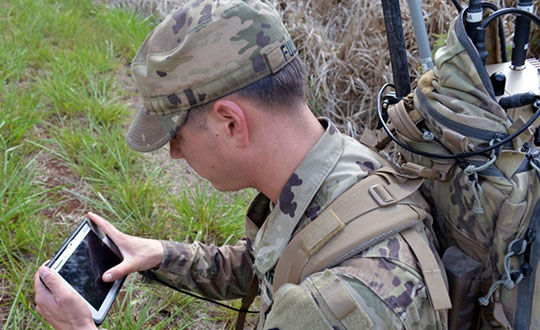
Galileo PRS encrypted signal integrated for first time
Orolia, through its France-based entity Orolia Systèmes & Solutions (O2S), has been selected for the GEODE project to develop European standardized and sovereign Galileo PRS positioning, navigation and timing (PNT) receiver capabilities for military applications.
The GEODE (Galileo for EU Defence) program aims at promoting the competitiveness and innovation of the Defense PNT industry in the European Union.
The GEODE consortium will support the prototyping, testing and qualifying of military PNT technologies and resources such as PRS security modules, PRS receivers, GPS/Galileo PRS compatible Controlled Radiation Pattern Antennas (CRPA), and the development of a European PNT test and qualification facility.
As part of this consortium, Orolia brings its proven track record of developing Galileo-based applications and integrating custom signals for commercial and defense critical infrastructure in the GEARS program, and will now focus on the military use of the PRS signal by leading the critical timing and synchronization applications in the GEODE program.
This new PRS support and qualification infrastructure will ensure that the necessary security resources are in place for operational testing, and PNT testing profiles will be defined for naval, land and remotely piloted aircraft platforms.
The applications targeted for these new technologies and capabilities include tactical drones, military satellite and space technologies, unmanned ground vehicles, high precision missile systems, next-gen naval platforms, airborne electronic warfare solutions, resilient networks, cyber situational awareness, and the latest active stealth technologies.
This project will receive about €44M funding from the European Defence Industrial Development Programme (EDIDP) under grant agreement No EDIDP-PNTSCC-2019-039-GEODE.
“We are proud to support the development of future resilient military technologies that will increase safety and security in the European Union,” said Orolia CEO Jean-Yves Courtois. “As the world leader in resilient PNT, Orolia is uniquely positioned to offer the most advanced technologies for timing, synchronization, and GNSS testing and simulation, including encrypted GPS and Galileo signals.”
Orolia Systèmes et Solutions (O2S). In 2019, Orolia launched Orolia Systèmes and Solutions (O2S), a France-based entity dedicated to providing advanced resilient Positioning, Navigation and Timing (PNT) solutions and custom engineering services to French and EU Defense organizations.
The GPS Innovation Alliance (GPSIA) sent a letter on Feb. 16 to the White House National Economic Council, asking it solve the issues with Ligado interfering with GPS spectrum.
“Strong and unified leadership by the U.S. government is needed to preserve and advance GPS — leadership that recognizes the inherently unique functional and technical attributes of GPS,” wrote J. David Grossman, GPSIA executive director, in the letter.
Panel on risks to sat services
GPSIA’s J. David Grossman will be speaking Feb. 17 at 2 p.m. ET, in a panel discussion entitled “Satellite-Based Services at Risk?” Other speakers include former FCC Commissioner Robert McDowell; Capt. Steve Jangelis, representing the Air Line Pilots Association (ALPA); and Susan Avery, former president of the Woods Hole Oceanographic Institution. Register here.
The coalition, which counts Garmin, Apple and John Deere among its members, was ensnared in the dispute between Trump executive branch agencies and the Federal Communications Commission (FCC) over whether the commission’s Ligado approval decision in 2020 would affect GPS.
In the letter to NEC Director Brian Deese, the group argues that these squabbles “are not unique to GPS” and “reflect a continued pattern by which shared decision-making is replaced by the FCC acting with exclusive authority as the final arbiter.”
GPSIA recommends that the council
update a memorandum of understanding between the FCC and Commerce Department to help ease decision-making;
install a detailee from federal agencies managing GPS in the FCC’s engineering office; and
have each FCC commissioner add a technical adviser to its staff.
The letter concludes, “GPSIA and its members stand ready to be a resource to the NEC and others in the Administration seeking to more efficiently allocate spectrum, while protecting critical incumbent systems and services.”
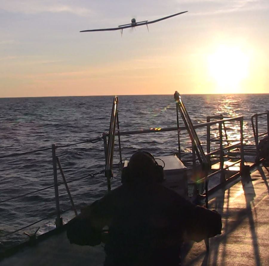
French ministry for Armed Forces selects Airbus Survey Copter Aliaca fixed-wing drone systems to equip its ships
Airbus Defence and Space mini UAS subsidiary Survey Copter signed a contract with French DGA Armament general directorate to provide the French Navy with 11 systems, (22 aircraft), of the electrically powered fixed-wing Aliaca maritime version UAS (officially called SMDM / “Systèmes de Mini Drones aériens embarqués pour la Marine” by French authorities), including training and integrated logistic support. First deliveries are expected in 2021.
“We are honored to contribute to the missions of the French Navy which we will support with the highest standards of quality and reliability,” said Nicolas Askamp, head of Survey Copter/Airbus Unmanned Aerial Systems. “This new contract strengthens Survey Copter’s position as a global key player for maritime mini UAS.”
The Aliaca maritime UAS is a high-endurance versatile system allowing up to 3 hours missions over a 50 km (27 Nm) range, perfectly adapted to maritime missions with high gyro stabilized EO/IR payload performances and qualified to operate in severe environmental conditions.
The Aliaca SMDM is catapulted from a ship deck. (Photo: Airbus Defence and Space)
Launched by catapult, the Aliaca maritime UAS concludes its flight by landing automatically using a dedicated net landing solution. With a length of 2,2m and a wingspan of 3,6m for a maximum take-off weight of 16 kg., the Aliaca maritime UAS benefits from a powerful yet silent electric motor. The system can be deployed easily and rapidly in less than 15 minutes by 2 operators only.
Similarly, the user-friendly ground control station enables the operator to constantly monitor the automatic flight of the UAS while receiving in real-time day and night images and AIS (Automatic Identification System) data gathered by its on-board sensors.
It is designed to conduct several types of missions around the ships, including increasing the understanding of the tactical situation, control of illegal operations at sea, search-and-rescue, traffic monitoring, pollution detection, tracking of any suspicious behavior in the ship environment and coastal surveillance.
This light on-board aerial solution gives the opportunity to vessels, traditionally not equipped with aerial assets, to enhance their tactical ISR capabilities, support decision making and reactivity in operations.
The Aliaca maritime UAS can easily be integrated on board any ships, with or without helicopter landing-deck, and its small logistic footprint enables operations and storage on board smaller sized ships. Its integration does not require heavy on-board modification nor storage of specific fuel.
The result of 10 years of R&D investments and on-board experimentations, SURVEY Copter’s off-the-shelf Aliaca maritime UAS is a robust and resistant system to the corrosive maritime environment, an adapted solution to the electromagnetic constraints on board, and benefits from an efficient net recovery system, fully automated, meaning that no human action is required during the recovery phase.
Raytheon Intelligence & Space, a Raytheon Technologies business, delivered its 3,000th MAGR 2000-S24 GPS system to the U.S. Air Force. The MAGR2K is a secure, resilient GPS receiver that allows the warfighter to navigate the battlespace with protection against interference and jamming.
The MAGR2K is an upgrade to the legacy miniaturized airborne GPS receivers and is in service aboard 20 types of fixed-wing and rotary-wing platforms from Department of Defense and Foreign Military Sales customers.
“In the battlespace, disruptions to navigation are not an option,” said Eric Ditmars, vice president of Secure Sensor Solutions at RI&S. “Our MAGR2K GPS receivers enhance GPS acquisition and performance ensuring military forces reliable and assured GPS data they can act on. Delivery of the 3,000th unit is a significant milestone for our team.”
Raytheon Intelligence & Space continues to upgrade the MAGR2K technology to stay current with the evolving battlespace. Development is underway for the MAGR-2K-M, which uses the company’s M-code technology.
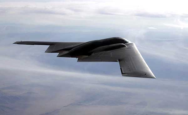
The first production readiness units are undergoing platform integration on the U.S. Air Force’s B-2 platform.
B-2 Spirit multi-role bomber capable of delivering both conventional and nuclear munitions. In December 2017, the Air Force completed a series of successful flight tests of M-code GPS using a Raytheon Company receiver on board a B-2 Spirit at Edwards Air Force Base, California. (Photo: U.S. Air Force/Bobby Garcia)
A new GNSS architecture aboard low-Earth-orbit (LEO) satellites is in development.
The patent-pending system architecture “is combining the efficiency and innovation of the new space era with the world of satellite navigation to help enable modern intelligent systems to operate safely in any conditions, anywhere on the planet,” according to a press release from Xona Space Systems.
Xona, a San Mateo-based startup, announced a service agreement to advance its 2022 Alpha mission. The agreement is with Momentus Inc., a commercial space company offering in-space infrastructure services.
Once complete, Xona’s LEO smallsat constellation will provide a resilient alternative to GNSS with more than 10 times better accuracy, Xona claimed.
“Xona is developing a truly innovative system to enhance the reliability and precision of global PNT and GNSS. As an infrastructure company, Momentus is excited to partner with other like-minded pioneers to help build out the future services needed to enable human presence in space while improving life on earth,” said Dawn Harms, Momentus CEO.
“We have been very impressed with the capabilities and services that Momentus offers with their Vigoride spacecraft,” said Xona CEO Brian Manning. “There is a rapidly growing demand for higher performance navigation and timing services as well as alternatives to GNSS. Forming this partnership with Momentus represents a key milestone in our technology development roadmap as we work towards our on-orbit demonstration and deployment of the full constellation to meet these needs.”
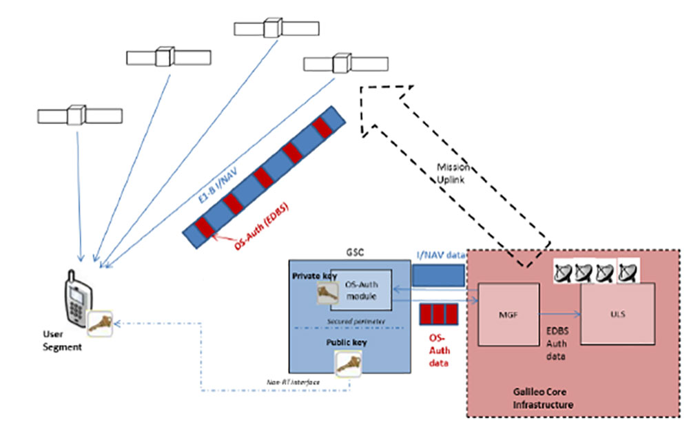
In a first for any satellite navigation system, Galileo has achieved the first position fix based on navigation signals carrying authenticated data, according to the European Space Agency.
Galileo’s Open Service Navigation Message Authentication (OSNMA) is intended as a way to combat malicious spoofing of satnav signals.
OSNMA receivers successfully calculated an OSNMA-protected position fix after Galileo satellites started transmitting authentication data at 15:28 UTC on Nov. 18, 2020. The first tests used eight Galileo satellites for around two hours on Nov. 18. Tests have continued ever since, for intermittent periods, and will continue over the next months ahead of a public observation phase.
The first authenticated signal position, velocity and timing fixes were made using a total of eight Galileo satellites for around two hours on Nov. 18, 2020. The tests represent a first proof-of-concept for an eventual operational service offering positioning with authenticated data to users. (Image: ESA)
Pioneering a long-awaited service
The Galileo OSNMA authentication mechanism allows GNSS receivers to verify Galileo information, making sure that received data are indeed from Galileo and not modified in any way.
“Ensuring the validity of positions elaborated by GNSS is one of the main challenges before addressing an entirely new set of applications demanding dependability and resilience,” said Matthias Petschke, director of space at the European Commission, DG DEFIS. “Galileo is now set on course to deliver on this highly anticipated feature and has many more novel features in store for the coming years.”
Testing is taking place at ESA’s Navigation Laboratory at ESTEC in the Netherlands, the same site where the first Galileo positioning fix took place in 2013.(Photo: ESA)
Increased robustness
OSNMA test signals are being broadcast by the Galileo constellation using the spare bits from the current navigation message, therefore not impacting the legacy OS receivers implementing the current OS Signal-In-Space Interface Control Document (OS SIS ICD).
“Galileo’s Open Service Navigation Message Authentication is one of its key differentiators,” said Rodrigo da Costa, executive director of the European GNSS Agency. “The additional robustness that it will provide to the Galileo signal will be critical for many applications, particularly those where security and trustworthiness are a priority, making the OSNMA a key component in any resilient PNT solution.”
OSNMA works on a comparable basis to everyday encryption, where sending a digitally signed document involves both sender and recipient using compatible cryptographic keys (private and public) to validate the document’s source of origin.
“Up until now, as a navigation satellite disseminates navigation and timing data, there is no way of confirming these data are indeed coming from their apparent originator,” explained Paul Verhoef, director of navigation at the European Space Agency. “As a result, the data could be falsified, a phenomenon known as spoofing, where corrupt false signals mislead receivers about their position, misleading their users in turn, with potentially serious consequences.”
An ESA Navigation Directorate team at the ESTEC technical centre in the Netherlands worked with their European GNSS Agency (GSA) counterparts at the twin Galileo Control Centres in Italy and Germany and the Galileo Service Centre (GSC) in Spain to develop and test the OSNMA.
Next steps
Upon successful completion of the internal testing phase, a public observation phase will begin, in which the OSNMA signal will be publicly accessible. In preparation for this phase, the OSNMA user Signal-In-Space Interface Control Document (OSNMA SIS ICD), receiver implementation guidelines, and the necessary cryptographic materials will be published. This will allow receiver manufacturers and application developers to test and prepare their products.
During the public observation phase, feedback will be gathered from users, leading to the consolidation of the service.
Testbed vehicle by ESA’s Navigation Lab. (Photo: ESA)
A roundup of recent products in the GNSS and inertial positioning industry from the February 2021 issue of GPS World magazine.
OEM
Development kit
Allows engineers to evaluate GNSS/INS module
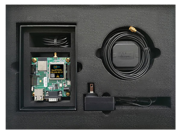
Photo: Aceinna
The Aceinna OpenRTK330LI EVK is a complete evaluation and development kit for the OpenRTK330LI GNSS/INS module. The kit accelerates development and reduces time to market of custom navigation and guidance systems fusing inertial measurements and multi-band RTK/GNSS positioning. It provides the essential hardware, firmware and development environment that engineers working on autonomous applications need to quickly start developing algorithms and solutions, allowing engineers to log and visualize positioning data with centimeter precision.
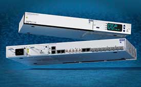
The OSA 5412 and 5422 are edge and access network synchronization devices with enhanced capabilities for next-generation applications such as 5G. The Oscilloquartz solutions address key challenges for a wide range of industries by bringing new levels of timing accuracy and resilience to edge networks. Both models provide in-service sync probing and assurance as well as innovative GNSS assurance capabilities. The devices also eight field-upgradeable, 10-gigabits-per-second ports, ensuring the scale and efficiency needed for next-generation smart grids, industrial internet of things (IoT) applications and 5G connectivity.
The AirgainConnect AC-HPUE 6-in-1 is a rugged outdoor mobile antenna with integrated modem, designed to meet the most demanding LTE connectivity needs of public safety and fleet vehicles. AC-HPUE provides two or three high-gain multi-band LTE antennas and one-band 14 LTE antenna powered by an HPUE LTE modem. The AC-HPUE supports an active GNSS element as well as two or three high-gain tri-band Wi-Fi antennas, including the new 6 GHz ISM band for Wi-Fi 6E (802.11ax), inside a single robust and compact housing. AC-HPUE attaches to the router WAN port via Ethernet data cable or directly to a laptop via USB cable. Wi-Fi and GNSS antennas connect to the router, meaning the router can be seamlessly used for Wi-Fi, location-based services, and managed using existing network management systems.
Amazon Monitron provides customers with an end-to-end machine monitoring solution comprised of sensors, gateway and machine learning service to detect abnormal equipment conditions that may require maintenance. Monitron is one of five new machine learning services that help industrial and manufacturing customers embed intelligence in their production processes to improve operational efficiency, quality control, security and workplace safety. The services combine sophisticated machine learning, sensor analysis and computer vision capabilities to address technical challenges faced by industrial customers. The other four services are Amazon Lookout for Equipment, the AWS Panorama Appliance, the AWS Panorama SDK and Amazon Lookout for Vision.
Carlson Layout allows fast, efficient layout capabilities for construction professionals using total stations or GPS receivers such as the Carlson CR+ series of robotic total stations and the Carlson BRx7 GNSS receiver. Included are the full Carlson driver library and a range of compatible hardware options. Features include an intuitive user experience, support for DXF and DWG files, integration with Google Drive and other cloud storage, compatibility with Carlson CRD and CRDB files, and the ability to check surface or fixed elevations without creating points. It also includes simple layout for points, lines and surfaces. Layout works with GPS real-time kinematic (RTK) systems and can receive RTK connections from a cellphone, internal modem, internal radio or external radio.
Surfer is a gridding, contouring and 3D surface-mapping package. The latest version offers a greater number of options for displaying scientific data. New display options enable users to more easily communicate the information extracted from their data. The Surfer package is used by professionals in oil and gas exploration, environmental consulting, mining, engineering and geospatial projects to easily visualize and interpret complex data sets. Surfer enables users to model data sets, apply an array of advanced analytics tools, and graphically communicate the results. Features include a new peaks and depressions layer type for mapping geohazards or drainage patterns in karst topographies.
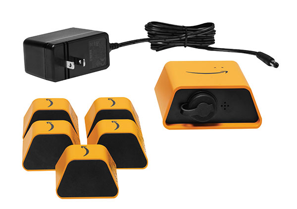
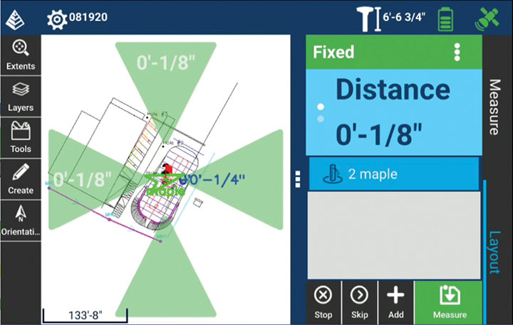
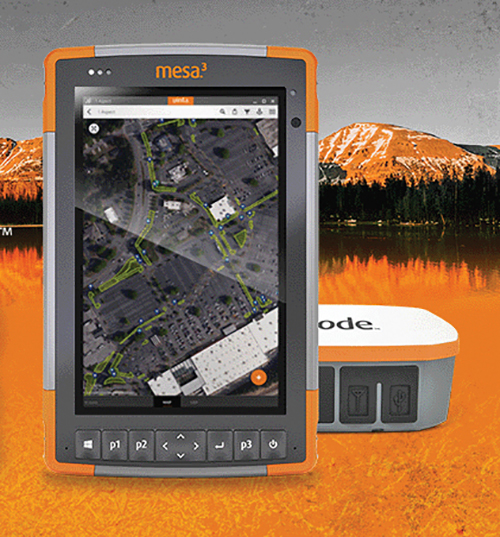
Uinta’s data collection tools include detailed mapping with points, lines, areas and form-based notes for digital recordkeeping. Customization options allow organizations to create templates that better align with the type of data they are mapping and recording. Templates can be shared among users, and Juniper Systems has many templates for various industries and use cases. Users can export data to a file, print professional PDF map reports, and create optional cloud projects. Combined with a Mesa 3 Rugged Tablet running Windows 10 and a Geode Sub-meter GPS Receiver, Uinta offers a rugged, robust and powerful data collection solution. Industries using Uinta include utility mapping, government asset management and mapping, industrial assets, irrigation, and sectors within natural resources.
The FLY-R R2-150 has a top speed of 200 km/h (124 mph). Currently in functioning prototype form, the battery-powered R2-150 is designed for such tasks as fully autonomous surveillance, observation and reconnaissance. It has a wingspan of 1.5 meters (4.9 feet), a cruising speed of 115 km/h (71 mph), and can fly for up to two hours per charge while transmitting real-time video. It can automatically take off from a ship- or truck-mounted vacuum launcher and land in a recovery net. Another model, the jet-powered R2-HSTD, is expected to have a top speed of Mach 0.65 (803 km/h or 499 mph) and is intended to serve as a target drone for military exercises. FLY-R’s aircraft incorporate a rhomboidal wing design, which reduces wingspan by half and reduces aerodynamic drag.
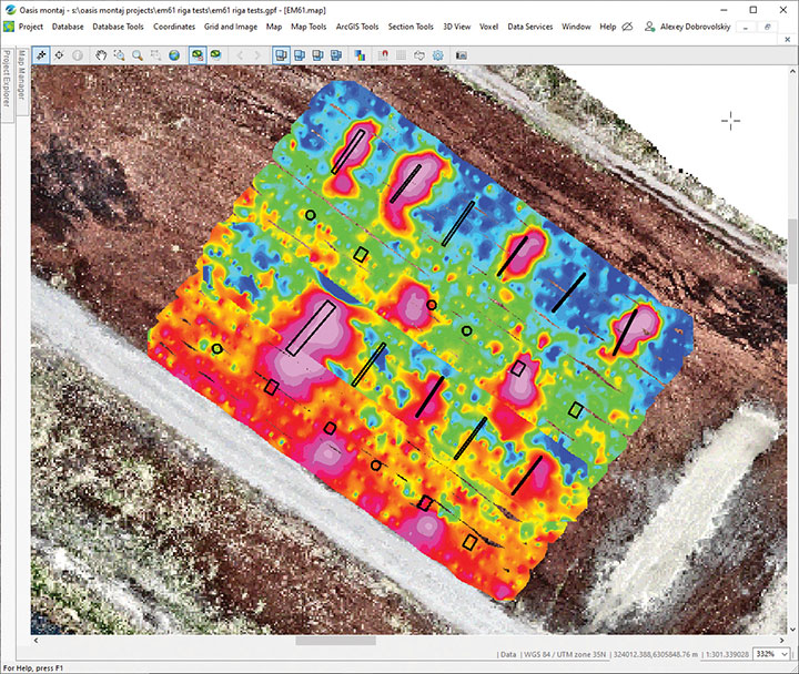
The drone-integrated metal detection system uses an airborne modification of the Geonics EM61-MK2 ground metal detector. The EM61 Lite airborne variant integrates with the UgCS SkyHub onboard computer and ground control station. Features include automatic data logging in geotagged form and automatic terrain following with radar altimeter. The use of UgCS SkyHub enables the drone to fly in true terrain following mode with the help of the radar altimeter and to log geotagged sensor data. An optional RTK/PPK GNSS receiver on the drone will geotag the data with centimeter-level precision. The integrated system has been extensively tested at SPH Engineering’s test range, and has shown excellent performance and repeatability for targets such as pipes (steel, stainless steel, reinforced concrete) and steel drums. Applications include unexploded ordnance (UXO) search, detection of underground infrastructure and archaeology.
A crucial step toward the development of the Galileo Public Regulated Service (PRS) military user segment took place Monday, Feb. 8, with the kick-off meeting in Brussels of the GEODE (GalilEO for EU DEfence) project, according to a press release from FDC.
GEODE is the biggest Galileo application development project ever launched.
Sponsored by Belgium, Germany, Italy, France and Spain — contributions should exceed 82.7 million euros — GEODE is supported by the EU with a grant of about 44 million euros. The ambitious defence-cooperation project is under the umbrella of the European Defence Industrial Development Programme (EDIDP) of the European Commission.
GEODE will establish the framework for developing the Galileo PRS user segment for defense applications. At kick-off, the project involved 30 companies and organizations from 14 EU Member States: Belgium, Czech Republic, Estonia, Finland, France, Germany, Greece, Italy, the Netherlands, Poland, Portugal, Spain, Sweden and Romania.
The GEODE Roadmap
National defense organizations — in close cooperation with industry — have defined a roadmap for the Galileo PRS military user segment development, beginning with a specification and standardization phase. GEODE will prototype, test and qualify
seven PRS security modules developed from various technologies
nine PRS receivers (including two server-based variants)
four GPS/Galileo PRS-compatible anti-jamming controlled radiation pattern antennas (CRPA).
A common and standardized test environment will be developed as well as a PRS infrastructure to ensure the availability of the security assets for operational testing.
Finally, military operational field testing will be organized on military platforms (naval, land and drones) and timing and synchronization systems in (at least) Belgium, Czech Republic, France, Germany, Greece and Romania.
A PRS solution for spacecraft will also be designed and prototyped.
Beyond paving the way for the equipment of EU Member States defense forces with Galileo PRS, the military user segment that is developed, tested and certified under GEODE is planned to be available for export to other countries that have the necessary PRS security agreements with the EU.
The GEODE project will be completed in 2026.
Plans are for GEODE to
boost EU competitiveness in the highly strategic domain of military positioning, timing and synchronization.
foster the equipment of EU Member States’ military forces with Galileo PRS capability, essential to reinforce their interoperability and autonomy.
facilitate access to complex security-certified technologies and make them affordable through means of standardization and by creating the necessary critical mass.
In brief, the project will bolster EU Member States’ military capability, create business opportunities for the EU industry in the field of military application of satellite navigation, and maximize the benefits of the Galileo programme by energizing the adoption of its PRS service in all EU Member States and beyond.
Background on GEODE
This project has received funding from the European Defence Industrial Development Programme (EDIDP) under grant agreement No 039.
The GEODE industrial consortium is led by FDC and comprises the major industry players of the field: Airbus Defence and Space, Antwerp Space, Cy4gate, Diehl Defence, Elettronica, Fraunhofer Institute for Integrated Circuits IIS, GMV Aerospace and Defense, Indra Sistemas, Safran Electronics and Defense, Leonardo, Siemens Aktiengesellshaft, Orolia, Tecnobit, Telespazio, Thales Alenia Space Italia, Thales AVS France, Thales SIX GTS France, accompanied with 12 other EU companies acting as subcontractors (c.f. picture hereafter).
The GEODE project is developed in the context of the European Radio-navigation Solution (EURAS) project of the Permanent Structure Cooperation (PESCO). The EURAS project aims at promoting the development of EU military positioning, navigation and timing) capabilities and future cooperation taking advantage of Galileo and the PRS.
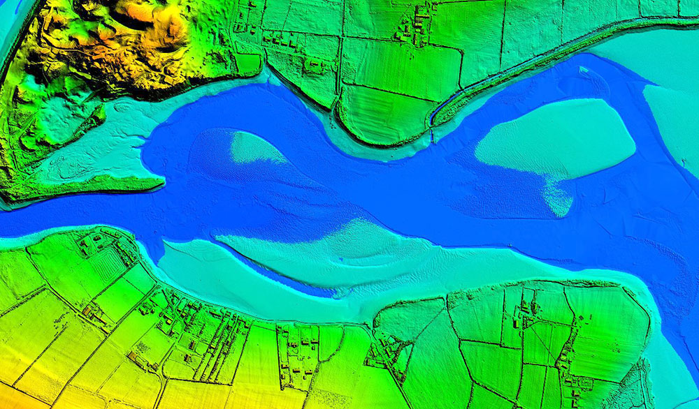
Dundrum Bay on the coast of Northern Ireland is captured by a mapping airplane in a project to document climate change effects. (Photo: DAERA/Bluesky)
Bluesky International will use aircraft-mounted lidar sensors and laser scanners to create a highly detailed 3D map of the whole of the Northern Ireland coastline.
Working on behalf of the Department of Agriculture, Environment and Rural Affairs (DAERA), the lidar survey will be used to create the first complete baseline. The baseline will underpin recording of coastal change and help identify the rate at which the coastline is changing as a result of climate change.
In addition to the lidar data Bluesky will simultaneously capture high detailed aerial photography which will be processed to produce to a fully orthorectified, 10-centimeter-resolution database.
The Bluesky data will form part of the wider Northern Ireland 3-dimensional coastal survey. The survey will extending into the marine environment with a satellite-derived bathymetric survey and a pilot bathymetric lidar survey. Together, the surveys will inform the development of future coastal management policies.
“The Northern Ireland coast is a hugely valuable resource which is currently facing increasing pressure from climate change,” said Joanne Hanna, senior scientific officer within the Marine and Fisheries Division of DAERA. “Sea-level rise, in combination with an increase in extreme storm events, is resulting in greater energy impacting our coastlines, altering coastal processes and accelerating change.
“Despite the importance and the value of this coastline, the nature and scale of the issues arising from coastal change and sea-level rise are currently not known and there is limited and insufficient baseline data available,” Hanna said. “The coastal lidar survey carried out by Bluesky will provide scientifically robust baseline data which will enable decision makers and coastal managers to make informed decisions and devise solutions and appropriate management to the problems currently facing our coastline.”
Bluesky will undertake the specialist survey using a fixed wing manned aircraft and will fly the 763 kilometres of Northern Ireland coastline capturing height measurements of both the underlying terrain and any surface features at a resolution of better than 16 points per metre. This data will be used to create highly accurate 3D digital terrain and surface models (DTM, DSM) with a spacing of up 25 centimetres.
The Bluesky datasets will be supplied ready for use in a range of geographical information system (GIS), desktop mapping and other specialist software packages and will be compatible with other DAERA datasets including Ordnance Survey mapping.
“Seen & Heard” is a monthly feature of GPS World magazine, traveling the world to capture interesting and unusual news stories involving the GNSS/PNT industry.
The city of Prague started testing a system of GNSS repeaters to prevent the loss of satellite signal in the city’s tunnels. The system, which should make life easier for drivers who rely on car navigation technology, is being tested in Prague’s Blanka tunnel. If it proves successful, the municipality wants to install the devices in other strategic locations around the city, especially at intersections as well as tunnel entries and exits.
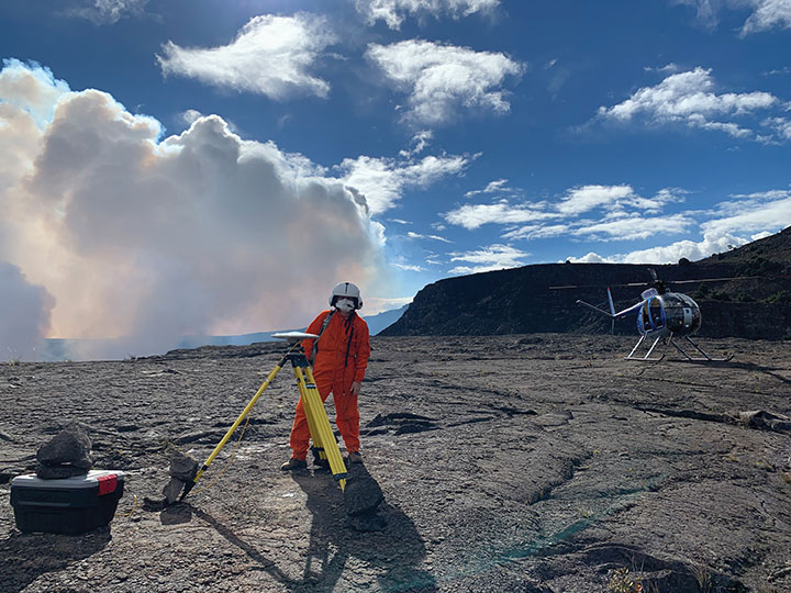
Photo: A. Ellis/USGS
On the hot spot
While permanent monitoring receivers are scattered about Hawaii’s active volcano sites, additional GPS receivers are being deployed during the ongoing eruption of Kilauea. In this photo taken Dec. 21, 2020, a Hawaiian Volcano Observatory geophysicist deploys receivers on the caldera floor in Hawai‘i Volcanoes National Park to measure changes in ground motion. The gas plume from the summit eruption within Halema‘uma‘u crater is visible in the background.
Photo: Ishaqbini Community Conservancy
Last but not least
The last white giraffe known in existence now sports a GPS tracker, reports BBC News. The male giraffe has a rare genetic trait called leucism that causes the unusual color. The giraffe was tranquilized in November and the tracker placed on one of its horns. Tracking will help protect it from poachers as it grazes in Kenya’s savannah near the Somalia border. The white giraffe is alone after a female and her calf were killed by poachers in March 2020, according to Ishaqbini Hirola Community Conservancy.
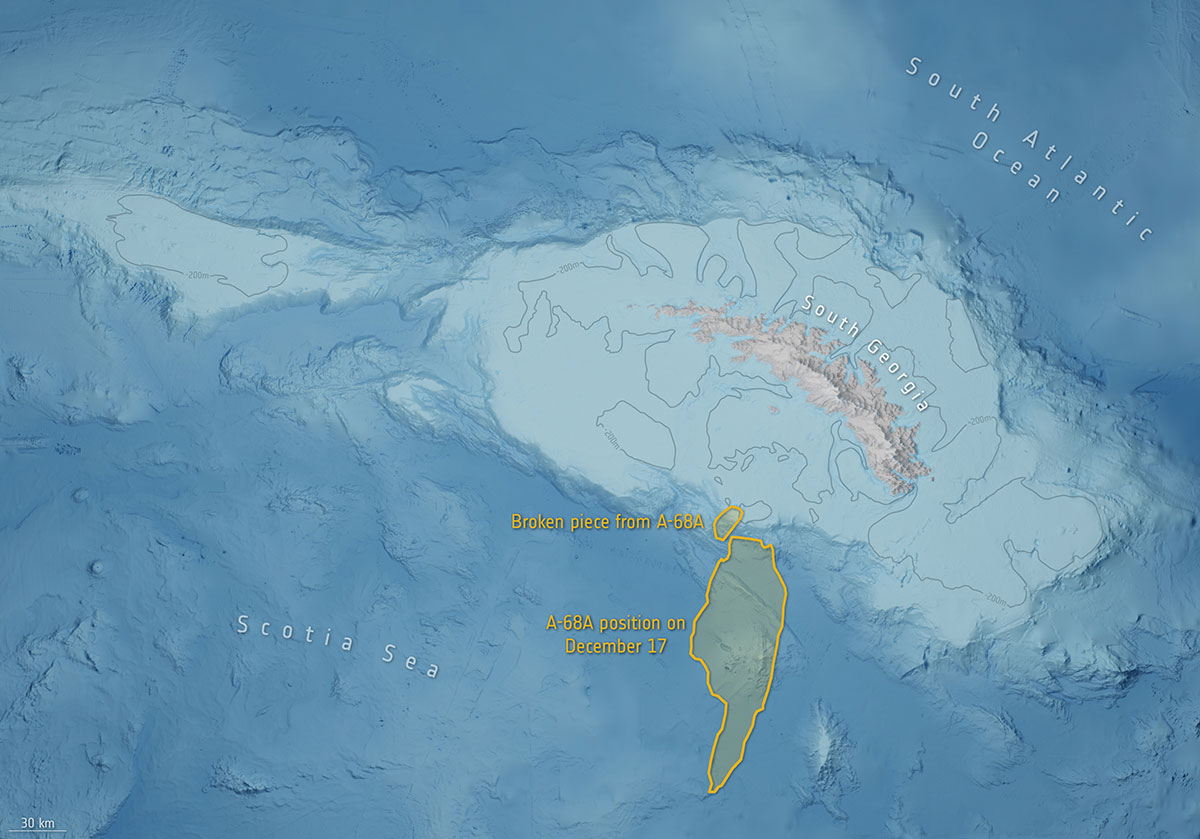
Photo: British Antarctic Survey/ESA
The biggest loser
In July 2017, an iceberg more than twice the size of Luxembourg broke off Antarctica’s Larsen C ice shelf and began traveling the Southern Ocean. Looming in its path is South Georgia Island, home to numerous species of wildlife threatened by the massive iceberg, designated A-68A. Europe’s Copernicus Sentinel satellites observed pieces breaking off of A-68A in December, each large enough to receive its own designation.
2,300-acre Shell Deer Park Refinery provides complex testbed for aerial inspections and incident response
Photo: SimonSkafar/E+/Getty Images
DJI is partnering with Shell Oil Company to create, test and deploy DJI drone technology at its Deer Park Manufacturing Complex to improve efficiency and worker safety during industrial inspections and emergency incident response.
The Shell Deer Park drone team adopted DJI drones in 2016 to reduce the need to work at height while improving safety and cutting the cost of inspections in the process. As a Solution Development Partner, Shell will work with DJI to develop and test advanced drone solutions, like the DJI Matrice 300 RTK, that allow workers to automate required inspections of critical infrastructure like flare tips and floating roof tanks whose condition and activity are difficult to assess from ground level.
“As one of the world’s largest energy companies, Shell has provided us with valuable insight into the unique challenges of conducting aerial inspections at one of its largest facilities where infrastructure exceeds the height of 250 feet off the ground,” said Cynthia Huang, until recently the director of business development at DJI. “Through our collaboration, DJI will receive valuable first-hand insight into the complexities of deploying drone technology at a world-class refinery, and co-develop new product features like AI Spot-Check that will allow Shell and other innovative energy companies to use drones to safely and easily conduct required inspections of critical infrastructure.”
“Shell Deer Park is excited to become a Solution Development Partner with DJI as we continue to adopt drone technology,” said Shell Deer Park’s Chief Drone Pilot John McClain. “Through this partnership, Shell Deer Park will have access to some of the most advanced drone technology from DJI to help elevate workplace safety and improve efficiency across our operations in the world’s largest industry.”
Alliance membership has tripled in past 13 months as the organization grows advocacy for ever-increasing importance of GPS technologies to the global economy.
L3Harris Technologies, a global aerospace and defense technology innovator, joins a core of companies committed to furthering GPS innovation, creativity and entrepreneurship.
As the newest member, L3Harris Technologies will work with GPSIA to promote the modernization of GPS and its impact on military operations, economic growth and technological innovation.
J. David Grossman
“With the addition of L3Harris, the alliance welcomes a company recognized globally for developing and advancing innovative uses of GPS to protect our nation’s national security,” said GPSIA Executive Director J. David Grossman. “Having now tripled membership over the last 13 months, GPSIA is in a position of strength to continue leading advocacy for the promotion, protection and enhancement of GPS, both in the U.S. and around the globe. L3Harris Technologies is an integral part of the deployment of next-generation GPS III satellites and we look forward to working with them to ensure this technology remains the gold standard for delivering positioning, navigation and timing functions to our military as well as a wide range of other sectors, including transportation, agriculture, electricity and finance.”
L3Harris Technologies has played an integral part in the story of GPS, as it has provided navigation technology for every U.S. GPS satellite ever launched. L3Harris Technologies is developing 10 GPS III satellite navigation payloads for the U.S. Air Force’s GPS III satellite program, four of which are already operational.
The company will also provide navigation payloads with fully digital Mission Data Units (MDU) for the U.S. Air Force’s GPS III Follow-On, known as GPS IIIF, satellites. The MDU will provide even more powerful signals and ensure flawless atomic clock operations.
“GPS technology is an important part of the modern world and critical for the warfighter,” said Joseph Rolli, L3Harris Technologies Positioning, Navigation and Timing.
“With more than 40 years of experience developing GPS technologies, L3Harris aims to continue to improve the system with a more powerful, reliable, and flexible signal. We look forward to joining GPSIA and its other industry leading members as we advocate for continued support of this incredible system,” Rolli said.